Contents
- Bombale Hanuman Mandir
- Dharashiv Caves (Leni)
- Historical Context
- Etymology and Legends
- Layout and Architectural Features
- Hatla Devi Mandir
- Hazrat Khwaja Shamsuddin Gazi Dargah
- Etymology & Association with Saints
- Architecture
- Festivals & Customs
- Hazrat Khwaja Sheikh Farid Shakarganj
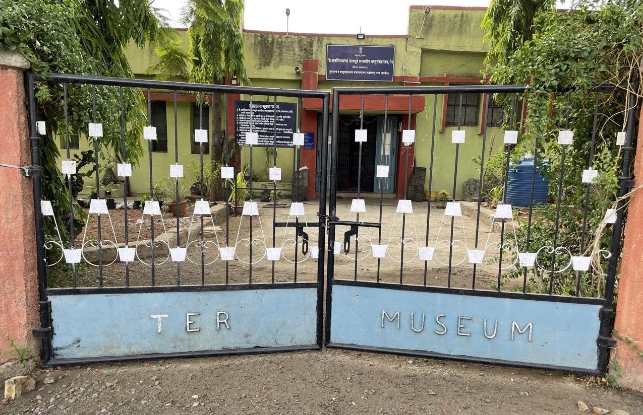
- K. Ramling Appa Lamture Shasakiya Vastusangrahalay
- Kunthalgiri Mandir
- Naldurg Fort
- Historical Background
- Structures within the Fort
- Jama Masjid
- Nar Madi (Gandhak Mahal)
- Rang Mahal
- Munsif Court
- Paranda Fort
- Historical Shifts in Power
- Defensive Design and Architecture
- Water System & Local Beliefs
- Religious and Cultural Significance
- Ramling Devasthan
- Ranmandal Fort
- Sant Goroba Kaka Mandir
- Shiv Mandir, Mankeshwar
- Shiv Mandir, Umarga
- Shri Mahalakshmi Mandir
- Sonari Mandir
- Legends and Local Belief
- Rituals and Offerings
- Festivals and Agricultural Significance
- Land Ownership and Maintenance
- Ter
- History of Ter
- Etymology of Ter
- Trivikrama Mandir
- Tulja Bhavani Mandir
- Legends Surrounding Tulja Bhavani Mandir & the Devi
- Architecture & Layout
- Rituals & Ceremonies
- Uttareshwar Mandir
- Kaleshwar Mandir
- Yedeshwari Mandir
- Sources
DHARASHIV
Cultural Sites
Last updated on 3 November 2025. Help us improve the information on this page by clicking on suggest edits or writing to us.
Bombale Hanuman Mandir
Bombale Hanuman Mandir, also known as Bomblya Maruti, is a small hilltop Mandir located near Jijau Chowk in Dharashiv. It holds local importance because of a story passed down in the village. The story behind the Mandir speaks of a time when a group of thieves, having stolen from the village, sat on the very site of the Mandir in search of gold. As they scoured the area, Bhagwaan Hanuman, in his divine form, is said to have let out a powerful and thunderous scream.
The noise was believed to be so intense that the thieves were frightened and fled, abandoning the gold they had found. Strangely, the gold turned into small pebbles, its power dissipating, and the treasure returned to its original place. The villagers believed that Hanuman’s scream had saved them from the thief and the harm it could have caused. In gratitude for his protection, the villagers later built the Mandir at the same spot, naming it “Bomblya” after the booming sound of Hanuman’s protective cry.
Today, the Mandir continues to be visited by locals who associate the space with divine intervention and protection.
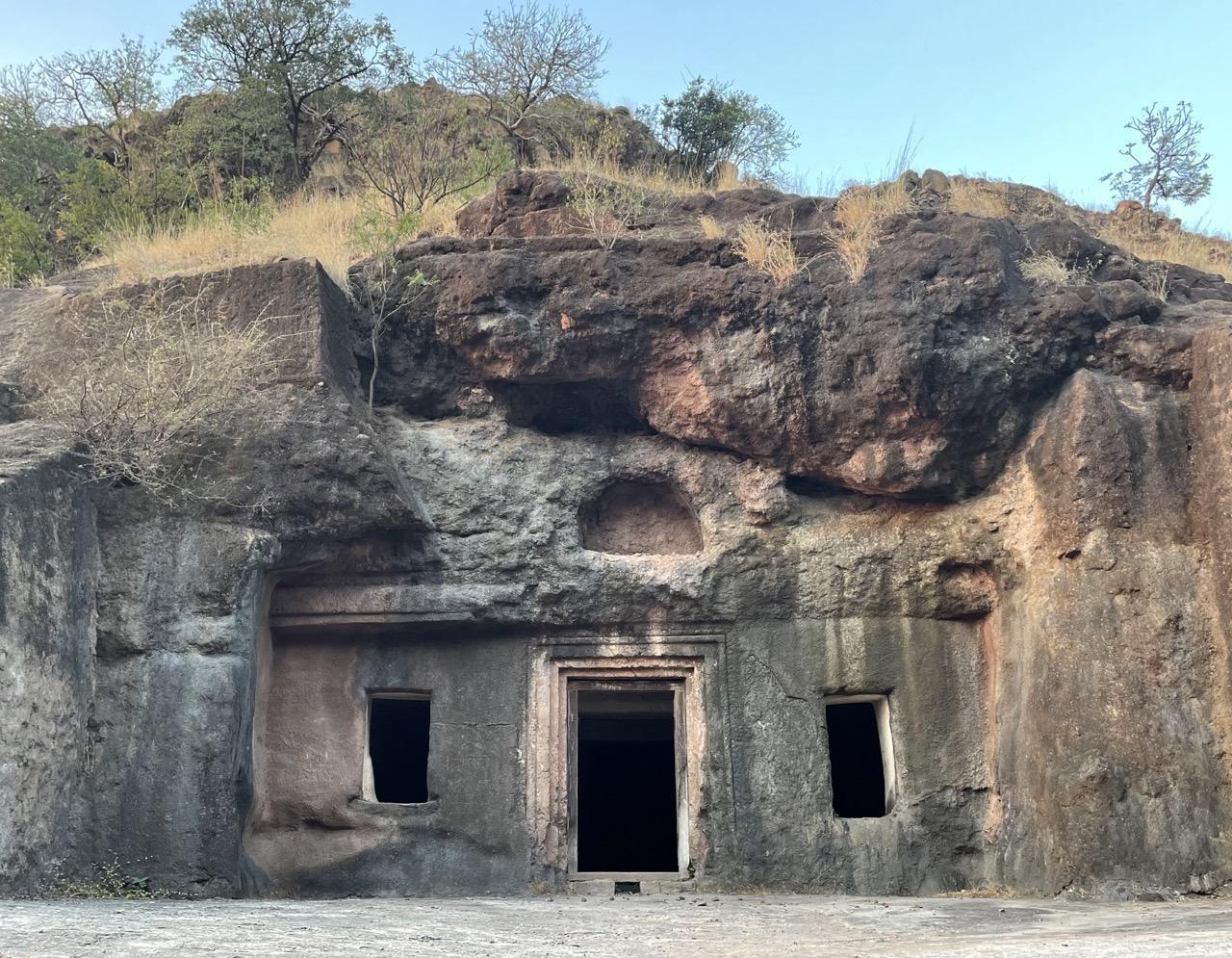
Dharashiv Caves (Leni)
The Dharashiv Caves are a group of seven ancient rock-cut caves located approximately eight km from Dharashiv city. Nestled in a hilly landscape, the caves are carved from basalt and display architectural and religious features linked to Buddhism, Jainism, and Hinduism. The site, though lesser known than other cave complexes in the region, offers insight into the religious and cultural transitions of early medieval Deccan.
Historical Context
Scholars generally date the initial excavation of the Dharashiv Caves to the 5th century CE, likely during or shortly after the Satavahana period (circa 1st century BCE–3rd century CE), though some suggest earlier origins. Significant additions or modifications are believed to have occurred under the Rashtrakuta dynasty (circa 8th to 10th century CE), a prominent ruling power in the Deccan that patronized both Jain and Hindu architecture.
The caves' stylistic similarities to other contemporaneous sites, such as Ellora and Ajanta, indicate that Dharashiv was likely part of a broader religious and monastic network in the Deccan. The site may also have served as a waypoint for traders and yatris along regional trade routes.
Etymology and Legends
The name "Dharashiv" is explained through multiple local and scholarly theories. One widely held account attributes the name to Shiv Raja, a local ruler from nearby Ter, who is believed to have discovered the caves. According to tradition, a stream once flowed near the caves, and the name is thought to be a combination of “Dhara” (stream) and “Shiv” (name of the king).
Dr. Somnath Rode, who studied the site for his doctoral thesis, supports the theory that Shiv Raja commissioned or developed the site after identifying a reliable water source. In contrast, Mahadevshastri Joshi, a Marathi historian, proposed that the name comes from two guards named Dhara and Shiv, who were assigned to protect the caves. Before the establishment of the caves, it is said that the region was known as Nagesh Nagari.
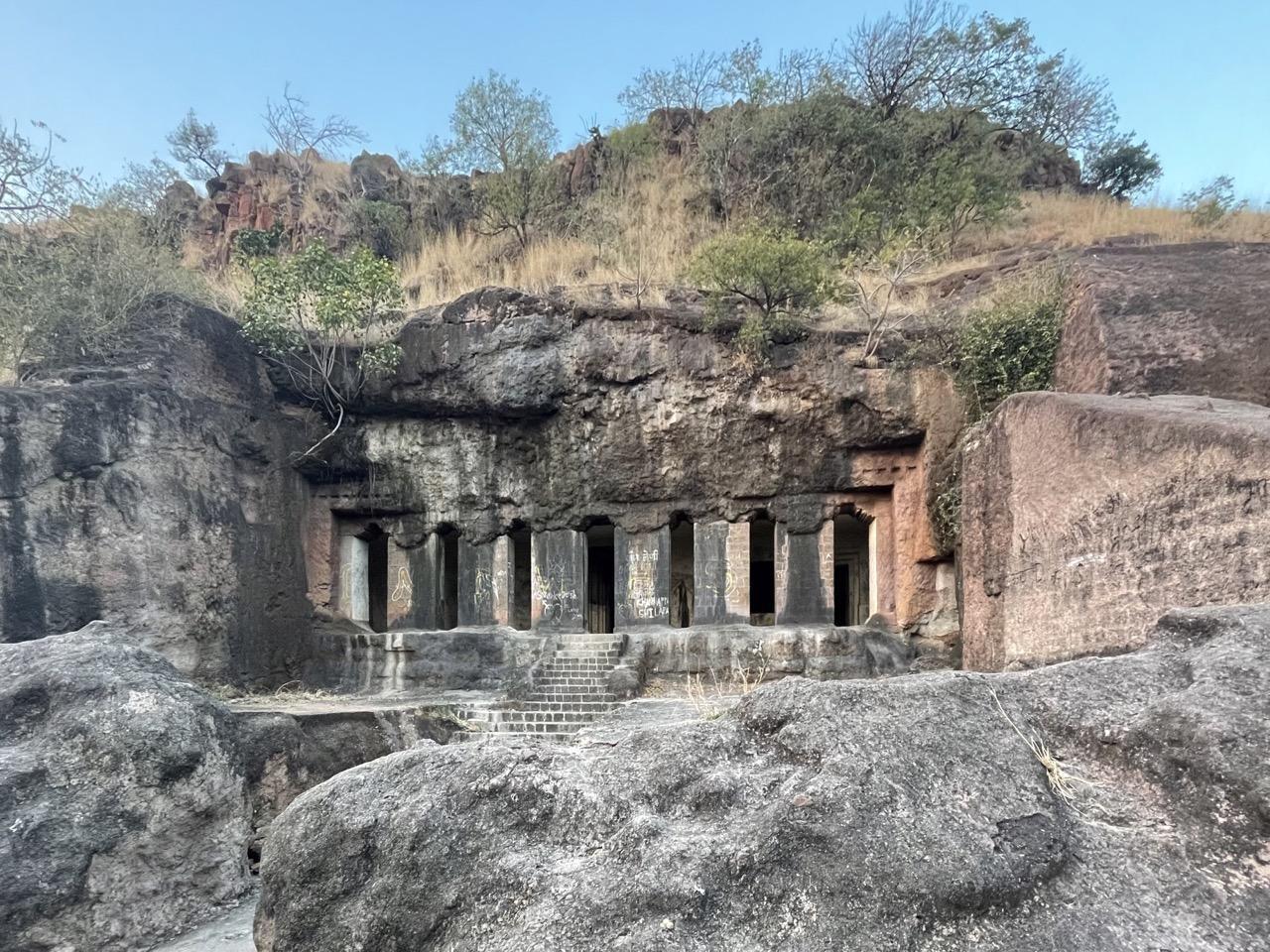
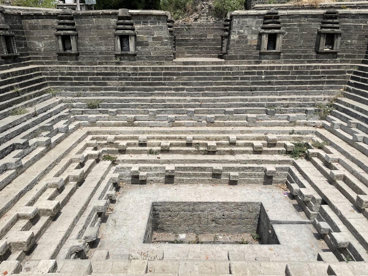
Layout and Architectural Features
The caves are situated in a hilly region accessible by a stairway descending from the main road. During the monsoon season, small seasonal pools locally called Malrana form in the area. The site consists of seven caves, arranged non-linearly across the slope.
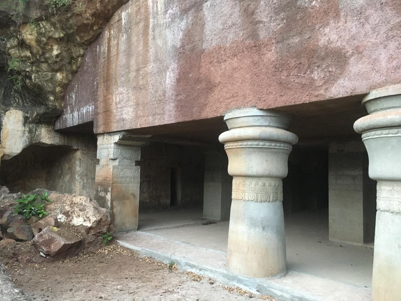
Caves 1 through 3 contain Buddhist architectural features, including a chaityagriha (prayer hall), viharas (monastic dwellings), and a garbhagriha (sanctum) housing a seated sculpture of Gautama Buddha in padmasana (lotus position). One of these is believed to be modelled after the caves of Ajanta, dating to the Vakataka period (circa 250–550 CE).
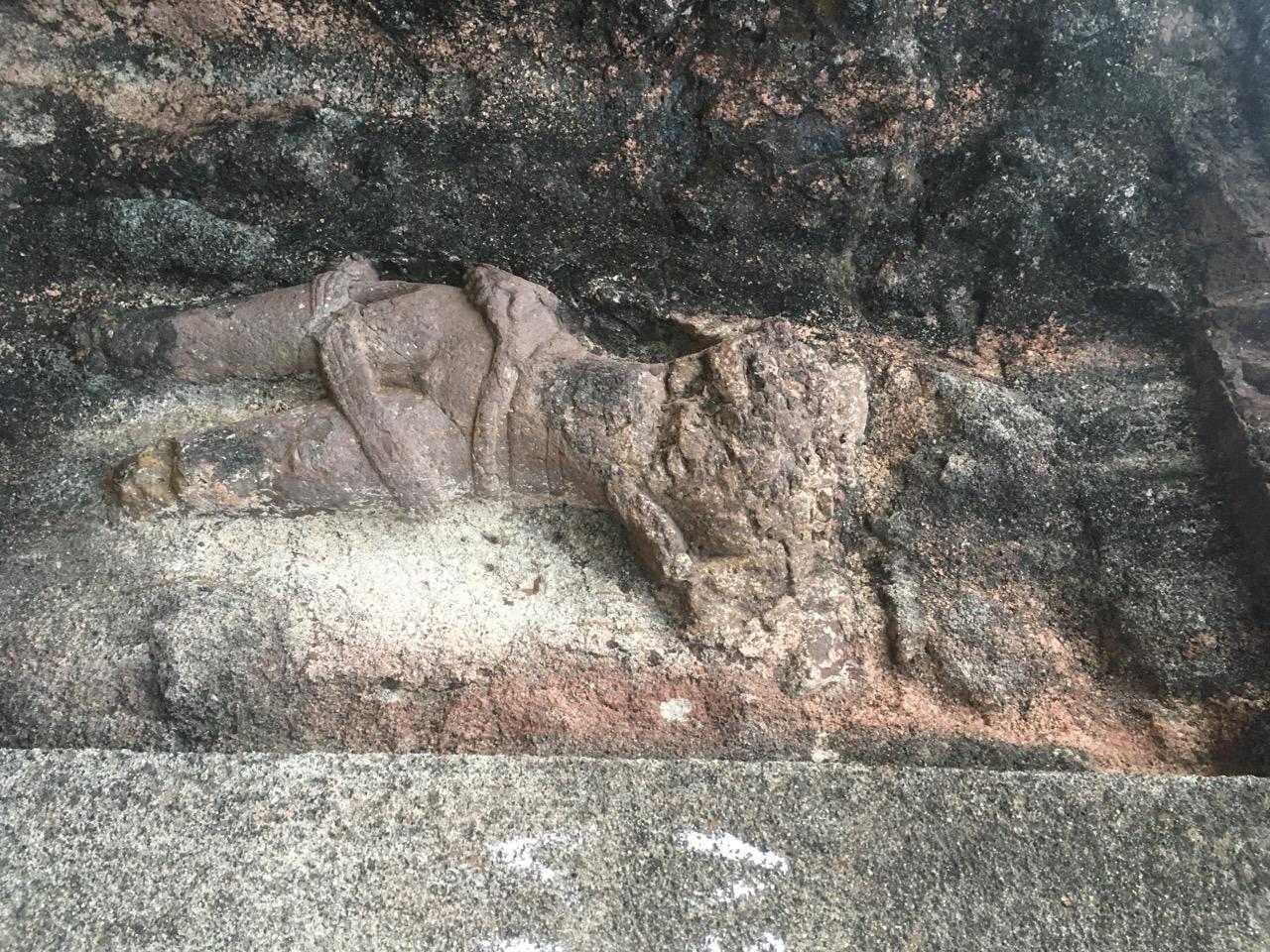
Caves 4 through 7 exhibit Jain features, such as intricate stone carvings and iconography associated with Jain Tirthankaras. The presence of both Buddhist and Jain structures within the same complex suggests either concurrent usage or phased religious transitions. Additionally, minor Hindu carvings are found, indicating reuse or adaptation during later periods.
Over the centuries, the caves were used and reinterpreted by multiple religious communities. The original Buddhist function appears to have given way to Jain usage, possibly during the Rashtrakuta period, a time when Jainism received significant patronage. The presence of Hindu mandirs carved into the rock, as well as surface-level religious structures, suggests further adaptation during later periods.
During the Peshwa period, the site became associated with a spiritual figure named Hari Narayan, who is believed to have meditated in the area. A math connected to his followers is still found near the caves.
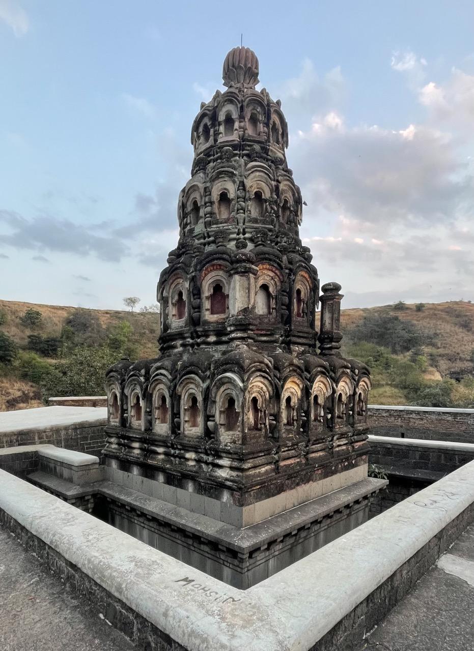
At the base of the cave complex stands a Mandir built during the Nizam period. Constructed in the traditional wada style, the Mandir includes arched verandas and resting areas for visiting yatris. It is traditionally believed to house the mausoleum of Shiv Raja, reinforcing his association with the site.
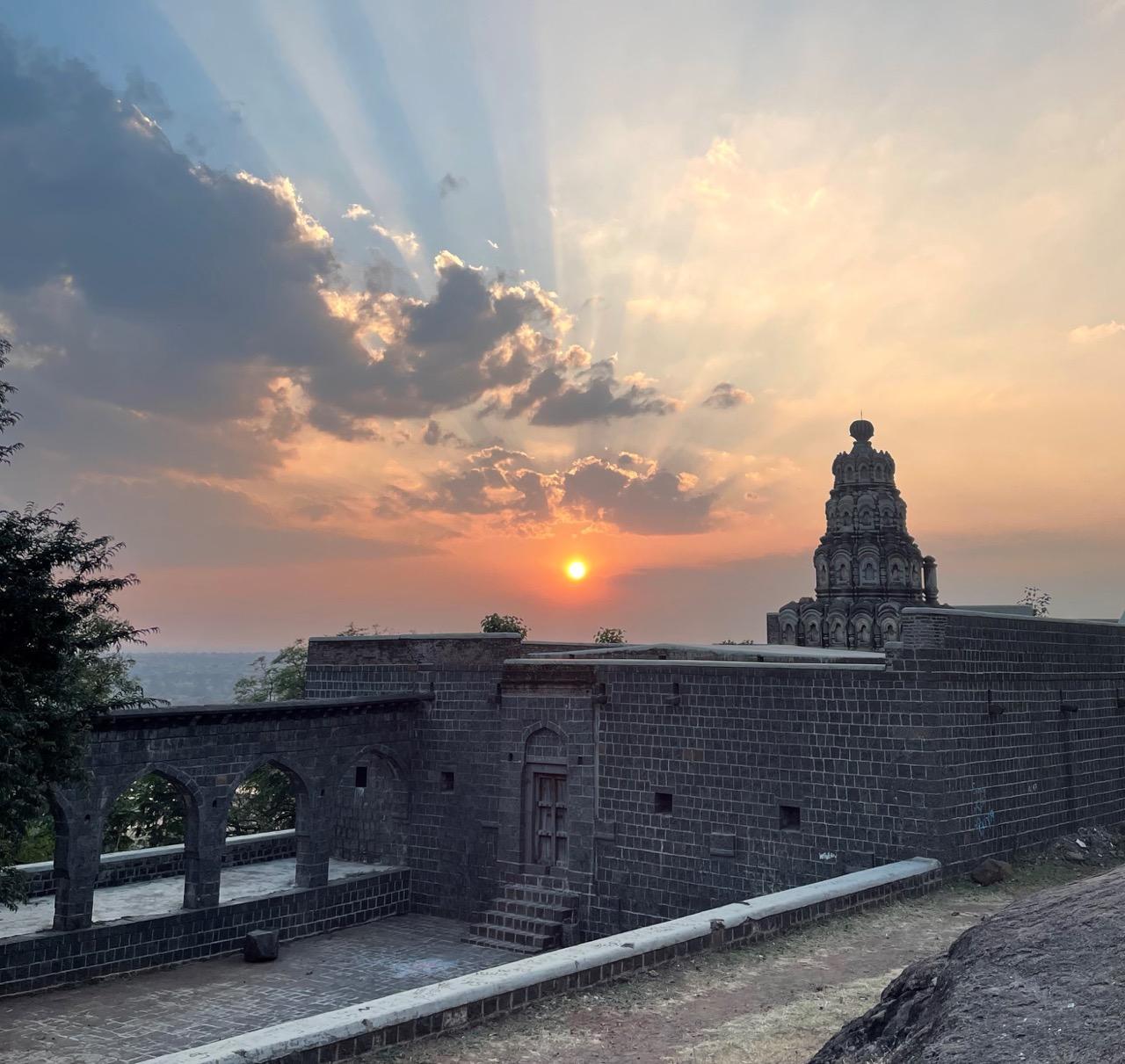
The Mandir remains active as a site for tirtha yatra. Every year, during Ashadhi Purnima and Kartiki Purnima (full moon days in the Hindu calendar, associated with tirth yatras), groups of Varkari devotees gather at the Mandir for communal worship and ritual observance, often staying for two days.
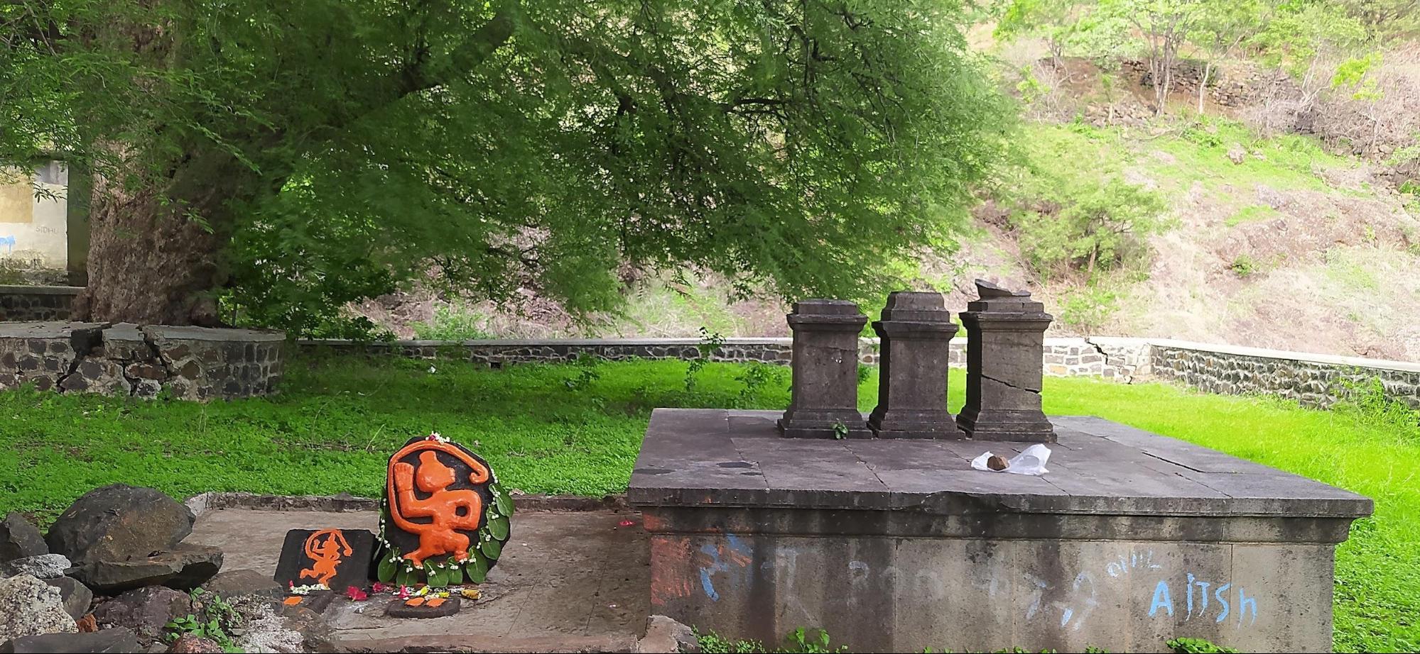
Near the Mandir stands a large tamarind tree, under which lies a platform holding a vermilion-smeared murti of Maruti. Adjacent to this are three samadhis, which local tradition identifies as the final resting places of Shiv Raja’s mother, sister, and wife.
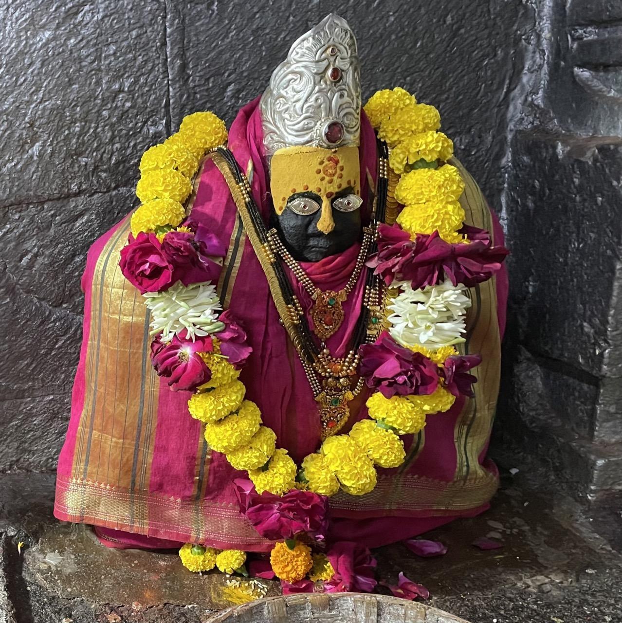
Hatla Devi Mandir
Hatla Devi Mandir is a local mandir located near Khanapur, Dharashiv. Interestingly, it is tied to the legend surrounding Devi Bhavani. According to local lore, during the legendary battle between the Devi and the rakshas Mahishasur, Bhavani severed his arms and cast them aside. It is said that the limbs of the rakshas landed on the edge of a hill, and over time, villagers built a Mandir at the site. This is how Hatla Devi came into being, as another manifestation of her divine strength.
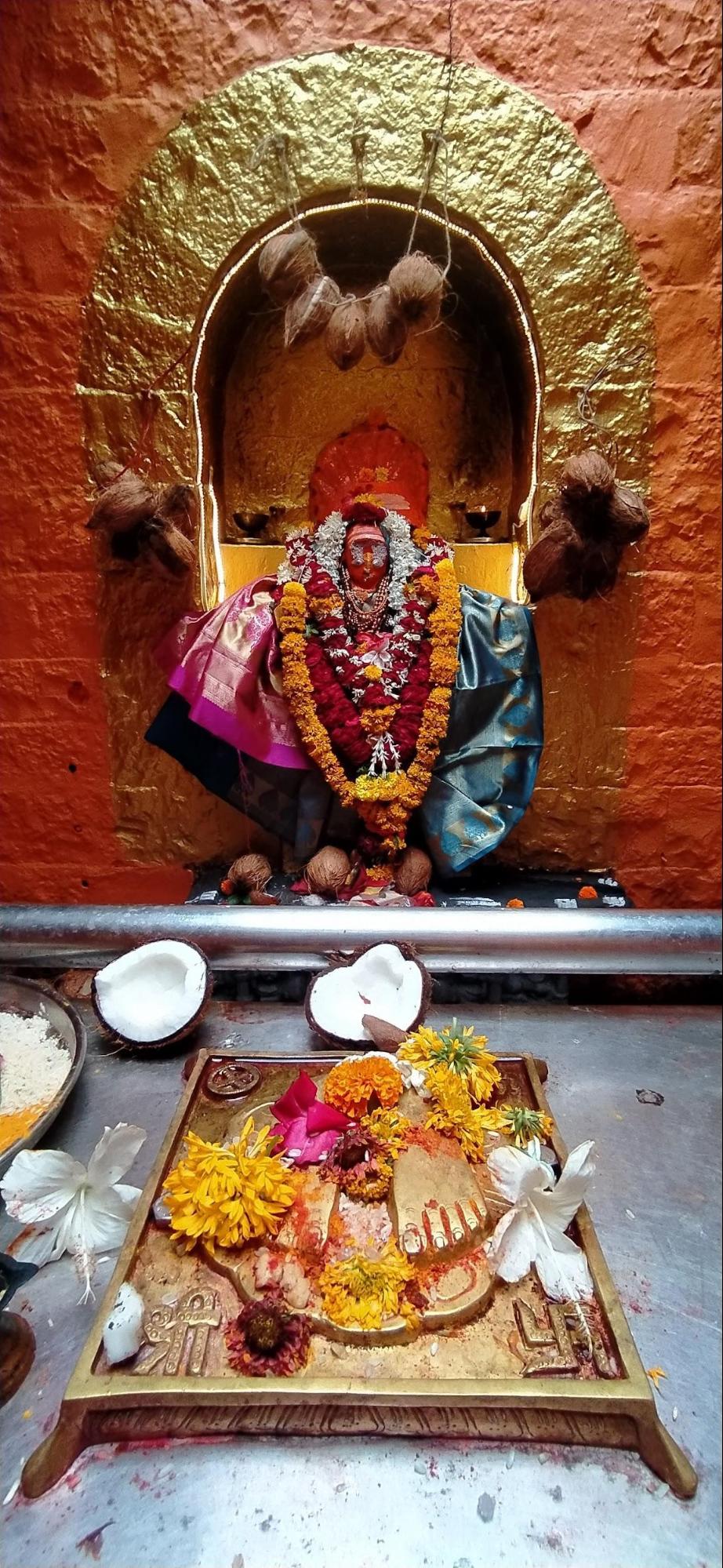
The Mandir is accessible via Hatla Devi Mandir Road, which begins at Jijau Chowk. A marked archway signals the entrance to the approach path. The Mandir can be reached by a short walk from the ghat road, though many visitors use vehicles to drive directly to the Mandir steps.
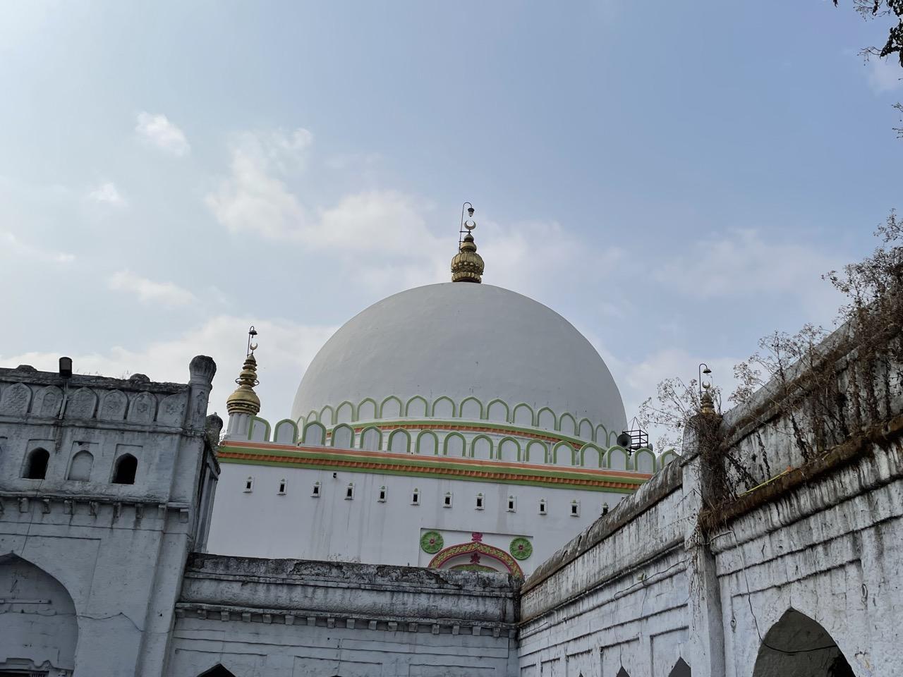
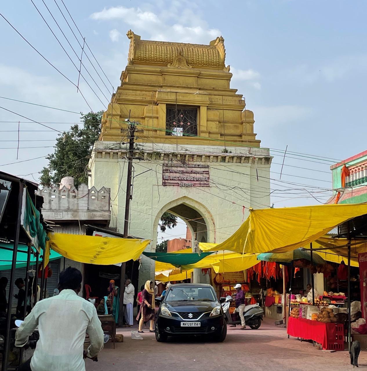
Hazrat Khwaja Shamsuddin Gazi Dargah
Hazrat Khwaja Shamshuddin Dargah is located in Khwaja Nagar, Dharashiv, and holds long-standing significance for the local community. The site is associated with multiple narratives about its origin and the sant it honors.
According to Shafik, the current caretaker and a 23-year-old maulana from a family that has served the dargah for five generations, the structure was built by a king from the Maldives. He adds that many of the king’s followers are buried nearby and traces his own lineage to this group. Another view holds that the dargah was a gift from Tughlaq Badshah, founder of the Tughlaq dynasty, in the 14th century. Yet another narrative suggests the structure was originally built deep in a forest to drive away negative forces, referred to locally as shaitaan ka zurm (ghosts or harmful energies).
Etymology & Association with Saints
The dargah is named after Khwaja Shamshuddin Ghazi Baba, a figure remembered for his spiritual knowledge and, according to local tradition, his military victory.
Oral accounts say that after this victory, he travelled to Delhi, where he studied Islamic sciences under his father, Hazrat Syed Abdur Rahman Husaini. After completing his studies, he was granted a spiritual order and returned to settle in this region.
The dargah complex contains the qabar of Khwaja Shamshuddin, along with those of his close friends and family members. A separate mazaar holds the qabars of relatives believed to have migrated from Iran, including two brides, a son, a grandson, and others.
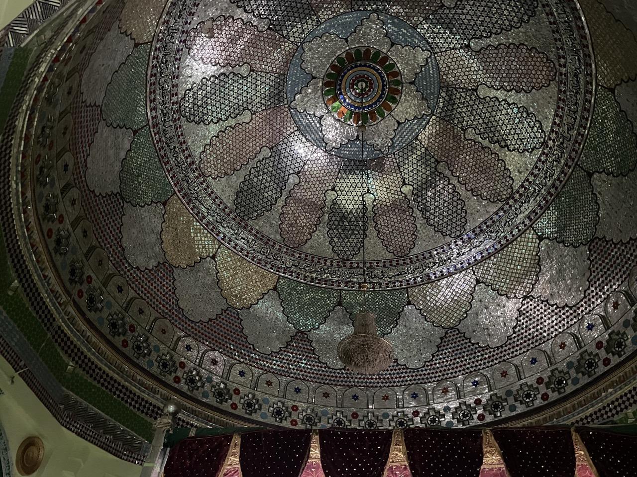
Architecture
The architecture of the site is beautiful and quite noteworthy. The dargah, architecturally, is best known for its dome, which many consider to be the largest of its kind in the Marathwada region. The inner walls feature glass inlay work, added in 2004 by local artisan Gulbar Mistry. Based on oral tradition, the structure is believed to be around 715 years old, with some accounts suggesting it was built by Iranian craftsmen.
Festivals & Customs
Every February, Urus (a commemorative celebration, particularly of the death anniversary of a Sufi saint), is hosted at the site, which draws large crowds. A popular tradition practiced at the dargah involves newly married women applying turmeric paste (haldi), sandalwood paste (chandan), and henna (mehndi) to their fingers. They then place their right fingers on the dargah walls, leaving an imprint. This custom is widely believed to bring blessings for a prosperous and healthy marriage.
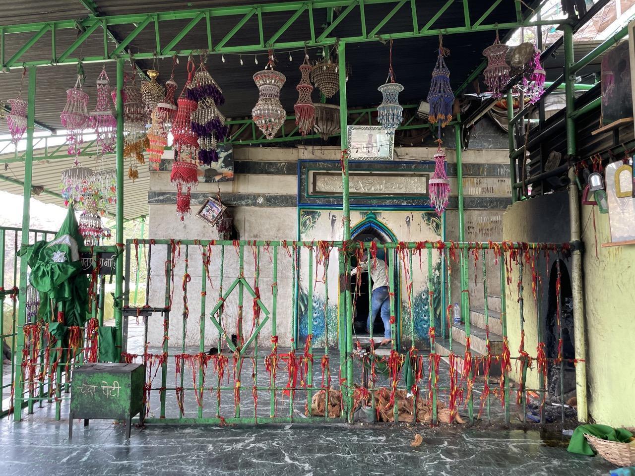
Hazrat Khwaja Sheikh Farid Shakarganj
The Hazrat Khwaja Sheikh Farid Shakarganj is located in Kumalwadi, about half an hour from Shamsuddin Dargah. It is a syncretic shrine where many locals from diverse communities visit.
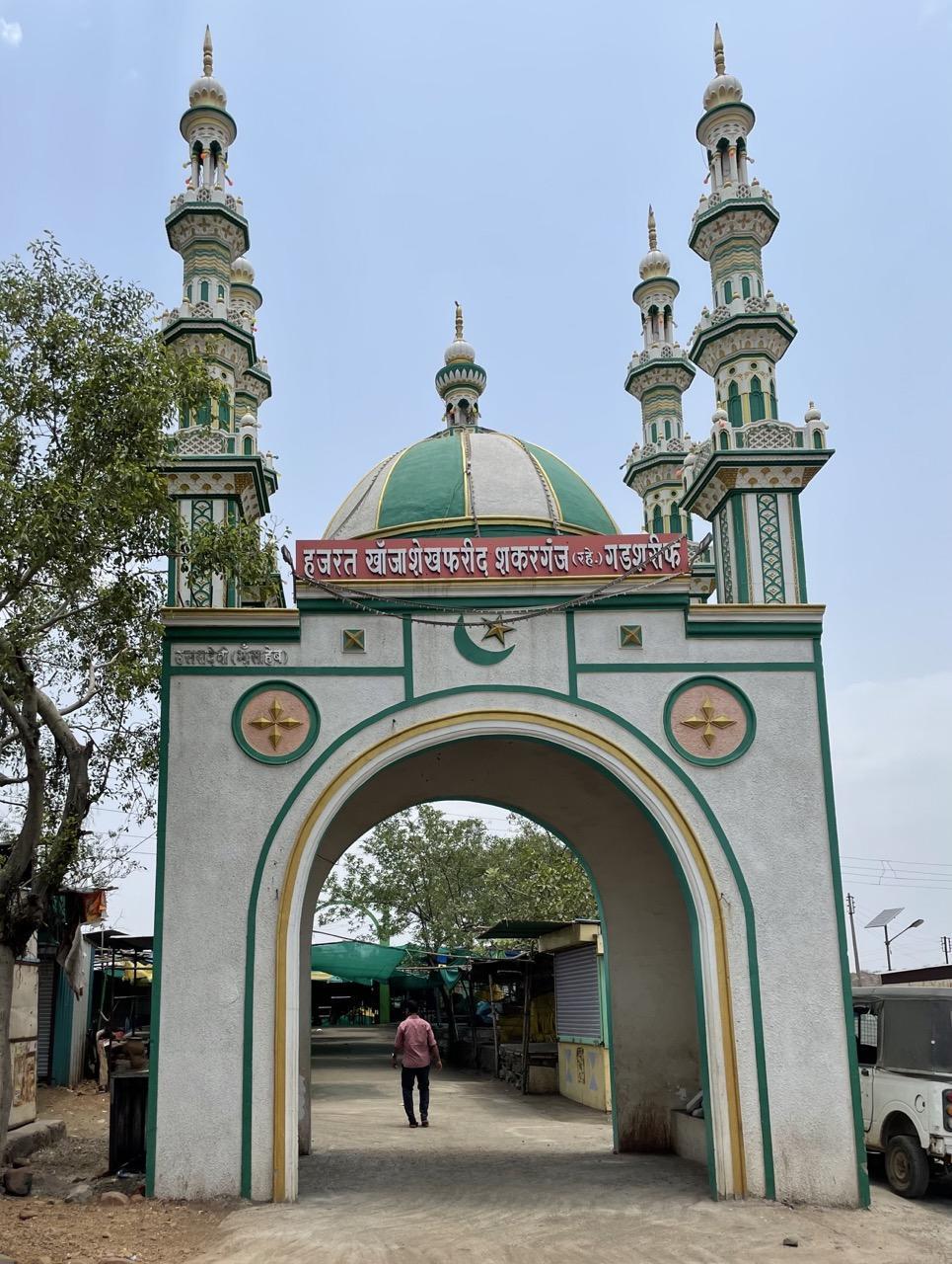
The Khwaja who is revered at the site is Sheikh Farid Shakarganj, and there is an interesting story tied to him and this site. According to local tradition, he is believed to have meditated here while standing on his head for 36 years. The site also includes multiple spaces dedicated to sants who are said to have lived, prayed, and been spiritually active in the area.
K. Ramling Appa Lamture Shasakiya Vastusangrahalay
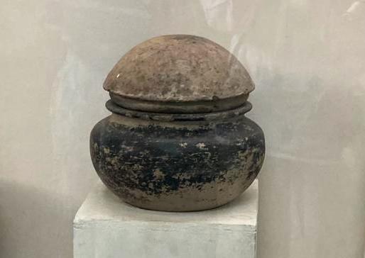
The K. Ramling Appa Lamture Shasakiya Vastusangrahalay is a government-recognized museum located in Ter, Dharashiv district. It houses a collection of archaeological and cultural objects primarily found in and around the Ter region, historically identified with ancient Tagar, a known inland trade center in early Indian history. The museum is named after Ramling Appa Lamture, a local resident who began collecting artifacts after noticing their frequent appearance during construction work in the area.
According to local accounts, his efforts were partly prompted by an encounter with a foreign researcher who was allegedly collecting similar objects for private sale abroad. After learning of the researcher’s intentions, Lamture, alarmed by the potential loss of these priceless items, embarked on his own quest to preserve the artifacts. It was this pivotal moment that led to the formation of the museum.
The museum’s collection spans several centuries and reflects various phases of the region’s history. Notable among the holdings are coins from the Satavahana period, some dating to the 3rd century BCE. These coins include symbols associated with both Buddhist and Jain traditions, providing insight into the religious and economic contexts of the time.
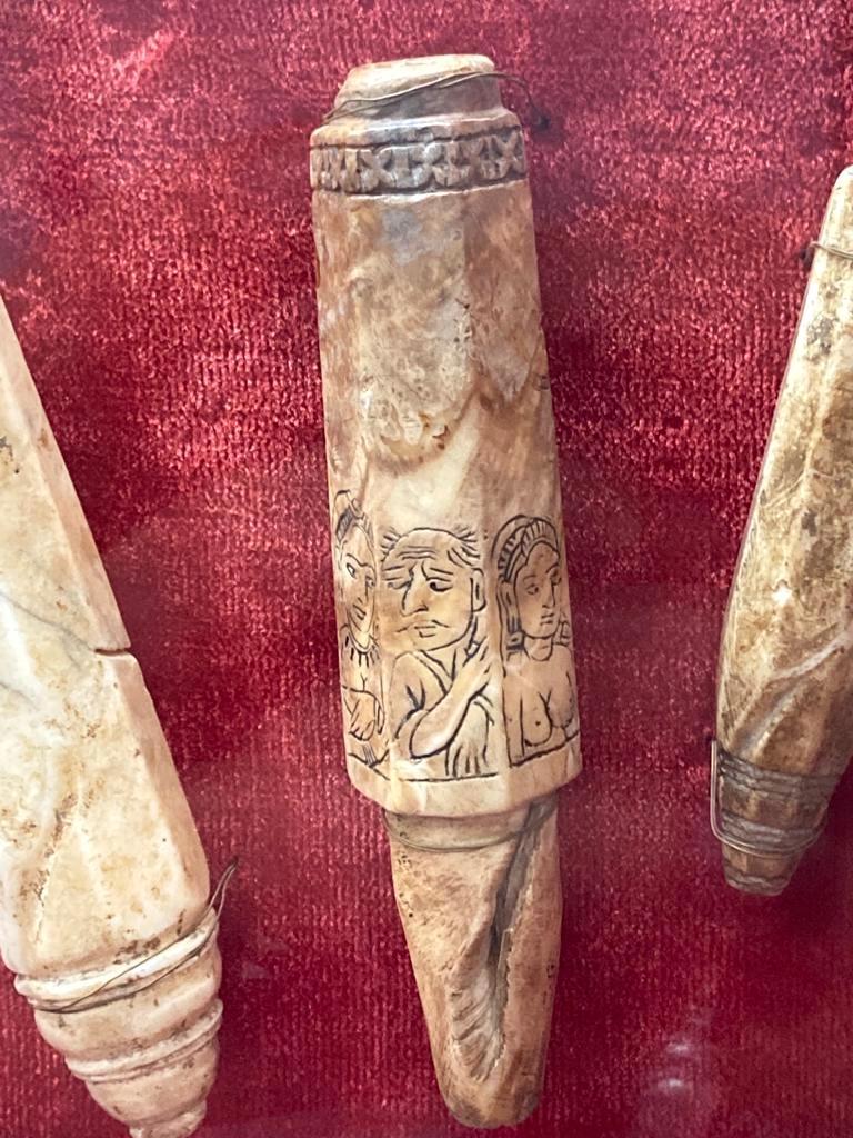
Other important objects include a series of small stone murtis known locally as Devache Tak, dated to the 15th and 16th centuries. These figurines reflect devotional practices and local iconography. The museum also displays carved mirror handles, said to be mercury-coated, featuring intricate designs that depict clothing and accessories, providing information about dress and grooming practices during the period.
The museum also houses terracotta pots influenced by Roman designs, suggesting a significant cultural exchange between the region and the Roman Empire. Some of these pots, known as Megenan pots, were used by bhikkhus (monks) who travelled from village to village asking for alms. Other significant finds include amphoras, which were Roman wine storage vessels, possibly pointing to the import of wine from Rome, possibly for local rulers or elites.
Archaeological evidence suggests that Ter was a site of ornament and coin production, with molds and tools indicating craft activity beyond household scale. Sculptures found in the region depict female figures in stylized postures and detailed attire, providing insight into social customs and representation.
A sculpture of Lajja Gauri, a Devi widely associated with fertility, is displayed at the museum. Her iconography, often interpreted as representing birth, menstruation, and the generative power of the female body, has been the subject of both religious devotion and academic study.
The museum also displays small artifacts such as dice, kajal applicators, and decorative pieces. A sculpture referred to as the “shy girl” is also displayed here. This motif is popularly connected to a verse from the Gatha Saptashati, attributed to Satavahana king Hala, in which a woman reacts in embarrassment after being seen by the king.
Notably, some observers have noted stylistic similarities between sculptures from Ter and those found in Pompeii. Ornamentation on certain artifacts includes crocodile (magarika) motifs, a recurring element in regional jewelry design.
Interestingly, among the exhibits is a fired brick, which is noted for its unusually low density. Made from a mixture of rice husk and mud, the brick was baked twice, a process that introduced air pockets into its structure. As a result, the brick is light enough to float in water. This technique reflects an understanding of material properties and construction methods in the region during earlier periods.
The museum continues to function as a repository for such artifacts, offering insight into the technological, cultural, and architectural practices of Ter and its surrounding region.
Kunthalgiri Mandir
Kunthalgiri Mandir is located on a 175-foot hill in Maharashtra and is a major Digambar Jain site. It is considered a siddha kshetra, a place where Jain bhikkhus are believed to have attained liberation. The complex houses 11 mandirs; four of these are situated at the base of the hill, while the other seven are spread across the hill.
The central Mandir is dedicated to Desbhushan and Kulabhushan (royal-born Jain bhikkhus and brothers), who, according to tradition, gave up their kingdoms to undertake penance at this site. Their time here is said to have taken place during the era of Munisuvratanatha (20th Jain Tirthankara). Some versions of the story connect their presence at Kunthalgiri to the forest exile of Ram, Lakshman, and Sita. It is believed that the two monks attained kevalgyan (omniscience) here.
In 1955, Acharya Shantisagar Maharaj (renowned Digambar Jain bhikkhu) undertook sallekhana (ritual fasting unto death) at Kunthalgiri. A memorial to him stands within the complex.
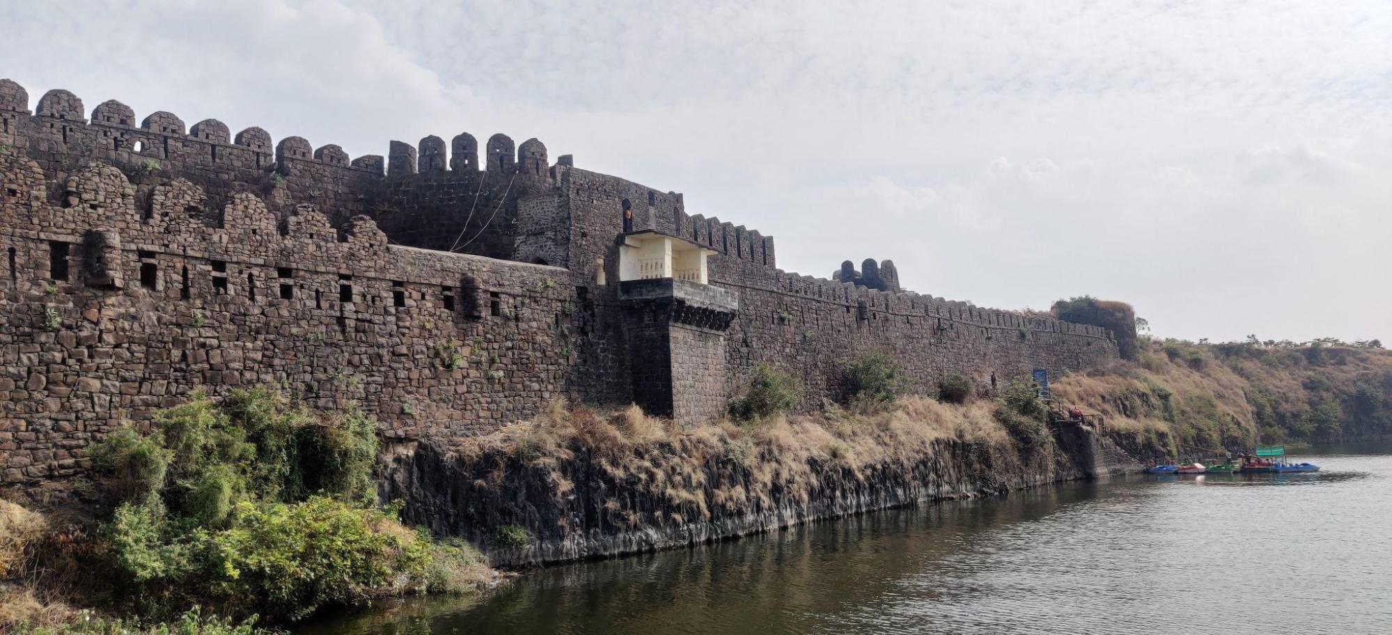
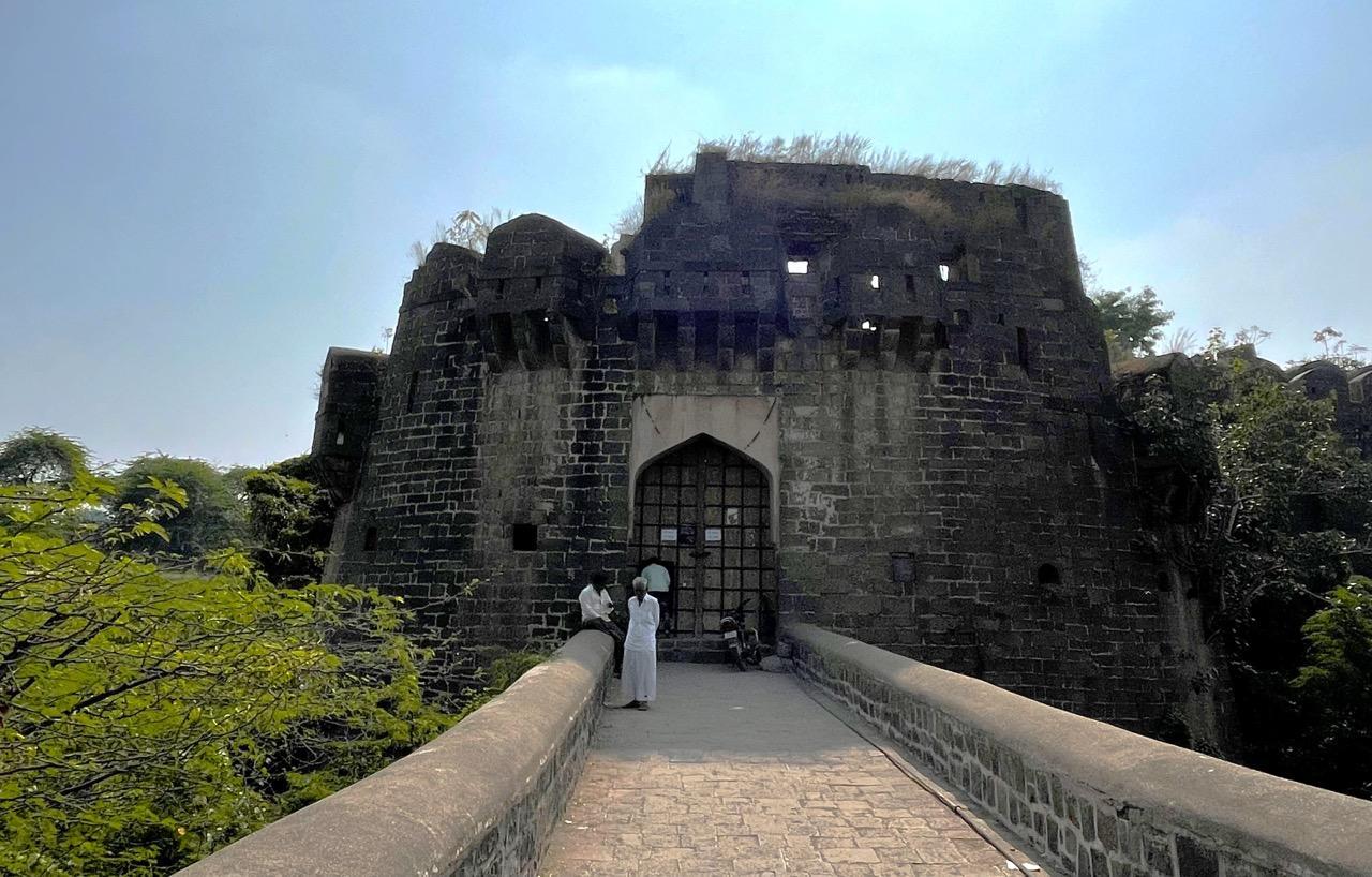
Naldurg Fort
Naldurg Fort is a large medieval stone fort located in Tuljapur taluka. Considered one of the largest land forts in the state, it is situated along the Bori River and named after a local ruler, King Nal. The fort is notable for its extensive stone walls, moats, Indo-Islamic architecture, and strategic military role throughout the Deccan's medieval history.
Historical Background
The origins of the fort are traditionally linked to King Nal, who is said to have ruled the region before the Islamic conquests in the Deccan. Local guides often claim that Nal built the fort after defeating the Vakataka dynasty (c. 250–500 CE). However, much of its early history remains unknown.
In the district Gazetteer (1972), an account by British officer Colonel Meadows Taylor, stationed in the district between 1853 and 1857, is noted, where he writes that “Nuldroog held a memorable place in local history. Before the Muslim invasion in the 14th century, it belonged to a local Rajah, who may have been a feudal vassal of the great Rajahs of the Chalukya dynasty, whose capital was Kalyani, about 40 miles away. However, I never could trace its history with certainty…”
The region came under the Badami Chalukyas (c. 543–753 CE) and later the Western Chalukyas, who maintained control until the arrival of the Bahmani Sultanate in the mid-14th century. During this period of early fortification, the site began to take shape as a military stronghold in the Deccan.
With its imposing structure and geographic location on the contested borders of multiple dynasties, the fort was of continued strategic importance throughout the medieval period, especially during the conflicts between the Adil Shahi rulers of Bijapur and the Nizam Shahis of Ahmednagar. It was later incorporated into the Mughal Empire and eventually came under the control of the Nizams of Hyderabad, remaining with them until Indian independence.
Structures within the Fort
The fort contains a number of architecturally and historically significant buildings, each reflecting the needs and aesthetics of its time. The outer perimeter of Naldurg is lined with, locals estimate, 114 watchtowers, an unusually high number for a Deccan fort. The tallest reaches approximately 100 ft., providing extended visibility and strategic oversight of the surrounding terrain.
Within the walls, a series of buildings, ranging from religious and royal to administrative and military, exemplify the fort’s layered architectural heritage. The intricate carvings and decorative elements combine Islamic, Persian, and regional influences, forming what is broadly identified as an Indo-Islamic style.
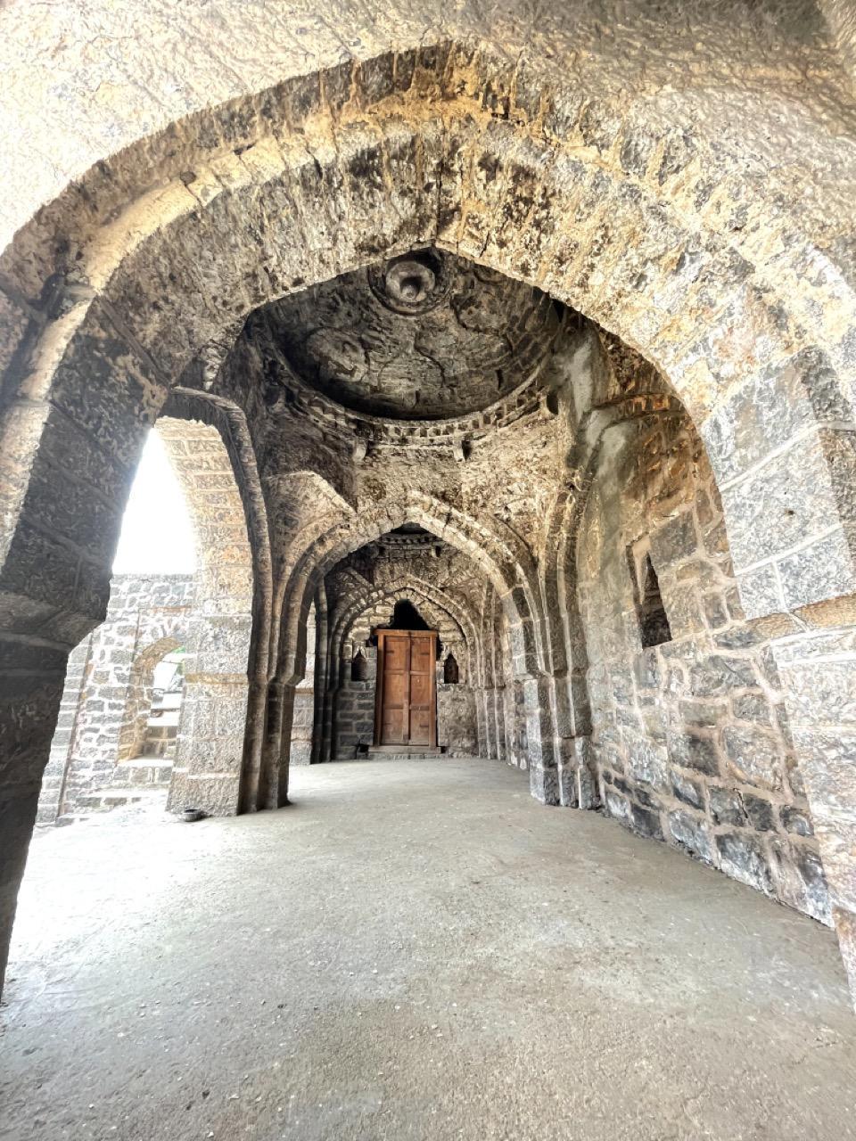
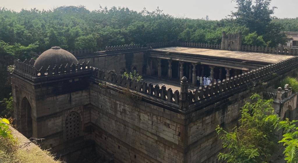
Jama Masjid
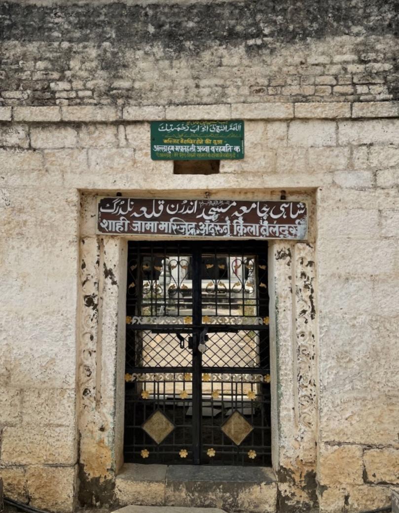
One of the major structures within the Naldurg Fort, the Jama Masjid was constructed in 1560 during the reign of Ibrahim Adil Shah I. The masjid stands on a raised stone platform and features ten minarets, intricately carved pillars, and Persian inscriptions. The masjid also serves as the final resting place for Nawab Amir Nawaz Ul Mulk Bahadur and his wife, Begum Fakhrunisa, adding to the fort’s historical importance.
Nar Madi (Gandhak Mahal)
Another key structure within the Naldurg Fort, Nar Madi, also known as Gandhak Mahal, is believed to have been constructed during the reign of Ibrahim Adil Shah II in 1613. It is speculated that the palace was designed to withstand natural disasters, such as earthquakes, given the region's occasional seismic activity.
Some even suggest that the palace’s resilient architecture may have been intended not just for defense but to symbolize the enduring strength of the royal family. An intriguing detail is the image of Bhagwan Ganesh that adorns the palace’s entrance, possibly reflecting a cultural fusion, or it may have been a symbol of protection.
Rang Mahal
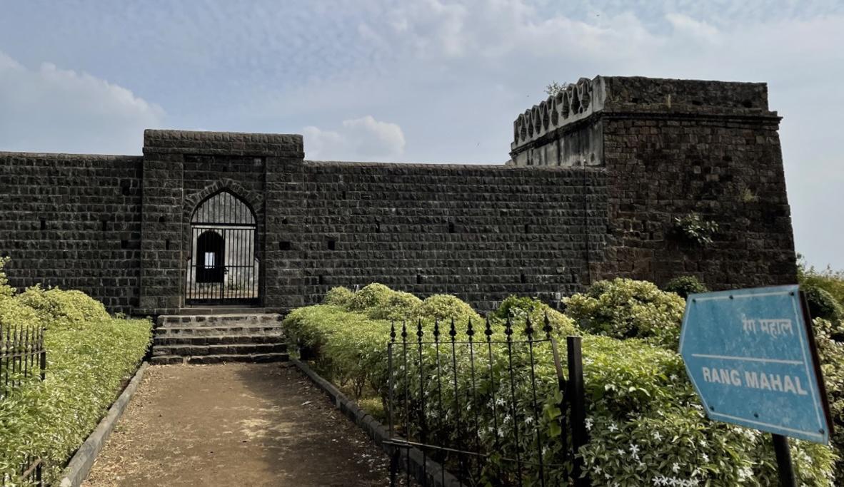
Rang Mahal is one of the prominent structures within the Naldurg Fort, designed as a domed palace for royal gatherings, musical performances, and celebrations. It includes seven rooms, a terrace, and a bathroom and is said to be bombproof in its construction. The 1587 royal marriage between Ibrahim Adil Shah II and Mallika Jahan, sister of Muhammad Quli Qutub Shah of Golconda, is believed to have taken place here.
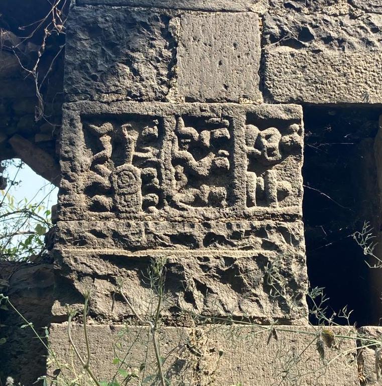
Munsif Court
Among the notable buildings inside Naldurg Fort is the Munsif Court, which dates to the Nizamshahi period and functioned as both a court and a prison. Its chauthra (raised platform) is made from an alloy of five metals and features carvings of lions, horses, and cannons along with Persian inscriptions.
Today, Naldurg Fort is protected under the Maharashtra Vaibhav State Protected Monuments Conservation Scheme. It is currently managed by Unity Multicons Pvt. Ltd., a Solapur-based conservation agency. Although partially restored, the site remains vulnerable to weathering and lacks comprehensive visitor infrastructure.
The fort continues to attract visitors for its panoramic views, historic ruins, and unique blend of military and cultural architecture. The nearby town of Naldurg derives its name from the fort, a testament to its long-standing regional significance.
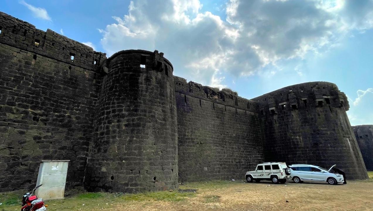
Paranda Fort
Paranda Fort, situated in the town of Paranda, in Dharashiv district, is relatively small in scale but is considered to be exceptionally well-designed. The fort includes a network of internal routes, multiple entrances, and water channels, all integrated into a compact layout. Its rampart walls are reinforced with 26 strong, rounded bastions, designed to provide a wide firing range and structural resilience.
The fort is also surrounded by a defensive outer embankment, locally referred to as a ‘maat’ or ‘khadak,’ which is structurally integrated with the fort itself. Several secret routes are connected to regions outside the fort. The fort is structurally designed to defend and protect those inside it.
Locals share various stories about the origin of Paranda Fort. The most popular one is that it was laid out by Mahmud Gawan, the prime minister of Muhammad Shah of Bidar, who used it as his residence. Others claim that the fort was well-protected because only female residents lived there. Yet other stories claim that the fort has never been used as an army base or for any military purposes. This is simply due to the fact that the region has an extremely dry climate, making it difficult to supply enough water for a favorable army base.
Interestingly, a local legend states that the fort was built in 1124 CE and that it will celebrate its 1,000th anniversary in 2124, although this date remains speculative.
Historical Shifts in Power
Historically, Paranda has witnessed numerous shifts in power. It is mentioned in the district Gazetteer (1972) that following the fragmentation of the Bahmani Sultanate (1347–1527), Paranda came under the control of the Ahmadnagar Sultanate (1490–1636). When the Mughals (1526–1857) captured Ahmadnagar in 1600, the fort briefly served as a provincial capital. It was taken by the Bijapur Sultanate (1490–1686) in 1630, but again fell to the Mughals in 1657. A notable episode in 1669 involved Kazi Haider, an emissary of Shivaji Maharaj of the Maratha Empire (established 1674), who was imprisoned at Paranda during a period of tense diplomacy between the Marathas and Mughals.
Defensive Design and Architecture
Paranda Fort is known for its labyrinthine layout, hidden passages, and multi-layered defensive systems. Its outer walls are reinforced with 26 rounded bastions, each designed to support artillery and defend against siege warfare. The bastions form a continuous line of defense, integrating into the broader plan of the fort.
Surrounding the main fortification is a maat or khadak, which links the fort’s bastions to the outer terrain. Several concealed routes connect the fort to surrounding areas, further highlighting its strategic intent. These features allowed defenders to either retreat or flank attackers without detection.
Notably, the fort has four known entrances, but none is clearly marked as the main gate. This lack of a designated primary access point is often interpreted as a defensive feature, intended to obscure points of entry and delay attackers. Internal pathways and passages are narrow and layered, reinforcing the fort’s defensive design.
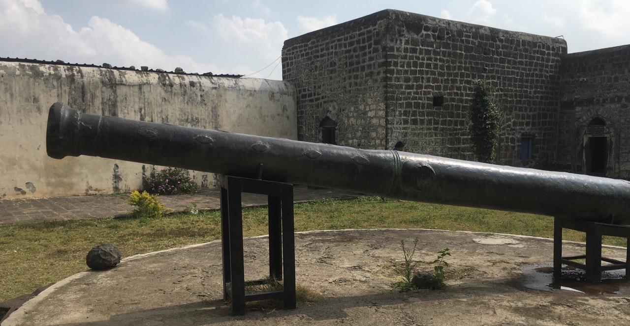
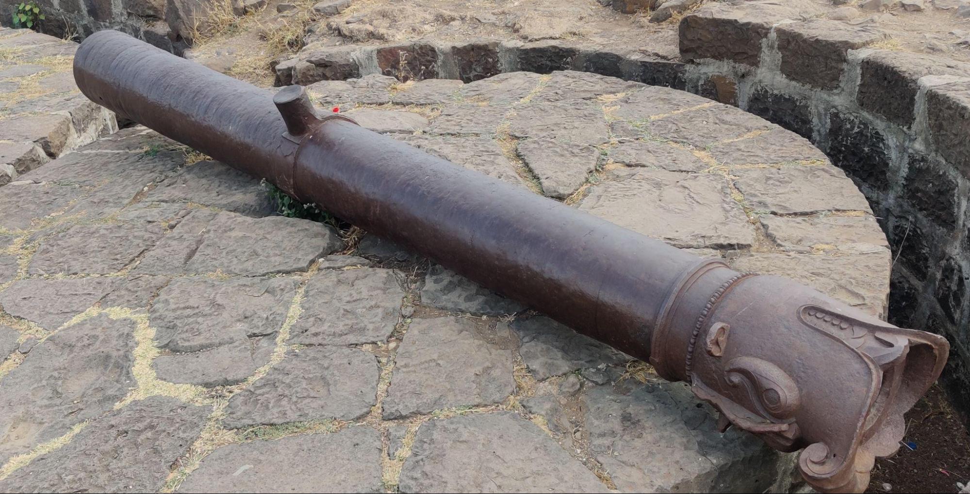
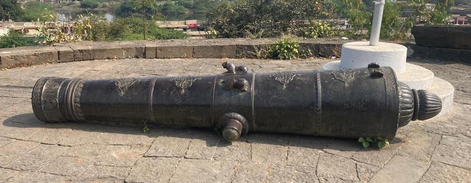
Paranda Fort is particularly known for its historic cannons, many of which are still preserved on-site. Among them is the Hussain Arab, a cannon believed to have been cast by Arab engineers in service of the Bijapur Sultanate. Others are attributed to Dutch artisans, reflecting the global connections of the Deccan sultanates in the 16th and 17th centuries.
One of the fort’s original large cannons was later relocated to Bijapur, but a smaller version still remains at the site, adorned with carvings of twin lions. According to locals, one of the lions was recently stolen, hinting at the ongoing concerns over the fort’s conservation.
Water System & Local Beliefs
Located near the entrance of the fort is Ghee ki Bavar, a small water reservoir known in local accounts for its unusually sweet water. Traditionally, it was believed to have healing properties. The reservoir is now inactive, but it reflects the fort’s dependence on self-contained water systems, particularly important given the region’s dry climate.
Religious and Cultural Significance
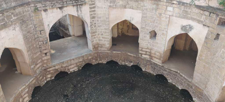
In addition to its military history, Paranda Fort is also known for its religious and cultural significance. The fort houses the Jami Masjid, which was regularly visited by the Nizams to pray. The masjid, with its 27-bayed prayer hall and domed Hamam, is said to be one of the oldest in India.
Paranda also holds cultural significance as the former residence of Sant-poet Hansraj Swami, a revered figure of the 18th century. According to the Gazetteer (1972), his writings have been preserved in the math (religious center) located within the fort. This adds a layer of regional religious history to the site, though its primary function remained military.
Ramling Devasthan
Ramling Mandir is located in Yedshi, tucked into a ravine that hides its golden shikhara from plain sight. The Mandir sits on elevated ground and is accessed by a flight of steps. A wide courtyard surrounds the main structure, with a sabhamandap (assembly hall) leading to the inner garbhagriha.
The mandir houses a pindi of Bhagwaan Vishnu. Local stories loosely connect the site to events from the Ramayan.

Every year during the month of Shravan (July–August), a fair is held here. The event draws people from nearby towns who participate in the pooja and other local rituals.
Ranmandal Fort
Ranmandal Fort, also referred to locally as Ramdurg, is a hilltop fort located on Meru Hill in Dharashiv district. Positioned strategically to the east of Naldurg Fort, the two forts together formed a unified military complex designed to oversee and protect the surrounding region. While Naldurg served as the central stronghold, Ranmandal functioned as a lookout and secondary defensive post, forming a dual-fortification system.
According to Suresh Nimbalkar, written in Durg Bharari, the two forts were situated on separate hills and were historically connected by a bridge, reinforcing their interdependent military roles. Ranmandal’s elevated location allowed for panoramic surveillance and control over nearby trade and troop movements.
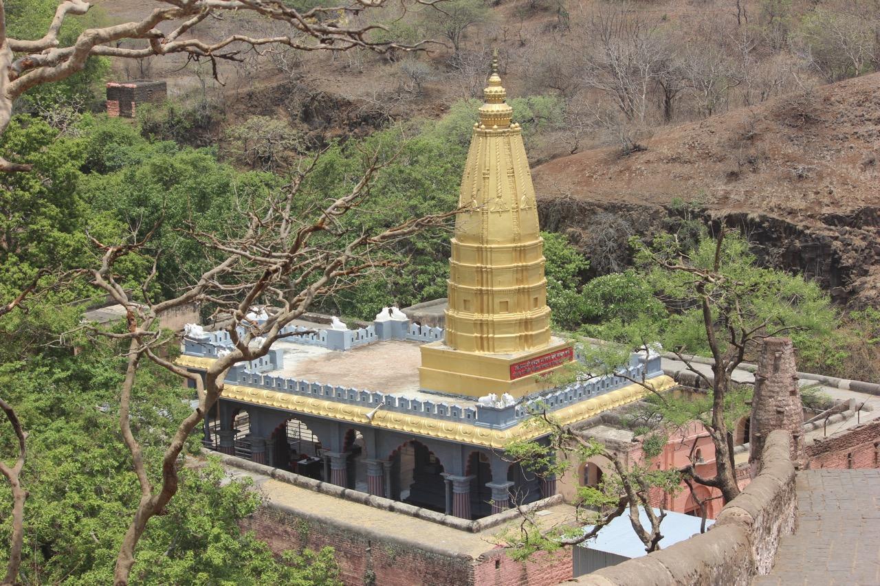
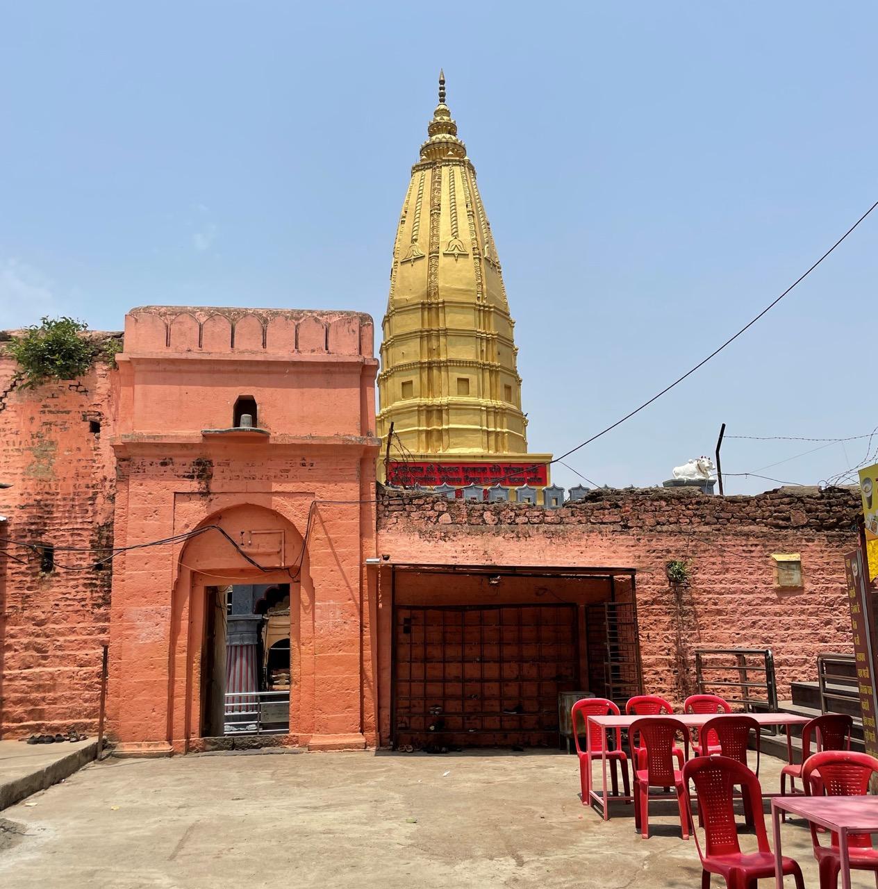
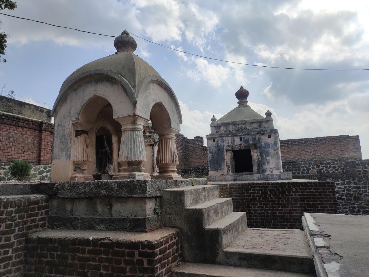
Sant Goroba Kaka Mandir
The Sant Goroba Kaka Mandir, located in Ter, was built in the 13th century in memory of Goroba Kaka, a poet, potter, and sant of the Bhakti movement. Born in 1267 CE, he is especially revered by the Kumbhar community.
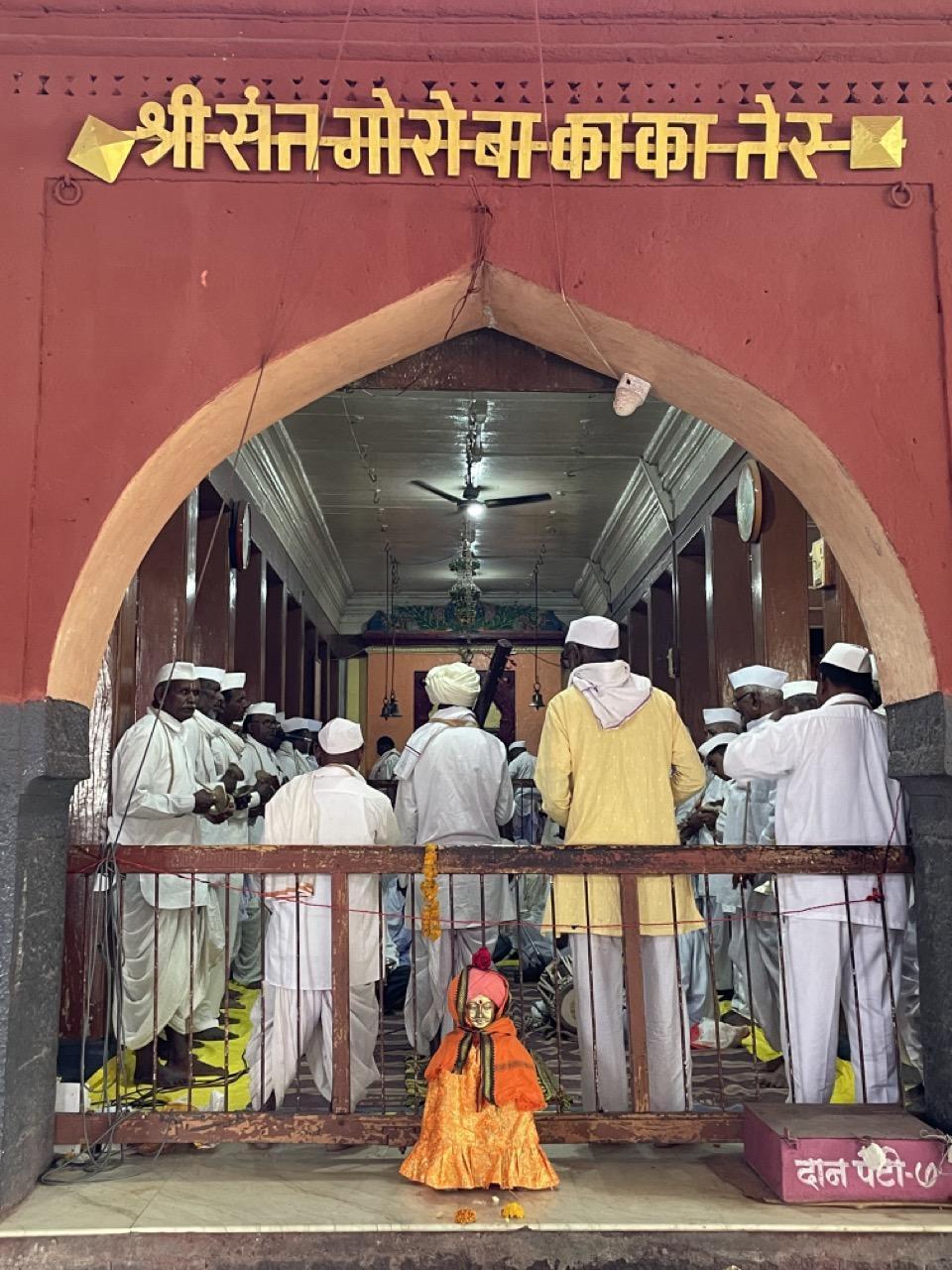
The Mandir stands close to the Terna River and is protected by a large stone wall built to prevent flooding. People often bathe in the river before entering as a form of ritual cleansing. Inside, a sabhamandap leads to the garbhagriha, where the samadhi of Goroba Kaka is placed beside the murtis of Vitthal and Rakhumai (another name for Rukmini, consort of Vitthal).
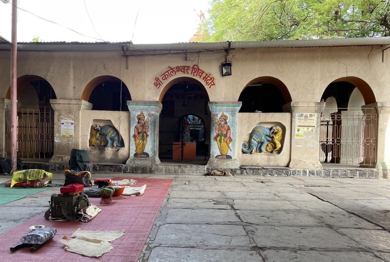
The Mandir also houses two additional spaces, one dedicated to Kaleshwar and the other to Nilkanteshwar. Morning aarti begins quite early in the morning, often continuing for several hours. Offerings made during the ritual include coconuts, sugar, cash, sweets, clothes, and clay pots (symbolic of the sant’s link to pottery).
The Mandir also observes several unique customs. A unique tradition at the Mandir is linked to the belief that Rakhumai “sleeps” on certain days of the year. During this time, the chhabina (procession) is not held. Instead, offerings of infant hair and flower garments are brought to seek her blessings.
Shiv Mandir, Mankeshwar
The Shiv Mandir at Mankeshwar is located on the banks of the Vishwakarma River in Dharashiv. Built in the Hemadpanthi style, the structure is carved from a single block of black stone and follows a star-shaped layout. At the centre is a sabhamandap supported by four intricately carved pillars, featuring lotus motifs and carvings of Nataraj Shiv (cosmic dancer form of Shiv).
The Mandir remains actively connected to local ritual life. A devasthan within the complex is dedicated to Satwai Devi, where the jawal ritual continues to be observed. This marks the first haircut of baby boys, with a tuft of hair offered to the Devi. The ritual also involves an offering of male goat meat as part of a long-standing regional tradition seeking blessings for protection and well-being.
Interestingly, locals say that remnants of several small stone structures, partially buried, can be seen across the complex. These are believed to be remains of older mandirs, which, according to local accounts, were destroyed during the campaigns of Afzal Khan (17th-century general under the Bijapur Sultanate, known for his military expedition against Shivaji).
Shiv Mandir, Umarga
The Shiv Mandir in Umarga is believed to be nearly 1,000 years old. Built in the Hemadpanthi style, its features suggest links to the Chalukya, Silhara, and Rashtrakuta dynasties. The Mandir stands on raised ground, with its entrance marked by elephant carvings on the pillars.
Shri Mahalakshmi Mandir
Shri Mahalakshmi Mandir is located in the village of Jagji, approximately 30 km from Dharashiv city. The Mandir is dedicated to Devi Durga and is part of a larger mandir complex containing smaller mandirs devoted to various devis and devtas. Adjacent to the main Mandir is a stepwell, locally known as Lakshmitirth.

Sonari Mandir
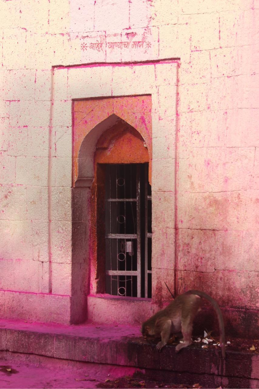
Sonari Mandir is located in Paranda taluka and is dedicated to Sonari Devi, considered an incarnation of Durga. The Mandir is also associated with Bhairavnath, the chief of the Ashta Bhairavs, and is believed by locals to be around 1,200 years old. Remarkably, locals say that Sonari is one of only two mandirs dedicated to Bhairavnath, the other believed to be in present-day Pakistan.
Legends and Local Belief
As peculiar as this might sound, the site is known for its resident monkeys, who, according to local stories, were brought here long ago to protect the Mandir. Despite repeated efforts to remove them, they’ve stayed and are now seen as guardians of the space.
Interestingly, this idea of protection also appears in stories about how the Mandir came to be. Locals say the area was once known as Suyar (Surya) Nagari, a forested region inhabited by rakshasas. One of them, Varnasur, had a boon: he couldn’t be killed by a celibate, and if he died, more rakshasas would be born from his blood.
Bhairavnath, then living in Khandari, a village four km away, is believed to have defeated Varnasur, but only with the help of Sonari Devi, who is worshipped at the site as a form of Durga. Some say the name "Sonari" comes from this story.
Rituals and Offerings
Ritual offerings to Bhairavnath typically include gulaal (coloured powder) and sugar, while Sonari Devi is offered turmeric, roti, jaggery, khoya, and flowers. Coconut shells smeared with gulaal and puran poli (a sweet flatbread) are also commonly placed near the devasthan. The ritual use of gulaal is linked to local beliefs that Bhairavnath favoured it.

Festivals and Agricultural Significance
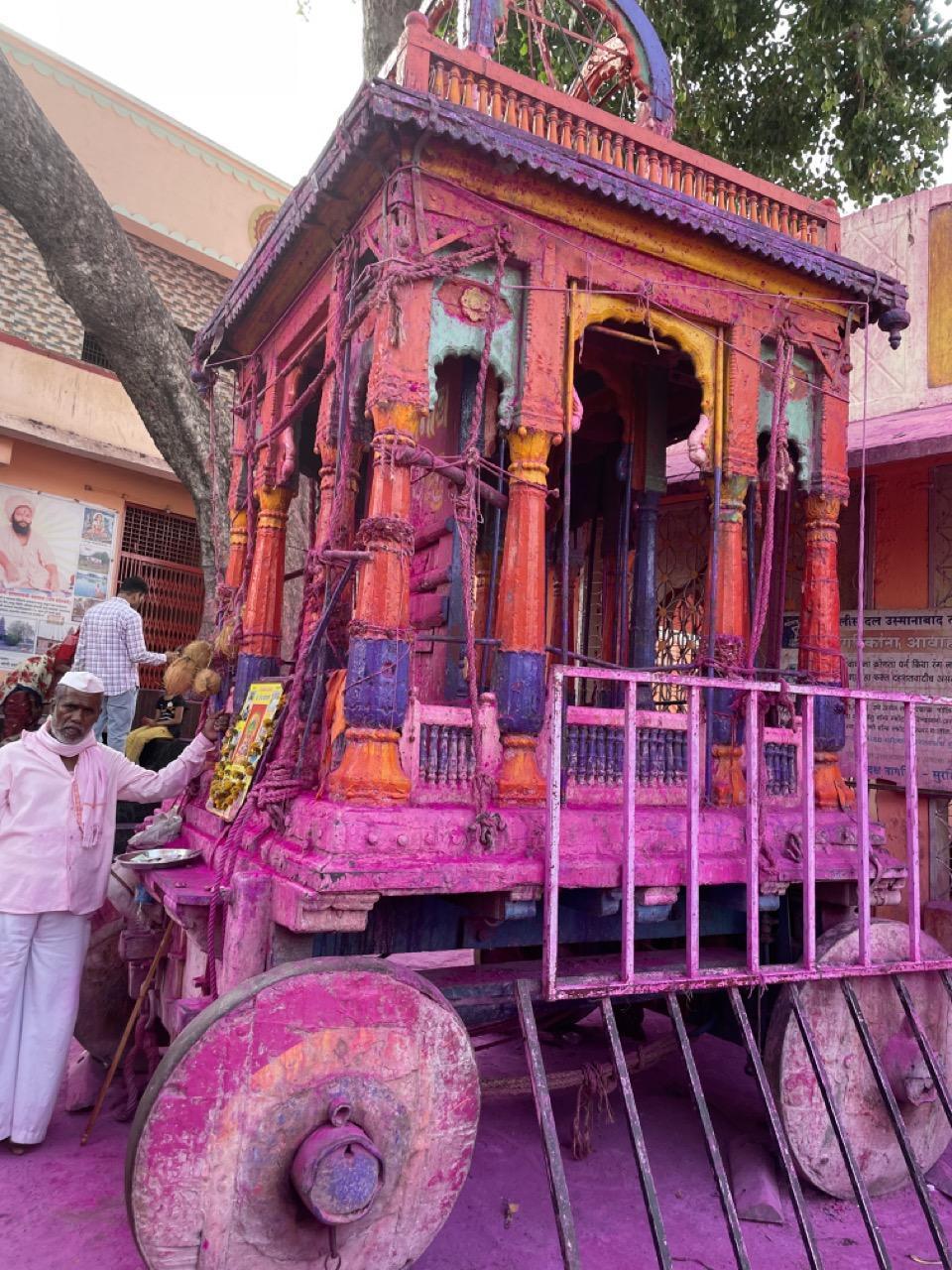
The Kandari festival is a major annual event associated with the Mandir. During the festival, people participate in a kavade palkhi, carrying pots that are immersed in a well within the Mandir grounds. The act is believed to purify the space and remove negative energy.
The Mandir is also tied to agricultural cycles. Every twelve years, a Maharaj from Kashi is said to visit the site, bringing a special type of water believed to benefit local irrigation. During Shravan (July–August), farmers from across the region such as Sangli, Kolhapur, Bijapur, Pune, Latur, and Belgaum, gather at the Mandir to pray for good rainfall and a successful harvest. The associated festivities typically last for seven days.
Land Ownership and Maintenance
The Mandir trust holds approximately 700 acres of land, some of which is considered ancestral. Each year, portions of this land are leased to local farmers through an auction system. Revenue from the leases is used for the maintenance of the Mandir and its associated rituals. The arrangement has created a close relationship between the Mandir and the local agricultural economy.
Ter
Dharashiv’s historical significance stretches back centuries, and one of the places where that history is most visible is the small village of Ter. In ancient times, what is now a quiet settlement was once a thriving trade centre with links that extended as far as Rome.

In recent years, Ter has become an increasingly important site for archaeologists and historians. It has been mentioned in the Periplus of the Erythraean Sea (1st-century Greco-Roman trade manual) as a major inland trading center alongside Pratisthana (historic city, modern-day Paithan in Chhatrapati Sambhajinagar district). Its role in early trade networks is described in the district Gazetteer (1972), where it is noted that "its antiquity can be traced as far back as the Puranas wherein it is referred to as Satyapuri and in the ancient period of our history as Tagarnagar…The Periplus states that all kinds of mercantile goods throughout Deccan were brought to Tagara and from there conveyed in carts to Broach. It traded with the outside world, especially Greece and Rome, and some Roman coins recently discovered here lend testimony to this fact."
The Gazetteer (1972) also notes that Ter reached the peak of its prosperity during the Satavahana period (early Deccan dynasty, 1st century BCE–3rd century CE). It later became the capital of a branch of the Shilaharas (medieval ruling dynasty, 8th–13th century), whose seals and coins have been found in the area. These coins often feature an image of Mahalaksmi (the Devi of wealth and their kuldevi) being bathed by elephants.
The findings shed light on trade networks, material culture, and aspects of everyday life during that period. These sources provide evidence of the village's key role in ancient trade networks and its cultural importance, reinforcing its place in the broader context of long-distance trade and interaction during that era.
History of Ter
Before the rise of empires known today, it is believed that the region now known as Ter was part of the Janapada system, the territories or republics mentioned in Vedic texts. The Janapadas were crucial in shaping the political and social structures of early India. In the era of the Ramayan, Ter was believed to be part of the Dandakarya Forest, a region that served as the home of rakshasas.
The rise of the Satavahana dynasty (early Deccan rulers, 1st century BCE–3rd century CE) contributed significantly to Ter’s development as a major trading center. The settlement is believed to have reached its peak of prosperity during this period, supported by expanding territorial control and increased commercial activity. A local legend symbolizing this reach describes a Satavahana king’s horse drinking from all the great rivers of India, an image meant to represent the vast extent of the dynasty’s influence and its integration into major trade routes.
Ter’s location in the Deccan made it a key stop along inland trade corridors connecting coastal ports to interior markets. Trade routes running through Ter linked the Indian Ocean with the Mediterranean world. Merchants travelling from Bharuch (Gujarat) to Rome would pass through Paithan to obtain silk goods and through Ter for cotton and jowar (sorghum), both of which were cultivated in the region. These goods formed part of a larger exchange network that connected South Asia with the western world.
The evidence of Ter’s commercial and cultural importance has been uncovered through extensive archaeological efforts. Numerous coins from the Satavahana period, as well as inscriptions written in Brahmi script, have been found in the area, confirming Ter’s role as a key trade hub. Symbols of elephants and corn, found on some of these coins, hint at the importance of agriculture and animal trade during the time.
The reasons for Ter’s decline remain unclear. While local legends speak of natural disasters such as flooding or shifts in climate, there is no definitive evidence explaining why the once-thriving trade center lost its prominence.
Etymology of Ter
The origin of the name Ter is a subject of much debate, and several theories exist regarding its etymology. According to some accounts, the name of the region shifted from Tagar to Ter and then back again. The term Tagar was historically used to refer to a larger region encompassing Devgarh, Junnar, and Gulbarga. However, the specifics of this name transition remain unclear, and there is ongoing scholarly debate about the true origins of the name.
One theory proposes that Ter is derived from Ther, a Buddhist guru associated with the Hinyapant sect, as the region is home to numerous Buddhist mandirs, though no Buddhist murtis have been found within them. Alternatively, some sources suggest that the name originates from the Marathi word tervah, meaning the 13th village. According to this story, the local Patil (headman) managed 12 villages but was unable to control the 13th, which led to the area being referred to as Ter.
Additionally, Ner, meaning "town" or "city" in Marathi, could indicate that the region was originally known as Tagar Ner, which gradually evolved into Ter. Over time, the area has been known by a variety of names, including Tagar, Satpure, Tagarnagar, Terapur, and finally, Ter.
Although the etymology of the name remains a complex subject of study, it reflects the rich and multifaceted history of this ancient settlement. Fortunately, this lesser-known history is now preserved and displayed within the walls of a local museum named the K. Ramling Appa Lamture Shasakiya Vastusangrahalay, creating a space for its continued recognition and appreciation.
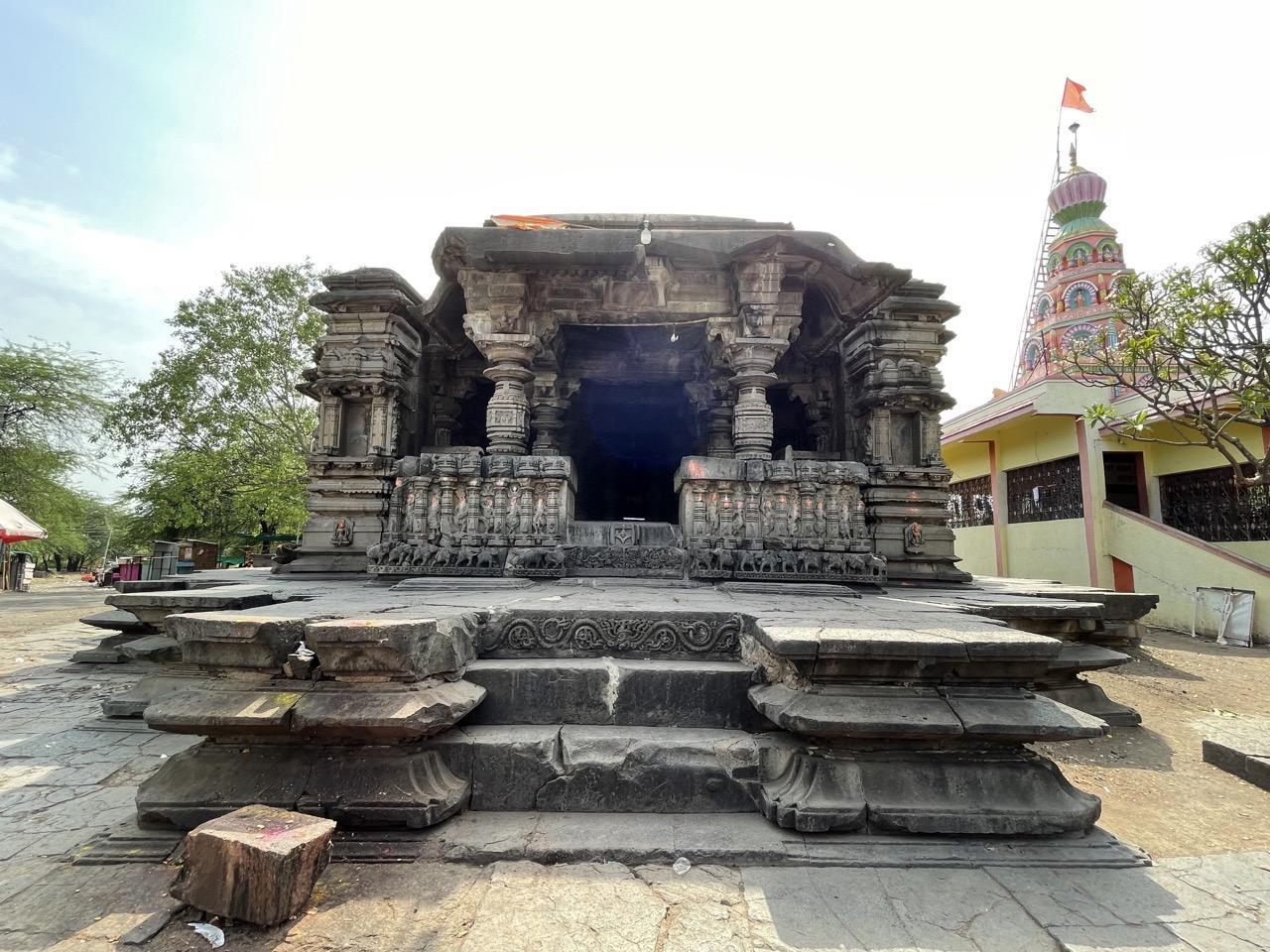
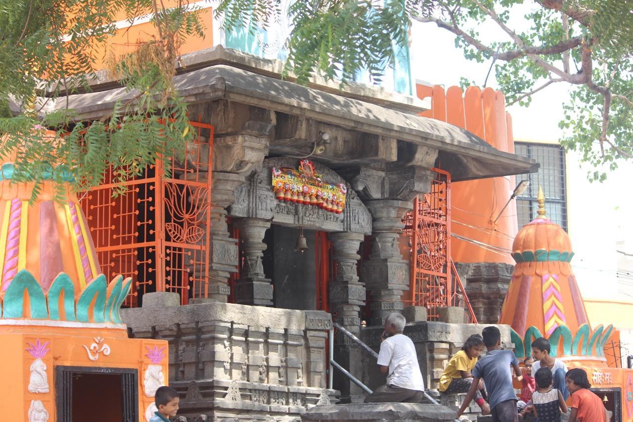
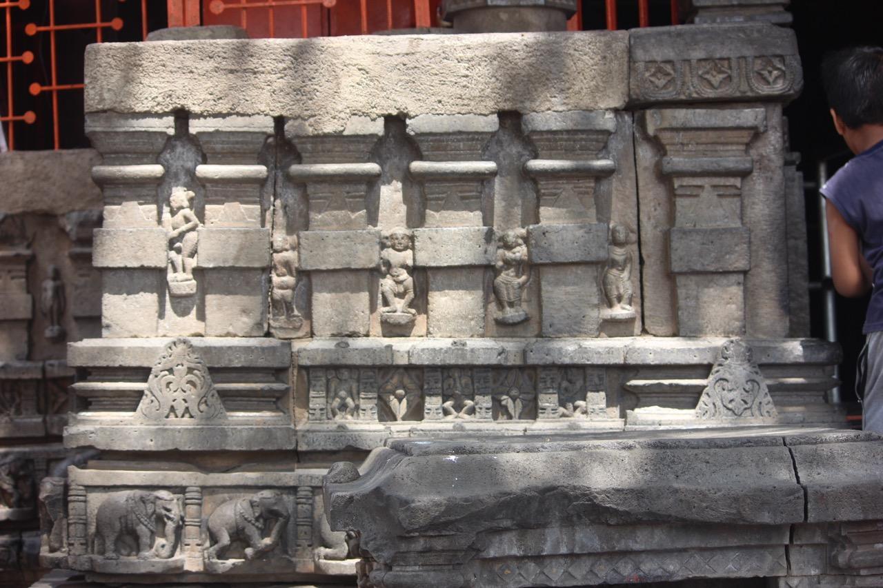
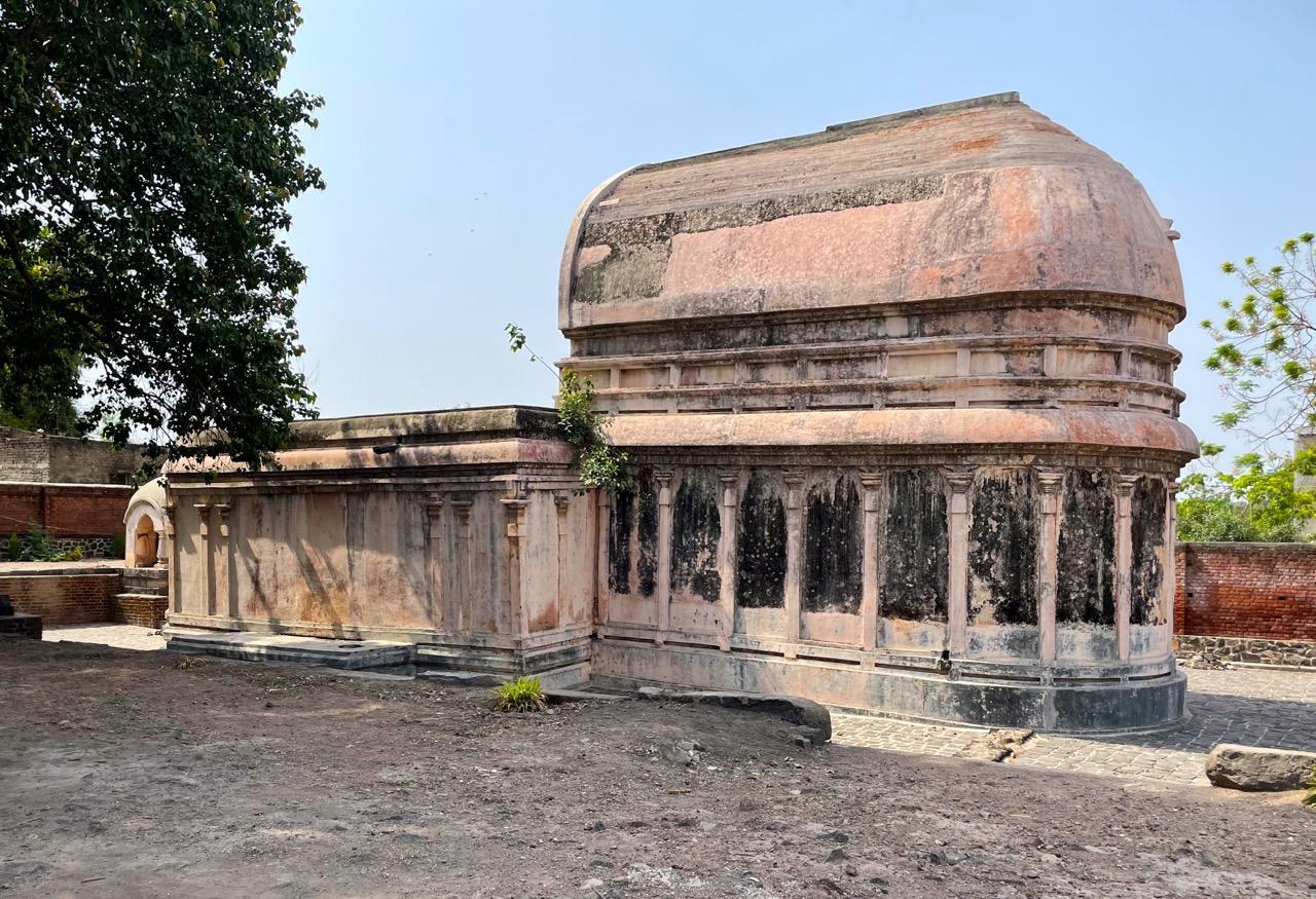
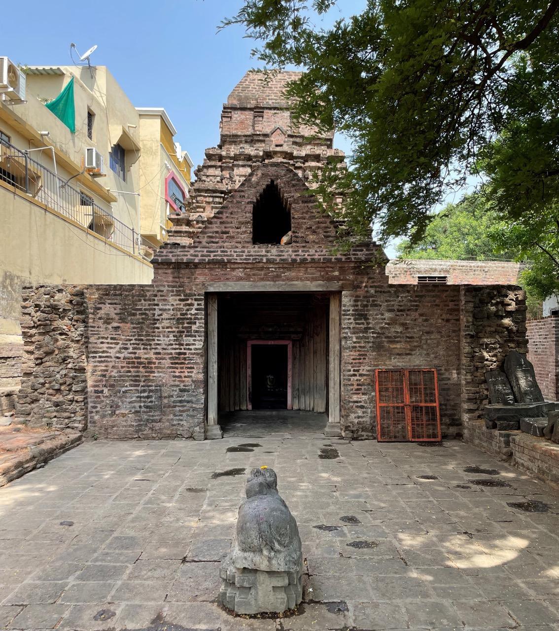
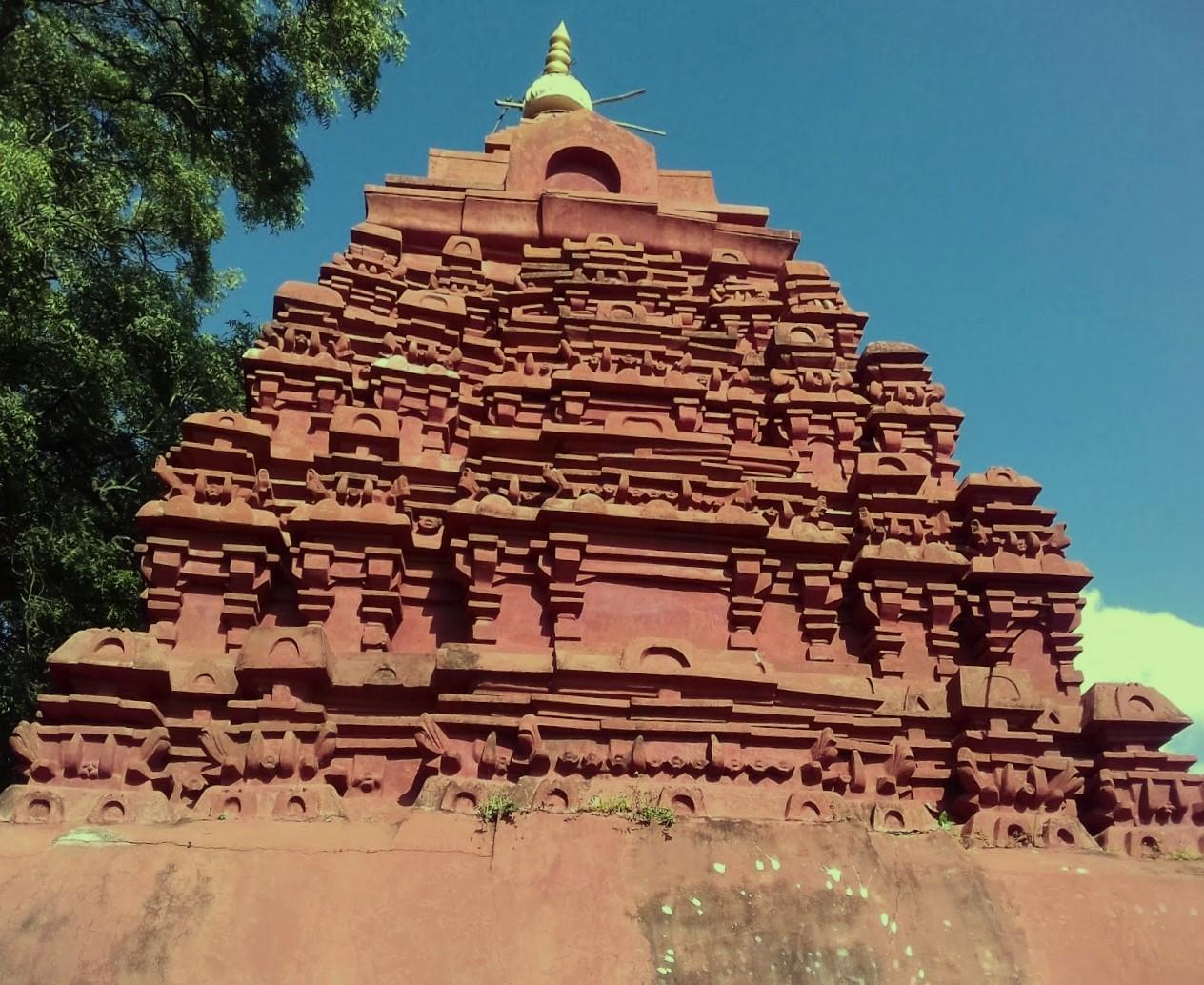
Trivikrama Mandir
Trivikrama Mandir, often referred to as the “brick mandir” of Maharashtra, is located in Ter, Dharashiv district. At present, the Mandir is dedicated to Devta Vaman (a form of Bhagwaan Vishnu). The building is believed to have been constructed around the 3rd or 4th century CE, possibly during the Satavahana period.
Notably, a Loksatta (2024) article notes that the site also served as the venue for the first Sant Sammelan, a significant religious gathering in the region.According to the account, prominent sants such as Namdev, Dnyaneshwar, Muktabai, Sopandev, Nivruttinath, and Gora Kumbhar are believed to have been present, adding to the site’s cultural and historical importance.
The religious and historical origins of Trivikram Mandir have been interpreted differently by various scholars. Archaeologist Henry Cousens suggested that the structure may have originally been a Buddhist Chaityagriha, citing architectural features such as an apse-like dome at the rear and an arched entrance reminiscent of rock-cut Buddhist chaityagrihas. Other scholars, including Smith, Fergusson, and M. S. Amte, have offered alternative interpretations and questioned the Buddhist-origin theory.

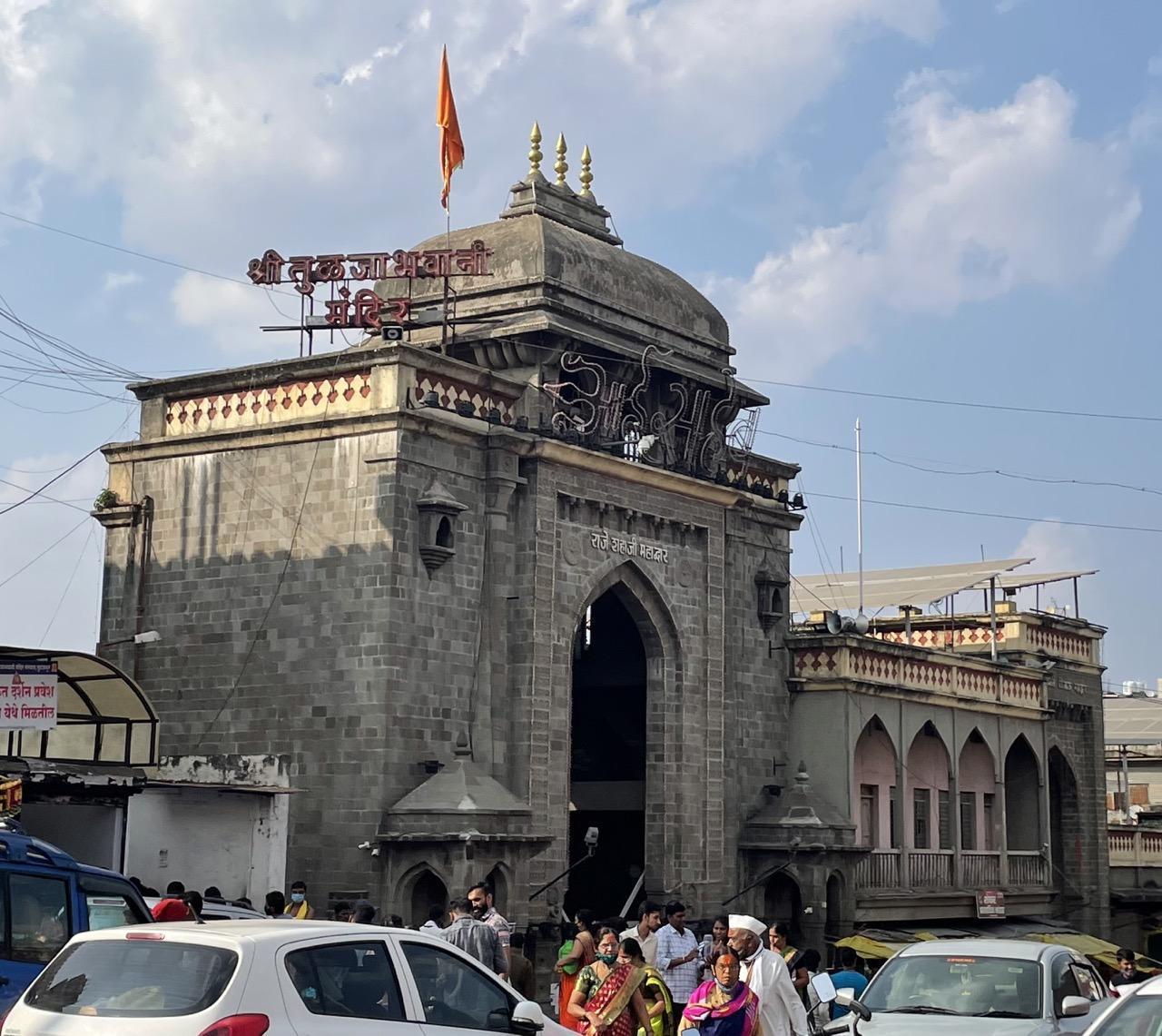
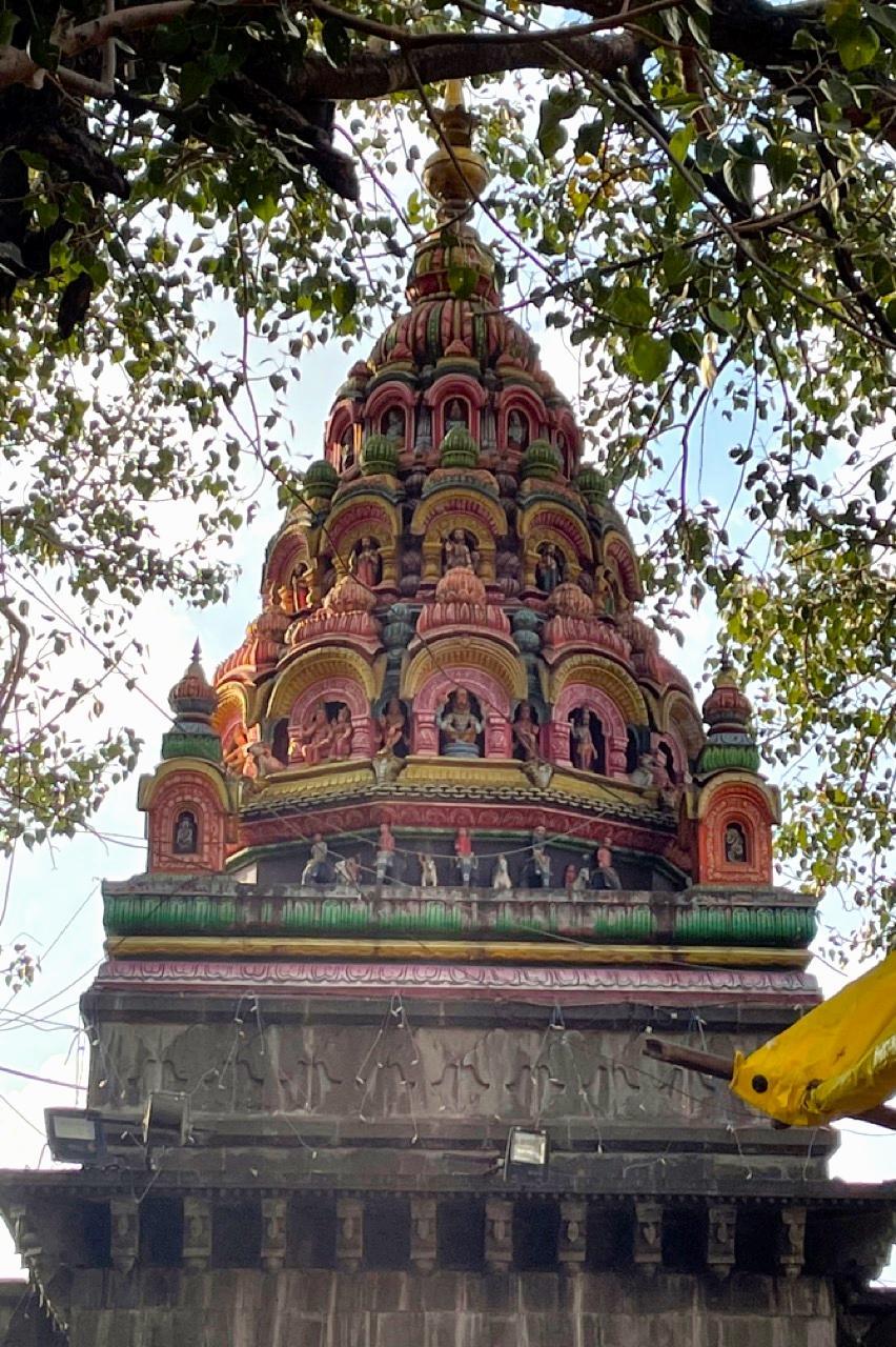
Tulja Bhavani Mandir
The Tulja Bhavani Mandir, located in the town of Tuljapur on the slopes of the Balaghat range in Maharashtra, is a significant religious site. The Mandir has long held an important place in the religious, cultural, and political landscape of the region. It is dedicated to Devi Bhavani, who is regarded as a fierce form of the Devi Durga and is deeply venerated across the region. The Mandir is among one of the four major Shaktipeeths in Maharashtra.

It is traditionally believed to have been constructed in the 12th century CE by a Maratha figure named Mahamandaleshwar Maraddev (Mahadev) Kadamb. The Mandir is still managed by the descendants of the Kadamb Bhope clan, who are entrusted with its upkeep.
Legends Surrounding Tulja Bhavani Mandir & the Devi
There are many legends that are tied to the manifestation of the Devi at Tuljapur. According to one account, as mentioned in the district Gazetteer (1972), a Rishi named Kardam once lived with his wife Anubhuthi and their young child near the banks of the Mandakini River. After Kardam's passing, Anubhuthi, left alone, is said to have begun a fierce penance, calling upon a divine force to protect her son. As she meditated, deep in the forested hills, a rakshas named Kukur appeared and began to torment her, seeking to disrupt her devotion.
It was then that the Devi is believed to have emerged, powerful and unyielding. She struck down the Rakshas and, at Anubhuthi’s request, chose to remain on the hill as a guardian and mother to all who sought her protection. From that moment on, she came to be known as the Bhavani of Tuljapur or Tulja Bhavani.
Another account, which also links the Devi to the site of the Mandir, describes her encounter with a rakshas who had taken the form of a buffalo, Mahishasur. After defeating him, the Devi is believed to have taken shelter on Yamunachala hill, part of the Balaghat range, where the present-day mandir now stands.
Tulja Bhavani Devi was the kulswamini of the Maratha rulers, especially Chhatrapati Shivaji Maharaj, the founder of the Maratha Empire. According to local tradition, Shivaji received the Bhavani Talwar, a divine sword, from the Devi. This act is viewed as a blessing to support his efforts in establishing swarajya (self-rule) and facing military challenges. The Bhavani Talwar came to represent Shivaji’s authority and the idea of divine support for his rule. As a result, the Mandir came to be seen as both a place of worship and a symbol of Maratha power.
Architecture & Layout
Tulja Bhavani mandir is situated on a fortified hill in Tuljapur and is built in the traditional medieval architectural style. The main entrance to the complex is the Nimbalkar Sardar Gate, with two additional entrances named after Shahaji and Jijabai, the parents of Chhatrapati Shivaji Maharaj. These architectural features reflect the Mandir’s historical association with the Maratha dynasty.
The Mandir complex houses several shrines, including one dedicated to Markandeya Rishi (a revered sage mentioned in the Mahabharat and Puranas, known for his devotion to Shiv and miraculous survival from death). Other important mandirs within the premises are Siddhi Vinayak (a form of Ganesh associated with success and wisdom), Aadishakti Matangadevi (a manifestation of the primordial feminine power), Annapurna (the Devi of food and nourishment, worshipped as a form of Parvati), and Datta Mandir (dedicated to Bhagwan Dattatreya). Notably, the Mandir also contains two libraries that preserve ancient manuscripts and sacred texts.
There is a large stone tank called the ‘Kallola Tirth’ inside the Tulja Bhavani Mandir complex, built in the 14th century. It is considered to be so sacred that many bhakts bathe in its waters before visiting the Mandir. Interestingly, local legends surrounding it link its water to the Ganga and attribute its construction to Bhagwaan Brahma. Additionally, various diseases are also believed to be cured by its water.
Rituals & Ceremonies
The mandir is also the site of several rituals and ceremonies. Every year, a grand jatra is held, drawing thousands of people. After visiting the Devi in the Mandir, a Jagran-Gondhal ceremony takes place, where prayers are sung to honor her.
A Yadnya (ritual fire sacrifice) is also conducted, invoking peace, prosperity, and well-being for all participating. During this period, an Abhishek (ritual bathing of the deity) is performed, and offerings such as a sari and a coconut are made to the goddess.
A traditional goat sacrifice is sometimes performed at the Mandir to appease the rakshasa Mahishasura, whom the Devi is said to have defeated. The sacrifice is carried out by people from the Mahar community, following an age-old custom.
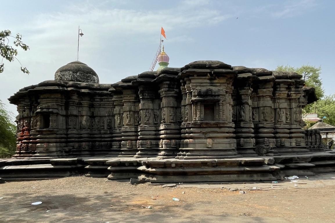
Uttareshwar Mandir
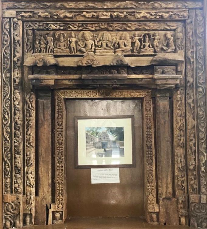
Uttareshwar mandir is located in the village of Ter in Dharashiv district. Dedicated to Bhagwaan Shiv, the structure is believed to date to the 5th or 6th century CE. It is constructed primarily of brick, with wooden elements, and features floral decorative motifs on its exterior.
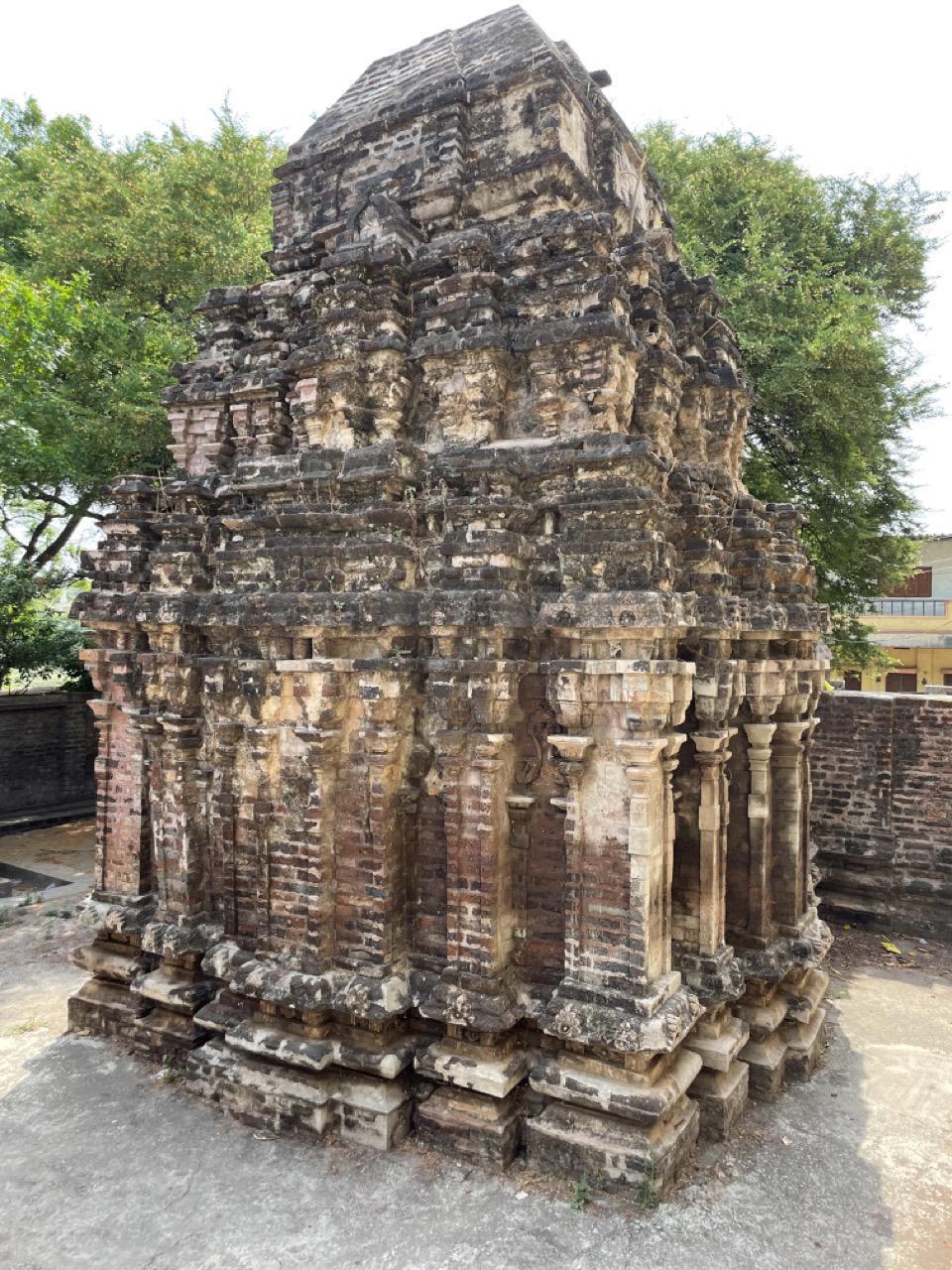
Its original door frame, now housed in the K. Ramling Appa Lamture Shasakiya Vastusangrahalay, is thought to show early influences that later became characteristic of Chalukyan architecture in the Deccan region.
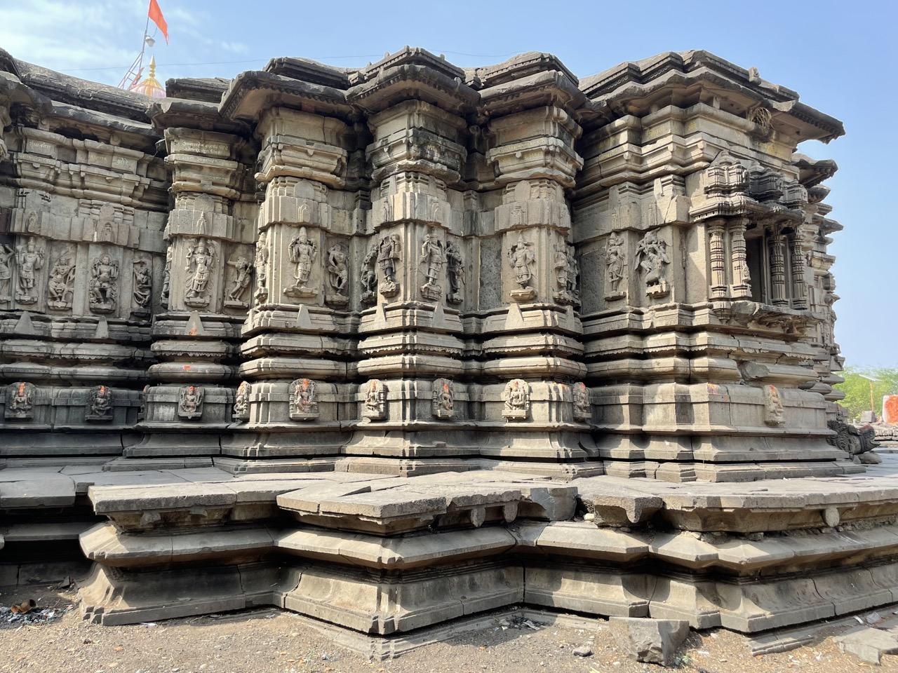
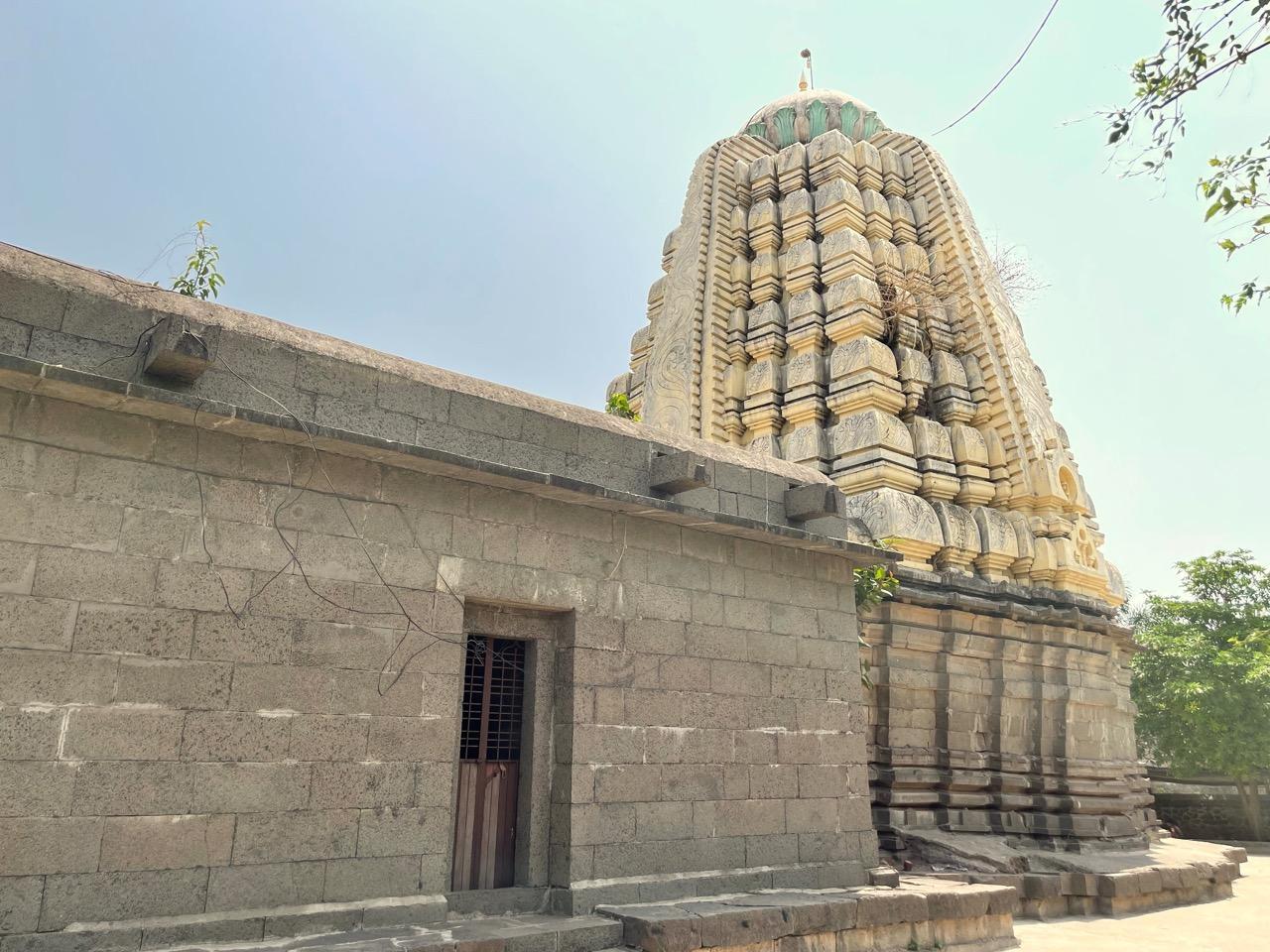
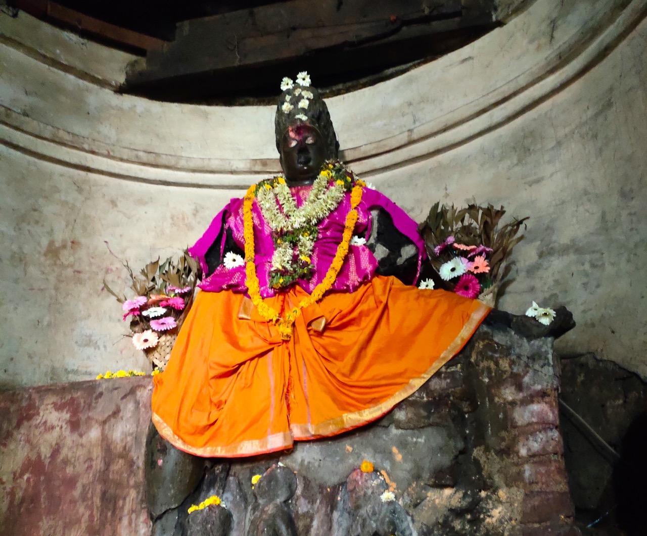
Kaleshwar Mandir
Kaleshwar mandir is an early medieval structure located on the banks of the Terna River in Ter, Dharashiv district. The mandir is believed to have been constructed in the 7th century CE and shares architectural similarities with the nearby Uttareshwar mandir.
While the mandir is primarily dedicated to Bhagwaan Vishnu, indicated by the presence of a Garuda image at the entrance, it also features a Shivling within the complex. One of the notable sculptures found at the site depicts a lion slaying an elephant.
Yedeshwari Mandir
Yedeshwari mandir is located on a hill in Dharashiv and is dedicated to Yedeshwari Devi, who is believed by many to be the younger sister of Tuljabhavani Devi. The mandir is known for its connection to a local retelling of the Ramayan.
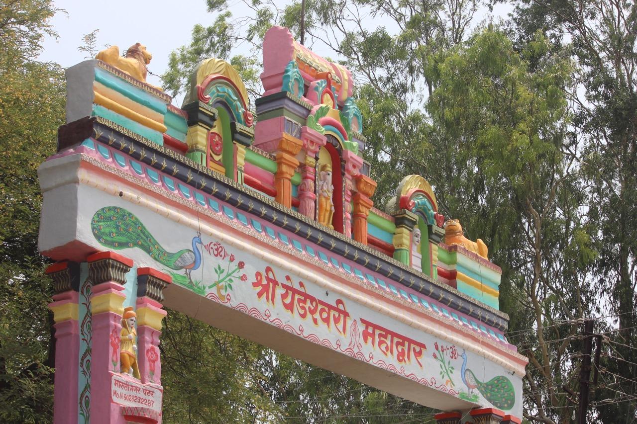
According to a legend recorded in the district Gazetteer (1972), during Bhagwaan Ram’s exile, Parvati took the form of Sita and tried to approach him. On recognizing her, Ram called out, “Oh! Crazy Mother! Why are you following me? Please leave me alone,” and referred to her as “yedai” (crazy). Over time, this name became associated with the Devi worshipped here, now known as Yedeshwari.
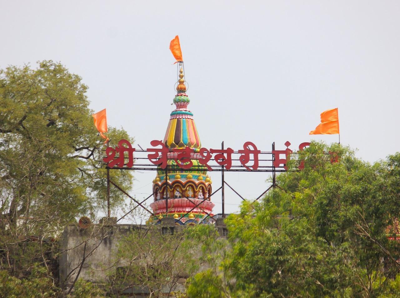
The mandir is built in the Hemadpanthi style and reached by climbing around 200 steps. The black stone image of the Devi is housed in the garbhagriha, marked with kumkum on the forehead and silver detailing on the eyes and mouth. The mandap features a brass prabhaval, and the mandir is accessed through two entrances. Offerings made to the Devi include coconuts, sweets, jaggery, sugar, sarees, and jewelry.
Two annual fairs are held here: one on Chaitra Purnima (full moon in March–April), and the other on Shravan Purnima (full moon in July–August). Both involve processions and large gatherings, with stalls and offerings set up throughout the Mandir grounds.
Sources
Akshardhool Stories. The Ancient Trade Hub of Tagar – Part I. Akshardhool Stories.https://akshardhoolstories.blogspot.com/p/th…
Chavan, A. 2018. The Goddess Who Went to Nepal. Live History India.https://www.livehistoryindia.com/
Devdutt Pattanaik. 2003. Indian Mythology: Tales, Symbols and Rituals from the Heart of the Indian Subcontinent. Inner Traditions, Vermont.
Dhaval Kulkarni. 2018. DNA Exclusive: Khichdi Was Around Even 2,000 Years Ago, Says Study. DNA India.https://www.dnaindia.com/india/report-dna-ex…
Durgbharari. Naldurg. Durgbharari.https://durgbharari.in/naldurg/
Heritage India Admin. 2022. Revisiting the Golden Era. Heritage India.
Hindu Temple Organization. Makar Sankranti. Hindu Temple Organization.
Jain Mandir Organization. Shri Digamber Jain Siddha Kshetra Kunthalgiri, District – Osmanabad (Maharashtra). Jain Mandir Organization..https://www.jainmandir.org/Temple/Shri-Digam…
Kelkar, A., and Bhave, S. 1988. The Experience of Hinduism: Essays on Religion in Maharashtra. SUNY Press, New York.
Loksatta. 2024. Come to Ter to See the Temple of One and a Half Thousand Years Ago – The 4th Century Trivikram Temple Will Get Its Past Glory. Loksatta, Maharashtra.https://www.loksatta.com/maharashtra/dharash…
M.S. Mate. 1957. The Trivikrama Temple at Ter. Bulletin of the Deccan College Post-Graduate and Research Institute, Vol. 18, Taraporewala Memorial Volume.
Maharashtra District Gazetteers. 1972. Osmanabad District. Government of Maharashtra.
Navanath Shinde. 2019. Yedeshwari. Marathi Vishwakosh.https://marathivishwakosh.org/17554/
Shaan e wali Karamaate Auliya. 2021. Baba Farid Shankar Ganj ka Kadimi Chilla Mubarak Pahado ki Wadiyo Main. YouTube.https://www.youtube.com/
Sunita Bant Pansal. 2008. Hindu Pilgrimage: A Journey Through the Holy Places of Hindus All Over India. Hindology Books, Pustak Mahal, Delhi.
Swati Goel Sharma and Mayur Bhonsale. 2023. The Mother and the Sword: A Visit to Tulja Bhavani Temple in Maharashtra. Swarajya.https://swarajyamag.com/culture/the-mother-a…
ThePrint. 2022. Dharashiv: New Name for Osmanabad Dates Back to Eighth Century, Expert. ThePrint, India.https://theprint.in/india/dharashiv-new-name…
Travlogger Team. 2018. Hazrat Khwaja Sheikh Farid Shakarganj Gad Sharif, Osmanabad (Gad Sharif Osmanabad). Travlogger.
Tuljabhavani.in. Official Website. www.tuljabhavani.in
Wikimapia. 2011. Gad Peer Baba Dargah, Osmanabad. Wikimapia.https://wikimapia.org/
Wikiwand. Osmanabad. Wikiwand.https://www.wikiwand.com/en/Osmanabad
Last updated on 3 November 2025. Help us improve the information on this page by clicking on suggest edits or writing to us.