Contents
- Etymology
- Ancient Period
- Microlithic & Savalda Culture Settlements at Prakasha
- The King of Toranmal
- Political Shifts in the Deccan Region
- Nandagiri Inscription at Kanheri
- The Abhiras & their Feudatories
- Elauri in a Land Grant Issued by the Rashtrakutas
- Local Rulers in and around Nandurbar in the 9th–12th centuries
- Medieval Period
- Farooqi Dynasty and the Khandesh Sultanate
- Mughal Rule and Economic Prosperity
- Akrani Mahal & the Rajputs
- Marathas & their Internal Conflicts
- Colonial Period
- Bhil Agencies and the Question of Settlement
- Resistance and Continued Operations in Nandurbar
- Education and Early Infrastructural Development
- Administrative Realignment and the West Khandesh District
- Nationalist Currents in Nandurbar
- Quit India Movement and the Martyrs Memorial
- Post-Independence
- Indigenous Communities and Cultural Identity
- Political Representation and Electoral Significance
- Sources
NANDURBAR
History
Last updated on 5 November 2025. Help us improve the information on this page by clicking on suggest edits or writing to us.
Nandurbar is among the relatively new districts that were formed in Maharashtra several years after the State was reorganized and formed. It was carved out from the Dhule district on 1 July 1998, as a separate administrative unit. Its history is deeply intertwined with Dhule and the wider Khandesh region to which it belongs. Yet, there are many noteworthy aspects that make the district stand out.
For one, traces of the Savalda culture have been unearthed here, which indicates that its history stretches back to prehistoric times. Other than that, stories of many mysterious figures in history, such as King Nandaraja and Akrani, who is believed to be the sister of Maharana Pratap, are tied to the district. The Bhils and many other indigenous communities make up a major part of the district’s populace and have resided here for many generations. Remarkably, many moments in Nandurbar’s history, both social and political, are closely tied to these communities.
Etymology
The name of the district, as with many places in this part of the Deccan, has undergone several changes in accordance with the prevailing political powers of different periods. Interestingly, according to local accounts, the present name Nandurbar is said to derive from a ruler known as Nandaraja; of this figure, however, little is known. However, another theory tied to the origins of the district’s name suggests that it was derived from the word “Nandar,” which is said to refer to a marketplace for agricultural goods.
In ancient times, the region was believed to have been part of a larger territory known as Rasika. This name appears in the Mahabharat, where it is mentioned alongside other prominent regions such as Mahisaka (associated with present-day Mysore) and Vidarbha, suggesting its early cultural significance.
Subsequently, during the reign of Seunachandra of the Yadava dynasty, the area came to be known as Seunadesa. This renaming likely reflects the growing administrative and territorial influence of the Yadavas on the district during that period.
Ancient Period
Over the course of history, the region now forming Nandurbar district has fallen under the influence of many different political and cultural powers. Little is currently known about its early history; however, archaeological remains and scattered references in literature offer some insights into the region’s past. These are better understood when placed in the context of Khandesh and the northwestern Deccan, to which Nandurbar has long been linked by geography, political influences, and culture.
Microlithic & Savalda Culture Settlements at Prakasha
Much of Nandurbar’s early history is known because of the discovery of artifacts from the prehistoric period at Prakasha, which lies on the banks of the Tapi River in Shahada taluka. The site was excavated by archaeologist B. K. Thapar, whose findings significantly contributed to the understanding of early habitation in this part of the Deccan.
Excavations revealed that the earliest settlers at Prakasha belonged to the microlithic period. While the use of copper was known to these communities, it appears to have been rare and not widely adopted in daily life. The material culture of this phase is marked by a distinctive ceramic tradition, primarily characterized by red-slipped pottery decorated with black-painted motifs. These designs included geometric patterns such as hatched diamonds, crisscross lines, oblique bands, and occasional depictions of animals.
Alongside the red ware, archaeologists also uncovered a finer variety of burnished grey pottery, some of which featured faint white linear designs. In addition to ceramics, other finds included beads made of shell-paste and semi-precious stones, pointing to a degree of artisanal activity and possibly trade interactions.
In 1955, further investigations by the Archaeological Survey of India brought to light artifacts associated with the Savalda cultural phase. This Chalcolithic culture, dated to approximately 2500–2000 BCE, represents an early agrarian tradition in the Deccan region. The presence of red-slipped pottery, microlithic tools, and domestic remains suggests that Prakasha supported a settled agricultural community during this period and marks it as a significant early habitation site within the Tapi valley.
The King of Toranmal
Toranmal, a region that is located in the Satpura range and lies within the present boundaries of Nandurbar district, is another significant site whose origins stretch back to antiquity. Fascinatingly, some of the earliest literary references known to the region are tied to Toranmal, and of all texts, it finds its mentions in the epic Mahabharat.
It has been noted in the Gazetteer of the Bombay Presidency: Khandesh (1880) that “the oldest Khándesh legends belong to the hill forts of Turanmál and Asírgad. The Mahabharat mentions Yuvanâshva, the ruler of Turanmál, as fighting with the Pandavas, and Asírgad as a place of worship of Ashvattháma.” Its mention in the text, in many ways, could point to its significance during that period.
Political Shifts in the Deccan Region
In the 3rd Century BCE, among the many dynasties that held sway over the Deccan region, such as the Mauryas under the reign of Emperor Ashoka. Inscriptions from the period suggest that the region could have been a part of the Mauryan Empire. Among them, Ashoka’s fifth and thirteenth rock edicts mention communities such as the Rashtrika Petenikas and Bhoj Petenikas, which are especially important. Scholarly interpretations suggest these groups were located in Pratisthana (present-day Paithan, Chhatrapati Sambhaji Nagar) and Vidarbha, respectively. Given Nandurbar’s geographical proximity to these regions, it is possible that the area came under their influence.
Following the Mauryan period, the Satavahana dynasty (1st century BCE to 3rd century CE) established its rule over large parts of the Deccan. The dynasty's territorial expansion under early rulers such as Satakarni I is believed to have extended up to the Narmada River, which flows through Nandurbar, placing Nandurbar within or adjacent to their northern frontier.
Nandagiri Inscription at Kanheri
More clear references to the political history of Nandurbar, which many scholars agree upon, appear in an inscription found at the Kanheri Caves (Mumbai Suburban district), dated to around the 3rd century CE. As mentioned above (in the etymology section), it is believed Nandurbar may have once been known as Nandigriha, and this older name finds its mention within the inscription. Although the inscription does not give precise geographic details, according to the Dhulia district Gazetteer (1974), many historians have identified Nandigriha, “with modern Nandurbar,” which is noted to have been “founded by Nand, a Gavali Raja and remained in the hands of his family till the advent of the Muslims…”
The identification of Nand as a “Gavali Raja” is very noteworthy here, as they hold a vital place in Maharashtra’s history. Although there are many debates surrounding their origins, it is said that they were primarily a pastoralist community and were closely related to the Ahirs (who are linked to the Abhiras). Both communities have long inhabited the Khandesh region and also held considerable political power.
The Abhiras & their Feudatories
Interestingly, R E Enthoven (1987) mentions that, “the name of the tribe…Ahir is a corruption of the Sanskrit Abhira." The historians of Alexander (B.C. 325) speak of one Abisares as the ruler of the hills between Murri and the Margala. It has been held by some that Abisares corresponds to Abhira, and that consequently the king Abisares, referred to by the Greek historians, denotes an Abhira chief.”
It has been recorded that following the decline of the Satavahanas, the Abhiras emerged as a major political force in the Khandesh and Vidarbha regions. Bhagwansingh Survavanshi (1962), of their emergence as a dynasty writes that “As a result of the dismemberment of the Satavahana empire, the local feudatories rose up in arms and proclaimed their independence.” Given their hold over the Khandesh region, it is thus very likely that many parts across Nandurbar fell within their influence.
One of the earliest documented Abhira rulers was Isvarasena, who established an era in 250 CE that later came to be known as the Kalachuri-Cedi era. Inscriptions marking this era have been found across northern Maharashtra, Gujarat, Vidarbha, and parts of central India, indicating that Isvarasena and his successors governed a substantial territory that spanned the western Deccan. It is noted in the Dhulia district Gazetteer (1974) that Isvarasena was succeeded by nine other rulers from the same family.
A significant early link between Nandurbar and this political landscape comes from a 4th-century copperplate grant found at Kalachala, near present-day Chhota Udaipur in Gujarat. The inscription records a local ruler named Isvararata, who governed portions of central Gujarat and Khandesh, and notably issued the grant from a place called Prakasa, almost certainly the modern village of Prakasha in Nandurbar district. This is the earliest datable epigraphic mention of a locality within the boundaries of present-day Nandurbar.
Isvararata is described in the inscription as ruling under the authority of a “lord paramount,” most likely a king of the Abhira dynasty. The issuance of the grant from here suggests that the locality held some official significance during his rule.
As time passed, control over the Deccan region was contested by the Kalachuri, Chalukyas, and Vakatakas. These shifting political dynamics could have possibly influenced the political landscape of Nandurbar.
Elauri in a Land Grant Issued by the Rashtrakutas
In the 8th century CE, the Rashtrakuta dynasty rose to prominence and played a significant role in reshaping the political landscape of the Deccan region. Their rule extended across much of Maharashtra, Karnataka, and Madhya Pradesh.
Notably, the presence of the Rashtrakutas in Nandurbar has been attested by the discovery of a copperplate grant dated to Saka 851 (929 CE) in Andura village in Akola district. This inscription records the donation of the village Elauri (modern Erali), located near the Nandurbar railway station, suggesting the district was part of Rashtrakuta-controlled territory during this period.
Local Rulers in and around Nandurbar in the 9th–12th centuries
Between the 9th and 12th centuries CE, many local chiefs are noted in the Gazetteer (1880) to have ruled over the Khandesh region, and their influence could have likely extended over parts of the Nandurbar district. Two important families who held much political power during this time were the Taks of Asirgarh and the Nikumbhavanashas of Patna (near Chalisgaon).
- The Taks controlled Asirgarh Fort (present-day Madhya Pradesh) and ruled from the early 800s to the late 1100s CE and were known for resisting early military advances of the Deccan Sultanate into the region. It is important to note that Nandurbar shares its borders with Madhya Pradesh, and hence, it is possible that, given their geographical proximity, they held some sway over parts of Nandurbar district.
- Further south, the Nikumbhavanasha family ruled from Patna (not to be confused with the city in Bihar) near Chalisgaon in Jalgaon district. According to historical records, they governed a large number of villages (more than 1,600), between 1000 and 1216 CE. Although there is no direct inscriptional evidence known yet that links them specifically to Nandurbar, their territory likely extended close to or possibly included parts of the district.
After 1216 CE, when the hold of Nikumbhavanashas dwindled, the Khandesh region (which possibly included Nandurbar) appears to have come under the Yadava dynasty of Devagiri (present-day Daulatabad).
By the 15th century, a group called the Chauhans is said to have arrived from Golkonda, replaced the Taks, and took control of areas in Khandesh. By the 15th century, ruling families like the Jadavraos may have ruled over what is now referred to as West Khandesh (which included present-day Nandurbar and Dhule).
Medieval Period
In 1295, Alauddin Khilji, then a general of the Delhi Sultanate, invaded Khandesh, defeating Ram Dev, a local Yadava ruler. Though Ram Dev retained nominal power as a tributary to Delhi, this independence was short-lived. By 1312, his son Shankal Dev failed to meet the tribute demands and was killed, marking the beginning of direct Sultanate control in the region. Devgiri (Daulatabad, Sambhaji Nagar district) became the Sultanate’s stronghold in the Deccan. Following Alauddin’s death, local unrest was subdued by the Delhi court. While much of the Deccan passed into the hands of the Bahmani Sultanate, the Khandesh region did not. Instead, it remained within a contested zone, subject to both Delhi influence and rising regional assertiveness.
A noteworthy observation from this era comes from Ibn Battuta, the Moroccan traveller, who visited the region in 1342 CE. He recorded Nandurbar as a settlement “inhabited by the Marathas,” a remark suggesting that localized and possibly semi-autonomous structures were already in place at that time In the latter half of the 14th century, the region saw the rise of an independent line of rulers with the formation of the Farooqi dynasty, which would go on to play a central role in the political development of Khandesh for over two centuries.
Farooqi Dynasty and the Khandesh Sultanate
The Farooqi dynasty ruled Khandesh as an independent Sultanate from 1382 until its annexation by the Mughals in 1601. Interestingly, the town of Nandurbar, situated on the northern frontier of Khandesh, assumed early importance during the rise of the Farooqi dynasty in the late 14th century. It is first mentioned in connection with the early campaigns of Malik-Ahmad Faruqi (Malik Raja), founder of the Farooqi dynasty.
In 1370 CE, Malik Raja is stated to have received a grant of territory in Khandesh from Firuz Shah Tughluq, Sultan of Delhi. Acting on this authority, he advanced into the region and occupied Nandurbar and Sultanpur, both situated near the frontier of Gujarat. His hold on the area was temporary, as Muzaffar Shah of Gujarat advanced against him, forcing a withdrawal. Malik Raja then established his position at Thalner (now in Dhule district).
By 1382, Malik Raja had consolidated control over central Khandesh and declared independence. This marked the beginning of the Farooqi rule. Thalner served as the capital and was later replaced by Burhanpur as the administrative centre. Though Nandurbar did not serve as a seat of government, it remained significant as a northern outpost and continued to be an area of military activity.
In 1429, the Chief of Jalvara, a political fugitive from Gujarat, plundered Nandurbar with the assistance of Malik Nasir Faruqi, indicating the town's continued exposure to conflict along the Gujarat frontier.
During the 16th century, Nandurbar again became a point of interest in regional affairs. In 1536, Muhammad Shah III of Gujarat, upon ascending the throne, transferred Nandurbar and Sultanpur to Mubarak Khan Faruqi, fulfilling a promise made during his confinement at Asirgad Fort. The towns were briefly taken by Changiz Khan of Gujarat after Muhammad Shah’s death, but were soon returned to Farooqi control. In 1601, during the Mughal annexation of Khandesh under Emperor Akbar, Nandurbar and Sultanpur were brought under direct Mughal authority.
Mughal Rule and Economic Prosperity
Following annexation, Nandurbar and Sultanpur were briefly transferred from Khandesh to the Malwa Subah, though this appears to have been temporary. The Ain-i-Akbari, compiled by Abul Fazl, records Nandurbar as a substantial revenue-generating unit, measuring 8,59,604 bighas (approximately 6,44,730 acres) and producing an annual revenue of 5,01,62,250 dams (currency used by the Mughal Suri empire). The area was noted for its fertility, especially for melons and grapes.
Economic documentation from the early 17th century provides further detail. In 1609 CE, Nandurbar was listed among the Khandesh towns engaged in the trade of “brass-ware, suits of armour, berries, drugs, pintados (printed calicoes), cotton yarn, wool, and coarse cloth.” By 1610, it was recorded as a town possessing “a castle, a pleasure house, and many tombs.”
The French traveler Jean-Baptiste Tavernier, who visited the region in the mid-17th century, described Nandurbar as “enjoying considerable prosperity” and praised the quality of its grapes and melons. By 1695, the town had grown to considerable wealth; one record notes that “without any general pillage, a sum of Rs. 17,00,000 was raised from the bankers alone.”
Akrani Mahal & the Rajputs
While Nandurbar was increasingly drawn into the administrative fold, a separate narrative unfolded in the Akrani hills, where a fort is said to have been established by Rajput settlers during the same period.
Known locally as Akrani Mahal, the site lies in the remote highlands of present-day Akrani taluka, within the Satpura mountain range. It is stated that, following the Battle of Haldighati in 1576, a conflict between Maharana Pratap and the forces of the Mughal emperor Akbar, Akkarani, accompanied by several Rajput retainers, migrated south and took refuge in the Akrani hills. The fort is believed to have been constructed during this period.
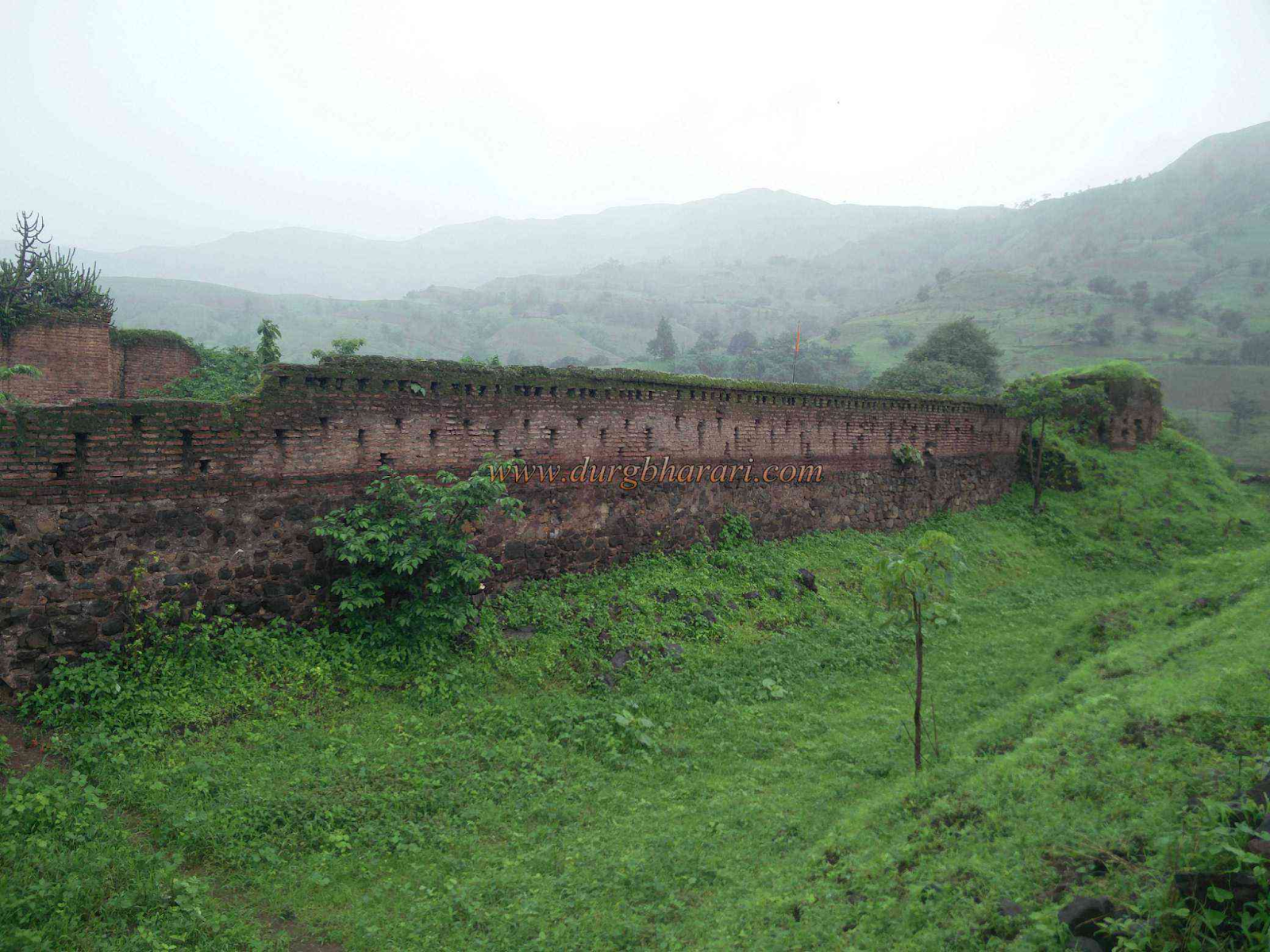
The structure occupies an area of approximately 2.5 acres and follows a rectangular plan. Remains include portions of outer walling, gateway entrances, and five memorial stones, which are believed locally to commemorate members of the early group. The fort does not appear to have served any administrative or military function under known regional powers, and its role appears to have been localised.
At present, Akrani Mahal is in a state of structural decline, owing to prolonged exposure and the absence of regular maintenance. Local organisations, including the Birsa Kranti Dal, have submitted representations for the fort’s preservation.
Marathas & their Internal Conflicts
From approximately 1670 onwards, the Marathas, under the leadership of Shivaji, began extending their influence into Khandesh, primarily through the collection of tribute and periodic raids. These incursions continued under his son, Sambhaji, and intensified after the death of Aurangzeb in 1707, which marked the beginning of a prolonged decline in Mughal authority. Following the death of Aurangzeb in 1707, the weakening of Mughal authority allowed the Marathas to establish firmer control. Over time, Khandesh became a contested area between the Maratha houses of Holkar, Scindia, and the Peshwa.
During the early 1700s, the region became a battleground between Maratha leaders and remaining Mughal commanders. One of the most prominent figures during this time was Chin Qilich Khan, later known as the Nizam-ul-Mulk and founder of the Hyderabad State. He seized control of Khandesh for a time but was eventually forced to negotiate with the rising Maratha powers. After his death, the Marathas expanded their control, and by the middle of the century, most of Khandesh, including Nandurbar, was under Maratha influence.
By this time, several Maratha factions (including the Holkars of Indore, Scindias of Gwalior, and the Peshwas based in Pune) competed for dominance in the region. This led to instability and frequent shifts in local control.
In the 1790s, a power struggle broke out within the Scindia family. The dispute, known in some accounts as the “Affair of the Ladies,” caused unrest around Pune and spread into Khandesh. According to the Dhulia Gazetteer (1974), by 1798, Nandurbar and the surrounding areas were affected by troop movements and conflict between rival factions.
Yeswantrao Holkar, a powerful general of the Holkar family, led several campaigns through Khandesh between 1799 and 1802. He passed through Sultanpur, Nandurbar, and nearby areas, plundering towns and recruiting support from the local Bhil communities, who were familiar with the forests and hills. His camp was based for a time at Thalner, and the surrounding region saw repeated disruption.
In one case, when a local leader in Sultanpur refused to support Holkar, the town was attacked. Other places, such as Raver (Jalgaon district) and Dhulia (now Dhule), also suffered during this time. Though Dhulia was briefly restored by Balaji Balvant, stability did not last.
Further damage came in 1816, when the Pindaris, a loosely organised group of raiders, entered the area. They caused widespread destruction before being pushed out in 1817 by a British force under Lieutenant Davies. Still, order in the region remained fragile. During these years, it is said that the Bhil communities, who had long served as village watchmen and lived in the forests, withdrew deeper into the Satpura hills. Many resisted outside control, whether from Maratha or British forces.
In June 1818, after defeating the Peshwa in the Third Anglo-Maratha War, the British took full control of Khandesh. From this point forward, Nandurbar became part of British-administered territory, marking the start of a new phase in the district’s history.
Colonial Period
Although most towns south of the Satpuda range had passed into British hands by March 1818, it is noted in the Dhulia Gazetteer (1974) that Sultanpur (Nandurbar district), Nandurbar (Nandurbar district), Adavad (Jalgaon district), and Raver (Jalgaon district) remained under Maratha control. British forces continued their advance, and by June 1818, Nandurbar was occupied by a detachment under Major Jardine.
Military action in the region followed a coordinated advance. Colonel MacGregor moved toward Sultanpur (Nandurbar district), while Major Innes advanced from Galna (Nashik district) to provide support. Earlier that April, Mir Fasat Ali, the jagirdar of Anturgad and Songir (both in Dhule district), had occupied Chalisgaon (Jalgaon district) and three other Peshwa-held towns. These were placed under Lieutenant Rule’s supervision. Around the same time, Arab mercenaries and Muvalads (Indian-born Arabs) had begun raiding the surrounding plains. To restore order, Mir Fasat Ali, backed by a British infantry battalion, two field guns, and cavalry, pushed into the area. Once secured, the territory was handed over to Lieutenant Hodges, the Assistant Political Agent.
By mid-1818, British authority over Khandesh had been largely established. However, administration remained tenuous, particularly in the hill regions inhabited by Bhil communities who retained a degree of independence and refused to submit easily to outside control.
Bhil Agencies and the Question of Settlement
Following the consolidation of British power in Khandesh after 1818, the colonial administration faced persistent resistance from Bhil communities, particularly in the forested and hilly tracts of the Satpuda ranges. These groups, long accustomed to autonomous life in the uplands, resisted direct governance and often engaged in raids on nearby villages.
In response perhaps, the Bombay Government in 1825 devised a new approach aimed at transforming the Bhils from what they described as “lawless tribes” into settled cultivators. To manage this transition, the government created three administrative units known as Bhil Agencies. Each was placed under a British officer and was tasked with managing local security, encouraging settlement, and fostering cooperation between the state and Bhil groups.
One of these, the north-western Bhil Agency, was headquartered at Nandurbar (present-day Nandurbar district). This agency oversaw the surrounding territory, including Sultanpur (Nandurbar district), Pimpalner (Dhule district), and parts of the Dang (Gujarat). Nandurbar's selection as a headquarters reflected its strategic location at the edge of the Satpudas, and its proximity to several key Bhil settlements. The officer in charge, known as the Bhil Agent, was responsible for restoring order in the region.
As part of this wider initiative, efforts were made to recruit Bhils into formal colonial service. At Dharangaon (Jalgaon district), Lieutenant James Outram was tasked with raising a Bhil Corps. Recruitment began slowly, largely due to long-standing mistrust between Bhils and state agents. However, Outram’s decision to engage directly with Bhil leaders, his informal style, and his reputation for fairness gradually earned their trust. By the end of 1825, it is noted in the Dhulia Gazetteer (1974) sixty Bhil men had enlisted.
Resistance and Continued Operations in Nandurbar
In 1845, a permanent residence for the Bhil Agent was constructed in Nandurbar, further consolidating the administrative presence in the area. However, resistance to British authority persisted. It is noted in the Dhulia Gazetteer (1974) that in 1846, Jiva Vasava, chief of Chikhli, openly opposed the Bhil Agent’s jurisdiction and retreated into the surrounding forests. Although pardons were offered, he refused to yield and was eventually captured after a military operation involving detachments from the Malegaon Brigade, the Poona Irregular Horse, and the Bhil Corps.
Following his capture, efforts were made to integrate his family into the colonial administration. His son Ramsing, along with a cousin, was sent to Pune for education. Though initially cooperative, Ramsing later absconded, and was eventually implicated in local disturbances, including gang activity and the suspected murder of his wife. In 1872, he was detained and deported, and his estate placed under direct government management.
Throughout the mid-19th century, the Satpuda ranges and surrounding forested tracts of Nandurbar district remained centres of recurring unrest. Despite British efforts to integrate the Bhil population into the colonial framework, through land grants, pensions, and recruitment into auxiliary forces, many remained wary of government intentions.
Intermittent raids on villages and disruptions to trade routes were common, particularly in areas where colonial presence was still thin. Several Bhil leaders emerged during this period, most notably Bhagoji Naik and Kajarsing Naik, whose influence extended across Khandesh and parts of Nandurbar.
Education and Early Infrastructural Development
By the final decades of the 19th century, Nandurbar remained on the margins of formal development when compared with other sub-divisions of the larger Khandesh district. The Khandesh District Gazetteer (1882) notes that only one school had been established in Nandurbar during the period between 1847 and 1856. Even by the 1880s, the area was grouped alongside Chopda (Jalgaon district) and Taloja as having among the fewest number of functioning village schools. Access to education for girls was especially limited. The only girls’ institution noted in the records was located at Ranala (present-day Nandurbar district) and was attended chiefly by Muslim students.
Outside the field of education, a gradual shift was taking place in transport and communication. In 1899, a railway line from Vyara (now in Gujarat) reached Nandurbar, followed by an extension to Jalgaon by 1900. These links improved trade access and contributed to the integration of Nandurbar into the administrative network of the Bombay Presidency.
Administrative Realignment and the West Khandesh District
In 1906, as part of a broader administrative reorganisation, the large Khandesh district was formally divided into East Khandesh and West Khandesh, with administrative centres at Jalgaon and Dhule respectively. Nandurbar was placed within West Khandesh, and continued to be recorded under Dhule district in official documents until long after independence.
Nationalist Currents in Nandurbar
In the decades leading up to independence, national political movements slowly began to influence the social and civic life of Nandurbar. Figures such as Lokmanya Tilak and organisations like the Indian National Congress helped disseminate the concept of Swaraj (self-rule) through speeches, newspapers, and outreach networks. By the 1930s, local gatherings, school functions, and cultural events increasingly reflected the influence of these ideas.
Quit India Movement and the Martyrs Memorial
The Quit India Movement of 1942 marked one of the more visible expressions of nationalist sentiment in the district. On 9 September 1942, exactly one month after Mahatma Gandhi’s arrest, a protest procession was organised in the town. The march, led by schoolchildren, moved through the streets with chants of Bharat Mata ki Jai and Vande Mataram.
As the group approached the local government office, police attempted to seize the national flag from the demonstrators. In the confrontation that followed, fifteen-year-old Shirish Kumar reportedly stepped forward, shielding the flag with his body. He was shot by the police and died on the spot. The violence escalated, and four others: Shashidhar Ketkar (approximately 20), Laldas Wani (14), Dhansukhlal Shah (12), and Ghanshyam Shah (8), were also killed in the ensuing gunfire.
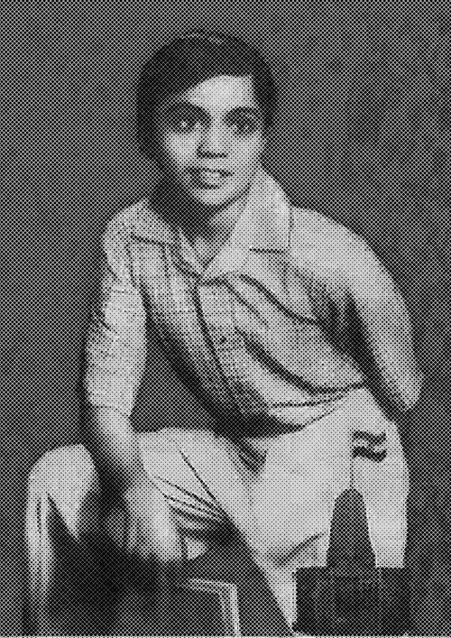
The Quit India Smarak, now located at the site of the incident, stands in memory of these five individuals. Their deaths remain one of the most widely remembered episodes of Nandurbar’s participation in the freedom movement.

Post-Independence
After India gained independence in 1947, the region that is now Nandurbar district remained part of West Khandesh, with administrative headquarters in Dhule. At the time, the area had not yet acquired a distinct district identity, though its boundaries and governance began to evolve gradually in the decades that followed.
In 1950, Akkalkuwa (now a taluka in Nandurbar) was created as a new subdivision within this district. Following the States Reorganisation Act of 1956, the region was incorporated into Bombay State, and later, with the formation of Maharashtra on 1 May 1960, it became part of that newly formed state.
The States Reorganisation Act of 1956 brought further change. With the reorganisation of linguistic states across India, this region was absorbed into Bombay State. A few years later, on 1 May 1960, the creation of Maharashtra State saw Nandurbar and the surrounding areas officially becoming part of the new Marathi-speaking state.
During this period, the redrawing of state boundaries deeply affected Nandurbar and led to the transfer of several border villages. With the formation of Gujarat State in 1960, administrative adjustments were noted to be made; 38 villages each from Nandurbar and Nawapur, 43 from Taloda, and 37 from Akkalkuwa were reassigned to Gujarat.
The long-standing demand for greater local representation and better administration led to the creation of Nandurbar district in July 1998. The new district was formed by separating six talukas: Nandurbar, Nawapur, Shahada, Taloda, Akkalkuwa, and Akrani, from Dhule. At its formation, the district comprised 933 villages. Following the 1991 Census, administrative revisions saw 17 villages added and 3 removed from official records.
Indigenous Communities and Cultural Identity
Nandurbar is notable for its predominantly tribal population, with Scheduled Tribe communities forming the demographic majority. The Bhil community is the largest among them, alongside other indigenous groups distributed across the six talukas. These communities have maintained distinctive languages, social customs, and religious beliefs, many of which are rooted in oral traditions and seasonal observances. Local festivals, community gatherings, and clan-based knowledge systems remain important aspects of daily life, contributing to the district’s enduring cultural identity.
What many might not know is that linguistically, Nandurbar is unique within the state. It is the only district in Maharashtra where Bhili (also known as Bhilodi) is the most commonly spoken first language, surpassing Marathi. According to the 2011 Census of India, the district recorded a population of 16,48,295, with 45.77% (nearly 7.5 lakh of them) identifying Bhili/Bhilodi as their mother tongue.
Political Representation and Electoral Significance
Since independence, the Nandurbar region has been represented as a distinct constituency in both the Maharashtra Legislative Assembly and the Lok Sabha. It has generally remained aligned with the Indian National Congress, particularly from the mid-20th century through the early decades of statehood. The constituency has been designated as reserved for Scheduled Tribe candidates, perhaps in line with the demographic composition of the district.
The district has occasionally drawn national attention during electoral campaigns and official events. Nandurbar is where Sonia Gandhi addressed one of the largest rallies she held after she had joined active politics and started campaigning for Congress in Maharashtra. A decade later, on 29 September 2010, Prime Minister Dr. Manmohan Singh and Congress president Sonia Gandhi chose Tembhli village in Nandurbar to launch the Aadhaar scheme, marking the formal rollout of the national identity card project by the Government of India.
Sources
Bhagwansingh Suravanshi. 1961. The Abhiras: Their History and Culture. Baroda: The Maharaja Sayajirao University of Baroda Press (Sadhana Press).
Durg Bharari. Akrani Mahal. Durg Bharari.https://durgbharari.in/akrani-mahal/
Durg Bharari. Nandurbar. Durg Bharari.https://durgbharari.in/nandurbar/
Government of Maharashtra. 1974. Maharashtra State Gazetteers: Dhulia District. Gazetteers Department.
Government of Maharashtra. “History.” District Nandurbar.https://nandurbar.gov.in/history/
James M Campbell. 1880. Gazetteer Of Bombay Presidency: Khandesh, Vol. 12. Government Central Press, Bombay.
Lokmat News18. 2022. Kedareshwar Temple Prakasha Nandurbar: Pratikashi of South India. Lokmat News18. Accessed March 17, 2025.https://lokmat.news18.com/religion/kedareshw…
Office of the Registrar General & Census Commissioner, India. 2011. Census of India 2011: Language Census. Government of India. https://censusindia.gov.in/nada/index.php/ca…
R.E. Enthoven. 1987. The Tribes and Castes of Bombay, Vol. 1. Cosmo Publications, New Delhi.
Saikumar Reddy et al. Overview of the Nandurbar District. Vikaspedia.https://en.vikaspedia.in/viewcontent/aspirat…
Wikipedia Contributors. Abhira Kingdom. Wikipedia.https://en.wikipedia.org/wiki/Abhira_kingdom
Last updated on 5 November 2025. Help us improve the information on this page by clicking on suggest edits or writing to us.