Contents
- Ajinkyatara Fort
- Bhambavali Flower Plateau
- Bhambavli Vajrai Waterfall
- Char Bhinti
- Chavneshwar Mountain
- Dholya Ganpati Mandir
- Jabareshwar Mandir
- Jalmandir Palace
- Kaas Dam
- Kaas Plateau
- Karad Caves
- Koyna Backwater, Bamnoli Village
- Krishna-Venna Sangam
- Vishveshwar Mandir
- Rameshwar Mandir
- Memorial of Maharani Yesubai
- Mahabaleshwar
- Mhaswad Village
- Panchgani
- Panchganga Mandir
- Pateshwar Mandir
- Phaltan Rajwada
- Shri Ram Mandir
- Pratapgad Fort
- Bhavani Mandir
- Preeti Sangam
- Rajpuri Caves
- Rajwadas of Satara
- Juna Rajwada
- Nava Rajwada
- Ramban Tirtha
- Santoshgad
- Shambhu Mahadev Mandir
- Shivaji Museum
- Tapola Lake
- Vasota Fort
- Sources
SATARA
Cultural Sites
Last updated on 22 July 2025. Help us improve the information on this page by clicking on suggest edits or writing to us.
Ajinkyatara Fort
Ajinkyatara Fort, located in Satara taluka, is a historic hill fort built at an altitude of around 3,300 ft. on Ajinkyatara Mountain in the Sahyadri range. It is known for its panoramic views of Satara city and is considered one of the important heritage sites of the region.
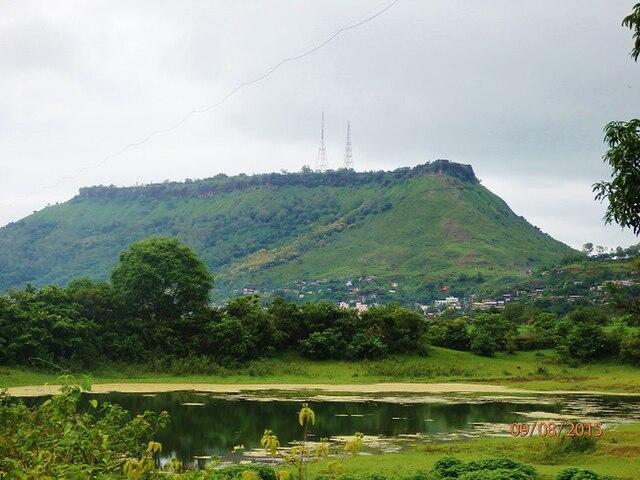
Also called the ‘Fort of the Sapta-Rishi,’ Ajinkyatara has thick walls, bastions, and two gates—one of which is reinforced with high buttresses. Inside the fort are water tanks and mandirs dedicated to Devi Mangalai, Bhagwan Shiv, and Hanuman.

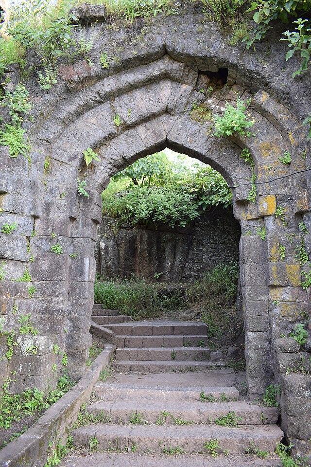
The fort is believed to have been built by Raja Bhoj of the Shilahara dynasty. Over time, it changed hands several times. Chhatrapati Shivaji Maharaj captured it from the Adil Shahi dynasty in 1673. It later came under Aurangzeb’s control from 1700 to 1706. In 1708, Chhatrapati Shahu Maharaj reclaimed the fort for the Marathas, who held it until the British took over in 1818. Ajinkyatara is also known for its role in Maratha history, including the imprisonment of Tarabai Bhosale, the regent queen and mother of Shivaji II.
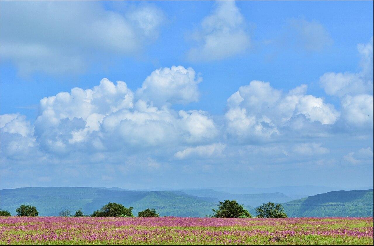
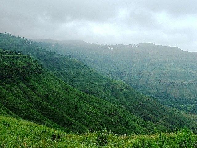
Bhambavali Flower Plateau
Bhambavali Flower Plateau, also known as Pushp Pathar, is a scenic hill plateau located about 30 km. from Satara city. According to Satara’s official website, the plateau is composed mainly of basalt rock with a thin layer of soil formed by erosion, the plateau is renowned for its rich biodiversity, housing over 150 species of flowers, shrubs, and grasses, including many rare and endangered varieties.

During the monsoon season, especially from August to early October, the plateau transforms into a vibrant ‘valley of flowers’, showcasing a stunning display of colors. This is the ideal time for visitors to experience its beauty. Bhambavali Flower Plateau has become a popular tourist destination, attracting nature lovers, hikers, and those interested in the region’s history and culture. It is also favored for birdwatching and wildlife photography, with residents such as Indian leopards, Sambar deer, and wild boars.
Culturally and historically significant, the plateau was once home to a thriving Jain community, evidenced by the numerous Jain mandirs and caves still present. Additionally, it is believed to be the site of a battle between the Marathas and the Mughals in the 17th century, further enriching its historical narrative.
Bhambavli Vajrai Waterfall
Bhambavli Vajrai Waterfall, located near Bhambavli village in Satara district, is the tallest waterfall in Maharashtra, with a height of approximately 853 ft. Located in the Sahyadri mountain range, Vajrai Waterfall is most impressive during the monsoon season (June to September) when the water flow is at its peak. Its impressive height, scenic beauty, and cultural significance make it a natural wonder that draws tourists from afar.
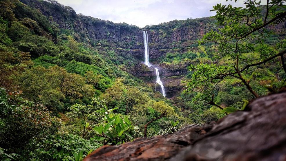
The waterfall also holds cultural significance, as it is linked to the legend of Bapuji Pendekar, a shepherd who gave his life to protect the forest. In his honor, the waterfall was named Vajrai, derived from the Sanskrit word vajra, meaning thunderbolt.
Bhambavali Vajrai Waterfall not only offers stunning views but also serves as a hub for adventure enthusiasts who can explore nearby hills and nature trails. Accessibility is convenient, as it is located near the village of Bhambavali, approximately 25 km from Satara city, making it easy for visitors to experience its beauty firsthand.
Char Bhinti
Char Bhinti is a Martyr Memorial located in Satara, near Ajinkyatara Fort. This monument holds historical significance and is a popular tourist destination. It was first viewed by Chhatrapati Pratap Sinha Maharaj in 1830, serving as a gathering point for the royal family's women to observe the Vijaya Dashami procession.
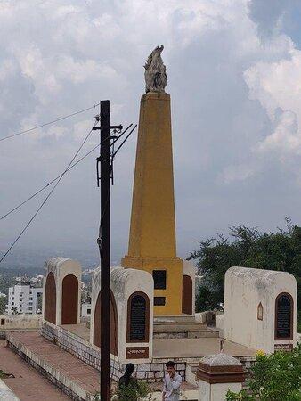
Originally known as the ‘Nazar Mahal’, the site later became a memorial for the martyrs of the 1857 War of Independence. The monument features walls on all four sides and a central pillar commemorating notable figures like Rani Lakshmibai, Tatya Tope, and Rango Bapuji Gupte. It was established to mark the centenary anniversary of the first fight for independence against the British and was refurbished in 2001.
Chavneshwar Mountain
Chavaneshwar Mountain, located on the border of Koregaon and Wai talukas in Satara district, is a site of historical and cultural importance. Its foundation is associated with the great ascetic Chyavanrishi, believed to have performed penance here before attaining Samadhi in Karnataka. Known as the only mountain in Koregaon taluka, it is about 1,300 meters above sea level and rich in medicinal plants, many of which are used in Ayurveda. It is also believed that Chyavanrishi created the Ayurvedic formulation Chyavanprash at this very site. The mountain’s freshwater spring is still revered today, with believers collecting the water as a remedy for illness.
Chavaneshwar played an important role during the time of Chhatrapati Shivaji Maharaj, with the Mavalas (local militia) of this region contributing to the establishment of Swarajya. Villagers also supported underground freedom fighters during India’s independence struggle. Even today, locals recount these stories with pride.
The mountain is home to three main mandirs—dedicated to Shri Chavaneshwar, Mahadev, and Janubai. A fourth, Shri Kedareshwar Mandir, located about a kilometer into the forest, is believed to date back to the Pandava period. People visit throughout the year, with large gatherings on Sundays, Mondays, Amavasyas, and Pournimas.
The annual yatra, held on the fourth weekend of Ashwin, draws people from surrounding villages, especially for the visit of respected Sasanakathas (ceremonial procession groups). The yatra is marked by devotion, with no animal sacrifices or entertainment programs allowed.
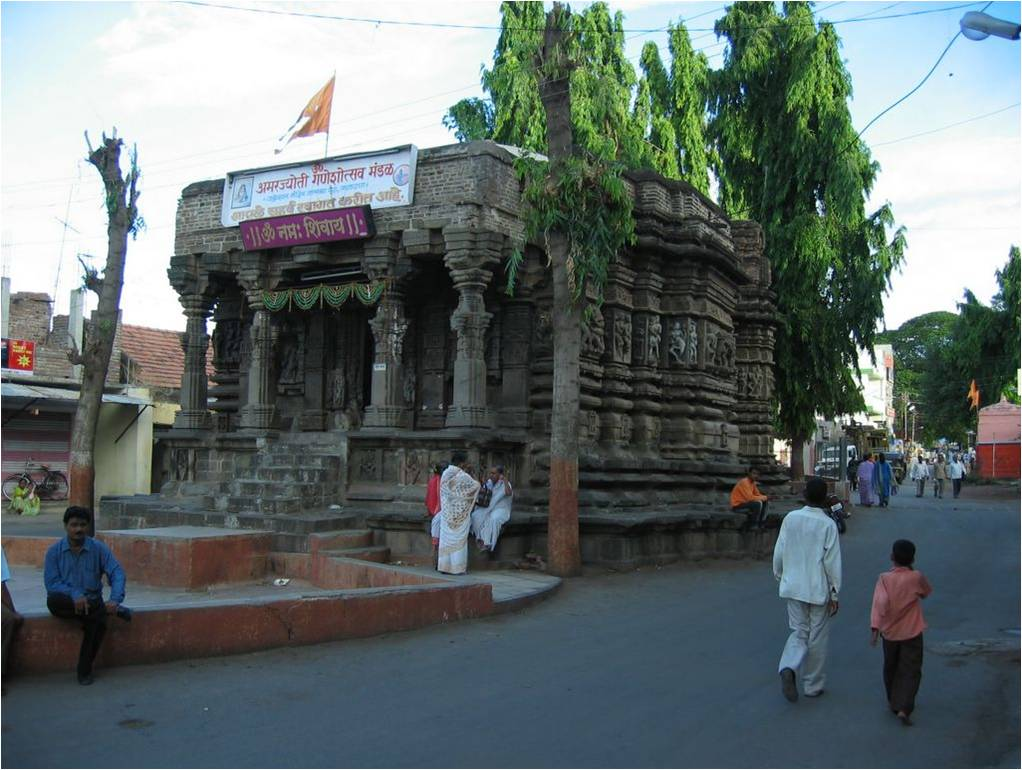
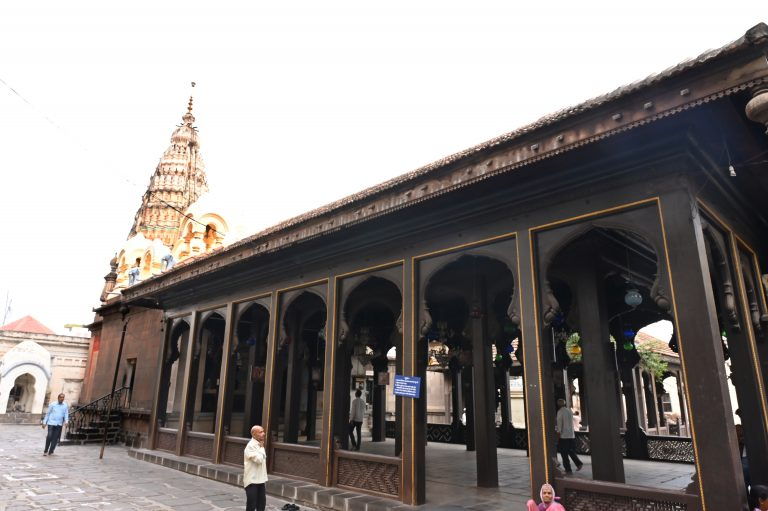
Dholya Ganpati Mandir
Dholya Ganpati Mandir is one of the prominent mandirs in Wai, a town located 36 km from Satara city and often referred to as "Dakshin Kashi" for its more than 100 mandirs. The Mandir houses the largest Ganpati murti in Maharashtra, a massive figure carved from a single black stone, standing 10 ft. tall and 8 ft. wide. The word Dholya means ‘fat’ in Marathi, making ‘Dholya Ganpati’ literally translate to ‘the fat Ganpati.’ According to locals, the height of the Ganpati is believed to increase slightly every year.
Jabareshwar Mandir
Jabareshwar Mandir is a rock-cut structure located in Phaltan town in Satara district. Believed to have been carved from a single rock around 1237 CE, the Mandir is an example of Hemadpanthi architecture and is thought to have been originally dedicated to the 23rd Jain Tirthankar. Over the centuries, the structure has witnessed several transitions, with a Shivling now installed inside its garbhagriha (sanctum).
Though the Mandir is a protected monument under the Ancient Monuments and Archaeological Sites and Remains Act, 1958, its history remains largely undocumented. The Mandir’s external carvings depict human figures in expressive poses, while the interiors—cool and shaded—feature colourful walls and images of various deities. A Nandi murti faces the Shivling, and the Mandir is unusual in that the Shivling is placed east to west, with the entrance facing north, differing from most other Shiv mandirs in Maharashtra.
Located amidst the busy market lanes of Phaltan, the Mandir is surrounded by shops and rarely visited, except by occasional travelers. Though largely unknown to tourists today, it remains a significant but overlooked example of medieval rock-cut architecture in the region.
Jalmandir Palace
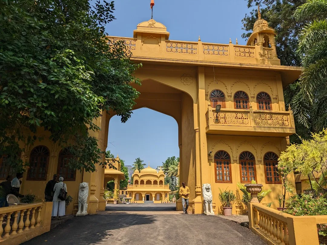
Jalmandir Palace adds a distinctive royal presence to Satara’s landscape and stands as part of the legacy of Chhatrapati Shivaji Maharaj. Today, it serves as the private residence of Chhatrapati Udayanraje Bhosale, the present heir of the Maratha royal family in Satara. The palace complex includes a beautifully maintained garden and a Mandir dedicated to Jagdamba Mata. While the premises are not open to the general public, access is occasionally granted during special events or celebrations.
Kaas Dam
Built in 1875, the Kaas Dam, located 30 km west of Satara, is one of the oldest dams in the state, located within the Kaas Plateau Reserved Forest, a UNESCO World Natural Heritage Site. The Kaas Dam serves as a vital water source for the region, supplying drinking water to Satara city and nearby villages, supporting irrigation, and generating hydroelectric power for the district.
It is particularly popular among tourists during the monsoon season when the dam is at its fullest, surrounded by lush green hills. Visitors often enjoy picnics and scenic views, and the area features several hiking trails that offer stunning vistas of the dam and its natural surroundings. As a significant landmark in Satara, the Kaas Dam not only plays a crucial role in water management and energy production but also serves as a beautiful recreational spot in the Western Ghats.
Kaas Plateau
The Kaas Plateau Reserved Forest, also known as the Kaas Pathar, is a plateau situated 25 km west of Satara city. According to Suresh Kumar Shah and Bulganin Mitra (2015), it falls under the Sahyadri Sub-Cluster of the Western Ghats, and it became a part of a UNESCO World Natural Heritage Site in 2012.
It is a biodiversity hotspot known for various types of seasonal flowers blooming and numerous species of endemic butterflies that bloom annually in August and September. The plateau experiences a natural cycle of extreme conditions, with wet water-logged cool monsoons, very dry hot summer (45 °C), and dry winter (5 °C). The soil is acidic with only a thin layer on top of laterite rock underneath. Extreme seasonality influences the ecology of the site.
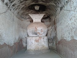
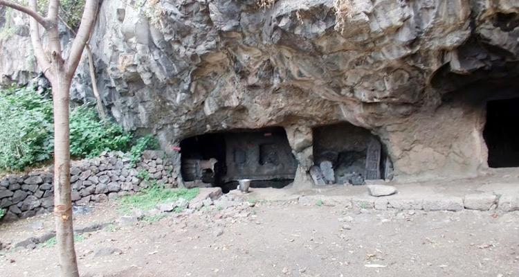
Karad Caves
The Karad Caves are a group of ancient Buddhist rock-cut caves located about 5 km southwest of Karad, near the village of Jakhinwadi in Satara district. Overlooking the Koyna River, these caves are carved into the Agashiv hill and its surrounding spurs. Together, they form one of the earliest and largest groups of Buddhist caves in Maharashtra, with a total of 66 excavations spread across three main clusters—Agashiv Caves, Bhairav Caves, and Dongrai Caves.
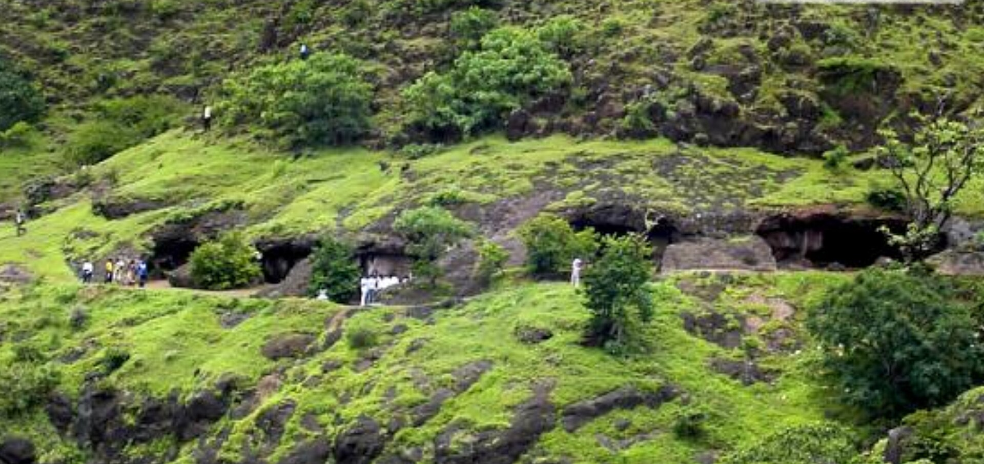
Dating back to the 1st century BCE, the caves are noted for their simplicity, with plain viharas (monastic dwellings) and small chaityas (prayer halls). They are among the earliest examples of rock-cut Buddhist architecture in the region, roughly contemporary with sites like Karle, Bhaja, and Nasik. Many caves contain stone benches carved for use as beds. Some caves retain carvings of Buddhist symbols such as wheels (chakras) and lions (simhas), especially seen in Cave 5 and Cave 30. A significant inscription in the caves records a donation by Sanghamitra, the son of Gopala, highlighting the site's early religious patronage.
One of the caves is also traditionally associated with Chokhamela, the 14th-century Varkari sant, who is believed to have stayed there for several years.
Though mostly plain, the caves offer glimpses of early Buddhist architectural styles. Features like square window openings, stone relic shrines (daghobas), and faint traces of early sculptures connect them to the early phases of Buddhist cave development in western India. The soft amygdaloidal rock in which the caves are carved has suffered significant weathering, with only a few inscriptions and reliefs remaining legible today.
The Karad Caves hold archaeological importance not only for their early date but also for their role in tracing the spread of Buddhism in Maharashtra. Their association with both ancient Buddhist traditions and later Bhakti figures like Chokhamela makes them a unique site linking different spiritual movements in the region.
Koyna Backwater, Bamnoli Village
Bamnoli, located on the banks of the Koyna River in Jaoli taluka, is known for its scenic backwater reservoir surrounded by hills and dense forests. This picturesque landscape makes it a popular destination for boating, with bamboo rafts and motorboats offering views of the surrounding hills and greenery.
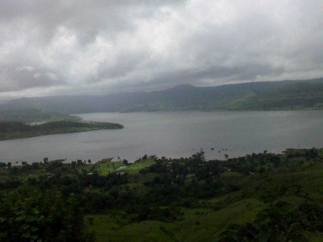
The Koyna backwater is also a thriving spot for fishing, home to species like carp, catfish, and mahseer. The area’s rich biodiversity includes numerous birds, butterflies, and small mammals. Bamnoli also serves as the gateway to the Koyna Wildlife Sanctuary, offering opportunities for wildlife spotting, nature walks, and jungle safaris.
In addition to natural beauty, Bamnoli is the starting point for treks to sites like Vasota Fort and Nageshwar Cave. The village is also home to yatra sites such as the Nageshwar Mandir and Vyaghreshwar Mandir, which draw bhakts from the region.
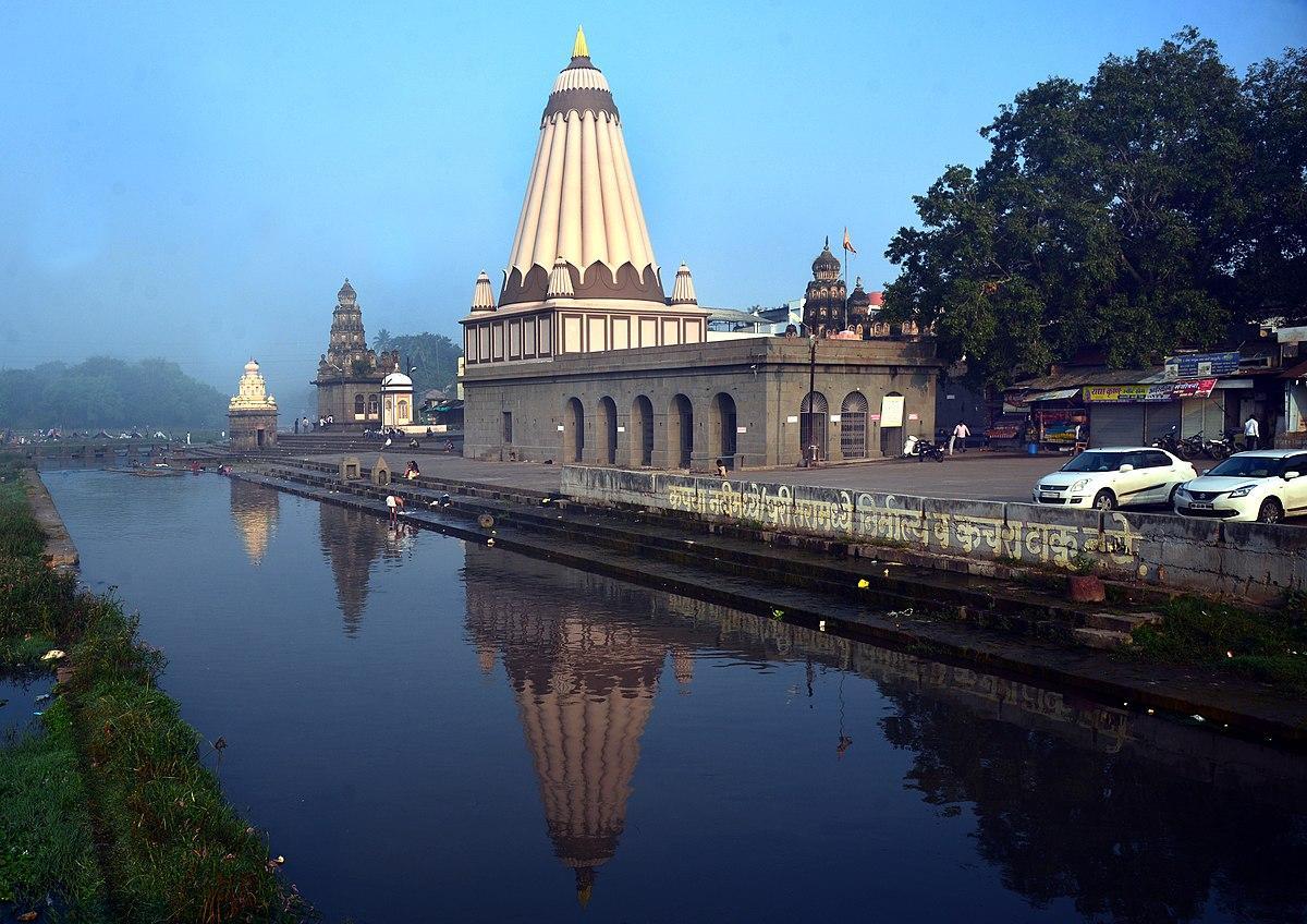
Krishna-Venna Sangam
Krishna-Venna Sangam, also known as Sangam Mahuli, is located about 5 km east of Satara city, at the confluence of the Krishna and Venna rivers. This site is home to a group of 18th and 19th-century mandirs built in typical Maratha architectural style, characterized by basalt stone construction, carved domes, and arcaded passageways. The meeting of the two rivers, combined with the historical and religious importance of the site, makes it an important yatra destination in the region.
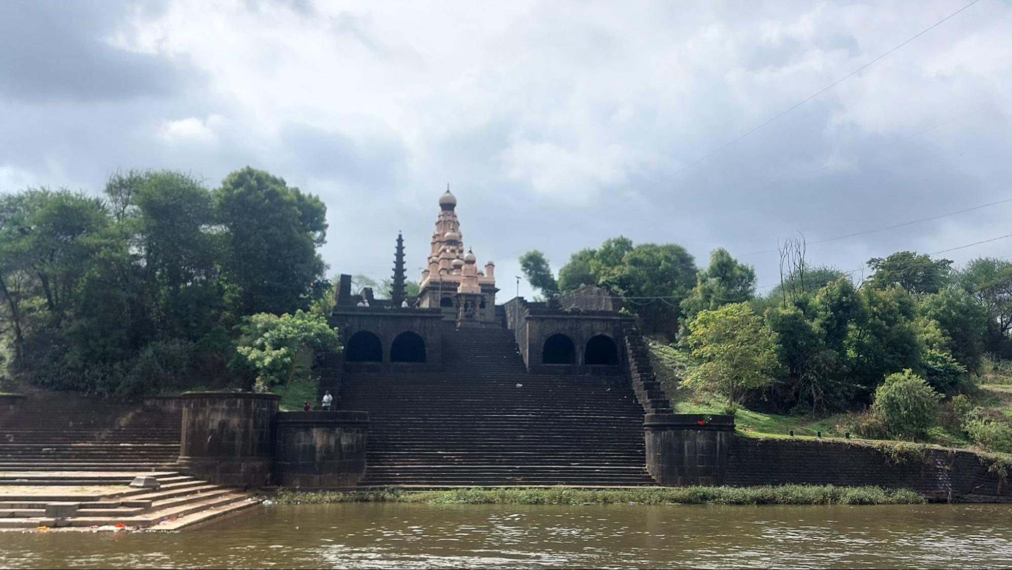
The establishment of the mandirs at Sangam Mahuli is closely associated with the patronage of Chhatrapati Shahu Maharaj, who granted the land to his minister, Shripatrao Pant Pratinidhi. The mandirs were built over time by Shripatrao and other local Brahmins, making this area both a religious centre and a symbol of Maratha-era patronage. Sangam Mahuli is also remembered for its connection to historical events, such as the meeting between Bajirao II and Sir John Malcolm before the Third Anglo-Maratha War, and is known as the birthplace of Ramshastri Prabhune, an important figure in Maratha history.
Vishveshwar Mandir

The most prominent Mandir at Sangam Mahuli is the Vishveshwar Mandir, dedicated to Bhagwan Shiv in the form of Vishveshwar. Built in 1735 CE by Shripatrao Pant Pratinidhi on land donated by Chhatrapati Shahu Maharaj, this stone-built structure exemplifies the Hemadpanthi architectural style seen across the region. The layout consists of a sabhamandap (assembly hall), antarala (vestibule), and garbhagriha, with murtis of Ganesh and Parvati placed in niches along the passageways. The shikhar is crowned with fluted domes and decorated with stucco figures, with miniature replicas clustered around the central tower. In front of the Mandir stands a striking 60 ft. deepastambha, carved from a single stone with niches for oil lamps. A separate small Nandi mandap with an intricately carved dome completes the composition.
An arcaded passageway runs along two sides of the Mandir, with hidden stairways leading to its upper levels. From here, visitors can get elevated views of the complex and the surrounding confluence of the Krishna and Venna rivers.
Rameshwar Mandir
Another significant Mandir at the Krishna-Venna sangam is the Rameshwar Mandir, situated by the Krishna river, in the village of Kshetra Mahuli. Also dedicated to Bhagwan Shiv, it is smaller than the Vishveshwar Mandir but holds local significance. Built in the Nagara style with brick and lime, its shikhar rises over a garbhagriha housing a Shivling, surrounded by the waters of the Krishna during certain seasons. Like its counterpart across the river, it has a sabhamandap with murtis of Ganesha and Parvati, a Nandi mandap, and a stone deepastambha.
Memorial of Maharani Yesubai
Sangam Mahuli is not only significant for its religious importance and architectural heritage but also for its association with one of the most powerful women of the Maratha Empire—Maharani Yesubai. The wife of Chhatrapati Sambhaji Maharaj and mother of Chhatrapati Shahu Maharaj, Yesubai was imprisoned by the Mughal emperor Aurangzeb for 29 years. After her release, she is believed to have arrived in Satara around 1729 CE, where she spent the remainder of her life.
For many years, the exact location of Maharani Yesubai’s memorial remained unknown. However, recent research conducted by Satara-based historians and organisations such as the Jidnyasa Itihas Sanshodhan ani Sanvardhan Sanstha has led to the identification of her tomb at Mahuli, near the Krishna-Venna Sangam. The site features a stone Vrindavan and dome, marking the final resting place of this important historical figure.
In recognition of its significance, the Government of Maharashtra has recently declared the site as a state-protected monument. Conservation efforts are expected to begin in the coming years under the supervision of the state archaeology department. Today, this memorial stands as a testament to Maharani Yesubai’s resilience, as well as her role in shaping the history of Satara and the Maratha Empire.
Mahabaleshwar
Mahabaleshwar, located about 60 km from Satara city, boasts a rich history that dates back to the 12th century. Originally a small village, it was ruled by the More clan, vassals of the Adilshahi Sultanate of Bijapur. In 1656, Chhatrapati Shivaji Maharaj defeated Chandra Rao More, the ruler of the Valley of Javali, and seized the area. Around the same time, Shivaji built Pratapgad Fort near Mahabaleshwar. The Marathas later constructed several palaces and mandirs here, making it a favored retreat for royalty and their guests.
Mahabaleshwar is also the source of the river Krishna, and the Panchganga Mandir marks the origin of the river. The surrounding Sahyadri hills form a stunning backdrop to the landscape. In the 19th century, the British discovered Mahabaleshwar’s scenic beauty and pleasant climate, leading to the development of hotels and resorts for colonial officers and their families. Many colonial-era buildings from this period still stand today.
The hill station is famous for its breathtaking viewpoints, including Arthur’s Seat, Kate’s Point, Wilson Point (Sunrise Point), and Elephant’s Head Point. Additionally, Mahabaleshwar is well-known for its strawberry cultivation, thriving due to the region’s cool climate and fertile soil. Visitors can enjoy strawberry picking and indulge in fresh strawberries, jams, and desserts. The annual Strawberry Festival celebrates this harvest, attracting many tourists.
Mhaswad Village
Mhaswad, located in Man taluka of Satara district, is known for its rich cultural heritage, blending Maharashtrian traditions and customs. The town plays a significant role in the region’s agricultural economy, benefiting from Satara’s fertile land and farming activities.
A notable historical landmark here is Mhaswad Fort, also known as Mhaswadicha Killa. Built during the Maratha Empire, the fort once served as a strategic stronghold. Though in ruins today, it stands as a testament to the area’s historical importance. Another prominent site is the Siddhanath Mandir, renowned for its exquisite stone craftsmanship. Mhaswad is also home to several other mandirs, including the Vitthal Mandir and Rameshwar Mandir, which reflect the artistic skills of ancient artisans and continue to serve as important places of worship.
Panchgani
Panchgani is a picturesque hill station located about 50 km from Satara city, in Mahabaleshwar taluka. Its name means ‘five plateaus’ (Panch means five in Marathi), referring to the five flat hills that shape its landscape. The town’s history dates back to the colonial era, when it served as a summer retreat for British officials from Pune and Mumbai. Drawn by its mild climate and scenic beauty, they established schools and residential colonies here, many of which still stand today, adding to the town’s historical charm.
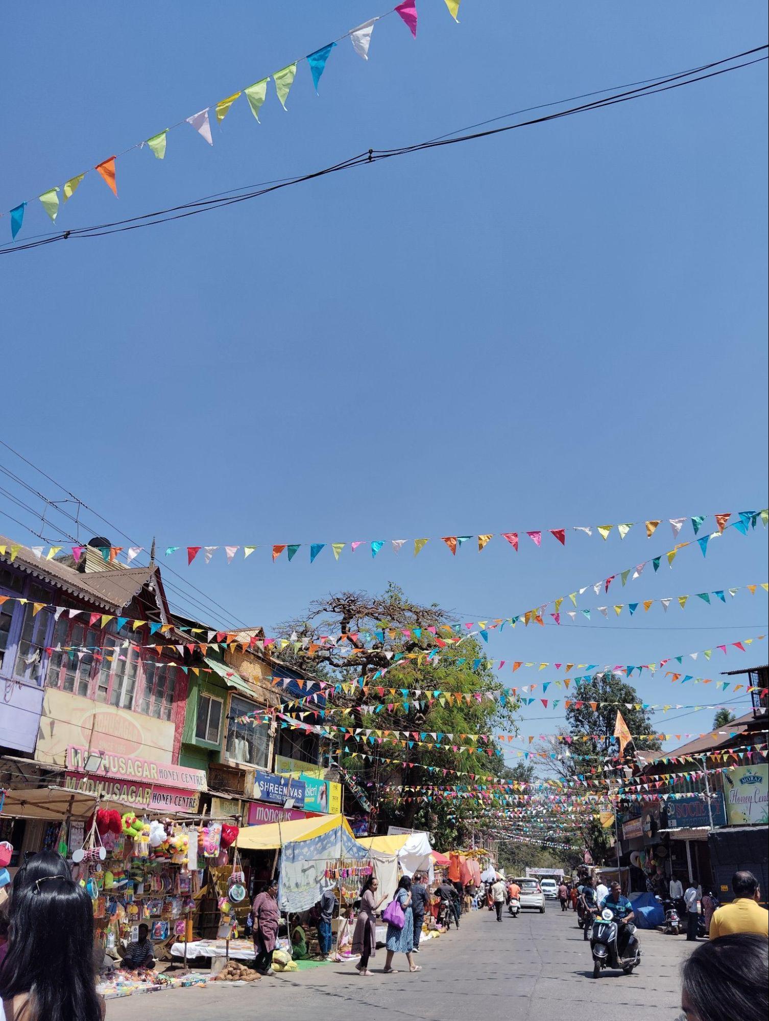
Situated at an elevation of about 1,334 m, Panchgani enjoys pleasant weather throughout the year. Popular viewpoints like Table Land, Asia’s second-largest mountain plateau, attract visitors seeking panoramic views and a cool escape in summer. The region’s fertile soil also supports thriving strawberry plantations, making it a favourite destination for strawberry picking.
A key historical site in Panchgani is St. Peter’s Church, an Anglican church built in the late 1800s that showcases Gothic architecture, reflecting the town’s colonial heritage. Panchgani is also known for its contribution to education, with institutions like St. Peter’s School, established in 1904, shaping the town’s educational landscape.
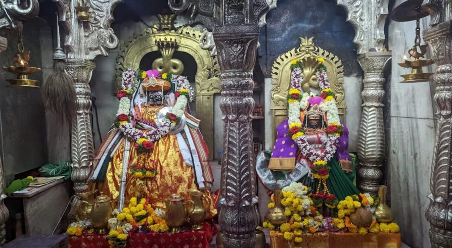
Panchganga Mandir
The Panchganga Mandir in Old Mahabaleshwar is located at the source of seven rivers: Krishna, Koyna, Gayatri, Savitri, Venna, Saraswati, and Bhagirathi. Of these, five rivers flow continuously, while the Saraswati is believed to emerge once every 60 years, and the Bhagirathi every 12 years. This confluence gives the Mandir its name—Panch meaning five, and Ganga referring to a holy river.
The Krishna River, originating here, is the third-longest river in India, flowing for about 1,400 km and draining nearly 8% of the country’s land. The Koyna and Venna rivers join the Krishna as tributaries, flowing eastward, while the Gayatri and Savitri rivers flow underground in parts and eventually meet rivers in the Konkan belt.
In the centre of the Mandir are two tanks or kundas. The waters of the rivers emerge from the mouth of a carved stone cow (gomukh) into the first kunda, which then overflows into the second. While the first kunda is restricted, the second is open for visitors to dip their feet.
The current structure of the Mandir was built in the 13th century by Raja Singhandeo of the Yadava dynasty. Chhatrapati Shivaji later modified the structure in the 17th century, with further additions, such as a protective roof, made over time.
Close to the Mandir, traces of an older settlement in Old Mahabaleshwar can still be seen. Ruins of ancient gateways and walls hint at an earlier fortified site, although much of it has now been obscured by surrounding shops and stalls.
Pateshwar Mandir
Pateshwar Mandir is located about 10 km east of Satara city. This significant religious site is known for its collection of over 1,000 Shivlings and numerous murtis of various Devis and Devtas. The complex also includes a math (monastic establishment) associated with the Gosavi community and a cave shrine dedicated to Margal Mhasa.
At the centre of the complex is the main Mandir, featuring the Linga of Pateshwar. Around it stand notable Devtas: Ganesh and Darasmaruti facing south, Batashankar and Sheshshayi Vishnu facing north, with Ashtabhuja Devi and Bhairav positioned on either side. Many of the mandirs here were built during the reign of Chhatrapati Shahu by Parashuram Narayan Angal, renowned moneylender during that time, reflecting the site’s deep historical and architectural legacy.
The adjacent Margal Mhasa cave is spacious and contains several smaller caves filled with lingas. To the east is the Balibhadra or Agni shrine, which features a distinctive murti of a figure with a man’s head, a bull’s body, and four horns—an unusual fusion of human and animal forms. Nearby are several other murtis of Devis and Devtas, along with a recently constructed devasthan dedicated to Satwai Devi, adding to the diversity of this rich spiritual site.
Phaltan Rajwada
Phaltan Rajwada is located in Phaltan, around 60 km from Satara. Traditional Maharashtrian wadas, or mansions, represent a lifestyle long gone, and among them, royal palaces or rajwadas are even rarer. While many such structures across Maharashtra have disappeared or lie in ruins, Phaltan Rajwada, formally known as Madhoji Manmohan Rajwada, after the one who built it, remains a rare example that has survived.
From the 13th century CE to 1947, Phaltan was the seat of the Naik Nimbalkar dynasty, a family that played an important role in the region’s history for over 700 years. The dynasty traces its origins to an adventurer named Nimbra, a member of the Parmar Rajput clan from Malwa in Central India. Around 1270 CE, Nimbra arrived in the Deccan and established a principality at the foot of the Bhambhumahadev range, an offshoot of the Sahyadris. His descendants later settled at Nimblak, a village near Phaltan, giving the family its surname, ‘Nimbalkar.’
By 1327 CE, Nimbra’s grandson Nimbraj II had received a jagir (land grant) and the title ‘Naik’ from Sultan Muhammad Bin Tughlaq in recognition of his family’s service in battle. Over the centuries, the Naik Nimbalkars developed close ties with the Marathas, especially after the marriage of Saibai Nimbalkar to Shivaji Bhosale in 1640 CE. Phaltan remained a feudatory of the Chhatrapatis of Satara until 1849, when Satara was annexed by the British, making Phaltan a princely state under the Crown. Major Shrimat Malojirao Naik Nimbalkar was the last ruling Raja of Phaltan before its accession to India in 1947. The royal family remained politically influential in the region, and this continuity helped preserve Phaltan Rajwada as a seat of local authority and cultural life.
Construction of the Phaltan Rajwada began in 1861 and was completed in two phases by 1911. It replaced an earlier wada of the family on the same site. The palace, named after Madhoji Manmohan Naik Nimbalkar, blends Jain, Hindu, and Western styles, reflecting changes in architecture during that period. Its Indo-Saracenic design, with domes, circular pillars, and Gothic features, marks a shift from traditional designs to modern forms of the late 19th and early 20th centuries.
The main building is a two-storey structure, with courtyards on the ground floor, halls on the first floor, and bedrooms on the second floor. Prominent parts of the residential section include the Darbar Hall, Surucha Hall, Hirva Hall, Badami Hall, Saatkhani Laxmi Terrace, and Gulabi Hall. The walls feature paintings of Naik Nimbalkar rulers, including depictions of Maharani Saibai. The woodwork of the Rajwada stands out for its fine carvings of parrots, peacocks, and lions, and its halls are decorated with glass chandeliers. The palace also houses objects from the family’s hunting expeditions.
One of the most unusual events held here was the celebration of King George V’s coronation in 1911. Along with ceremonies in Delhi and London, Phaltan also held a grand procession and durbar. A portrait of the British monarch was paraded through the town on an elephant, followed by a durbar held in the Shri Ram Mandir inside the Rajwada, where the portrait was ceremonially blessed.
Shri Ram Mandir
An important feature of the Rajwada is the Shri Ram Mandir, located within its complex. The Mandir is over 225 years old and built in the Hemadpanthi style. It has an east-facing entrance, surrounded by a tall stone wall, and features three deepmala (lamp towers) at its front. The garbhagriha contains beautiful murtis of Ram, Sita, and Laxman. Adjacent to the Shri Ram Mandir are smaller mandirs dedicated to Radhakrishna, Ekamukhi Datta, and Garuda. Over generations, this Mandir has been a key religious site for the local community, with its festivals drawing people from the town and surrounding areas.
The chowk surrounding the Rajwada remains an active space shaped by these religious and historical layers. Today, the Phaltan Rajwada is managed by the Naik Nimbalkar Devasthan trust, which oversees its religious and charitable functions.
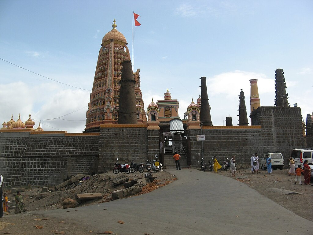
Pratapgad Fort
Pratapgad Fort, located near Mahabaleshwar in Satara district, stands at an elevation of 3,454 ft. Built to protect the Par Pass, it is about 21 km from Mahabaleshwar, accessed by a winding mountain road. The fort played an important role in defending the surrounding region, including the Wai area.

From a distance, Pratapgad appears like a rounded hill, with the walls of the lower fort resembling a crown. Chhatrapati Shivaji Maharaj later authorised further fortifications, which were carried out by Moropant Trimbak Pingale, his chief minister. The fort is divided into two parts: the upper fort, located at the summit, and the lower fort, which has extensive outer defenses. The roughly square layout of the upper fort, with walls stretching around 590 feet on each side, offers sweeping views of Raigad and the coastal Konkan region.
Construction of Pratapgad was completed in 1656, with the primary aim of controlling the important trade and military route of the Par Pass and safeguarding the banks of the Koyna and Nira rivers. The fort is remembered for the famous encounter between Shivaji Maharaj and Afzal Khan. After Shivaji’s victory in that battle, the influence of the Maratha Empire expanded across the region. In 1818, after the Third Anglo-Maratha War, the fort was surrendered to British forces. A 17-foot-tall bronze statue of Shivaji Maharaj was installed here in 1957 by Prime Minister Jawaharlal Nehru in honour of his legacy.
Bhavani Mandir
Bhavani Mandir, located within Pratapgad Fort, was built by Shivaji Maharaj in the 17th century and holds deep historical and cultural significance. Dedicated to Mata Bhavani, a form of Durga or Parvati, the Mandir reflects Shivaji’s deep devotion to the Devi, whom he worshipped as his protector and guide.
The Bhavani Mandir features exquisite architecture that reflects the Maratha style. It has a simple yet elegant design with stone carvings, ornate pillars, and a distinct entrance gate. The Mandir’s architecture showcases the craftsmanship and architectural prowess of the Marathas during that period. The Mandir is considered a sacred yatra site for the bhakts of Mata Bhavani and followers of Shivaji. It attracts yatri and history enthusiasts who seek blessings, pay homage, and learn about the historical significance associated with the Mandir and the fort.
Preeti Sangam
Preeti Sangam, located in Karad about 60 km from Satara, is a unique site where the Krishna and Koyna rivers meet. This confluence, known for its scenic beauty, forms a distinct ‘T’ shape—considered the only known head-on confluence of two rivers in the world.
Both rivers originate in Mahabaleshwar, roughly 100 km from Karad, and despite flowing along different routes, they cover almost the same distance before merging here. The name Preeti Sangam, meaning ‘Confluence of Love,’ symbolizes unity and harmony. Surrounded by peaceful landscapes, Preeti Sangam is a popular spot for visitors and locals alike, offering a blend of natural beauty and cultural significance that reflects the diverse heritage of Karad.
Rajpuri Caves
Rajpuri Caves, located in Shindola, in Wai taluka, are a significant religious site known for their spiritual associations and scenic surroundings. These caves are believed to have sheltered the Pandavas during their exile and are also linked to Kartikeya, the son of Mata Parvati and Bhagwan Shiv, who are said to have performed sacred rituals here.
The site features four caves surrounded by serene water tanks, believed by bhakts to contain water from the Ganga with healing properties. A key feature of the complex is the Skanda Mandir, constructed using sand taken from the caves themselves.
Rajpuri Caves also host the annual Thaipooyam Festival, celebrated in January or February, drawing visitors from across the region.
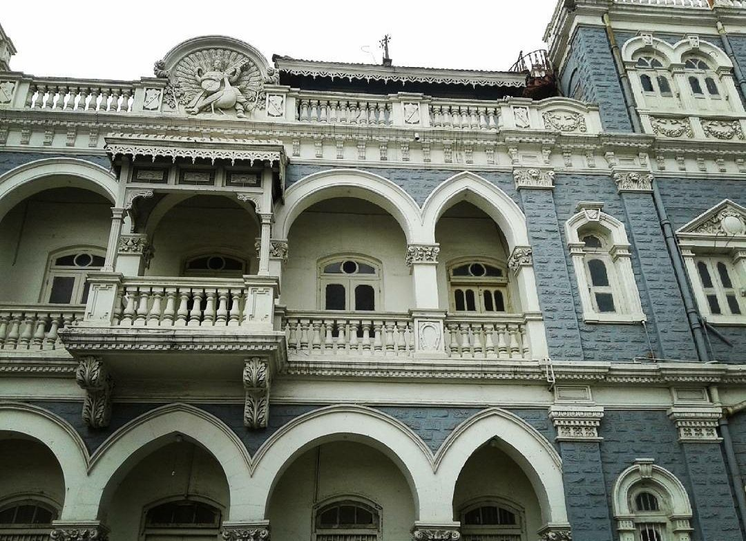
Rajwadas of Satara
The two rajwadas located in Shukrawar Peth, Satara, known as the Old Palace (Juna Rajwada) and the New Palace (Nava Rajwada), are important landmarks that reflect the city’s Maratha heritage. These structures stand as reminders of Satara’s role as a center of Maratha power, administration, and cultural life.
Juna Rajwada
The Juna Rajwada, or Old Palace, was built in 1824 by Raja Pratapsinh of Satara. It represents traditional Maratha architecture, with features like large terraces, balconies, and detailed stonework. Rising 50 ft. above the ground, the rajwada could be seen from over a mile away to the east. A large cistern was built into the right wing for the use of its residents, reflecting the thoughtful planning that went into royal residences of the period.
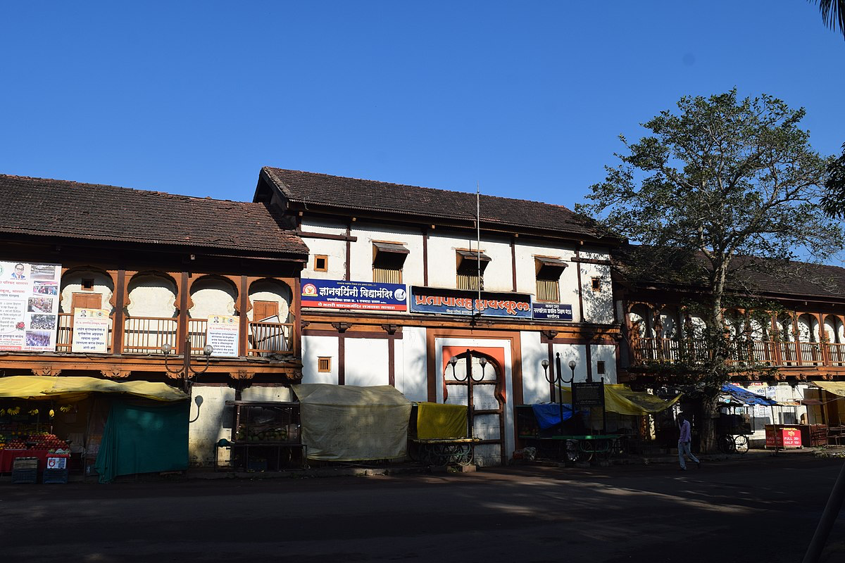
This rajwada once served as the seat of local administration and was central to important events in Satara’s history. During the famine of 1876–77, it was used as a relief center, providing shelter and aid to the people of the region. In later years, it was repurposed to house the Government High School, now known as Pratapsinh High School, as well as primary schools, municipal offices, and other government departments.
Despite changes in its use over time, the Juna Rajwada retains its historical significance, offering a window into the Maratha era’s architecture and royal life.
Nava Rajwada
The Nava Rajwada, or New Palace, was built between 1838 and 1844 by order of Raja Shahaji. It was designed by a British engineer named Mr. Smith, who also oversaw the construction of several bridges in Satara during the same period. The New Rajwada reflects the changing influences of the 19th century, blending traditional Maratha elements with newer architectural styles.
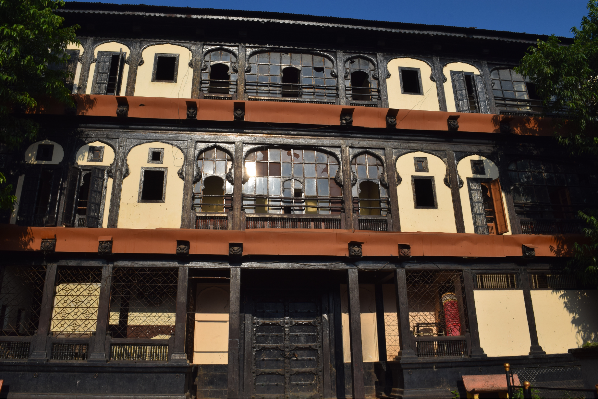
The structure has a distinctive façade adorned with traditional motifs, though many have eroded over time. Inside, a large courtyard is surrounded by a broad colonnade, with a grand hall supported by 64 teak pillars on its western side. These pillars were once richly decorated with brocade and gold embroidery during royal functions. A separate audience hall at the upper end of the courtyard was dedicated to Devi Bhavani, the kuldevi of the Marathas. The rajwada also once housed Bhavani, the famous sword of Chhatrapati Shivaji Maharaj, kept in a richly carved room near the colonnade.
After coming under British control in 1876, the rajwada served various administrative functions. It housed the district and sessions courts and other offices such as the treasury, Satara City Survey Office, and the Divisional Forest Office. Although it is now undergoing changes in function, the rajwada remains an important part of Satara’s architectural and historical legacy.
Together, these two rajwadas preserve the layered history of Satara—its role in the Maratha Empire, the adaptations during British rule, and the continued pride of local residents in their city’s past.
Ramban Tirtha
Located in Patan taluka, Ramban Tirtha is a site of both natural beauty and legendary significance. Just 2.5 to 3 km from Ozerde Falls, this spot is nestled in the dense forests of Navaja and is closely associated with episodes from the Ramayan.
According to local legends, Bhagwan Ram, Sita, and Lakshman passed through this forest during their 14-year exile. As they journeyed through the thick wilderness, Sita, overcome by thirst, requested water from Shri Ram. Finding no water nearby, Ram struck a large stone with his arrow (ban), causing a spring of fresh water to emerge. Sita and Lakshman quenched their thirst at this spot before continuing on their journey. This site has since been revered as Ramban Tirtha, meaning the holy spring created by Ram’s arrow.
Even today, visitors can see this remarkable stone in the forest. The stone, shaped like an arrowhead, continuously provides cool water throughout the year. Uniquely, the water flows from the stone without any signs of seepage around its base, and the stone itself stands about 6 ft. above the ground.
The site is especially popular during Ram Navami, when villagers gather to celebrate the occasion. Visitors and Ram bhakts drink from this spring, considering the water sacred.
Santoshgad
Santoshgad, also known as Tathawade after the nearest village, is a hill fort in Phaltan taluka of Satara district, located about 19 km southwest of Phaltan. The fort stands on the Mhasoba mountain range, part of the Sahyadris, alongside other forts like Warugad, Mahimangad, and Vardhangad. This range forms one of the three divisions of the Sahyadris branching out from Pratapgad. Although the region receives relatively low rainfall, it has flourished in recent years due to sugarcane cultivation.
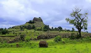
The fort is divided into three sections: the outer defensive ramparts, a central towered section, and the uppermost bastion. From the ramparts, the distant Tathawada Ghat can be seen to the west, while Sitabai Mountain and Warugad are visible along the southeastern range. Remarkably, unlike many other forts where fortifications have decayed, Santoshgad’s ramparts and bastions remain largely intact.
There are several architectural features on the fort itself, including remnants of the old gateway with its guard towers still standing in good condition. Inside the fort are the remains of residential structures, granaries with ruined roofs, and a notable stepped water tank carved into the rock. A Hanuman tank lies near the entrance, and a stone-cut staircase leads down to a concealed water reservoir—an important resource for nearby villagers even today.
The route to the fort passes a monastery with a cave and cold water reservoir, where a murti of Valmiki is housed. Though the gateway’s arch has mostly disappeared, its former scale can still be imagined from the surviving fragments. Along the way is a smaller Mandir, after which a path leads directly to the main fort entrance.
Santoshgad was among the forts repaired by Chhatrapati Shivaji Maharaj to strengthen defenses against attacks from the Bijapur Sultanate. It is believed that the Thane Raja of Warugad was defeated during the period around Shivaji’s Agra campaign. After the decline of Maratha power, the British dismantled several of the fort’s structures, including gates and pathways, but much of its defensive architecture still stands as testimony to its former strength.
Tathawade village at the foot of the fort is home to the Shri Balsiddhnath Mandir, a fine example of Peshwa-era architecture. Constructed in 1761 by Visajipant Samanath Deshpande, an official in the Peshwa administration, the Mandir connects the fort’s history with the cultural life of the region. The Mandir’s annual yatra festival continues to this day, preserving traditions that date back to the 18th century.
Santoshgad stands today as a reminder of the Maratha Empire’s military efforts in this region, offering both historical interest and panoramic views of the surrounding Deccan plateau.
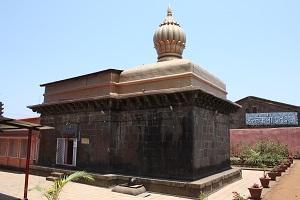
Shambhu Mahadev Mandir
Shambhu Mahadev Mandir is a historic Mandir located on Shambhu Mahadev Mountain in Shikhar Shingnapur, Maan taluka of Satara district. Set at an altitude of around 1,050 metres, the Mandir is reached by climbing nearly 400 steps through the forested slopes of the Sahyadri range. This site holds deep importance for bhakts across Maharashtra who regard Shambhu Mahadev as their kuldevta.
The Mandir houses two Shivlings, representing Shiv and Parvati. Its stone walls, intricately carved spire, and five large Nandi statues in the premises reflect architectural features from different periods. The Mandir is also associated with important historical figures—Maloji Raje Bhosale, grandfather of Shivaji Maharaj, is known to have visited regularly and constructed a reservoir, Shiv Tirtha, nearby to support yatris. The original Mandir is believed to have been established by Chakravarti Sindhandev Maharaj of the Yadav clan. It was later rebuilt under Chhatrapati Shahu Maharaj in 1735, with further restoration in the 20th century.
A distinctive feature of the Mandir is the Khadkeshwar Mandir further up the hill, notable for its large bells, including one donated by the British. Nearby are other religious sites such as the Amruteshwar Bali Mandir and Bhagirathi Kund.
The Mandir is the focal point of the Chaitra Yatra, a major annual festival marked by the symbolic marriage of Shiv and Parvati. A 550-foot pagote (rope), woven specially for the occasion, is tied between the kalash of the Shambhu Mahadev Mandir and the kalash of the nearby Amruteshwar Mandir during the marriage ceremony, held at midnight on Chaitra Shuddha Ashtami. This unique tradition highlights the enduring spiritual and cultural significance of the shrine.
Today, Shambhu Mahadev Mandir continues to draw visitors for its religious importance, architectural beauty, and deep connections to the Maratha legacy.
Shivaji Museum
Shivaji Museum in Satara is dedicated to preserving the cultural and historical legacy of the Maratha Empire, with a special focus on the life and times of Chhatrapati Shivaji Maharaj. Satara, once the capital of the Maratha kingdom, was ruled by his successors until 1839. The museum was established to preserve and exhibit the cultural legacy of the 17th and 18th centuries. Its foundation was laid in 1966, and the museum was inaugurated in 1970 by the then Home Minister of India, Yashwantrao Chavan, with the blessings of Shrimant Chhatrapati Sumitraraje Bhosale.

The museum is divided into two main sections: the Exhibition Gallery and the Maratha Art Gallery. The exhibitions are displayed across four sections: Weapons, Inscriptions, Paintings, and Textiles, giving visitors a glimpse into the life, artistry, and historical achievements of the Maratha era.
Tapola Lake
Tapola Lake, located near Mahabaleshwar in Satara district, is renowned for its scenic beauty and recreational activities. Often called the ‘Mini Kashmir of the West’, Tapola is surrounded by dense forests and offers panoramic views of the Sahyadri mountain range. The lake is formed by the backwaters of the Koyna River, creating a serene environment for visitors seeking peace and relaxation.
One of Tapola Lake’s key attractions is its proximity to the Koyna Wildlife Sanctuary, making it an excellent destination for wildlife enthusiasts and nature photographers. The sanctuary hosts a rich diversity of flora and fauna, including several rare and endangered species.
Tapola is also popularly known as the ‘boating capital of Maharashtra’, with its calm waters ideal for boating and water sports. The lake forms part of the Shivsagar Reservoir, which is associated with the Koyna Dam—the largest earthen dam in Maharashtra. Beyond its beauty, Tapola Lake plays a vital role in the region’s irrigation and hydroelectric power supply. It also serves as a connecting point between major tourist attractions like Mahabaleshwar and Pratapgad Fort.
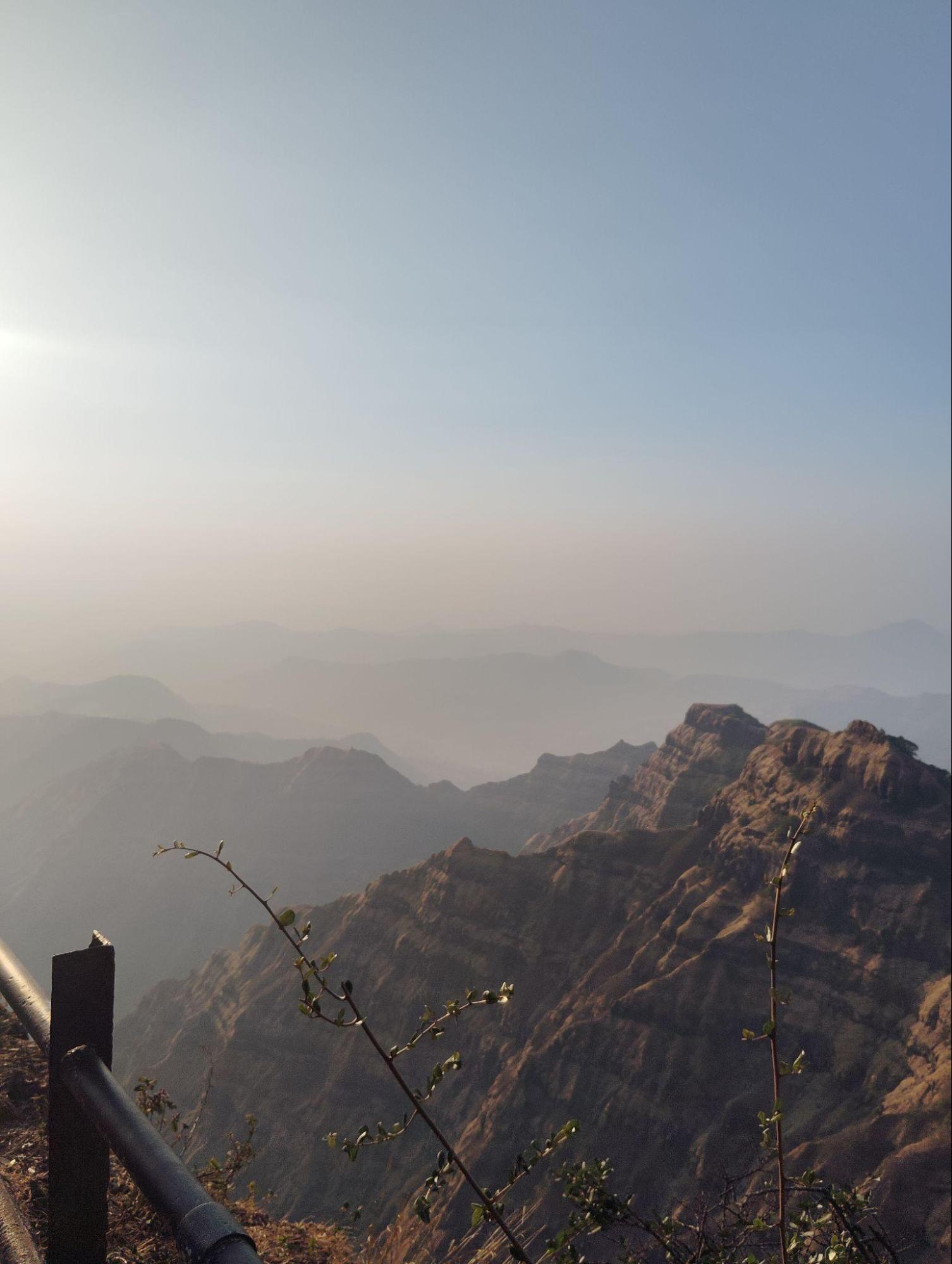
Vasota Fort
Vasota Fort, also known as Vyaghragad, is located near Bamnoli village within the Koyna Wildlife Sanctuary in Satara district. Surrounded by dense forests and steep cliffs, it holds both historical and cultural significance. According to the Satara District Gazetteer (1963), the fort is attributed to the Shilahara ruler Bhoja II (1178–1193) of Kolhapur. It later came under the control of the Shirkes and Mores before being captured by Chhatrapati Shivaji Maharaj in 1655 after his conquest of Javli, at which point he named it Vyaghragad.
The fort is also remembered for the story of Tai Telin, who is said to have defended Vasota for eight months against the Peshwa’s forces in 1806, during the imprisonment of her husband, Pant Pratinidhi, by Bajirao I. Eventually, the fort was taken by the British, likely during the Third Anglo-Maratha War.
During Shivaji Maharaj’s campaigns, Vasota served as a strategic base for resisting the Mughal forces. Its remote location in the forests of the Sahyadris provided natural defense and helped in launching surprise attacks. Apart from its historical importance, Vasota Fort is admired for its scenic surroundings within the Koyna Wildlife Sanctuary. The route to the fort passes through rich forests and varied landscapes, making it a popular trekking destination. Remains of bastions, water tanks, and small mandirs can still be seen, offering insight into Maratha fort architecture.
Locally, the fort is also linked to legends from the Ramayan, with some traditions believing that Bhagwan Ram stayed here during his exile. This association adds to the cultural significance of the site. Today, Vasota Fort attracts trekkers, nature enthusiasts, and history lovers who visit for both its breathtaking views and its connection to the region’s past.
Sources
Chavneshwar Mountain. 2020. Vikaspedia, Government of India.https://education.vikaspedia.in/viewcontent/…
Discovering Temples. Dolya Ganpati Mandir or Mahaganpati temple of Wai. Discovering Temples.https://discoveringtemples.com/temples-in-wa…
Dr S N Gaikwad. 2018. Historical Monuments in Satara. Review of Research, Vol 7, Issue10.https://oldror.lbp.world/UploadedData/10739.…
Explore The Rich Heritage of Maharashtra At Sangam Mahuli In 2025. 2024. Travel Triangle.https://traveltriangle.com/blog/sangam-mahul…
Government of Maharashtra. 1963. Satara District Gazetteer. Directorate of Government Printing, Stationery & Publications, Mumbai.
Government of Maharashtra. District Satara - Phaltan Taluka.https://www.satara.gov.in/en/tourist-place/p…
India.com. Pratapgad Fort. India.com.https://www.india.com/travel/pratapgad-fort/
India.com. Tapola. India.com.https://www.india.com/travel/tapola
India360. 2018. District Focus: Satara, Maharashtra. The Indian Adventure.https://india360.theindianadventure.com/2018…
Kevin Standage. 2017. Panchaganga Mandir, Mahabaleshwar. Kevin Standage Photography.https://kevinstandagephotography.wordpress.c…
Kevin Standage. 2019. Pateshwar Shiva Mandir Complex. Kevin Standage Photography.https://kevinstandagephotography.wordpress.c…
Kevin Standage. 2019. Sangam Mahuli. Kevin Standage Photography.https://kevinstandagephotography.wordpress.c…
Kinjal Dixit. 2022. Kashi Vishweshwar Mandir: The Embodiment of Simplicity in Wai. News Bharati.https://www.newsbharati.com/Encyc/2022/3/24/…
Mahabaleshwar Tourism. n.d. Rajpuri Caves, Mahabaleshwar. Mahabaleshwar Tourism.https://mahabaleshwartourism.in/rajpuri-cave…
Maharashtra Bhraman. Ajinkyatara Fort. MTDC.https://www.mtdc.co.in/forts/ajinkyatara-for…
Ministry of Culture. 2023. Char Bhinti Martyr Memorial, Satara. Azadi Ka Amrit Mahotsav.https://amritmahotsav.nic.in/district-reopsi…
Prerana Thakurdesai. 2012. Unprotected: 13th century Jabareshwar temple wastes away in oblivion as authorities sleep. India Today.https://www.indiatoday.in/magazine/offtrack/…
Rahul Gayakwad. 2025. Maharani Yasubai’s memorial now state-protected monument. The Times of India.https://timesofindia.indiatimes.com/city/kol…
Ravine Hotel. Strawberry Festival, Panchgani. Ravine Hotel.https://ravinehotel.com/strawberry-festival
Suresh Kumar Shah. 2023. Butterflies of Kaas valley, Maharashtra, India. Prommalia.https://www.biotaxa.org/Prommalia/article/vi…
The location of Maharani Yesubai’s tomb has finally been determined, important evidence has been found in this village in Satara. 2023. Maharashtra Times.https://marathi.indiatimes.com/maharashtra/s…
Tour My India. Panchgani Hill Station. Tour My India.https://www.tourmyindia.com/hill_stations/pa…
Unexplora. Valley of Flowers Tour at Kaas, Satara. Unexplora.https://www.unexplora.com/tours/visit-valley…
Vishwajeet Deshmukh. 2021. Phaltan Rajwada: A Hidden Gem of Maratha Architecture. Peepul Tree.https://www.peepultree.world/livehistoryindi…
Wikipedia Contributor. 2023. Santoshgad.https://mr.wikipedia.org/wiki/%E0%A4%B8%E0%A…
Wikipedia Contributors. 2025. Shikhar Shingnapur. Wikipedia.https://mr.wikipedia.org/wiki/%E0%A4%B6%E0%A…
Last updated on 22 July 2025. Help us improve the information on this page by clicking on suggest edits or writing to us.