Dharashiv
7,569 sq. km
~17.63 lakh (2019)
920 (2011)
~ ₹17,705 crore (2019)
~ ₹1.00 lakh (2019)
Dharashiv, earlier known as Osmanabad (named for the last Nizam of Hyderabad, Mir Osman Ali Khan) was part of Hyderabad State until 1948 before joining independent India. Geographically, Dharashiv lies on the Deccan plateau and features rivers like the Sina, Manjira, and Terna, while the Balaghat Range covers much of its hilly terrain. It is bordered by Beed, Latur, Solapur, Ahmednagar, Bidar, and Kalaburagi districts, and hosts the historic Dharashiv Caves, reflecting its rich culture and heritage, and also where the name comes from.
The etymology of “Dharashiv”, has many stories running. Some believe that a king named Shiv from Ter, an ancient trading centre, built this cave complex after a water source was found in the area (`Dhara’ in Marathi means a flow or stream of water). Few others claim that when the Dharashiv caves were built, two guards named Dhara and Shiv were deployed to guard them, hence the name `Dharashiv’. Situated in the southern part of Maharashtra, it was formerly known as Osmanabad before being renamed Dharashiv in 2023.
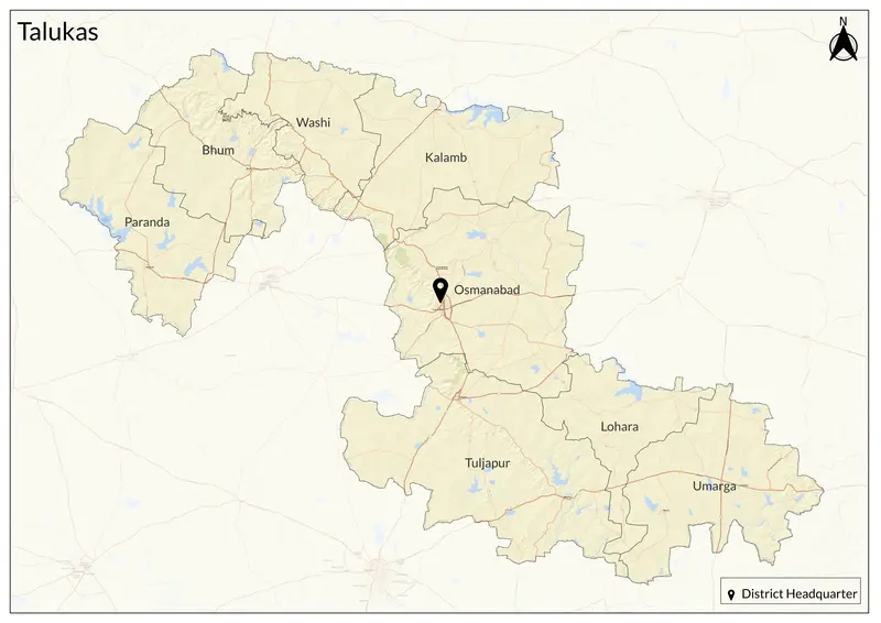
The region has been historically ruled by various dynasties, including the Mughals, Bahmani Sultanate, Nizam of Hyderabad, and the Adil Shahi dynasty. Under the Nizam's rule, the district remained part of Hyderabad State until its annexation in 1948. After Hyderabad's annexation, the district joined Bombay State and later Maharashtra in 1960. Today, the district comprises Osmanabad, Tuljapur, Omerga, Bhoom, Paranda, Kalamb, and Lohara talukas.
Dharashiv has many renowned cultural sites apart from the Dharashiv caves (whic have both Jain and Vaishnava caves frmo 7th century), including the Hatla Devi mandir, Naldurg Fort, Paranda Fort, Ramling mandir, Sri Yedeshwari mandir. Notaby, it has the mandir of Maa Tulja Bhawani, one of the most visited devi palace in the region. It also has Ter, a compelling archaeological site, whose antiquity is said to be dated as far back as the Puranas.
Geographically on the Deccan Plateau, Dharashiv experiences a semi-arid climate with scorching summers (up to 45°C), moderate monsoons (June–September), and mild winters. Its fertile plains and rocky terrain support agriculture, mainly growing jowar, bajra, sugarcane, and cotton. The Bhogavati River aids irrigation, merging with the Sina River in Solapur.
Their economy is predominantly agrarian, driven by crop cultivation and agro-industries, including sugar mills. Small-scale industries like textiles, handicrafts, and stone quarrying also contribute.
Explore Dharashiv