Contents
- Physical Features
- Climate
- Geology
- Nighoj Potholes (Parner Taluka)
- Soil
- Minerals
- Rivers
- Botany
- Wild Animals
- Birds
- Crustaceans (Crabs)
- Gubernatoriana waghi
- Forest Reserves
- Rehkuri Black Buck Sanctuary
- Kalasubai Harishchandragad Wildlife Sanctuary
- Maldhok Bird Sanctuary
- Kajwa Mahotsav
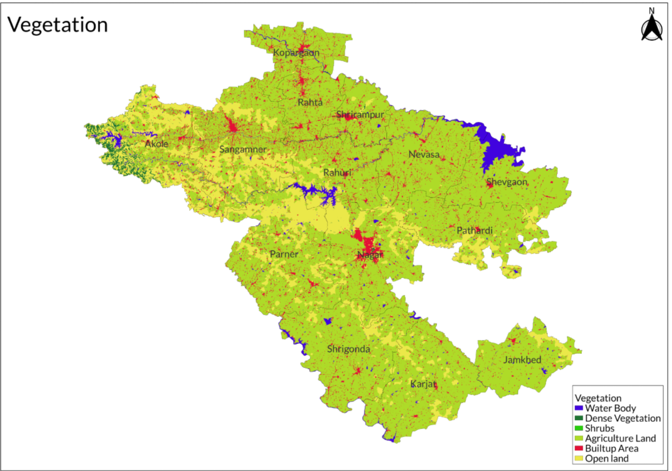
- Land Use
- Environmental Concerns
- Water Pollution
- Water Shortages
- Illegal Mining
- Deforestation
- Conservation Efforts
- Ralegan Siddhi Fast
- The Jai Hind Foundation
- Graphs
- Water
- A. Rainfall (Yearly)
- B. Rainfall (Monthly)
- C. No. of Rainy Days in the Year (Taluka-wise)
- D. Evapotranspiration Potential vs Actual Numbers (Yearly)
- E. Annual Runoff
- F. Runoff (Monthly)
- G. Water Deficit (Yearly)
- H. Water Deficit (Monthly)
- I. Seasonal Groundwater Levels: Bore Wells
- J. Seasonal Groundwater Levels: Dug Wells
- Climate & Atmosphere
- A. Maximum Temperature (Yearly)
- B. Maximum Temperature (Monthly)
- C. Minimum Temperature (Yearly)
- D. Minimum Temperature (Monthly)
- E. Wind Speed (Yearly)
- F. Wind Speed (Monthly)
- Forests & Ecology
- A. Forest Area
- B. Forest Area (Filter by Density)
- C. Wildlife Projects (Area and Expenses)
- Human Footprint
- A. Nighttime Lights
- Sources
AHILYANAGAR
Environment
Last updated on 6 November 2025. Help us improve the information on this page by clicking on suggest edits or writing to us.
Ahilyanagar district features a varied geographical landscape that includes the upper hill regions of the Sahyadri range and its three extensions, transitioning into the "mawal" area, and extending to the plateau of the Balaghat range along with its adjacent river plains. The activities and lifestyle of the local population are closely linked to differences in soil types, topography, water availability for agriculture, and the level of agricultural advancements that have transformed rural infrastructure.
Physical Features
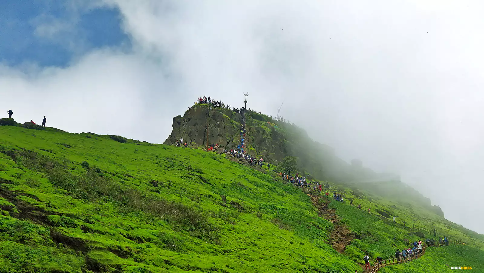
This region features rugged hills and valleys, contributing to the district's scenic beauty. In contrast, the central plateau region consists of more level terrain primarily found in the Parner and Ahilyanagar talukas, while the northern and southern plains are characterized by fertile agricultural land associated with river basins like those of the Godavari and Bhima rivers. The district's climate varies significantly; the western hilly areas experience cooler temperatures, while the eastern plains are typically hot and dry. Overall, Ahmednagar's geography plays a vital role in its agriculture and biodiversity, with forests in the hilly regions supporting various tree species, including teak and mango.
Climate
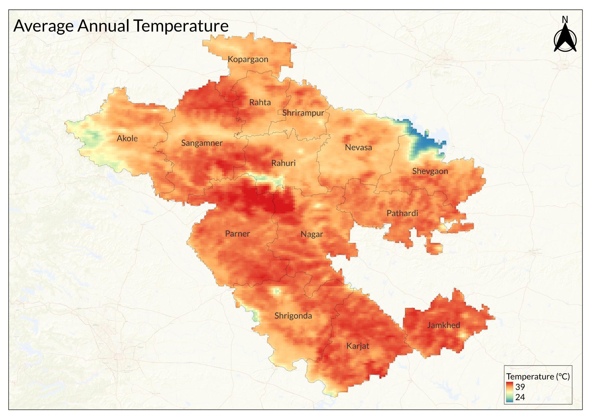
The current climate of the Ahilyanagar district is generally mild, with distinct seasons. From November to February, the weather is dry and refreshing. A hot wind from the northeast sets in until mid-May, leading to humid conditions until the southwest monsoon arrives in June, bringing cooler temperatures and rain. The monsoon typically ends by early October, although some local showers can occur later. Rainfall varies significantly across the district; areas near the Sahyadris receive over 150 inches annually, while plains often experience drought, especially in the Bhima basin.
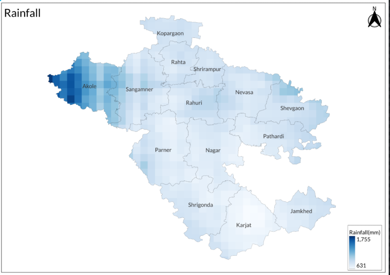
Historically, Ahilyanagar's climate has shown considerable variability in rainfall and temperature. The average annual rainfall is about 21 inches, with significant fluctuations from year to year. For example, 1869 recorded the highest rainfall at 47 inches, while some years saw as little as 5 inches. January and February are usually dry months, while July and September often bring heavy rains. The hottest month is May, with temperatures reaching up to 45°C, while December is the coldest, with lows around 40°F. These historical patterns highlight the unpredictable nature of rainfall and temperature in the region over time.
Geology
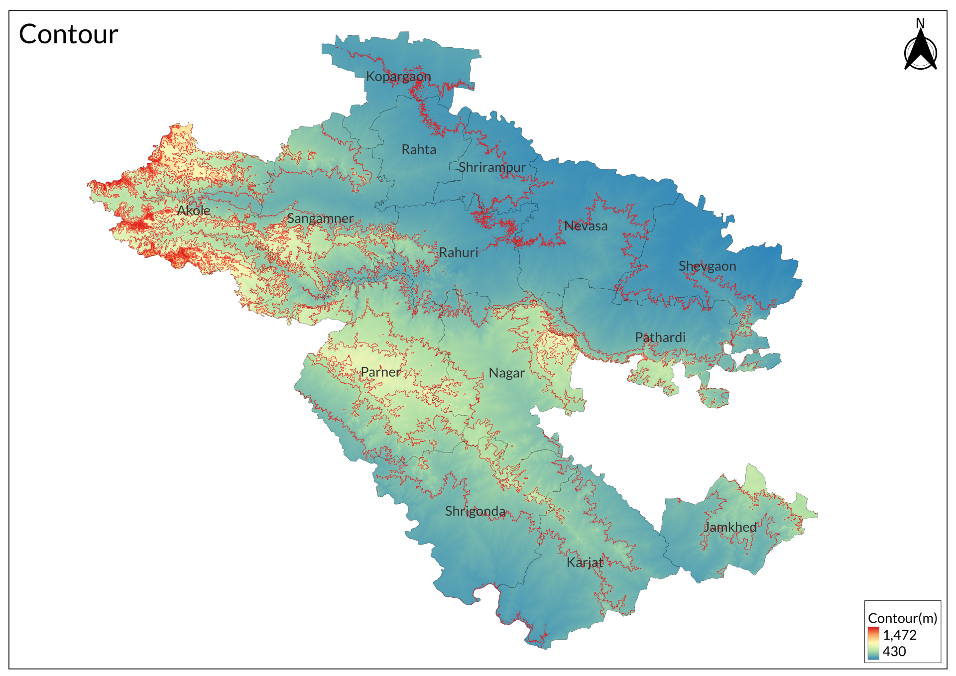
The District Gazetteer of 2003 describes the geology of the district, which is part of the larger Deccan Traps region. The area is mainly made up of layered basalt and amygdaloid rocks that appear horizontal but dip slightly to the east. Notable limestone formations can be found on the Kanhur plateau, especially in the Wadgaon-Darya area, where the cliffs are shaped by water erosion and adorned with stalactites and ferns.. The western edge of the district features cliffs that drop dramatically from the Sahyadri mountains to the Konkan region, with some cliffs reaching heights of 3,000 feet.
The geology includes various rock formations such as columnar basalt, which can weather into unique shapes like pillars and spires. In places like Kothul, there are thick layers of gray basalt topped with a mandir. The district also has round or oval masses of basalt known as nodular basalt, found at different elevations. Vertical basalt dykes run through the rock layers without causing any significant disruption. Additionally, red ochreous clay layers are present beneath the basalt, contributing to the area's rich soil.
Nighoj Potholes (Parner Taluka)
In Nighoj village, Parner taluka, Ahmednagar district, 90 km from Pune, the Nighoj Potholes along the Kukadi River form a striking natural wonder, among Asia’s largest of their kind. These smooth, round cavities, carved into the basalt riverbed over millennia by water and pebbles, stretch over 3 km, with some reaching depths beyond 100 feet. The landscape, with black and dark grey rocks accented by red hues and green-white marble layers, creates an otherworldly scene.
Geologists attribute the potholes to heavy ancient rainfall, when the Kukadi River surged from the highlands, scouring the basalt. Pebbles trapped in cracks, swirled by water, drilled out these pot-shaped hollows. Locals call them Kund, attributing their creation to Malganga, honored at a riverside Mandir. Nearby potholes bear names like Ram Kund, Sita Kund, Lakshman Kund, and Hanuman Kund, rooted in local tales. The Mandir and potholes draw hundreds annually, including global geologists studying their formation.
Nighoj village, vibrant with colorful houses, mandirs, and eateries serving Maharashtrian bhaji and roti, feels lively yet off the tourist trail. An old stepwell, or baarav, stands in the village center, though poorly maintained. Accessible from Pune by a two-hour drive through wheat and sugarcane fields, or by bus to Shirur followed by a rickshaw (Rs 600 per day), Nighoj is best visited from November to April when low river levels reveal the potholes. Monsoons obscure them, but the rushing water adds drama. A suspension bridge and concrete walkway with viewpoints ensure safe exploration, though the smooth edges can be slippery.
Soil
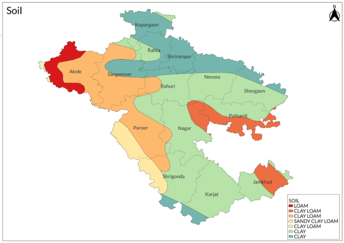
The district primarily comprises three soil categories: fertile alluvial soils found along riverbanks, black stone mixed soils prevalent on hill slopes, and white limestone mixed soils mainly in the Parner taluka. Chemical analyses reveal that the soils generally have an alkaline pH ranging from 8.0 to 9.7 and exhibit a high cation exchange capacity (CEC), indicating a clay loam to clay texture rich in smectite. However, environmental factors such as industrial development and intensive agriculture, particularly sugarcane cultivation, have negatively impacted soil quality, leading to issues like waterlogging and declining health due to improper irrigation practices.
Minerals
Ahilyanagar is rich in mineral resources, primarily due to its geological composition dominated by basalt from ancient volcanic activity associated with the Deccan Traps. The district features significant deposits of limestone, particularly in the Pravara Basin, which enhance soil fertility and are extensively used in construction. Additionally, clay is found in riverbeds and utilized for pottery and brick-making. The alluvial deposits along the Godavari and Bhima rivers provide essential materials for agriculture. Basalt serves as a durable aggregate in construction projects. Notably, the region also has unique geological formations, such as potholes in rocky river beds, particularly in areas like Nighoj, showcasing the diverse geological features of Ahilyanagar.
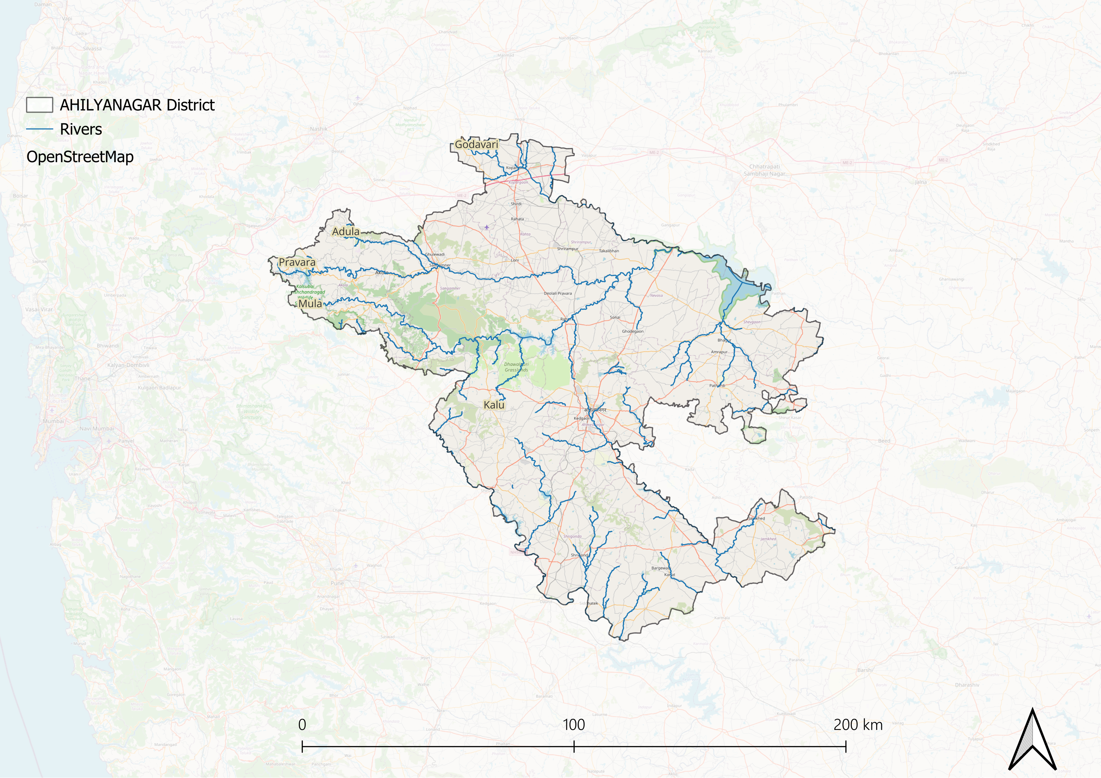
Rivers
Ahilyanagar district is primarily drained by two major rivers: the Godavari and the Bhima, with the watershed line defined by the Sahyadri mountain range. The Godavari, which is the more significant of the two, originates near Trimbak in Nashik and flows through various sub-divisions including Kopargaon, Sangamner, and Akola. It receives several tributaries such as the Banganga, Kadva, and Darna as it progresses southeast through fertile alluvial plains. Its waters are believed to purify sins, making it a space where many come to bathe and perform rituals for their deceased relatives. The river's banks vary from steep and cultivated to sloping and barren.
The Bhima River drains the southern part of Ahilyanagar, forming a natural boundary with Pune district before continuing southeast into Karnataka. It receives significant tributaries like the Ghod and Sina, which contribute to its flow. The Ghod rises in the Sahyadris and flows for over fifty miles, while the Sina has two main sources near Ahilyanagar. Both rivers support local agriculture through irrigation, although their flow diminishes during dry months. The region also features smaller streams that provide seasonal water but lack substantial storage infrastructure for monsoon runoff. Despite this, well irrigation is prevalent in northern areas, ensuring year-round cultivation of gardens and crops.
Botany
Ahilyanagar district is known for its botanical diversity, particularly its medicinal plants. Notable examples include drumstick, used for its nutritional and medicinal properties; the Peepal tree, a sacred tree in Hinduism; and bael, which aids digestion. Other important plants include jujube, valued for its health benefits, black plum, recognized for its anti-diabetic properties, and sandalwood, used for its aromatic wood and oil. The district also includes field pumpkin and melon, which are part of local diets and traditional medicine.
Wild Animals
Outside the sanctuaries, the Ahilyanagar district is home to a variety of wild animals that inhabit its diverse landscapes. Notable species include leopards, which are prominent predators in the region's forests and grasslands, and jungle cats, commonly found in scrubland. Wild boars are frequently seen in agricultural areas, while sloth bears occasionally roam wooded regions. Barking deer inhabit scrub and forested areas, and chinkaras, or Indian Gazelles, thrive in open grasslands. The Indian fox is adaptable to various environments, including rural settings, and hyenas can also be found scavenging in some parts of the district.
According to locals, in the late 19th and early 20th centuries, a legendary Bengal tiger known as "Baba" roamed the forests of the Ahilyanagar district. Known for his exceptional size and strength, Baba became a prominent figure in local folklore. He was both feared and respected by the local communities, and his encounters with British hunters became the stuff of legend.
Birds
Notable resident birds include peafowl, known for their striking plumage, and partridges, commonly found in open fields and grasslands. The area also attracts several migratory birds during specific seasons, such as the colorful Indian Roller and various waders. Birds of prey, including eagles and kites, further indicate a healthy ecosystem.
Crustaceans (Crabs)
Gubernatoriana waghi
Ghatiana waghi is a striking orange-colored crab with ivory-hued legs, discovered in October 2014 by zoologist Prashant Wagh, after whom the species is named. The crab was first observed in the Ahilyanagar district of Maharashtra, specifically beneath small rocks at the edge of a cliff in the Harishchandragad region, a part of the Western Ghats known for its rich biodiversity.
Like several other species in the Ghatiana genus, G. waghi displays asymmetrical pincers, with the right claw noticeably larger than the left. The claw fingers of the larger pincer are marked by two or three prominent teeth, which create a wide gap when the claw tips meet. This structural feature likely aids in gripping prey, manipulating food, and may also play a role in territorial or mating displays.
With its vibrant coloration and distinctive morphology, Ghatiana waghi adds to the growing list of freshwater crab species unique to the Sahyadri range and highlights the importance of conserving these fragile cliffside and forest ecosystems where such rare species continue to be found.
Forest Reserves
Rehkuri Black Buck Sanctuary
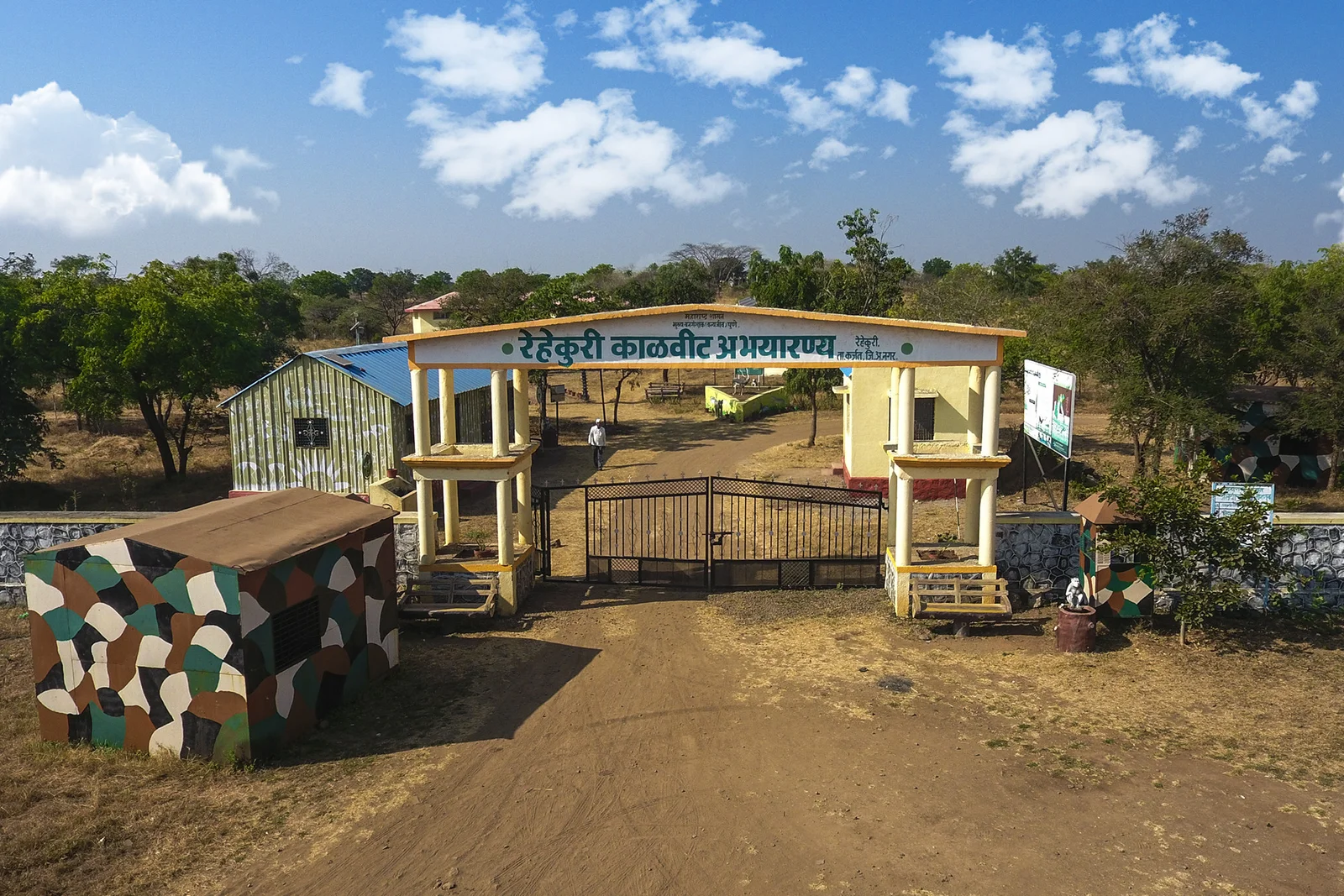
This sanctuary, covering an area of 2.17 square kilometers, is dedicated to the conservation of the Indian Black Buck, a species known for its distinctive appearance and rarity. The sanctuary is estimated to host around 400 to 500 black bucks and is open year-round, with the best visiting time during the summer season.
Kalasubai Harishchandragad Wildlife Sanctuary
Another important area is the Kalasubai Harishchandragad Wildlife Sanctuary, situated in the Sahyadri hill ranges. This sanctuary is home to various mammals, including leopards, jungle cats, hyenas, wolves, jackals, and deer species like barking deer and sambar. The sanctuary also supports a variety of reptiles and birds, enhancing its biodiversity. The sanctuary's vegetation includes various trees and shrubs such as Chandawa, Beheda, Avali, Gulchavi, Kharvel, Siras, Aashind, Parjambhual, Hirda, and Lokhandi trees.
Maldhok Bird Sanctuary
Maldhok is a beautiful bird found in the Karjat, Shrigonda, and Newasa talukas of Ahilyanagar district. The bird can only be spotted in these specific areas and nowhere else in the Ahilyanagar district. This region has been declared a sanctuary for these birds and occupies nearly 300 hectares.
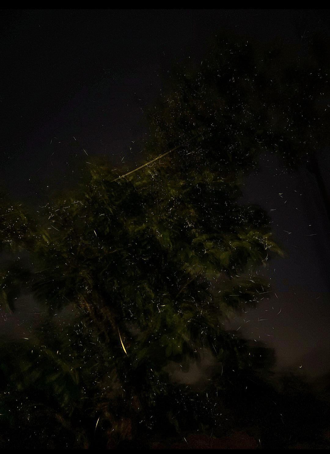
Kajwa Mahotsav
Bhandara, in Akole Taluka, is highly famous for the 'Kajwa Mahotsav' or Firefly Festival, an annual event that takes place in May and June. During these two months, visitors have a unique opportunity to witness the natural phenomenon of fireflies in abundance. As the sun sets and darkness blankets the surroundings, the fireflies illuminate the landscape, creating a captivating spectacle of twinkling lights.
Land Use
Environmental Concerns
Water Pollution
A study found that the Godavari River in the Puntamba Gaon area is heavily polluted because of waste dumping, washing clothes, and factory wastewater. Harmful chemical levels were very high, with Chemical Oxygen Demand (COD) at 169 mg/l and Biological Oxygen Demand (BOD) at 34.50 mg/l. COD shows how much oxygen is needed to break down chemicals, so high COD means a lot of pollution. BOD shows how much oxygen bacteria need to break down waste, and high BOD means there is a lot of sewage and other waste. These high levels make the river one of the most polluted. Even though water hardness was safe at 72 mg/l, the high COD and BOD levels are dangerous for fish and other aquatic life because they reduce the oxygen in the water.
The Sina River is also badly polluted by sewage, factory waste, and dirty water. Harmful chemicals like COD and Total Dissolved Solids (TDS), along with chlorine and phenol, were found at high levels. TDS measures all the dissolved substances, including salts and chemicals, and high TDS means the water is unsafe. Chlorine from industrial waste and phenol from pollution are harmful to fish and humans. The river also has low Dissolved Oxygen (DO), meaning there’s very little oxygen in the water, making it hard for fish and other aquatic life to survive. Both rivers are getting more polluted over time.
Water Shortages
In addition to conservation efforts, residents of Ahilyanagar have recently protested against water supply issues. In May 2024, citizens expressed frustration over the administration's introduction of 312 water tankers, primarily operating in Pathardi taluka, which often failed to deliver water consistently, sometimes delaying deliveries by up to 5-6 days. A protest was staged by residents of Pagori Pimpalgaon directly at the tehsil office, demanding immediate improvements to water supply services. Although officials provided written assurances, protests continued as citizens sought accountability and action.
Illegal Mining
Illegal stone mining and crushing activities in the eco-sensitive zone of the Great Indian Bustard (GIB) sanctuary in Ahilyanagar district, Maharashtra, have led to significant environmental degradation and adversely affected local water sources. Despite a National Green Tribunal (NGT) order prohibiting such activities, residents from nearby villages report that illegal mining continues unchecked.
The GIB sanctuary, located in Shrigonda taluka, is designated as an eco-sensitive area where no human-related activities are permitted within a 10-kilometer radius. However, the ongoing illegal mining operations have severely damaged the environment and threatened the habitat of this nearly extinct bird species.
Vinaykumar Jathar, who filed a complaint with the NGT in 2019, noted that permissions for stone mining were originally granted in 1994 for a single block of land. However, these permissions have been misused over the years, leading to extensive environmental harm without adequate enforcement of regulations. Jathar reported that numerous complaints from farmers and villagers have been lodged with local authorities, yet no effective action has been taken to mitigate the situation.
Local farmers like Baykar Datta have experienced firsthand the detrimental effects of mining activities. Datta lost his primary water source due to contamination and depletion caused by nearby mining operations. Similarly, Machindra Dange reported that dust from mining has settled on his crops, rendering them unfit for harvest and contributing to declining yields. Health issues related to respiratory problems have also emerged among community members, which they attribute to dust pollution from these activities.
Experts emphasize that even areas with less vegetation are crucial for biodiversity and must be preserved. The GIB requires quiet and secluded environments for its survival, making the disturbances from mining operations particularly harmful.
Despite repeated appeals to authorities, residents discovered through Right To Information (RTI) requests that many mining activities were being conducted illegally. Investigations revealed that only one of the twelve blocks where mining occurred had received official approval, and even that permission had expired.
The NGT ordered an inquiry into these allegations and confirmed the illegal nature of the mining activities, directing immediate action against violators. However, local officials claimed that only one site was operational at the time of the NGT's orders and insisted that all work had ceased following those directives.
Deforestation
Deforestation in Ahilyanagar district, Maharashtra, is driven by several factors, including agricultural expansion, construction activities, and population growth. As of 2023, the district has approximately 1,994 square kilometers of forest area, which constitutes about 11.7% of its total geographical area of 17,048 square kilometers. However, this forest cover is under significant threat due to various human activities.
Agriculture plays a major role in deforestation as villagers clear land for paddy fields and other crops to meet the demands of a growing population. Additionally, construction projects for housing, roads, and infrastructure lead to the clearing of trees and natural habitats. The increasing population further exacerbates the problem, as more land is needed for residential and commercial purposes. Moreover, certain areas in Ahilyanagar are prone to drought, which can negatively impact vegetation and contribute to land degradation.
Conservation Efforts
Ralegan Siddhi Fast
The region has a history of activism related to environmental issues. For instance, on August 1, 1999, social activist Anna Hazare initiated a silent fast at Ralegan Siddhi to protest against government inaction regarding a drought scandal involving officials from the soil conservation department in Ahilyanagar. Hazare threatened to escalate his protest if no action was taken against those responsible.
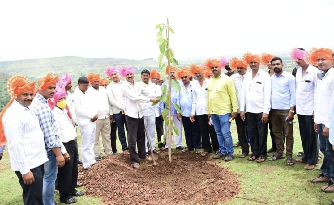
The Jai Hind Foundation
The Jai Hind Foundation, established in 2017 by ex-army soldier Shivaji Palve, is a non-governmental organization focused on forest conservation and environmental awareness. To date, the foundation has successfully planted 12,900 trees across 55 villages in the Ahilyanagar district. One of their most notable initiatives involved planting 500 Banyan trees in the shape of a Shiva Linga at the Kolhubai Mata Gadh near the Mahadev Temple, located on a hill known as Garbhagiri Vadrai. Palve stated, “The trees are planted in the shape of the Shiva Linga which is located at the center of the area”.
The Jai Hind Foundation operates with a small team of 10-12 people and faces several challenges:
- Public Apathy: There is a significant lack of engagement from citizens regarding environmental initiatives. Palve noted, “People complain about the hot weather in Ahilyanagar and say that everyone should plant trees, but when it comes to contributing their time, efforts, or funds for this cause, they suddenly lose interest”.
- Limited Media Coverage: The foundation struggles with insufficient media attention, which results in many residents of Ahilyanagar being unaware of their activities and impact.
Graphs
Water
Climate & Atmosphere
Forests & Ecology
Human Footprint
Sources
ABP Majha. 2024.Ahmednagar Water Shortage: Villagers Protest. ABP Majha, Maharashtra.https://marathi.abplive.com/videos/news/maha…
Collector Office Ahmednagar. District Profile of Ahmednagar. Ahmednagar District Website, Ahmednagar.https://ahmednagar.nic.in/en/about-district/…
Collector Office Ahmednagar. n.d.Geography of Ahmednagar. Ahmednagar District Website, Ahmednagar.https://ahmednagar.nic.in/en/about-district/…
Collector Office Ahmednagar. Rehkuri Black Buck Sanctuary. Ahmednagar District Website, Ahmednagar.https://ahmednagar.nic.in/en/tourist-place/r…
Government of Maharashtra. 1884 (Reprinted in 2003, e-Book Edition 2006). Gazetteers of the Bombay Presidency: Ahmadnagar District, Volume XVII. Gazetteer Department, Government of Maharashtra, Mumbai.https://gazetteers.maharashtra.gov.in/cultur…
Himanshu Nitnaware. 2020.Illegal Industrial and Mining Activities Continue in Great Indian Bustard's Habitat in Maharashtra. 101 Reporters, Maharashtra.https://101reporters.com/article/environment…
Homegrown. Maharashtra’s Best-Kept Geological Secret: The Potholes of Nighoj.Homegrown. Accessed March 17, 2025.https://homegrown.co.in/homegrown-explore/ma…
India Environment Portal. 1999.Silent Protest. India Environment Portal, New Delhi.http://indiaenvironmentportal.org.in/content…
Pandurang Thombare. September 2022.Problems of Urbanization in Ahmednagar District with Special Reference to Ahmednagar City (M.S.). ResearchGate.https://www.researchgate.net/publication/363…
Richa Malhotra. 2016.Meet the Western Ghats’ Wonderful New Freshwater Crabs.Science The Wire.https://science.thewire.in/science/meet-the-…
Vivek Buddha. Ahmednagar District Information. Medlala, Ahmednagar.https://medlala.com/districts/ahmednagar/
Wikipedia. Ahmednagar District. Wikipedia, Ahmednagar.https://en.wikipedia.org/wiki/Ahmednagar_dis…
Last updated on 6 November 2025. Help us improve the information on this page by clicking on suggest edits or writing to us.