Contents
- Physical Features
- Geology
- Soil
- Minerals
- Rivers
- Lonar Lake
- Botany
- Wild Animals
- Birds
- Forest Reserves
- Amababarwa Wildlife Sanctuary
- Gyan Ganga Wildlife Sanctuary
- Land Use
- Environmental Concerns
- Deforestation
- Water Scarcity
- Climate Change Vulnerability
- Conservation Efforts/Protests
- Lonar Lake
- Khamgaon Forest Conservation
- Ban on Paper Cups
- Graphs
- Water
- A. Rainfall (Yearly)
- B. Rainfall (Monthly)
- C. No. of Rainy Days in the Year (Taluka-wise)
- D. Evapotranspiration Potential vs Actual Numbers (Yearly)
- E. Annual Runoff
- F. Runoff (Monthly)
- G. Water Deficit (Yearly)
- H. Water Deficit (Monthly)
- I. Soil Moisture (Yearly)
- J. Seasonal Groundwater Levels: Bore Wells
- K. Seasonal Groundwater Levels: Dug Wells
- Climate & Atmosphere
- A. Maximum Temperature (Yearly)
- B. Maximum Temperature (Monthly)
- C. Minimum Temperature (Yearly)
- D. Minimum Temperature (Monthly)
- E. Wind Speed (Yearly)
- F. Wind Speed (Monthly)
- G. Relative Humidity
- Forests & Ecology
- A. Forest Area
- B. Forest Area (Filter by Density)
- C. Wildlife Projects (Area and Expenses)
- Human Footprint
- A. Nighttime Lights
- Sources
BULDHANA
Environment
Last updated on 6 November 2025. Help us improve the information on this page by clicking on suggest edits or writing to us.
Buldhana experiences a climate that varies from semi-arid to tropical, which fosters a diverse range of flora and fauna. Although agriculture is the primary land use in the area, it faces significant environmental challenges, including deforestation, soil erosion, and water scarcity. These issues have arisen as a result of escalating human activities and shifting climate patterns.
Physical Features
Buldhana District is the westernmost district of the Vidarbha region in Maharashtra, spanning an area of 9,661 sq. km and situated at an altitude of 639 m above mean sea level. The district is bordered to the north by the Amravati and Burhanpur districts of Madhya Pradesh, to the east by Akola and Washim districts, to the south by the Parbhani and Jalna districts, and to the west by the Jalgaon and Aurangabad districts.
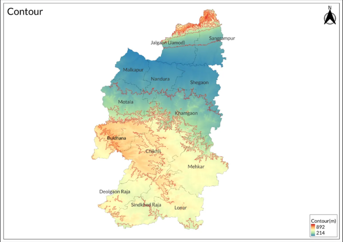
The district is divided into 13 tahsils, namely Buldhana, Chikhali, Mehkar, Lonar, Deulgaon Raja, Sindkhed Raja, Motala, Malkapur, Nandura, Khamgaon, Shegaon, Jalgaon Jamod, and Sangrampur. The northern part of the district features a section of the Satpura Range, with elevations ranging between 700 and 1,000 m. Other prominent hills near the Satpura Range include Chandgarh Hill (743 m), Dhormorya Hill (837 m) near Bhimgara in the Raipur reserved forest area, and Pimpaldoh Hill (928 m). The Amba Barwa Wildlife Sanctuary is located south of this range.
The Buldhana plateau extends from the southern to the central part of the district. The edge of this plateau overlooks the Purna plains to its north and is characterized by a hilly ghat region with average elevations of 500 to 600 m. The southern edge of the Buldhana plateau slopes gently down to the Dudna and Godavari valleys, dropping by 100 to 150 meters as it curves from west to east and then southeast.
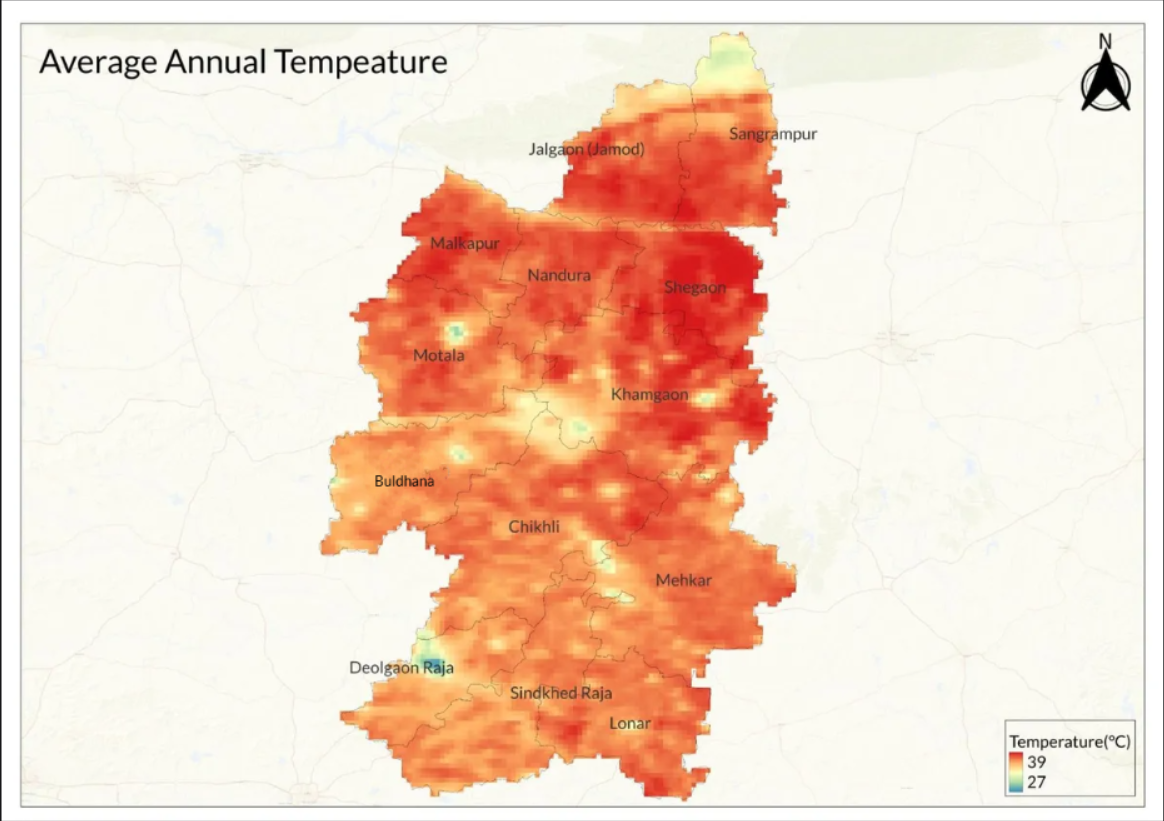
Buldhana District experiences tropical dry weather for most of the year, with average temperatures varying between 27°C and 35°C. The district is characterized by hot summers from March to May, with May typically being the hottest month, averaging a maximum temperature of 37°C. Winter sets in from December and lasts until February, with January being the coldest month, averaging a minimum temperature of 20°C.
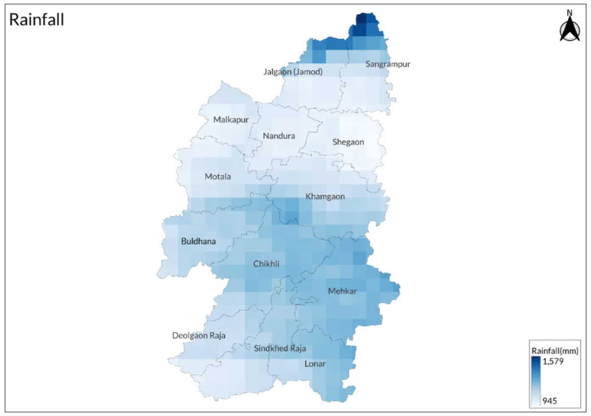
The monsoon season occurs from June to September, with an average rainfall of 210 mm. The southwest monsoon lasts from June to September, while October and November constitute the post-monsoon season, receiving an average rainfall of 140 mm.
Geology
Only two geological formations are known to occur: the Purna Alluvium and the Deccan Traps. The majority of the district is covered by the Deccan Trap, a vast expanse of volcanic basalt rock, while the alluvial plain occupies a stretch of low-lying ground where the Purna River crosses the northern part of the district.
The Deccan Trap is characterized by its layered basalt flows resulting from volcanic eruptions that occurred approximately 65 million years ago. This formation plays a significant role in shaping the region's landscape and soil characteristics. In contrast, the Purna Alluvium consists of sediments deposited by river action, providing fertile soil that supports agriculture in the area.
Soil

The soils in the district are derived from trap rock of volcanic origin. There are three main categories of soils in the district: (i) Bharkali, which is deep black soil with a very fine texture; (ii) Murmad, which is black cotton soil containing lime and is less fertile than pure black cotton soil; and (iii) Barad, which consists of shallow soil found in the higher lands of the plateau, exhibiting black, brown, and reddish colors.
Minerals
The district is not rich in major mineral resources, possessing only a few deposits of agate (semiprecious stones). The district does have some minor minerals available, such as brick soil, sand, and boulders.
Rivers
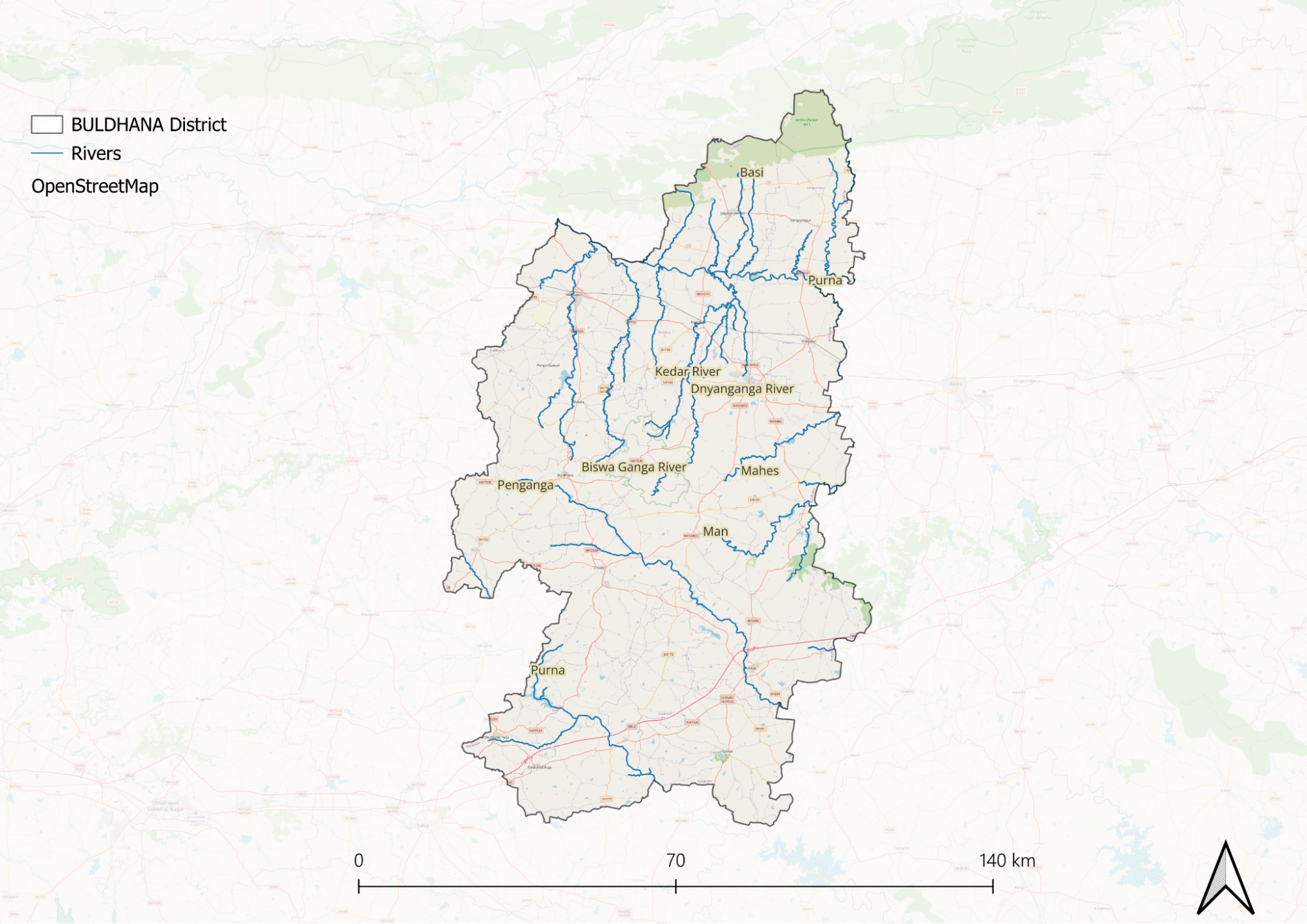
Most of the Chikhli and Mehkar tahsils fall within the drainage area of the Penganga. The river has only a seasonal flow and is dry during hot weather. Its valley appears open, broad, and shallow. The Katepurna, also known as the South Purna, rises in the Ajanta ranges but is located outside the district limits in Aurangabad. It enters Buldhana near the village of Chinchkhed in Chikhli Tehsil and flows generally southeast through the southern parts of Chikhli and Mehkar Tehsils. It runs for about 50 km in the southern part of the district before exiting into Parbhani. Although it is also a non-perennial stream, it flows for a longer period than the Penganga.
Both the Penganga and Katepurna are important left-bank tributaries of the Godavari River, but they gain significance only after leaving the district limits. The Purna, the only perennial stream in the Payanghat plains, rises in the south-facing scarps of the Gawilgarh hills in the Amravati district. It flows across the northern part of Buldhana to join the Tapi River in Jalgaon district. Numerous streams rising from both its northern and southern scarps join this river, creating a fairly dense drainage network throughout the region. The drainage pattern is primarily dendritic, although some streams exhibit sub-parallel drainage to the main river before their confluence in the aggraded valley floor.
Lonar Lake
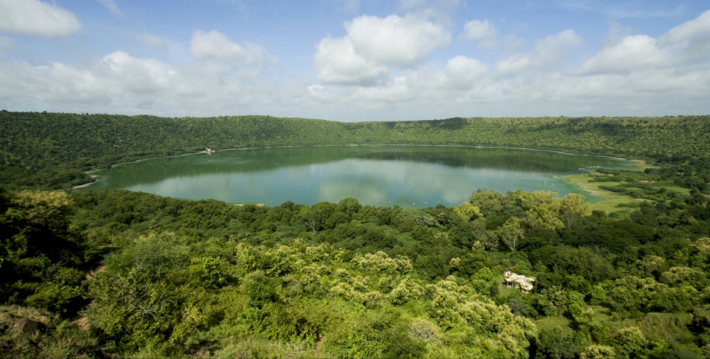
Post-independence, a survey conducted by the Geological Survey of India in 1975 used carbon dating to determine that the lake is approximately 58,000 years old, formed by a meteorite impact. It is one of the world's largest basaltic impact craters, holding both scientific and touristic significance. The lake reaches a depth of around 150 m, with the entire crater spanning about 1,800 m in diameter from rim to rim. Covering an area of approximately 78 hectares (193 acres), Lonar Lake experiences dramatic color changes from green to pink due to blue-green algae and spirulina algae found on its surface, influenced by its high salinity, alkalinity, and seasonal variations. These microorganisms, including Dunaliella salina, produce pigments that cause color shifts, making the lake a subject of scientific interest and a popular tourist destination.
Lonar Lake is the only meteorite-formed lake containing alkaline water with a pH of 10.7, significantly saltier than seawater, and it hosts plant species unique to the area. Leopards have been sighted near the lake. There are a total of 14 temples in the vicinity, with the Daityasudan temple, dating back to the 9th century and resembling the Khajuraho temples, being particularly noteworthy.
Botany
Timber and firewood trees are predominantly found near forest areas in the district. Notable species include teak, salai, ain, tendu, palas, babul, and lendia, all of which are integral to the district's timber forests. Teak stands out for its prevalence and is often accompanied by dhaora in mixed forests. Additionally, species such as khair, mokha, mahua, neem, and jamun trees are present throughout the district.
Bamboo species like Dendrocalamus strictus and Bambusa arundinacea are particularly found in the Ambabarwa Forest Reserve. The presence of bija, haldu, and harra further enriches the forests, providing resources for traditional medicine, timber, and other local uses.
Wild Animals
Malkapur tehsil is home to various wildlife, including rabbits, foxes, and tigers, which are usually confined to remote hilly areas and dense forests. The most favorable habitats for tigers and panthers are the Ambabarwa reserved forest area and the Matargaon reserved forest area, respectively. Panthers vary in size from small to fairly large. The sloth bear, locally known as bhalu, is rare in this district and is primarily found in cut-up valleys with cool hiding places in the Ambabarwa reserved forest area of the Jalgaon range.
Nilgai are common throughout the district and can be found in open forests. Sambars, chital, and wild boars are also present in the forests across the district, particularly in the larger blocks of Ambabarwa.
Birds
The common bird species observed in the district include the green pigeon and blue rock pigeon. According to the British gazetteer of 1910, the number of pigeon species was abundant and remains significant even after 100 years. Water birds such as brahminy ducks and cranes can be found near the Purna River.
In the Ambabarawa Forest Reserve, one can find peafowl, kabutar, black partridge (kala teetar), painted partridge, grey partridge, grey quail, rain quail, and batar.
Forest Reserves
Amababarwa Wildlife Sanctuary
In the Satpura mountain range of the district, the Ambabarwa Sanctuary, located in the border areas of Madhya Pradesh and Melghat, is a boon for natural diversity, and this sanctuary is known as the main forest tourist center of the district. The Sanctuary is home to the Bengal Tigers. The sanctuary is also famous for other wildlife species like Indian jackals, wolves, leopards, and bears.
Gyan Ganga Wildlife Sanctuary
The Gyan Ganga Wildlife Sanctuary is located 24.8 km from Buldhana city in Khamgaon, covering an area of 205 sq km. It is situated in Buldhana District, near the Dnyanganga River. The sanctuary is home to leopards, sloth bears, barking deer, blue bulls, spotted deer, hyenas, jungle cats, and jackals, which enhance its appeal. Approximately 150 species of birds can also be observed in the sanctuary. The terrain is undulating and interspersed with hillocks that have gentle slopes.
Managed by the Office of the Field Director of the Melghat Tiger Reserve under the Maharashtra Forest Department, the sanctuary serves as a natural habitat for various animal and bird species, many of which are seasonal migrants from different parts of the country. According to the British Gazetteer of 1910, during the fourteen years ending in 1907, an average of three people were killed annually by wild animals.
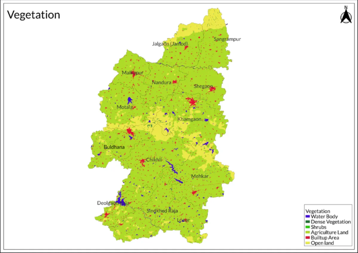
Land Use
Environmental Concerns
Deforestation
Deforestation in the Buldhana district, Maharashtra, has become a pressing environmental issue.
As of 2010, Buldhana had only 217 hectares of tree cover, which accounted for less than 0.1% of the district's total land area. Overall, the forest area represents approximately 16.41% of Buldhana's geographical expanse. The management of this forest area is divided between two departments: the Forest Department oversees 1217 sq. km, while the Revenue Department manages an additional 388 Sq. km. The Buldhana Forest Division is integrated within the Amravati Forest Circle. To protect wildlife, government directives have been established to ensure that drilling activities do not negatively impact the forest ecosystem.
Water Scarcity
Water scarcity in Buldhana district, Maharashtra, has become a critical issue, exacerbated by prolonged drought conditions and ineffective management of water resources.
Residents recall that the last significant rainfall occurred in 2012, with the district now experiencing chronic dry spells that have worsened over the years. The drought peaked in 2019, leading to a socio-economic crisis characterized by increased migration as agricultural profits dwindled and job opportunities for farm laborers diminished. Many locals have been forced to abandon farming altogether, seeking work as low-wage laborers in cities such as Mumbai, Pune, Surat, and Vadodara. The Indian Meteorological Department has classified Buldhana and the surrounding areas as suffering from severe rainfall deficits. This situation has led to a notable increase in migration, with even small and marginal farmers leaving their homes due to the harsh realities of life in the district. Reports indicate that entire families are relocating to urban areas in search of better employment opportunities, often living in substandard conditions.
In Isoli village, for instance, many residents are now travelling to Pune for work after abandoning their farms. One villager expressed that the minimal earnings from farming were insufficient compared to what he could make as a security guard in the city. The Brahmanwada reservoir, once a vital water source for the village, has not been filled since 2006 and is now completely dry, forcing residents to rely on water tankers.
The situation is similar across various villages in Buldhana, where agricultural wages have plummeted to Rs 60 per day, prompting many workers to seek better-paying jobs in urban centres. Data from the state government indicates that Buldhana has experienced below-normal rainfall for 11 out of the last 23 years. The most severe deficit occurred in 2018 when rainfall was reported to be 44% below the average. Overall, even accounting for years of excess rainfall, the average precipitation since 2000 remains below normal levels.
Climate Change Vulnerability
Buldhana district in Maharashtra is identified as one of the areas highly vulnerable to the impacts of climate change, according to a recent study. This research highlights that 77% of Maharashtra's cropped area is at risk due to extreme weather events, droughts, and declining water security. Buldhana is among the eleven districts classified as highly vulnerable, which collectively account for nearly 40% of the agricultural land in Central Maharashtra. The study, conducted by Chaitanya Adhav at the Indian Council of Agricultural Research, underscores the significant threat posed by changing rainfall patterns, extreme temperatures, and natural disasters such as floods and cyclones to local agriculture. Key crops in Buldhana, including jowar, rice, and cotton, are expected to suffer adverse effects due to these climatic challenges.
Conservation Efforts/Protests
Lonar Lake
The Maharashtra government has approved a substantial plan worth ₹370 crore aimed at the conservation of Lonar Lake, a significant national geo-heritage site located in Buldhana district. This decision was made during a cabinet meeting led by Chief Minister Eknath Shinde, with Deputy Chief Minister Devendra Fadnavis present. The conservation initiative will focus on various aspects, including the preservation of the lake itself, the maintenance of nearby temples, the promotion of nature tourism, wildlife protection, the development of adjacent areas, and the establishment of essential facilities.
Lonar Lake is recognized as a Ramsar site, designated for its international importance under the Ramsar Convention, which mandates strict conservation guidelines for wetlands. Formed approximately 52,000 years ago by a meteorite impact, Lonar is one of the largest basalt impact craters globally, boasting unique geological features. The lake's high salinity and alkalinity result from its lack of outflow, leading to mineral concentration as water evaporates.
The surrounding area is rich in biodiversity, hosting diverse plant and animal species, including 160 bird species, several reptiles, and mammals like the grey wolf. However, both the lake and its ecosystem face threats from domestic sewage, urban wastewater, and unsustainable tourism practices. In response to these challenges, the Bombay High Court previously mandated the establishment of a development authority to oversee the preservation efforts for Lonar Lake and its surroundings
Khamgaon Forest Conservation
Conservation efforts in the Khamgaon forest range of Buldhana district, Maharashtra, have focused on sustainable forest management and rehabilitation initiatives. Local communities play a crucial role in these conservation strategies through the establishment of Forest Protection Committees, which are responsible for managing and safeguarding the forests. These committees enable community members to participate actively in forest protection while also benefiting from financial returns through benefit-sharing schemes.
To incentivize community involvement, cash awards and grants are provided to encourage local populations to engage in forest management practices. Rehabilitation efforts specifically target degraded forest areas, where initiatives include replanting and improving land conditions to enhance the forest's ability to regenerate naturally. Additionally, comprehensive forest management plans are developed to ensure the sustainable use and protection of these vital ecosystems.
Ban on Paper Cups
Buldhana district has implemented a ban on paper cups, citing environmental and health concerns, particularly the potential cancer risk associated with the chemicals used in their production. This decision, announced by the district collector, aims to mitigate the negative impact of these disposable items on both public health and the environment. The order reflects a growing awareness of the dangers posed by certain materials commonly found in paper cups, which can leach harmful substances into food and beverages.
The ban aligns with broader environmental goals by encouraging the use of more sustainable alternatives, thereby reducing waste and promoting eco-friendly practices.
Graphs
Water
Climate & Atmosphere
Forests & Ecology
Human Footprint
Sources
Deccan Herald. 2021.77% of Maharashtra’s Cropped Area Vulnerable to Climate Change: Study. Deccan Herald, August 10.https://www.deccanherald.com/india/77-of-mah…
Deccan Herald. 2022. ₹370 Crore Plan for Conservation of Maharashtra’s Lonar Lake. Deccan Herald, August 2.https://www.deccanherald.com/india/rs-370-cr…
Development Commissioner (MSME). 2012-2013. District Industrial Potential Survey - Buldhana. Ministry of Micro, Small & Medium Enterprises, Government of India.https://dcmsme.gov.in/old/dips/Buldhana%20di…
Global Forest Watch. Forest Change and Emissions in Buldhana District, Maharashtra. Global Forest Watch.https://www.globalforestwatch.org/dashboards…
Maharashtra Forest Department. Forest Management in Buldhana Division. Maharashtra Forest Department.https://mahaforest.gov.in/index.php/fieldoff…
Pune Mirror. 2024. Buldhana Bans Paper Cups Citing Cancer Risk, Pune May Follow Suit. Pune Mirror.https://punemirror.com/pune/cover-story/buld…
The Times of India. 2019. Buldhana Water Crisis: Drought Times, Desperate Moves.Times of India, June 14.https://timesofindia.indiatimes.com/city/nag…
Last updated on 6 November 2025. Help us improve the information on this page by clicking on suggest edits or writing to us.