Contents
- Physical Features
- Climate
- Geology
- Soil
- Minerals
- Rivers
- Botany
- Wild Animals
- Birds
- Forest Reserves
- Tadoba Andhari Tiger Reserve
- Land Use
- Environmental concerns
- Air Pollution
- Deforestation
- Water Scarcity and Pollution
- Climate Change Vulnerability
- Man-animal Conflicts
- Conservation Efforts
- Ecopro Organisation
- Pyaar Foundation, Datala Road
- S.P.C.A. (Society for the Prevention of Cruelty to Animals), Siddharth Nagar
- Graphs
- Water
- A. Rainfall (Yearly)
- B. Rainfall (Monthly)
- C. No. of Rainy Days in the Year (Taluka-wise)
- D. Evapotranspiration Potential vs Actual Numbers (Yearly)
- E. Annual Runoff
- F. Runoff (Monthly)
- G. Water Deficit (Yearly)
- H. Water Deficit (Monthly)
- I. Soil Moisture (Yearly)
- J. Seasonal Groundwater Levels: Bore Wells
- K. Seasonal Groundwater Levels: Dug Wells
- Climate & Atmosphere
- A. Maximum Temperature (Yearly)
- B. Maximum Temperature (Monthly)
- C. Minimum Temperature (Yearly)
- D. Minimum Temperature (Monthly)
- E. Wind Speed (Yearly)
- F. Wind Speed (Monthly)
- G. Relative Humidity
- Forests & Ecology
- A. Forest Area
- B. Forest Area (Filter by Density)
- C. Wildlife Projects (Area and Expenses)
- Human Footprint
- A. Nighttime Lights
- Sources
CHANDRAPUR
Environment
Last updated on 6 November 2025. Help us improve the information on this page by clicking on suggest edits or writing to us.
Chandrapur, situated in Maharashtra's Vidarbha region, is a city abundant in natural resources and biodiversity. Renowned for its vast coal deposits and lush forests, it is often dubbed the "Black Gold City" and the "City of Tigers."
Physical Features
Chandrapur District is located in the eastern part of Maharashtra within the Vidarbha region, spanning an area of 11,443 Sq. km and situated at an altitude of 189.90 m above mean sea level. Renowned for its rich natural resources and diverse landscapes, the district is bordered by Bhandara and Nagpur to the north, Wardha and Yavatmal to the west, Gadchiroli to the east, and the Komaram Bheem and Adilabad districts of Telangana State to the south.
According to the British Gazetteer of 1908, Chandrapur was once the largest district in the Central Provinces of India, with an area exceeding that of Wales and a shape resembling a smaller version of the Indian Peninsula and Sri Lanka. Until 1981, Chandrapur was the largest district in India until the Gadchiroli and Sironcha tehsils were separated to form Gadchiroli district. Currently, the district comprises 15 tehsils, namely Chandrapur, Bhadravati, Warora, Chimur, Nagbhir, Bramhpuri, Sindhewahi, Mul, Gondpipri, Pombhurna, Saoli, Rajura, Korpana, Jivati, and Balharshah.
Climate
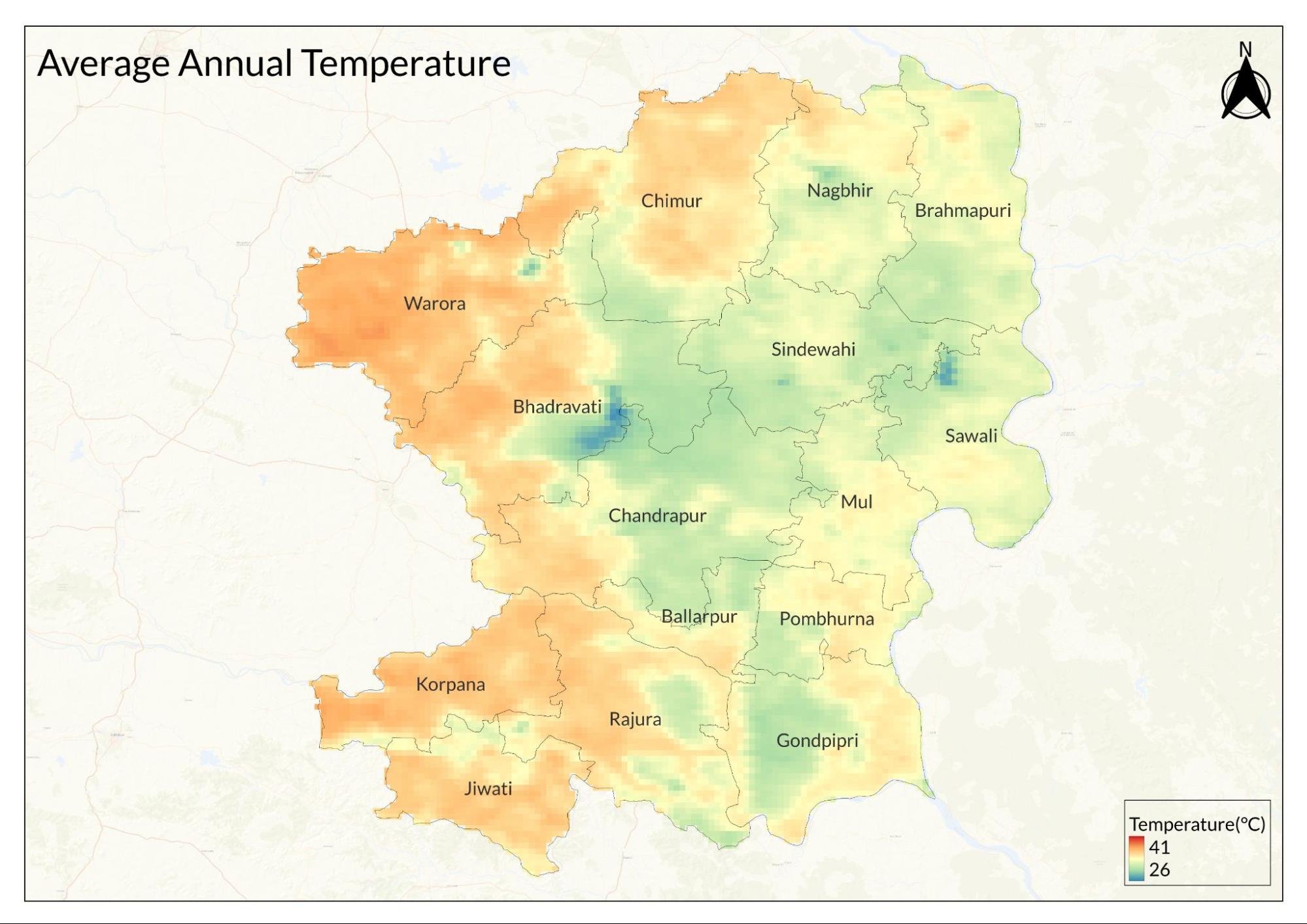
The district experiences hot and dry weather for most of the year, with average temperatures ranging from 23°C to 35°C. The climate is characterized by a hot summer season from March to May, with the highest temperatures reaching nearly 45°C, primarily in May. Winter spans from December to February, with December experiencing the coldest temperatures, around 16°C. This month is also the driest, receiving only 5.62 mm (0.22 in) of rainfall.

The southwest monsoon season occurs from June to September, with July being the wettest month, receiving approximately 476.15 mm (18.75 in) of rain. October and November constitute the post-monsoon season. Recently, the monsoon pattern has changed, and Chandrapur now averages 114 rainy days annually, in contrast to the 63 rainy days reported in the revised Gazetteer of 1972. The highest temperature ever recorded was 47.8°C in May 2018, while the lowest recorded temperature was 2.8°C in January 1899.
Geology
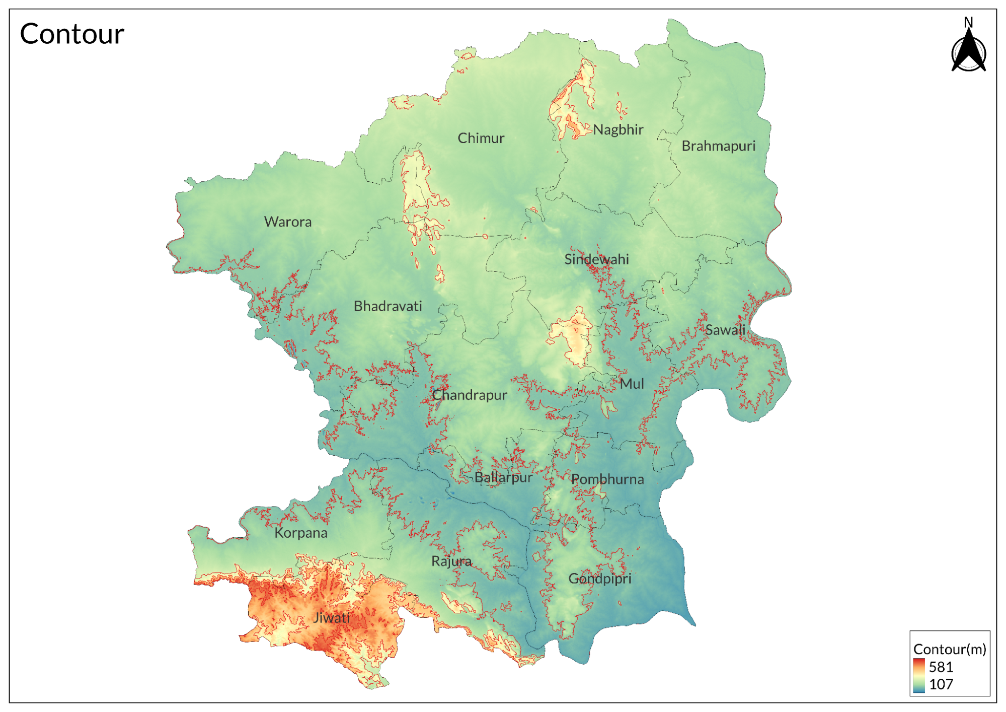
Geologically, the district features a mix of rocks dating back approximately 4 billion years (Archaean basement complex) to more recent times (Tertiary alluvium). Some areas of the district are located in the Penganga-Wardha rift, a recent geological event that has significantly shaped the landscape and history of the region.
Soil
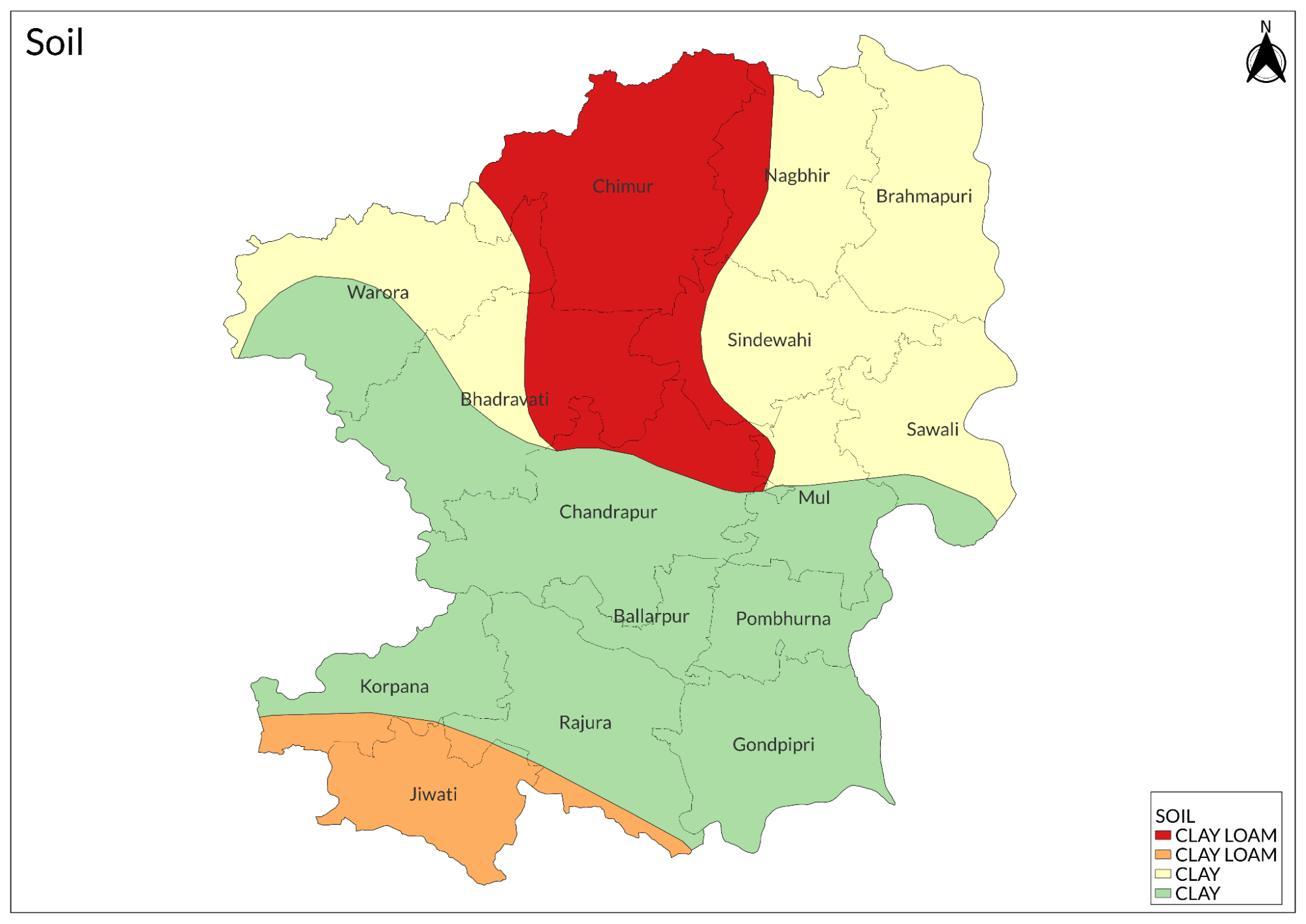
The bedrocks in several areas, especially along the river valleys of the region, are covered by recent alluvium deposited by streams, as well as different types of soils derived from the weathering of the underlying rocks. Soils such as black cotton ("Regur") from Deccan Trap rocks, which are rich in alumina, calcium, and magnesium carbonate, are commonly used in agricultural practices. Red soil, derived from weathered gneisses and older rocks, is also common in this region but is known to be less fertile.
Minerals
The main minerals found in the district include coal, iron ore, and limestone. Coal is abundant in areas such as Ghuggus, Ballarpur, Rajura, Manjri, and Warora, particularly in the Wardha River basin. Iron ore deposits are located in Pimpalgaon, Bhisi, Asola (Gunjevahi), Ratnapur, and Lohar Dongri. Limestone is plentiful in Warora and extends across Rajura. The district also has significant deposits of dolomite, quartz, fluorite, shale, sand, laterite, as well as some granite and sandstone. Overall, Chandrapur is a hub of diverse mineral resources essential for various industrial and construction purposes.
Rivers
Chandrapur District features two main rivers the Wainganga and Wardha, separated by a ridge formed by the Chimur and Mul hills. These valleys are situated at an average elevation of 600 to 800 feet above mean sea level and are dotted with smaller hills. The Chimur range begins near Chimur in the northern Warora tahsil and extends south for about 20 miles. Tadoba Lake, a famous scenic spot, is a prominent feature of the Chimur range. Further south, the Mul range, named after a nearby village, stretches 18 miles from north to south and 13 miles from east to west. Other hills in the district include the Seven Sisters hills, Manikgarh hill, Rajori Navergao hill, and Parasgad-Nagbhir hill.

The Wardha valley, reminiscent of the landscape seen from Bhusawal to Nagpur by train, is mostly barren land, except for occasional patches of jungle. In contrast, the Wainganga valley is more appealing, featuring stretches of jungle between villages and majestic trees such as mahua, tamarind, pipal, and mango. The hilly areas are enriched by beautiful locations like Tadoba Sanctuary and Tadoba Lake.
The western border of the district is uninterruptedly bounded by the Wardha, Pranhita, and Godavari rivers, while the Indravati runs for a considerable distance along the southeast corner of the district. More strikingly, the bold north-south line of the Wainganga enters the district near the center of its northern boundary and divides it into two unequal halves: the western half contains the Warora, Chandrapur, and Bramhapuri tehsils, while the eastern half comprises Gadchiroli district.
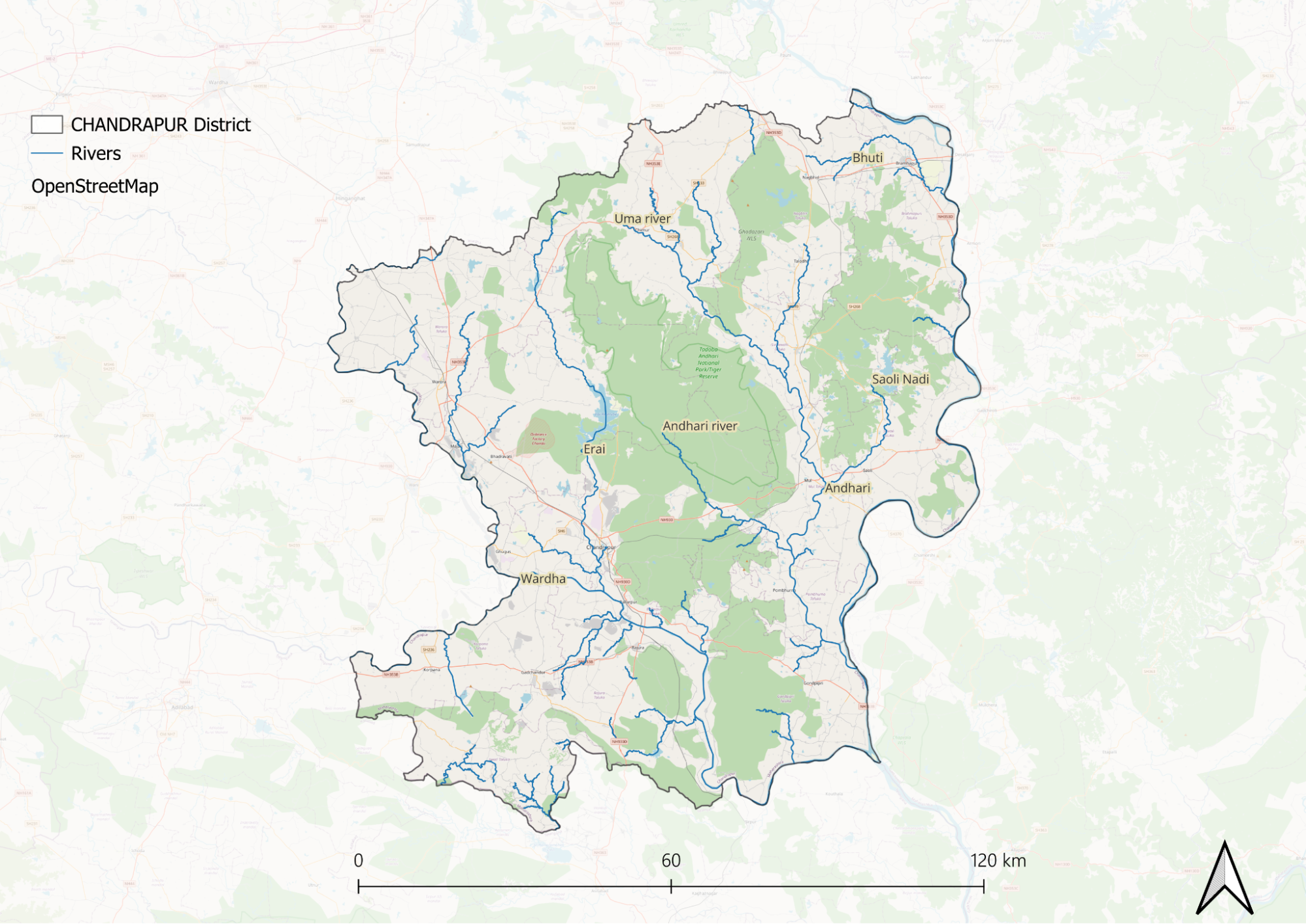
The Wardha is a sluggish stream that flows in a southeasterly direction through fertile land where the soil is predominantly black cotton. Along its course in the district, it converges with both the Penganga and Erai rivers from either side. The Erai rises in the northern Warora tehsil and flows for 50 miles until it joins the Wardha. The Erai Dam is constructed on this river, providing water to Chandrapur city and the Chandrapur Super Thermal Power Station. The Zarpat River is a tributary of the Erai and meets it near Mana village.
As it flows southward, the Wardha forms a confluence with the Wainganga, which then continues southward as the Pranhita River. The Wainganga receives numerous tributaries on either bank, with prominent ones being the Andhari and Mul rivers. The Wainganga is slightly more rapid than the Wardha; therefore, navigation is not common except in small areas like Pauni and Armori, especially during the rainy season.
All tributaries of the Wardha and Wainganga are primarily rain-fed and often reduced to mere chains of pools during the dry season. However, both main rivers are connected by a well-developed network of small streams and nullahs that ensures an unfailing water supply even in severe drought conditions. The Indravati River originates in the eastern Ghats' Tohamal highlands and enters Aheri village in Gadchiroli district, flowing for nearly 275 miles before finally joining the Godavari.
Despite state government efforts to prevent river pollution, a significant portion of effluent is discharged into both the Erai and Zarpat due to a severe lack of sewage treatment plants.
Botany
The riverbeds of the Wardha are prominent for shrubs such as rawan bel, taniki, and khatwat. Other common shrubs include jhau, gooseberry, machim, kharasni, adura, ghogurli, lokhandi, and burangi, which are found throughout the district. While chhota ber thrives in cultivated fields, timber trees like bijasal, shisham, haldu, anjan, dhaura, satinwood, lendia, and khair significantly contribute to the local economy by providing materials for construction, tools, and medicinal uses.
Fruit trees such as mango, tamarind, jamun, kawith, bel, and soanjua are valued for their fruits, which play essential roles in local diets and traditional medicine. Additionally, common creepers like kukudranj, yerun, belia palas, and loranthus longiflorus contribute to the area's biodiversity; however, some, like Loranthus longiflorus, pose challenges as parasites that damage local trees.
Among the wide variety of weeds and grasses in the district, one notable plant is bhenda, which has fibers similar to jute and has potential economic value. Many plants found here are often used by villagers for medicinal purposes, such as decoctions, hair washes, and pain relief. Prominent among these medicinal plants are mundi, dudhai, nagarmotha, gokarni, kacheri, dub grass, achyranthus aspera, chaolai, wagnakhi, dhatura, and ghol.
Wild Animals
The district has long been known for its wildlife, offering a haven for hunters seeking various large animals to pursue. While elephants are now extinct, they once roamed the Chandrapur area, as mentioned in the British Gazetteer of 1909. Tigers are widespread, particularly in the Moharli, Dabha, Ghot, and Ahiri forests, while panthers, known as “tendua,” are also common and tend to be more aggressive than tigers when they resort to cattle-lifting or man-eating. Leopards are frequently found in the region as they prey on smaller animals like deer and dogs.
The district is also home to jackals, foxes, honey badgers, black bears, Indian boars, and smaller cats like jangli billi, along with mongooses, wild dogs, and langurs. Several species of deer and antelope are abundant in the district. Sambar and chital are found in large numbers throughout the area. The blackbuck thrives in open regions, with horns averaging 20 inches. The four-horned antelope and chinkara are widely distributed and relatively common, while the nilgai prefers semi-open forests and often frequents abandoned village sites.
Birds
The peacock is the most noticeable and fairly abundant bird in the forest areas. Grey jungle fowl and jungli murgi are common in the bamboo forests. Spurfowl, grey and painted partridges, teetar birds, and a large variety of quails are also commonly found in this region. The population of aquatic birds is limited due to the small water bodies in the area. Whistling teals and common teals are typically found in summer, while a variety of duck species can be seen in the tanks during winter. Green pigeons and hariyal are found in large flocks throughout the district during the cold season.
Forest Reserves
Tadoba Andhari Tiger Reserve
Established in 1955, it is Maharashtra's oldest and largest national park, covering an area of approximately 1,727 square kilometers, which includes 577.96 Sq. km of reserved forest and 32.51 Sq. km of protected forest. The reserve features predominantly southern tropical dry deciduous forests, with teak as the primary tree species. It serves as a vital habitat for a variety of wildlife, including tigers, Indian leopards, sloth bears, and various deer species. The reserve is divided into three safari zones, Moharli, Tadoba, and Kolsa, with Moharli being particularly popular for tiger sightings.
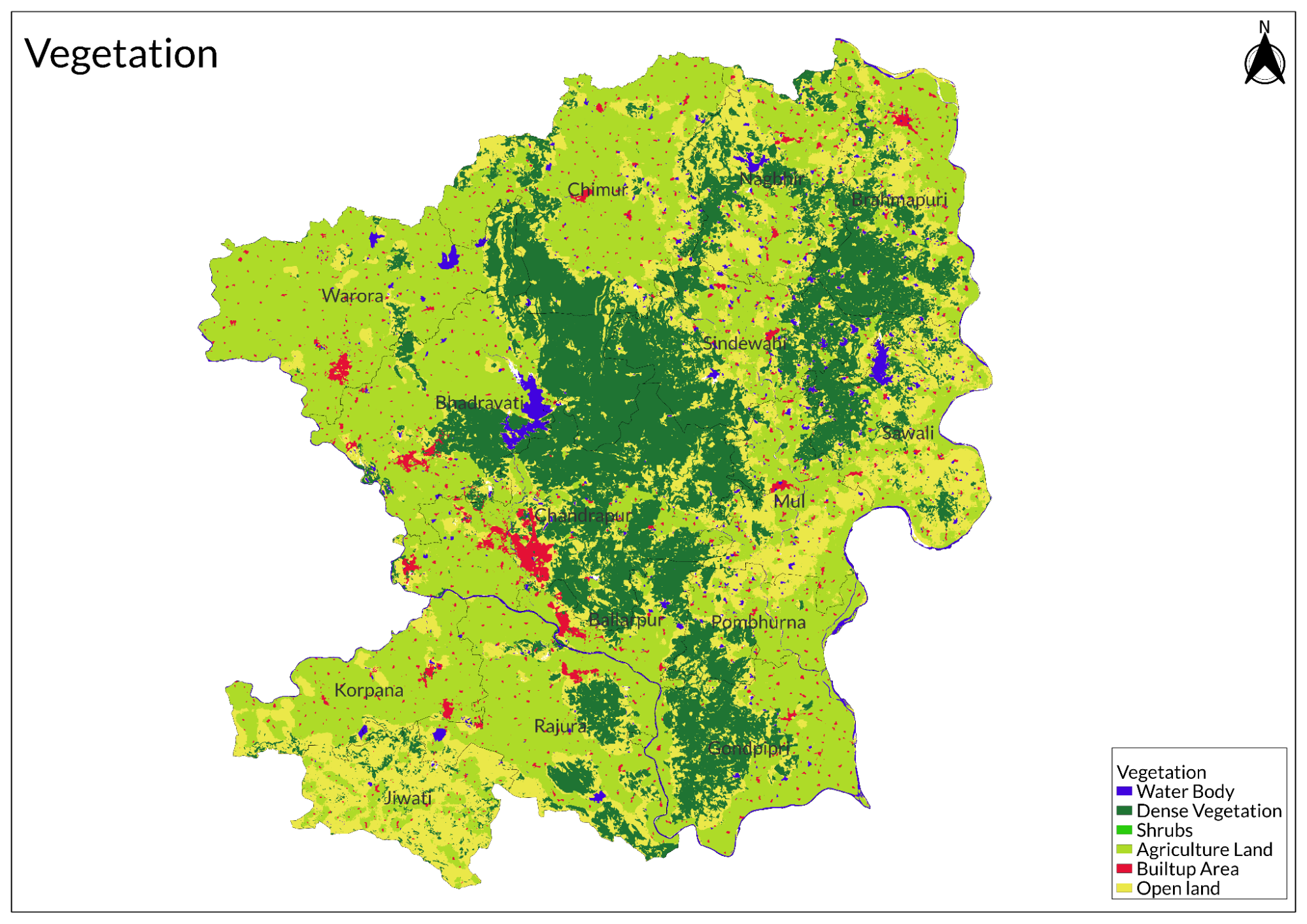
Land Use
Environmental concerns
Air Pollution
Chandrapur district, one of India’s most polluted areas, suffers from severe air quality issues, one primary reason being the Chandrapur Super Thermal Power Station (CSTPS), a 2,920 MW coal-fired plant that has emitted toxic pollutants for nearly four decades. In early 2022, sulfur dioxide (SO2) levels around CSTPS were recorded at eight times the permissible limit, with the Air Quality Index (AQI) reaching a hazardous 400. The plant generates vast amounts of fly ash and bottom ash, exacerbating environmental degradation, and in 2019, Chandrapur's Comprehensive Environmental Pollution Index (CEPI) stood at a critical 76.41. Activists highlight concerns over slurry leaks and unregulated waste disposal harming local water bodies and farmland. Despite mounting complaints and documented violations, regulatory actions remain minimal, with the Maharashtra Pollution Control Board failing to enforce significant penalties or operational reforms.
Deforestation
According to data from Global Forest Watch, the district has experienced significant deforestation in recent years, driven by forest land conversion for mining and thermal power plants, leading to severe habitat destruction that threatens local wildlife and disrupts forest-dependent communities. Efforts to combat deforestation face challenges such as regulatory loopholes and weak enforcement of environmental protections, though local advocacy groups continue pushing for sustainable land-use practices and reforestation initiatives to restore degraded areas and safeguard remaining forests.
Water Scarcity and Pollution
Chandrapur district faces severe water pollution, particularly groundwater contamination, with nearly 60% of tested samples exceeding safe nitrate limits, according to the Groundwater Survey and Development Agency (GSDA). While natural nitrate levels should range between 10-20 mg per liter, many samples in the district show concentrations between 200-300 mg per liter, with some reaching an alarming 1,218 mg per liter. This contamination stems largely from industrial activities, especially coal combustion, which releases nitrogen compounds that precipitate as acid rain, increasing nitrate levels in soil and groundwater. Additionally, excessive use of chemical fertilizers and pesticides in agriculture contributes to runoff pollution, while untreated human and animal waste further burdens water sources. The Central Groundwater Board reports that 48% of groundwater samples in Chandrapur show high nitrate contamination, alongside fluoride pollution in some talukas. The health risks are critical, particularly for infants, who face the danger of "Blue Baby Syndrome," which impairs oxygen transport in the blood. With public health at stake, urgent intervention from local authorities and environmental agencies is essential..
Climate Change Vulnerability
Chandrapur district, though not among Maharashtra’s most vulnerable regions, faces significant climate change challenges that threaten agriculture and livelihoods. A study by the Indian Council of Agricultural Research (ICAR) classifies Chandrapur as moderately vulnerable, along with 14 other districts, highlighting that 37% of Maharashtra's agricultural land faces moderate to high vulnerability due to extreme weather events, droughts, and declining water security. Changing rainfall patterns and rising temperatures endanger key crops like jowar, rice, wheat, and cotton, leading to reduced yields and food insecurity. The Central Vidarbha Zone, which includes Chandrapur, has 6.78% of its area highly vulnerable to climate impacts, underscoring the urgency for targeted interventions. Experts emphasize the need for robust climate action plans to address the district’s socio-economic vulnerabilities and enhance resilience.
Man-animal Conflicts
Chandrapur district is experiencing a growing crisis with human-tiger conflict, primarily driven by a growing tiger population (estimated at 248) and habitat encroachment due to industrial expansion and deforestation. In 2022 alone, 51 people lost their lives in wildlife attacks, mostly involving tigers, with many victims being farmers or forest produce collectors who unknowingly ventured too close to the animals. The fragmentation of wildlife corridors has forced tigers into agricultural lands and human settlements, where they prey on stray cattle, escalating tensions and leading to retaliatory actions from fearful villagers. While residents demand interventions such as capturing problem tigers or fencing villages, forest officials stress that long-term solutions require stakeholder cooperation and increased awareness to prevent encounters. The district’s rising tiger numbers highlight successful conservation efforts but also pose serious challenges for local communities.
Conservation Efforts
Ecopro Organisation
The Ecopro Organisation is situated near Ramala Talav, close to Ghate Hospital in Chandrapur. This NGO is committed to environmental conservation and sustainability initiatives. Their key activities include promoting awareness about environmental issues among local communities, implementing projects focused on waste management and pollution control, and engaging in tree plantation drives and other biodiversity conservation efforts. Ecopro Organisation aims to foster a culture of environmental responsibility among residents of Chandrapur, contributing significantly to the district's ecological health. Through their initiatives, they strive to create a cleaner and greener environment for future generations. These organizations collectively contribute to improving animal welfare and environmental conservation in Chandrapur, reflecting a strong commitment from both individuals and groups towards creating a more compassionate society.
Pyaar Foundation, Datala Road
The Pyaar Foundation, also known as the Petanity and Animal Rehabilitators Foundation, was established in 2018 with the mission to rescue and rehabilitate needy street animals, giving them a second chance at life. Located on Datala Road near Balaji Mandir in Chandrapur, the foundation aims to reduce human-animal conflict through awareness campaigns and various animal welfare initiatives.
Key activities of the Pyaar Foundation include rescue and rehabilitation efforts for injured animals, such as dogs and cats that have suffered from accidents or attacks. They also organize regular vaccination camps to promote the health of street animals and facilitate adoption programs to help rescued animals find loving homes. The foundation encourages community involvement through various volunteer roles, including fostering, social media management, and sterilization efforts. Their motto, "Pashu Rakhshanay Sadaiv Tatpar," reflects their commitment to animal welfare. Over the years, they have successfully transformed thousands of lives through their dedicated efforts.
S.P.C.A. (Society for the Prevention of Cruelty to Animals), Siddharth Nagar
The S.P.C.A., located on Colari Road in Siddharth Nagar, Chandrapur, is dedicated to preventing cruelty to animals and promoting their welfare. This organization focuses on various aspects of animal care, including providing shelter for abandoned and abused animals, offering medical treatment and rehabilitation services, and conducting awareness campaigns about animal rights and welfare.
The S.P.C.A. plays a crucial role in advocating for animal rights within the community and works closely with local authorities to address issues related to animal cruelty. Their efforts contribute significantly to raising awareness about the importance of treating animals with kindness and respect.
Graphs
Water
Climate & Atmosphere
Forests & Ecology
Human Footprint
Sources
Ali, M. 2012, December 10. Chandrapur faces threat of groundwater pollution. The Times of India.https://timesofindia.indiatimes.com/city/nag…
Behl, M. 2021, August 7. NGP among 9 dists least at risk of climate agri distress, 11 are highly vulnerable. The Times of India.https://timesofindia.indiatimes.com/city/nag…
Dhembla, M., & Knapp, C. (2023, February 28). Breathing the Toxic Air of Chandrapur. Pulitzer Center.https://pulitzercenter.org/stories/breathing…
Global Forest Watch. Chandrapur, Maharashtra, India Deforestation Rates & Statistics.https://gfw.global/3QOGqq8
Shende, R. R. 2013.Ground Water Information Chandrapur District Maharashtra (1759/DBR/2013). Government of India, Ministry of Water Resources, Central Ground Water Board.https://www.cgwb.gov.in/old_website/District…
Last updated on 6 November 2025. Help us improve the information on this page by clicking on suggest edits or writing to us.