Contents
- Physical Features
- Climate
- Geology
- Soil
- Minerals
- Rivers
- Botany
- Wild Animals
- Birds
- Forest Reserves
- Yedshi Ramalinga Sanctuary
- Land Use
- Graphs
- Water
- A. Rainfall (Yearly)
- B. Rainfall (Monthly)
- C. No. of Rainy Days in the Year (Taluka-wise)
- D. Evapotranspiration Potential vs Actual Numbers (Yearly)
- E. Annual Runoff
- F. Runoff (Monthly)
- G. Water Deficit (Yearly)
- H. Water Deficit (Monthly)
- I. Seasonal Groundwater Levels: Bore Wells
- J. Seasonal Groundwater Levels: Dug Wells
- Climate & Atmosphere
- A. Maximum Temperature (Yearly)
- B. Maximum Temperature (Monthly)
- C. Minimum Temperature (Yearly)
- D. Minimum Temperature (Monthly)
- E. Wind Speed (Yearly)
- F. Wind Speed (Monthly)
- Forests & Ecology
- A. Forest Area
- B. Forest Area (Filter by Density)
- C. Wildlife Projects (Area and Expenses)
- Human Footprint
- A. Nighttime Lights
- Sources
DHARASHIV
Environment
Last updated on 6 November 2025. Help us improve the information on this page by clicking on suggest edits or writing to us.
Dharashiv (Osmanabad), located in the southernmost part of Maharashtra's Aurangabad Division, is a district of rich geographical diversity and historical significance. Positioned on the Balaghat plateau, the region features a rugged landscape shaped by basaltic lava flows, with elevations influencing its climate, water resources, and soil composition. Despite its largely dry climate, Dharashiv supports a diverse range of flora and fauna, with scattered forests and wildlife reserves. The district's rivers, though seasonal, play a crucial role in agriculture and local livelihoods. With a history deeply rooted in natural formations and evolving land use, Dharashiv's environment offers a compelling study of ecological resilience and adaptation.
Physical Features
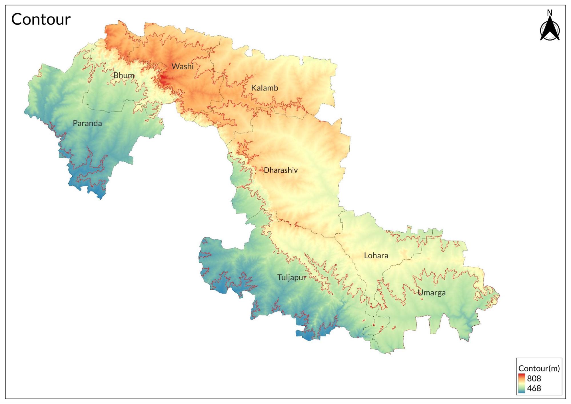
Dharashiv is the southernmost district in the Aurangabad Division of Maharashtra, India. According to the district gazetteer of 1972, Dharashiv District is primarily located on the Balaghat plateau, which generally rises above 610 meters (2,000 feet) above sea level. This plateau slopes toward the south and east, serving as a water divide between the Godavari and Bhima valleys. The northern edge of the plateau extends eastward across the middle of the Bhir district and enters Dharashiv near Degaon. It continues southward and eastward while gaining altitude before running southeast past Udgir and exiting the district. The southern edge of the plateau, supported by a series of hills, enters near Malewadi and Pakhrud villages and generally runs southeast, passing west of Yermala, Yedsi, Dharashiv, and Tuljapur before continuing outside the district. The dissected slopes of these scarps appear as a series of hills when viewed from the plains below. Over time, erosion from streams has caused these scarps to retreat, resulting in higher elevations often being found away from the steep faces.
Climate
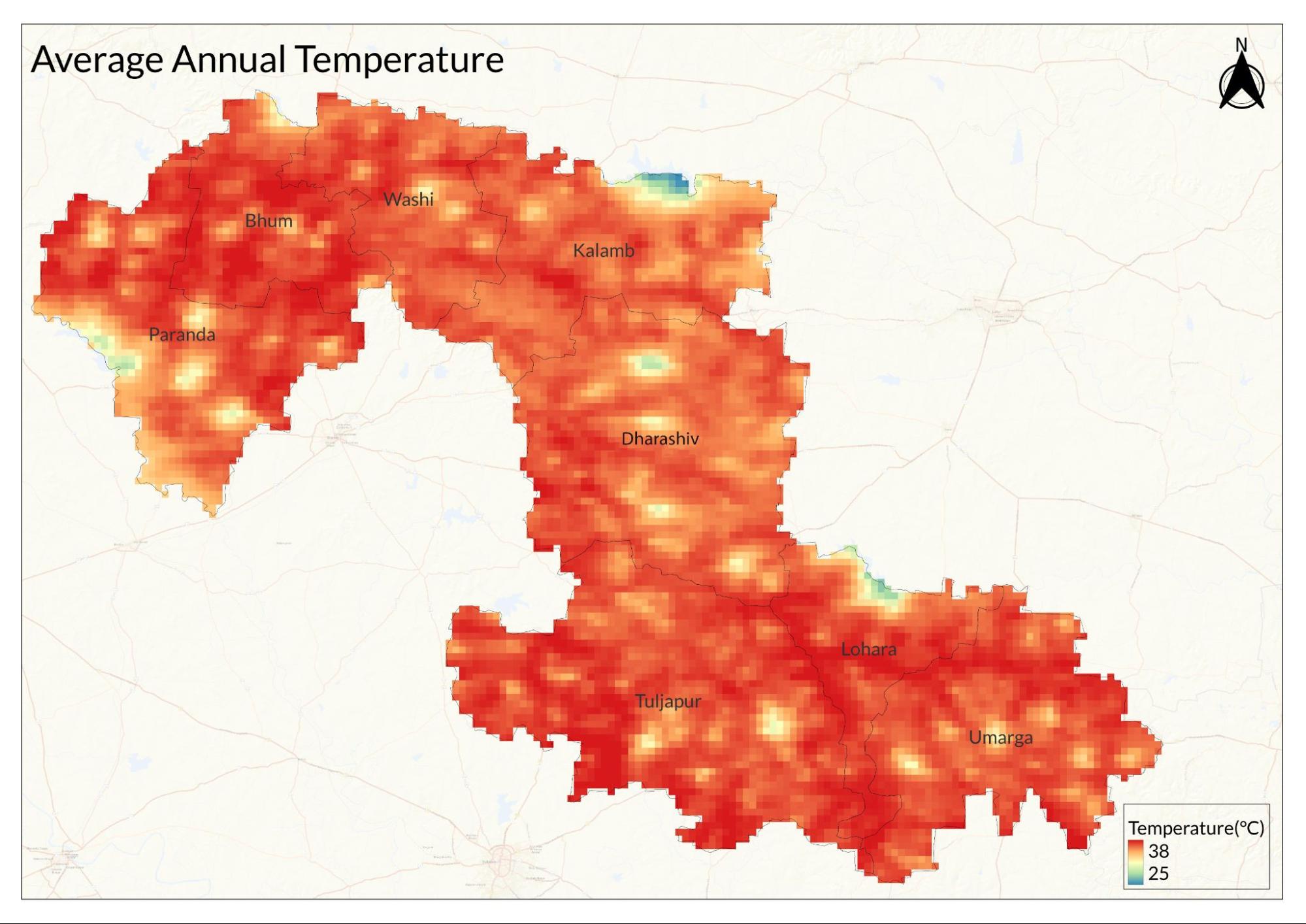
The climate of the district is generally dry, except during the monsoon season, and can be divided into four distinct seasons: the cold season from December to mid-February, summer from February to May, the southwest monsoon from June to September, and the post-monsoon period in October and November.
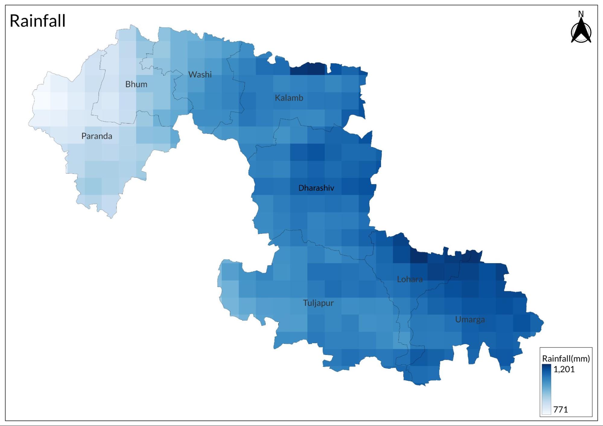
Rainfall varies significantly from year to year; for example, in the 60 years from 1901 to 1960, the highest annual rainfall was 168% of normal in 1916, while the lowest was 59% in 1918. On average, there are about 51 rainy days each year, with the heaviest recorded rainfall being 247.1 mm (9.73 inches) in a single day on September 7, 1895. Temperature records indicate that December is typically the coldest month, while May is usually the hottest, with temperatures sometimes reaching up to 45°C (113°F). Humidity levels are high during the monsoon but mostly dry throughout the rest of the year. Winds are generally light but increase during the summer and monsoon seasons. This climate overview is based on data provided by the Meteorological Department of the Government of India, Pune.
Geology
The district is primarily characterised by its geological formation known as the Deccan Traps, which consists of extensive basaltic lava flows that contribute to the region's plateau-like topography. These basalt layers, varying in thickness from a few meters to over 55 meters, are crucial for groundwater aquifers in the area. The soils in Dharashiv are mainly derived from this basalt and can be classified into shallow, medium, and medium-deep types, with dark brown to grey hues and varying textures.
Soil
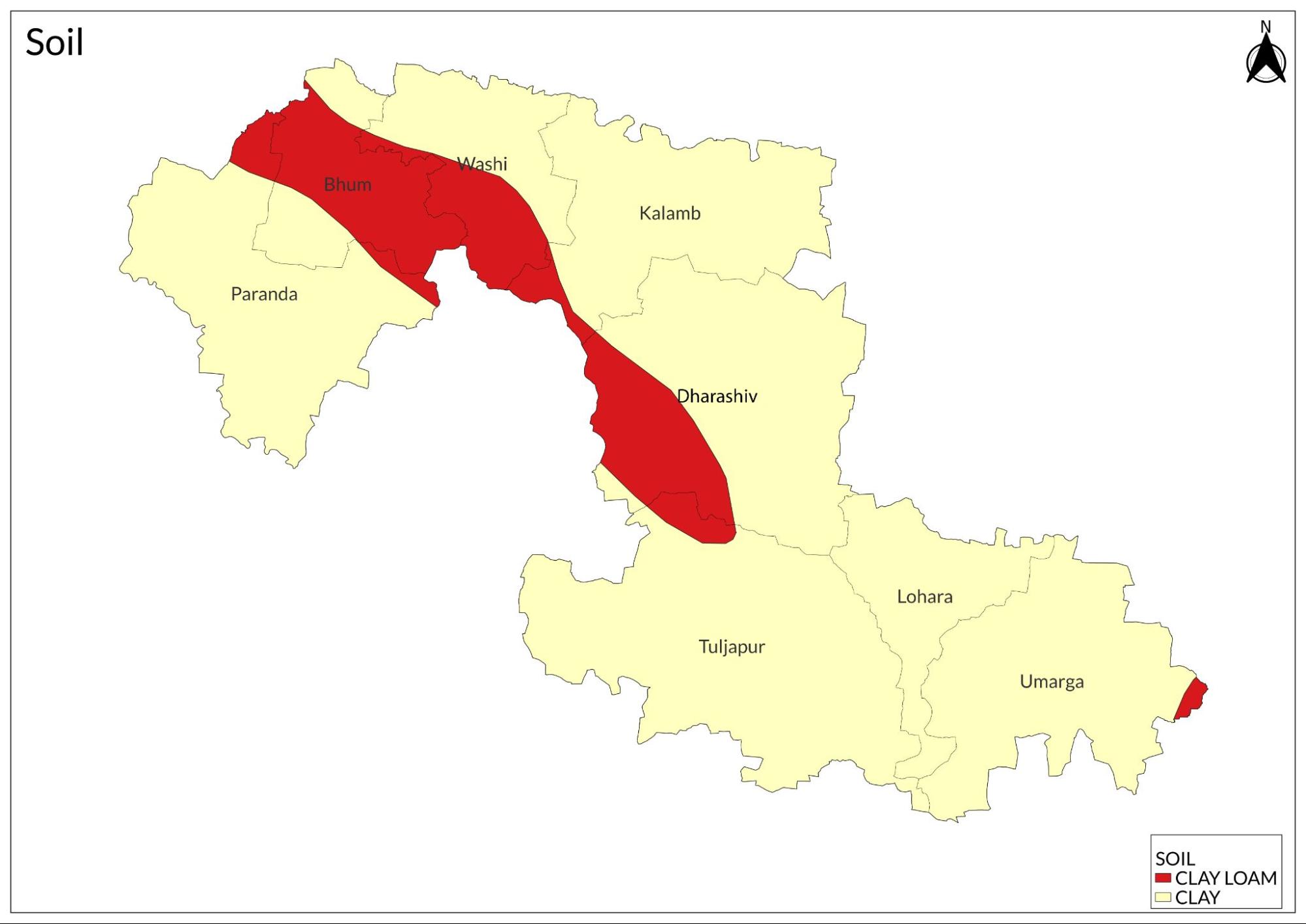
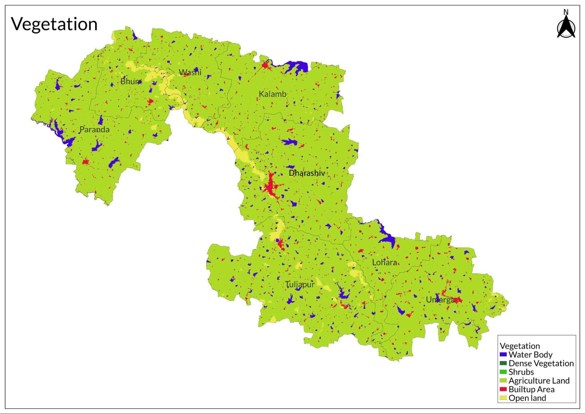
Shallow soils are found in small patches, particularly in the western and northwestern regions, exhibiting a light brown to dark grey colour with a loamy to clayey texture. Medium soils, prevalent in the Bhoom, Kallamb, and Dharashiv talukas, are darker, ranging from dark brown to dark grey. Medium deep soils, mainly located in the Tuljapur taluka, are typically dark grey-brown to very dark grey and have a clayey texture. These soils possess an average to high mineral content, essential for agricultural productivity, with key nutrients like nitrogen, phosphorus, and potassium varying across different areas. This soil quality significantly influences local agriculture, supporting the cultivation of crops such as sunflower, jowar (sorghum), and various pulses, which are vital for the region's economy.
Minerals
The most common is basalt, which is important for building and construction. The area also has iron ore, which is mined locally, and clay, used by manufacturers for different products. Silica sand is available too, mainly for making glass and in construction. While the groundwater in Dharashiv is generally good for drinking and farming, some areas face problems with fluoride contamination due to human activities.
Rivers
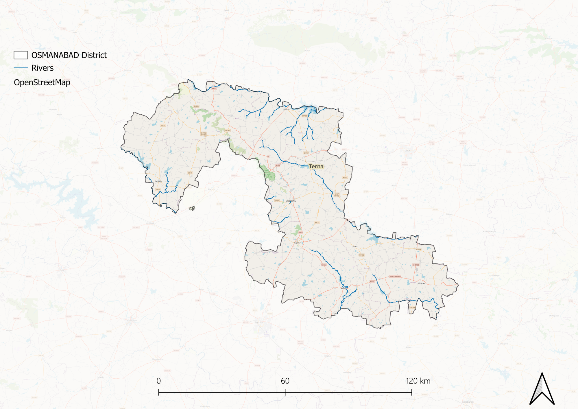
As no perennial river originates in Dharashiv (it’s a low waterfall area), the district is almost entirely dependent on its neighbouring districts for water. The ones that originate in the district all dry out quite soon. Water governance is a pertinent issue in the district. Accounts about Ter in the past show that there used to be some cultivation of cotton in the area, which means that historically, Dharashiv might have been more fertile than it currently is.
Moreover, Dharashiv District features a complex drainage system. The southern and western parts are drained by tributaries of the Bhima River, while the rest is primarily drained by the Manjra River and its tributaries, part of the Godavari system. The Manjra, along with the Terna, Tawarja, and Gharni rivers, drains the Balaghat Plateau, while the Manar, Tiru, and Lendi rivers drain the northern plateau region.
The Manar River rises near Dharmapuri and flows northeast for about 40 kilometres before entering the Nanded district. The Tiru River originates near Chakur and flows approximately 56 kilometres east to join the Lendi at Kharka in Nanded. The Lendi River, which also rises near Udgir, has a shorter course within Dharashiv before joining the Tiru.
The Manjra River rises near Gaurwadi and flows southeast into Dharashiv, forming part of the district boundary. After receiving water from the Rena River, it continues southward until it reaches Chichaundi and then forms part of the state boundary before turning east into Mysore State.
The Gharni River, a significant left bank tributary of the Manjra, is about 40 km long and flows southward past several villages before joining the Manjra near Jawalga. The Devan Nadi, a smaller left bank tributary, flows about 20 km within Dharashiv.
The main right bank tributaries include the Tawarja, which flows about 50 kilometres eastward to join the Manjra near Seoni village, and the Terna, which is over 150 km long with an earthen dam above Thail village.
Other rivers include the Benithora, a tributary of the Bhima that rises on Deobet hill's slopes; the Bori, which flows southeast to join the Bhima; and the Harni, an important tributary of the Bori. The Sina River runs along the western boundary as a major tributary of the Bhima.
Botany
The district has very limited forest resources, primarily located in the Tuljapur tahsil, which is divided into three management areas overseen by the round officers. The total forest area is only 15.411 km² (5.95 square miles), and the Divisional Forest Officer based in Ahmadnagar supervises these forests under the Conservator of Forests for the Pune Circle. The forests are mainly of thorny scrub type, featuring common species such as Khair, Hivar, Hankal, Apta, and Neem. There are also grassy areas with important grass species like Kusal, Sheda, and Marvel. Most of the forest produce is consumed locally. To address deforestation, the Forest Department has initiated a large-scale afforestation program and established a nursery at Wadgaon, successfully afforesting 607.029 hectares (1,500 acres) with various tree species, primarily Neem, Shisam, and Shiras. Key species in the forests include Dhavada, Salai, Bor, and several others.
Wild Animals
The Leopard is occasionally sighted, particularly in the reserved forest areas of Tuljapur tahsil. Various deer species inhabit the region, including Spotted Deer, Antelope, Four-Horned Deer, and Barking Deer, which are commonly seen in grassy wastelands near agricultural lands. The Wild Boar is prevalent throughout the district, often taking shelter in forests or wastelands adjacent to cultivation, and can be found either alone or in groups.
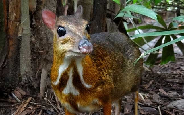
Common wildlife includes Grey Monkeys, Jackals, Foxes, and Mongooses, all of which are widespread throughout the area. Additionally, hyenas are occasionally reported.
Birds
Ducks and teals are usually found near rivers, ponds, or artificial reservoirs. Rarely seen in winter are the Jack and Painted Snipe, along with the Stone Plover, which appears in very small numbers. Game birds like the Painted Partridge and Grey Partridge are common in grassy areas during the cold season, while Rain Quails and Grey Quails are often spotted near farms. The Peafowl is mostly found in wooded and grassy regions of Tuljapur Tahsil, and Green Pigeons gather on fruit trees during winter. The Common Grey Hornbill is seen from August to November near villages, especially on banyan and pipal trees, while the Tree Pie is rarely present. Bayas can sometimes be spotted near water, where they build hanging nests. Other common birds include the White-breasted Kingfisher, Blossom-headed Parakeet, Red-vented Bulbul, Green Bee-eater, Black Drongo, Spotted Owlet, Indian Magpie Robin, Jungle Crow, and House Crow. Finally, the Koel visits only in spring.
Forest Reserves
Yedshi Ramalinga Sanctuary
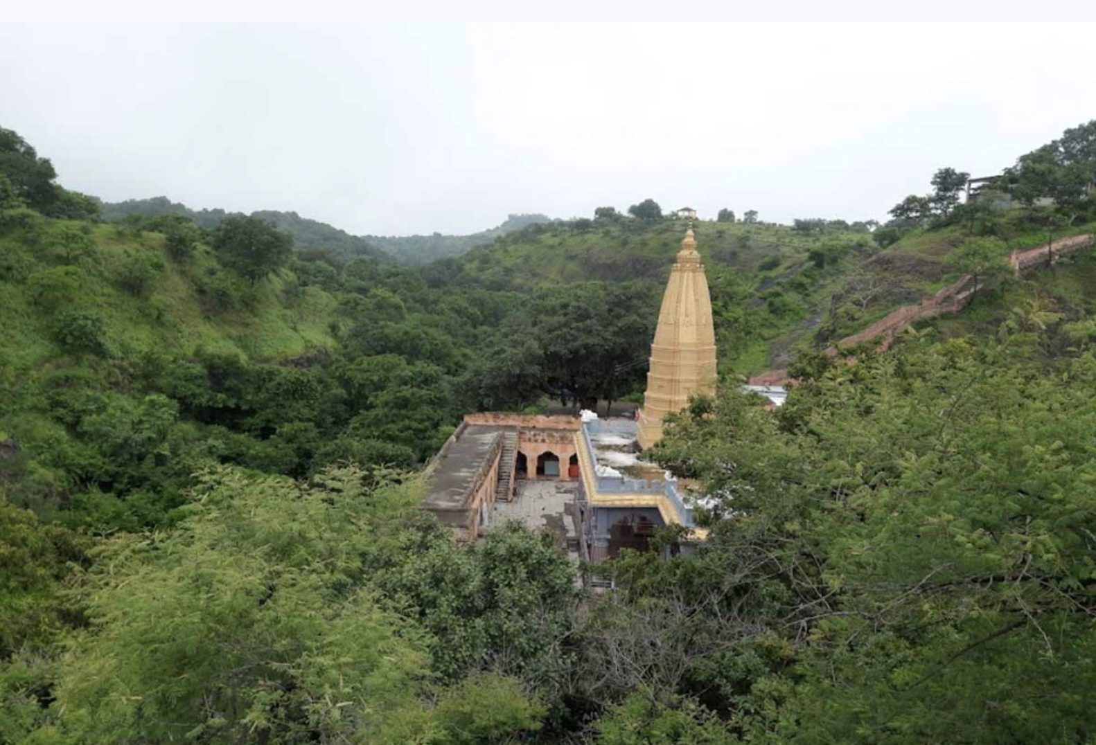
Established in 1997, it spans 2,237.5 hectares and serves to protect a diverse range of flora and fauna, making it a significant site for biodiversity conservation. The sanctuary is situated along the Latur-Barshi highway, which facilitates access and helps in the protection of local wildlife. It is also recognised as a hill station due to its elevation above sea level.
The area is characterised by sparse tree distribution and features several plant species, including Dhawda, Sitaphal, Apta, Babuldhaman, Khair, Hiwar, and Bor. Additionally, shrubs like Lantana and Karwand can be found here, along with grasses such as Kusali, Mavvel, and Shedya. The nearby Yedshi reserve forest supports tree species like Dikamals, Sandalwood, Bel, Teak, and Arjun.
The sanctuary is home to over 100 bird species, including many peacocks. Other wildlife includes wild boars, chinkaras, foxes, wolves, hares, and hyenas. This rich biodiversity is complemented by various ecosystems such as subtropical dry deciduous forests and thorn forests.
Yedshi Ramling Ghat Wildlife Sanctuary attracts numerous visitors for its natural beauty and wildlife. The best time to visit is from October to June, making it an ideal destination for nature enthusiasts seeking recreational opportunities while enjoying the splendour of the great outdoors.
Land Use
Graphs
Water
Climate & Atmosphere
Forests & Ecology
Human Footprint
Sources
Osmanabad District Gazetteer (Reprint 2006). 1972. Government of Maharashtra.https://gazetteers.maharashtra.gov.in/cultur…
Last updated on 6 November 2025. Help us improve the information on this page by clicking on suggest edits or writing to us.