Contents
- Physical Features
- Climate
- Geology
- Soil
- Minerals
- Rivers
- Botany
- Wild Animals
- Birds
- Land Use
- Environmental Concerns
- Deforestation
- Water Scarcity
- Conservation Efforts/Protests[4]
- Graphs
- Water
- A. Rainfall (Yearly)
- B. Rainfall (Monthly)
- C. No. of Rainy Days in the Year (Taluka-wise)
- D. Evapotranspiration Potential vs Actual Numbers (Yearly)
- E. Annual Runoff
- F. Runoff (Monthly)
- G. Water Deficit (Yearly)
- H. Water Deficit (Monthly)
- I. Soil Moisture (Yearly)
- J. Seasonal Groundwater Levels: Bore Wells
- K. Seasonal Groundwater Levels: Dug Wells
- Climate & Atmosphere
- A. Maximum Temperature (Yearly)
- B. Maximum Temperature (Monthly)
- C. Minimum Temperature (Yearly)
- D. Minimum Temperature (Monthly)
- E. Wind Speed (Yearly)
- F. Wind Speed (Monthly)
- G. Relative Humidity
- Forests & Ecology
- A. Forest Area (Filter by Density)
- B. Wildlife Projects (Area and Expenses)
- Human Footprint
- A. Nighttime Lights
- Sources
HINGOLI
Environment
Last updated on 6 November 2025. Help us improve the information on this page by clicking on suggest edits or writing to us.
ENVIRONMENT: HINGOLI
Hingoli district, situated in the Marathwada region of Maharashtra, is a land of diverse landscapes, rich geological formations, and vital river systems that shape its ecological and economic framework. Resting on the Deccan Plateau, its undulating terrain, black cotton soil, and semi-arid climate play a crucial role in defining agricultural practices and water management strategies. The district is home to rivers like the Purna, Kayadhu, and Penganga, which sustain local communities and contribute to irrigation. Its mineral resources, including basalt and zeolites, support small-scale industries, while the region’s dry deciduous forests host a variety of flora adapted to its climate. Hingoli’s natural features have influenced human settlement patterns, land use, and conservation efforts, making it a distinctive part of Maharashtra’s geographical and cultural landscape.
Physical Features
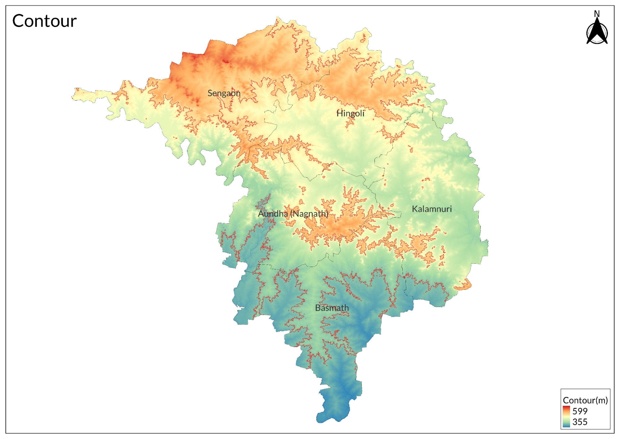
Hingoli district lies in the Marathwada region of Maharashtra, positioned on the Deccan Plateau. The district's terrain is characterized by undulating landscapes with elevations ranging from 450 to 500 meters above sea level. The land slopes gradually from north to south, creating distinct physiographic zones across the district.
The northern region features higher elevations and pronounced relief patterns, transitioning into extensive plains in the central areas. The southeastern portion contains gentle terrain with broad valleys and floodplains, particularly along river courses. Scattered hills, typical of the Deccan trap formation, rise above the general terrain throughout the district.
The topography has created multiple small watersheds and seasonal water collection points in natural depressions. These features significantly influence local drainage patterns and groundwater recharge. The terrain's natural gradient directs water flow predominantly southward, following the general slope of the land.
The physical landscape has shaped the district's land use patterns, with agricultural activities concentrated in the gentler slopes and plains. The more elevated areas retain patches of natural vegetation, while the broader valleys support intensive farming. This topographical arrangement has also influenced the distribution of settlements and infrastructure across the district.
The district's elevation and terrain characteristics make it susceptible to soil erosion during heavy rains, particularly in areas with steeper slopes. Conservation measures, including contour bunding and terracing, are commonly employed to protect agricultural lands and maintain soil fertility.
Climate
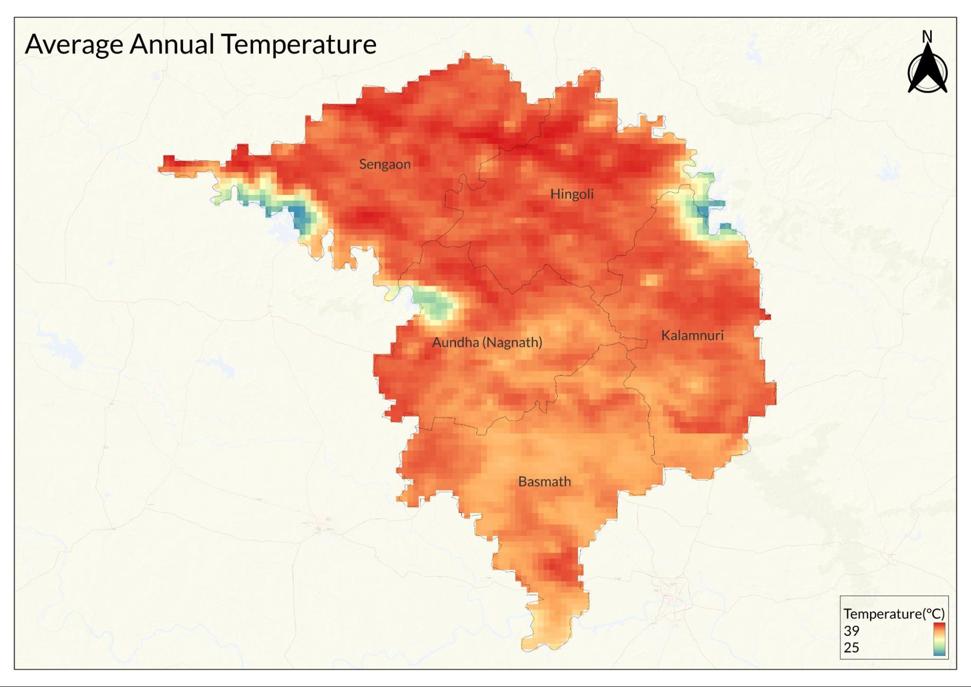
Hingoli experiences a semi-arid climate with three distinct seasons: summer, monsoon, and winter. The annual temperature ranges from 12°C to 43°C, with an average annual rainfall of 700-800mm.
Summer (March to June) is characterized by intense heat and dry conditions. Maximum temperatures regularly reach 42-43°C in May, the hottest month. Hot winds (loo) are common during this period, and humidity levels remain low. Day temperatures often exceed 40°C, while nights are relatively cooler at 25-28°C.
The monsoon season (June to September) brings moderate rainfall, though its distribution is often irregular. July and August receive the maximum precipitation. The district frequently experiences dry spells between rain episodes, affecting agricultural activities. The average number of rainy days ranges from 45 to 50 per year. Winter (November to February) is mild and pleasant. Minimum temperatures drop to 12-15°C in December and January, while maximum temperatures hover around 28-30°C. Morning fog is common during this season, particularly in low-lying areas. Cold waves occasionally affect the region during December-January. The transitional months of October and March experience moderate temperatures. The climate significantly influences agricultural patterns, with most farming activities aligned with monsoon arrival. The region is prone to occasional droughts due to monsoon variability, impacting both agriculture and water resources.
Geology
Hingoli district is predominantly composed of Deccan trap basalts, formed during the Cretaceous-Eocene period through extensive volcanic activity. These basalt formations appear in distinct horizontal layers, representing multiple phases of lava flows that occurred approximately 65-66 million years ago. The thickness of individual basalt flows varies from a few meters to several tens of meters.
The basaltic rock structure exhibits characteristic features including vesicular tops, jointing patterns, and weathered zones. The vesicular basalt contains numerous small cavities formed by trapped gases during lava cooling, while the massive basalt layers are more compact and less weathered. These variations influence local groundwater movement and storage patterns.
The geological formation includes intertrappean beds between different lava flows, containing sedimentary deposits laid down during periods between successive volcanic eruptions. These beds often contain minerals like zeolites and calcites in the vesicular cavities. The weathering of basalt has led to the formation of characteristic black cotton soil across much of the district. The area shows evidence of minor faulting and joints in the basaltic terrain, which influence local drainage patterns and groundwater movement. These geological structures create natural pathways for water percolation and storage, forming the district's aquifer system. The rock formations are generally horizontally bedded with a slight regional dip towards the southeast. The basement rocks beneath the Deccan traps remain largely unexplored due to the thick cover of basaltic flows.
Soil

The predominant soil type in Hingoli is black cotton soil (regur), derived from the weathering of Deccan trap basalts. This soil has high clay content, particularly montmorillonite clay minerals, which give it distinctive swelling and shrinking properties. The soil depth varies considerably across the district, ranging from medium to deep profiles that can extend from 30 centimeters to several meters below the surface. These soils exhibit strong water retention capacity but also form deep cracks during dry periods, presenting unique challenges for agriculture and construction.
The chemical composition of Hingoli's soil is characterized by its alkaline nature, with pH levels typically ranging from 7.5 to 8.5. The soil is rich in essential minerals, including calcium carbonate, magnesium, potassium, and iron. However, it generally shows a deficiency in nitrogen and phosphorus, requiring specific fertilization strategies for optimal agricultural production. The high calcium carbonate content contributes to the soil's alkaline nature and influences nutrient availability to plants.
Secondary soil types are found in specific areas of the district, creating a diverse soil landscape. Red soils occur in elevated regions, while mixed red and black soils are present in transitional zones. Along river banks, sandy loam soils predominate, and the river valleys contain fertile alluvial deposits. These variations in soil type create distinct agricultural zones within the district, each requiring specific farming approaches.
The soil characteristics significantly influence agricultural practices in Hingoli. The black cotton soil is particularly well-suited for growing cotton, soybean, and pulses, but requires careful moisture management and specific timing of tillage operations. The soil's high clay content presents challenges for root crops and necessitates proper drainage systems in agricultural fields. Regular addition of organic matter is essential to improve soil structure and fertility, particularly in areas where intensive farming is practiced.
Minerals
Hingoli's mineral resources are primarily associated with its Deccan basalt geological formation, offering limited but locally significant mineral deposits. Building materials constitute the most economically important mineral resources in the district. Basalt, extracted from numerous quarries, serves as the primary construction stone and is widely used for building foundations, road metal, and aggregate production.

These minerals, though not extensively mined, have potential applications in water filtration and agricultural soil improvement. Iron-rich minerals occur as secondary deposits within weathered basalt zones, though not in commercially viable concentrations.
Construction minerals form a significant part of the district's mineral resources. River sand deposits, found along major waterways like the Purna River, are extracted for construction purposes. Brick earth, derived from weathered basalt and alluvial deposits, supports local brick-making industries. Murrum, a weathered rock material, is extensively used for road construction and land filling.
Minor mineral occurrences include calcite crystals in basalt cavities, kankar (nodular limestone) in soil layers, and occasional quartz veins. These minerals, while present, are not extracted on a commercial scale. The district also contains deposits of gravel and stone ballast, which are primarily used in local construction activities and infrastructure development.
The exploitation of these mineral resources is regulated through quarry licenses and mining permits, with emphasis on sustainable extraction practices and environmental protection. Most mining activities are small-scale and cater to local construction needs rather than industrial-scale mineral production.
Rivers
The Purna River is the major watercourse flowing through the Hingoli district, traversing the northern regions from west to east. This perennial river, originating in the Ajanta hills of Aurangabad district, serves as a crucial water source for irrigation and domestic use. Its flow varies seasonally, with maximum discharge during monsoons and reduced flow in summer months. The river has created extensive floodplains that support agricultural activities along its course.
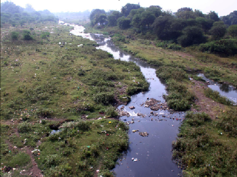
The Penganga River forms part of the district boundary in the southeastern region. Though seasonal, this river contributes significantly to the groundwater recharge in its basin area. Its catchment area supports numerous agricultural activities and provides water for local communities during non-monsoon periods.
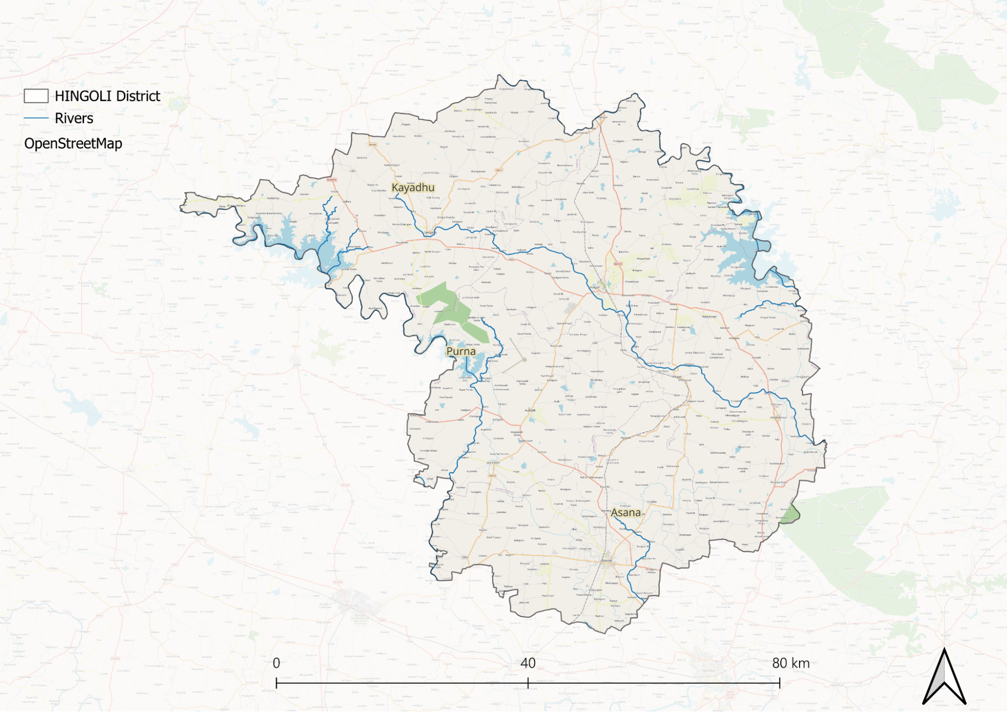
Several seasonal streams and minor tributaries crisscross the district, forming a dendritic drainage pattern typical of the Deccan trap region. These include the Kapra, Pus, and Kundi streams, which flow primarily during the monsoon season. These waterways, though seasonal, are crucial for groundwater recharge and local irrigation needs.
The river systems in Hingoli face challenges including seasonal flow variations, siltation, and water quality issues. Water conservation efforts, including watershed development programs and river restoration projects, are being implemented to ensure sustainable water availability throughout the year.
The rivers also support small-scale fishing activities and play a crucial role in maintaining local biodiversity.
Botany
The vegetation of Hingoli predominantly consists of tropical dry deciduous forests, reflecting the region's semi-arid climate conditions. Teak serves as a dominant species, particularly in the remaining forest patches. The native flora has adapted to the black cotton soil and seasonal rainfall patterns, with many species exhibiting drought-resistant characteristics.
Common tree species include Babul, Neem, Mahua, and Peepal. These species form the backbone of the district's natural vegetation and are particularly prevalent in rural areas and along roadsides. The Gulmohar and Subabul are widespread in urban areas and planned plantations.
Medicinal plants form an important component of the local flora, with species like Adulsa, Bhringraj, and Nirgudi growing naturally throughout the district. These plants have traditional importance in local healthcare practices. The region also supports various species of grasses, particularly during the monsoon season, including Marvel grass and Kunda grass. Shrub vegetation is characterized by species adapted to the local climate, including Lantana, Karonda, and various thorny bushes. The agricultural landscape supports numerous wild species along field boundaries and fallow lands. Seasonal herbs and climbers appear abundantly during the monsoon season, adding to the region's biodiversity.
The district's botanical resources face pressure from urbanization, agricultural expansion, and grazing. Conservation efforts focus on protecting native species through social forestry programs and urban greening initiatives.
Wild Animals
The Indian Grey Wolf and Golden Jackal represent the larger carnivores in the Hingoli district, primarily inhabiting the scrubland areas and forest patches. The Indian Fox is commonly found in the grasslands and agricultural peripheries, while Striped Hyenas occasionally visit from neighboring regions, particularly in areas with good cover.
The district supports a population of Indian Gazelle or Chinkara and Blackbuck, though their numbers have declined due to habitat fragmentation. Wild boars are commonly found throughout the district, often venturing into agricultural fields. The Indian Grey Mongoose and Small Indian Civet are frequent visitors to both rural and semi-urban areas.
Various species of bats, including the Indian Flying Fox, inhabit old structures and large trees. The reptilian fauna includes the Indian Monitor Lizard, Indian Cobra, Russell's Viper, and Common Krait. These species play crucial roles in maintaining the ecological balance, particularly in agricultural areas where they help control rodent populations.
Birds
The Indian Peafowl is commonly found in rural and forested areas, while the Grey Francolin and Indian Jungle Quail inhabit grasslands and agricultural fields. These ground-dwelling birds play essential roles in local ecosystems, controlling insect populations and dispersing seeds. Raptors are well-represented in the district, with Black Kite, Shikra, and White-eyed Buzzard being common. The Short-toed Snake Eagle specializes in hunting snakes in open areas. Egyptian Vultures, though declining, are occasionally spotted.
Water bodies, particularly around rivers and reservoirs, attract various wetland birds. These include Little Cormorant, Common Kingfisher, and White-breasted Waterhen. During winter, migratory waterfowl visit these water bodies, adding to the seasonal diversity. Common urban birds include House Sparrows, Common Mynas, and Rose-ringed Parakeets. The agricultural landscape supports Indian Roller, Green Bee-eater, and various species of larks and pipits. Baya Weavers are notable for their distinctive hanging nests in rural areas. The scrubland areas provide habitat for Yellow-wattled Lapwing, Indian Robin, and Common Babbler. These species have adapted well to the semi-arid conditions and play important roles in the local food web.
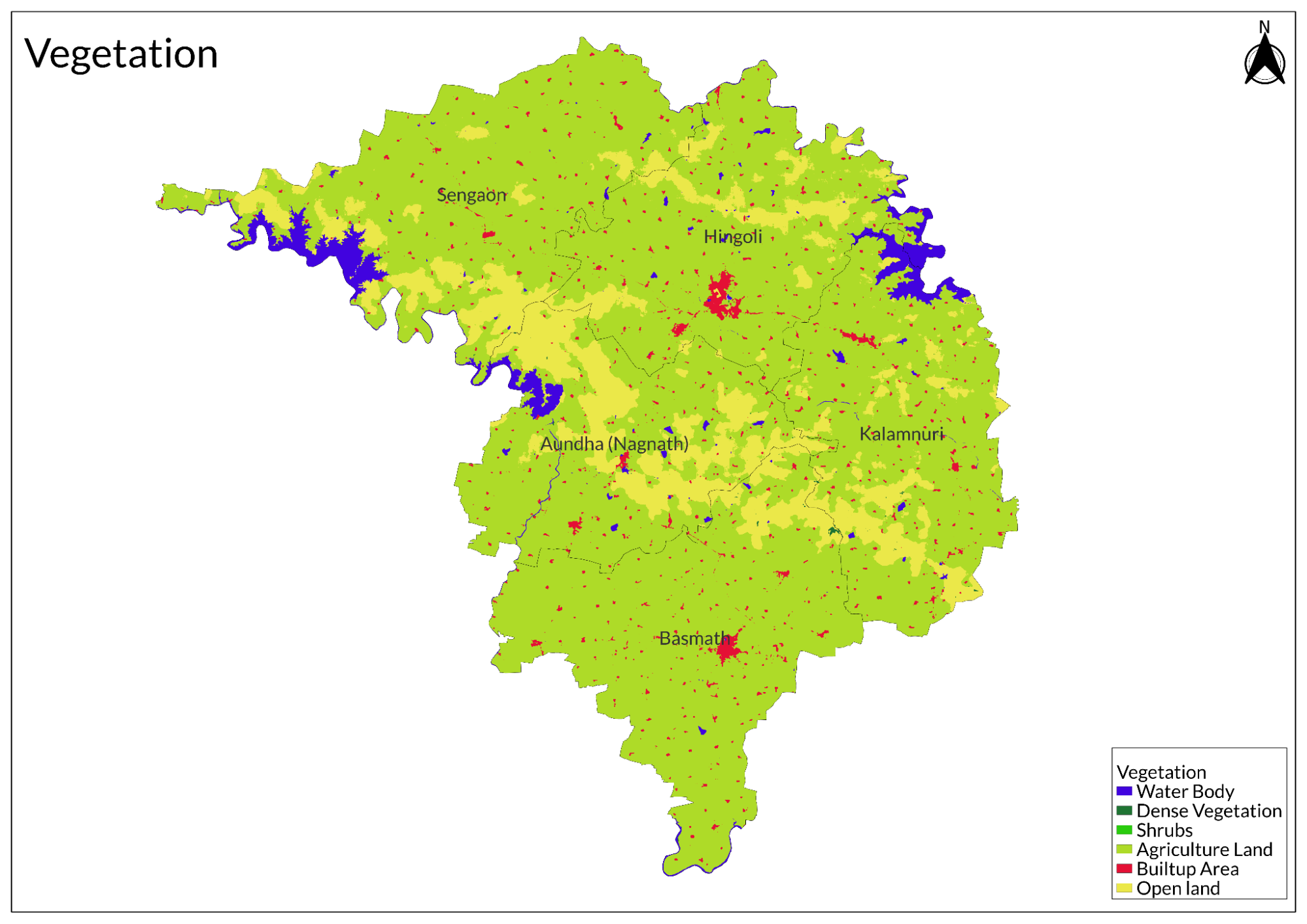
Land Use
Environmental Concerns
Deforestation
Deforestation in Hingoli district, Maharashtra, is primarily driven by agricultural activities. As the demand for food products has increased, trees are frequently cut down to clear land for crops and grazing areas for cattle. This practice has significant implications for the region's forest cover.
As of 2020, Hingoli had approximately 1.39 thousand hectares of natural forest, which accounted for only 0.30% of the district's total land area. The largest forested region is found in Aundha taluka, covering about 10,432 hectares. However, the ongoing expansion of agriculture continues to threaten these remaining forest areas.
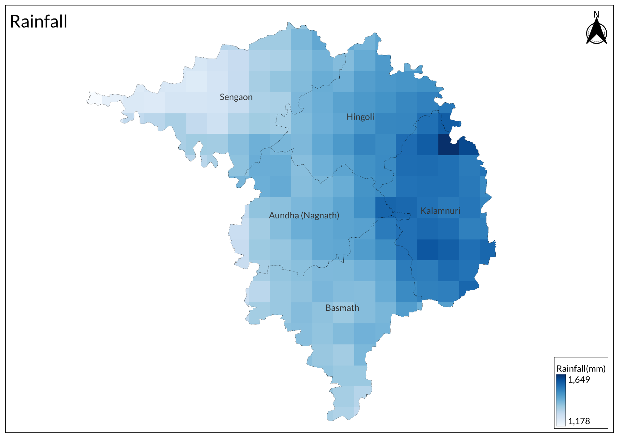
Water Scarcity
Hingoli district in Maharashtra faces significant water scarcity primarily due to the over-extraction of groundwater for irrigation and other uses. The rapid depletion of groundwater levels is aggravated by low rainfall, particularly in the Marathwada region, which historically receives less monsoon precipitation. This has led to an unsustainable rate of groundwater extraction that exceeds natural replenishment.
The situation is further complicated by high concentrations of nitrates in the groundwater, negatively impacting water quality. Villages such as Chondi Khurd have reported acute water shortages, highlighting the dire consequences of this crisis. Additionally, the quality of drinking water in some areas is compromised by elevated levels of iron, fluoride, and nitrate, posing health risks to residents.
Conservation Efforts/Protests[4]
BASF India, in partnership with the NAAM Foundation, has completed a vital water conservation project in Hingoli, Maharashtra, benefiting over 5,000 families in Bhingi, Ambala, and Waranga Masai. The initiative involved widening a 3 km water canal in Bhingi, rejuvenating a percolation tank in Ambala, and constructing a farm pond in Waranga Masai, ensuring sustainable water access. Inaugurated at a handover event attended by BASF India executives and NAAM Foundation representatives, Managing Director Alexander Gerding highlighted water security as a fundamental right, hoping to inspire similar efforts in other villages.
Graphs
Water
Climate & Atmosphere
Forests & Ecology
Human Footprint
Sources
Central Ground Water Board (CGWB), Ministry of Jal Shakti. n.d.. Department of Water Resources, River Development and Ganga Rejuvenation, Government of India.https://cgwb.gov.in/en
District Hingoli. Government of Maharashtra.https://hingoli.nic.in/
Environmental Information System. Government of India, Ministry of Environment, Forest, and Climate Change.http://www.envis.nic.in/
Forest Survey of India.https://fsi.nic.in/
Geological Survey of India. Ministry of Mines, Government of India.https://www.gsi.gov.in/webcenter/portal/OCBIS
Hingoli, Maharashtra, India: Deforestation Rates & Statistics. n.d. Global Forest Watch.https://www.globalforestwatch.org/country/IN…
Hingoli: Chondi Khurd village faces acute shortage of water. 2023, January 3. The Times of India.https://timesofindia.indiatimes.com/videos/c…
Home Page. Vasantrao Naik Marathwada Krishi Vidyapeeth, Parbhani - 431 402 (Maharashtra).https://www.vnmkv.ac.in/
Indian Biodiversity Information System. https://www.indianbiodiversity.org/
Indian Council of Agricultural Research. [Ministry of Agriculture and Farmers Welfare].https://icar.gov.in/
Lokhande, A. 2025, February 25.Haryana Free Sauchalay Yojana 2025. Gecsamastipur.https://gecsamastipur.org.in/
Maharashtra Pollution Control Board.https://mpcb.gov.in/
Maharashtra Remote Sensing Application Centre. 2025, February 18.https://mrsac.gov.in/MRSAC/
Zoological Survey of India. Government of Environment, Forest, and Climate Change.https://zsi.gov.in/
Last updated on 6 November 2025. Help us improve the information on this page by clicking on suggest edits or writing to us.