Contents
- Physical Features
- Climate
- Geology
- Soil
- Minerals
- Rivers
- Botany
- Wild Animals
- Birds
- Forest Reserves
- Yawal Wildlife Sanctuary
- Land Use
- Environmental Concerns
- Deforestation
- Water Scarcity
- Soil degradation
- Industrial Pollution
- Environmental NGOs
- Graphs
- Water
- A. Rainfall (Yearly)
- B. Rainfall (Monthly)
- C. Evapotranspiration Potential vs Actual Numbers (Yearly)
- D. Annual Runoff
- E. Runoff (Monthly)
- F. Water Deficit (Yearly)
- G. Water Deficit (Monthly)
- H. Soil Moisture (Yearly)
- I. Seasonal Groundwater Levels: Bore Wells
- J. Seasonal Groundwater Levels: Dug Wells
- Climate & Atmosphere
- A. Maximum Temperature (Yearly)
- B. Maximum Temperature (Monthly)
- C. Minimum Temperature (Yearly)
- D. Minimum Temperature (Monthly)
- E. Wind Speed (Yearly)
- F. Wind Speed (Monthly)
- G. Relative Humidity
- Human Footprint
- A. Nighttime Lights
- Sources
JALGAON
Environment
Last updated on 6 November 2025. Help us improve the information on this page by clicking on suggest edits or writing to us.
Jalgaon, a district in northern Maharashtra, is recognised for its agricultural success, particularly in banana cultivation, while also featuring a diverse natural environment. The district includes areas of lush greenery, small forested regions, and significant water bodies such as the Girna and Tapi rivers, which play a crucial role in sustaining its ecosystems and agricultural activities.
Physical Features
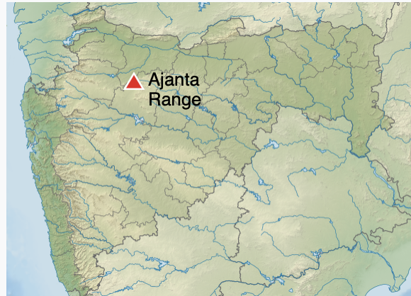
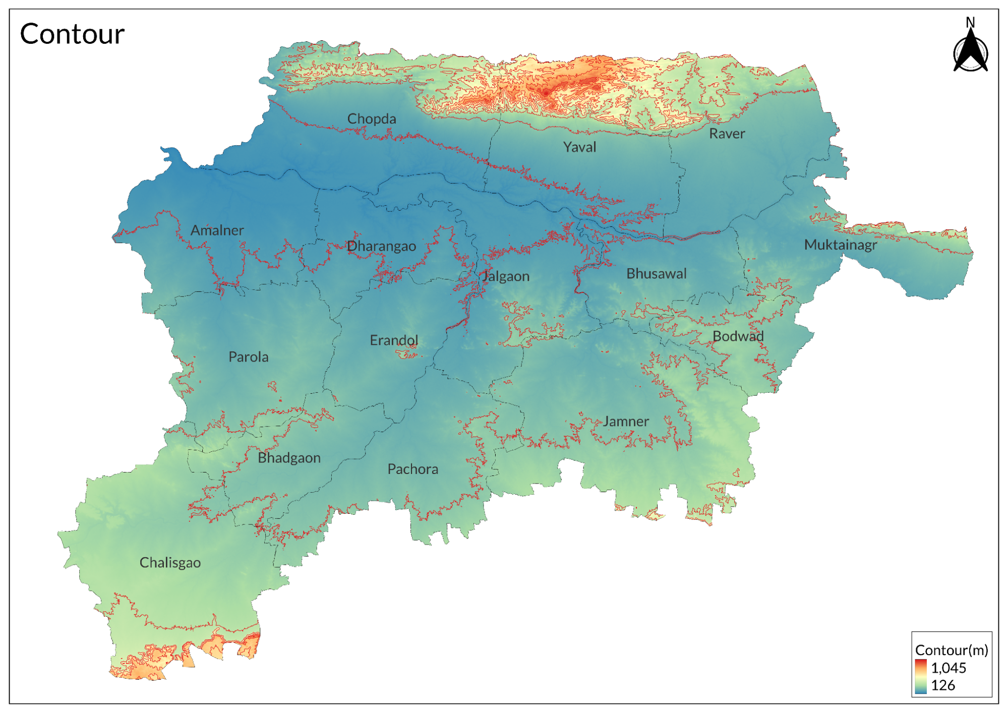
Jalgaon district occupies a significant geographical position in the northern part of Maharashtra, India, situated between 20° and 21° north latitude and 74°55' to 76°28' east longitude. The district's landscape is dominated by the impressive Satpura mountain ranges along its northern boundary, reaching elevations of 460-600 meters, with prominent peaks like Yawal rising to 850 meters. These mountains feature complex geological formations with steep escarpments and deep valleys that create unique microhabitats.
The central region of Jalgaon comprises extensive agricultural plains characterised by gentle slopes with 1-2% gradients and rich alluvial deposits. These flatlands are intersected by well-developed irrigation networks that support the region's agricultural activities. The river valleys cutting through the district create deep channels flanked by flood plains with distinct soil profiles, forming natural drainage systems and ecological transition zones that contribute to the region's biodiversity.
Climate
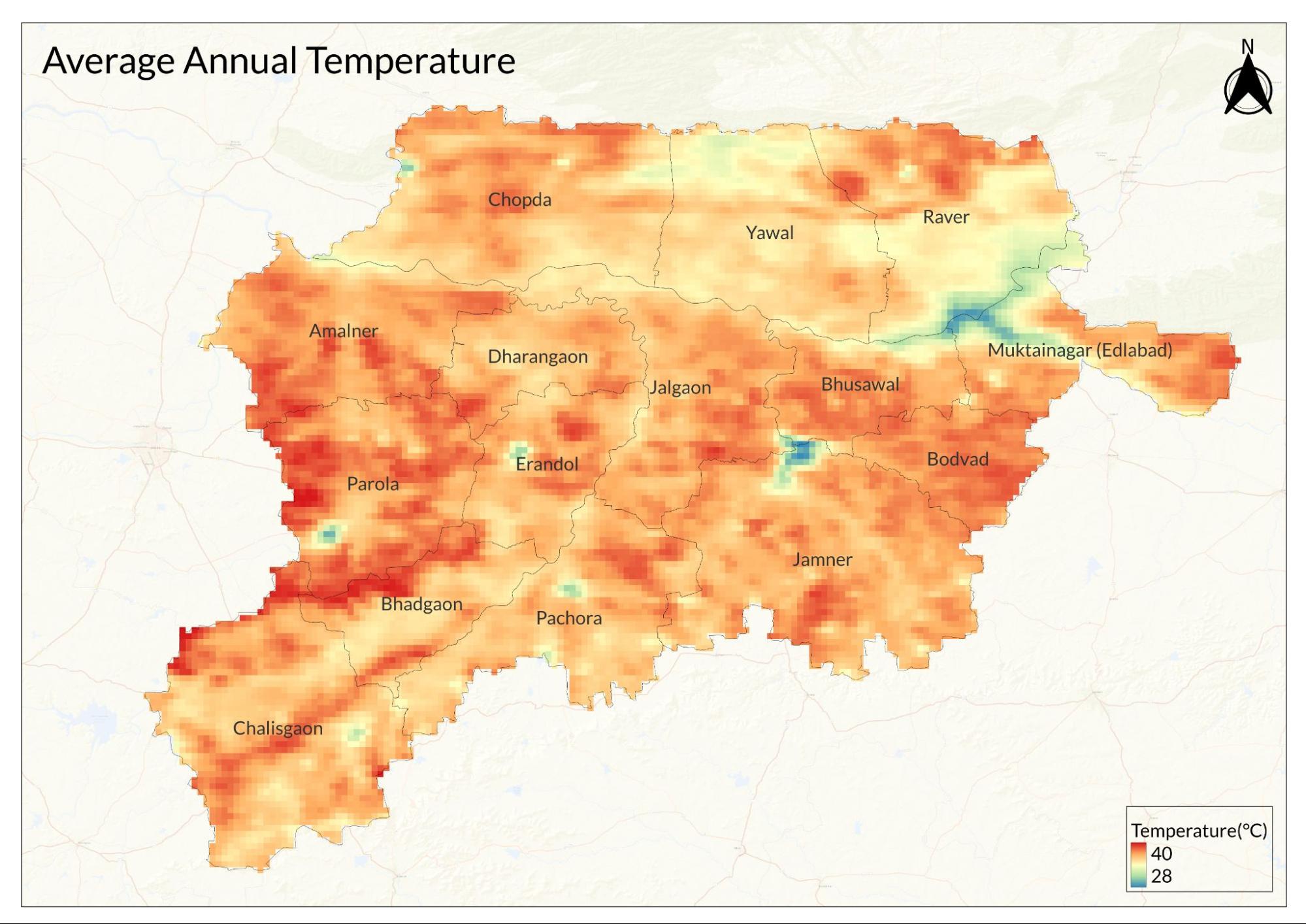
The climate of Jalgaon is characterised by distinct seasonal variations that significantly influence the region's ecology and agricultural patterns. Summers, extending from March to June, are notably hot with temperatures ranging from 32°C to 45°C, and maximum recorded temperatures reaching 47.8°C. This season experiences strong dry winds from the northwest and extremely low humidity levels of 15-30%, resulting in high evaporation rates averaging 12.5 mm/day.
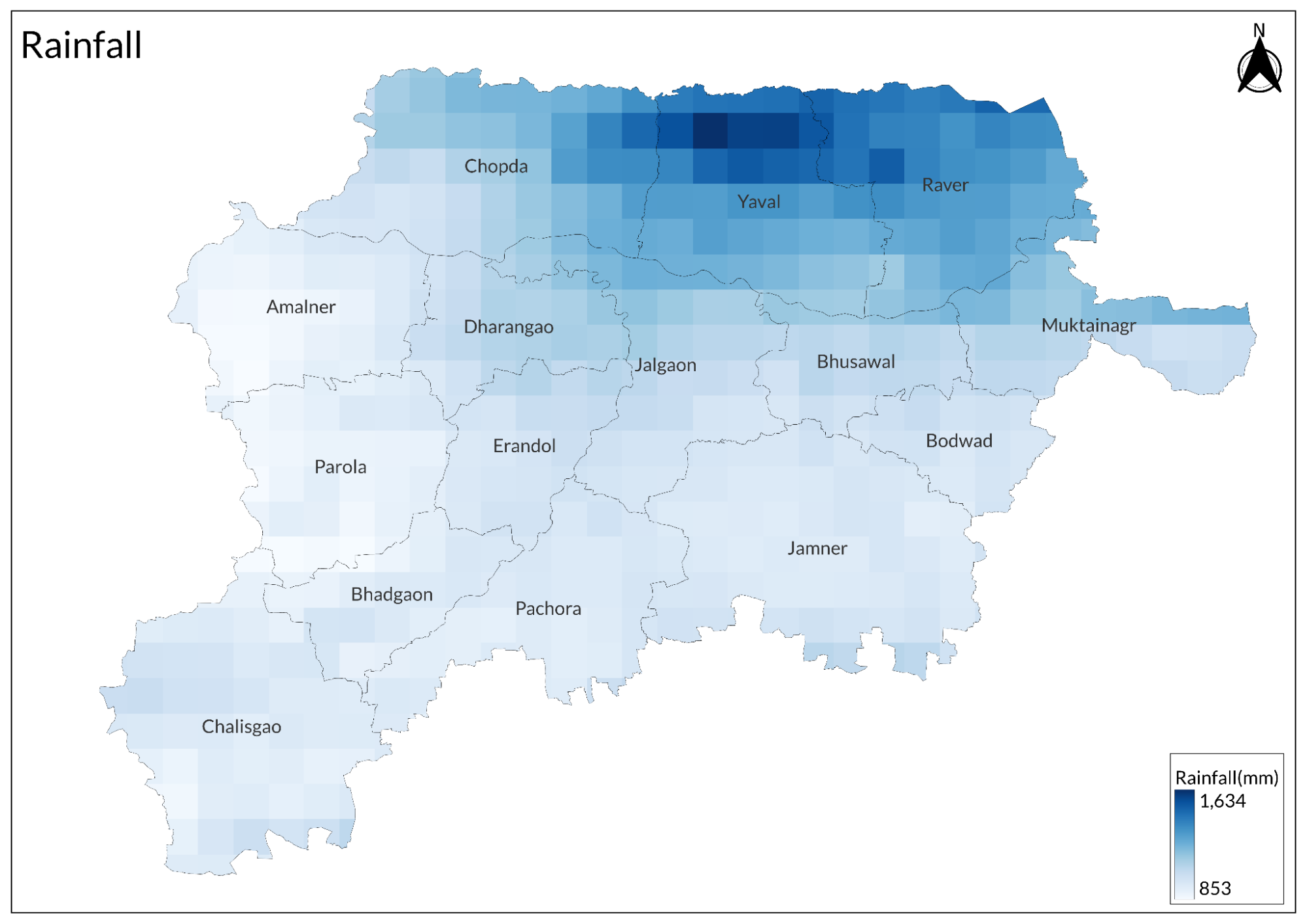
The monsoon season arrives in July and continues through September, bringing vital precipitation to the region. Annual rainfall averages between 700-800 mm, distributed across 45-50 rainy days. During this period, humidity levels surge to 65-85%, and cloud cover typically ranges from 6-8 oktas. The region occasionally experiences heavy downpours exceeding 100mm/day, which significantly impact local hydrology and agriculture.
Winters, spanning from November to February, provide relief with moderate temperatures ranging from 12°C to 28°C, with the lowest recorded temperature being 8.3°C. This season is characterised by morning fog occurring for 10-15 days, moderate humidity levels of 30-45%, and generally clear skies with occasional western disturbances. The region remains frost-free throughout the winter, benefiting agricultural activities.
Geology
The geological foundation of Jalgaon is predominantly composed of Deccan Trap basalts, which cover approximately 85% of the district's area. These basaltic formations resulted from multiple lava flows dating back 65 to 62 million years, with thickness varying from 200 to 1000 meters. The basalts exhibit distinctive features, including columnar jointing and vesicular and amygdaloidal textures, which influence local groundwater movement and soil formation.
Alluvial deposits form another significant geological feature, particularly along river valleys. These deposits, ranging from recent to sub-recent periods, reach thicknesses of up to 30 meters and consist of stratified layers of sand, silt, and clay. The region also displays various structural features, including fault lines, lineaments, and dyke swarms, which have played crucial roles in shaping the local landscape and mineral distributions.
Soil
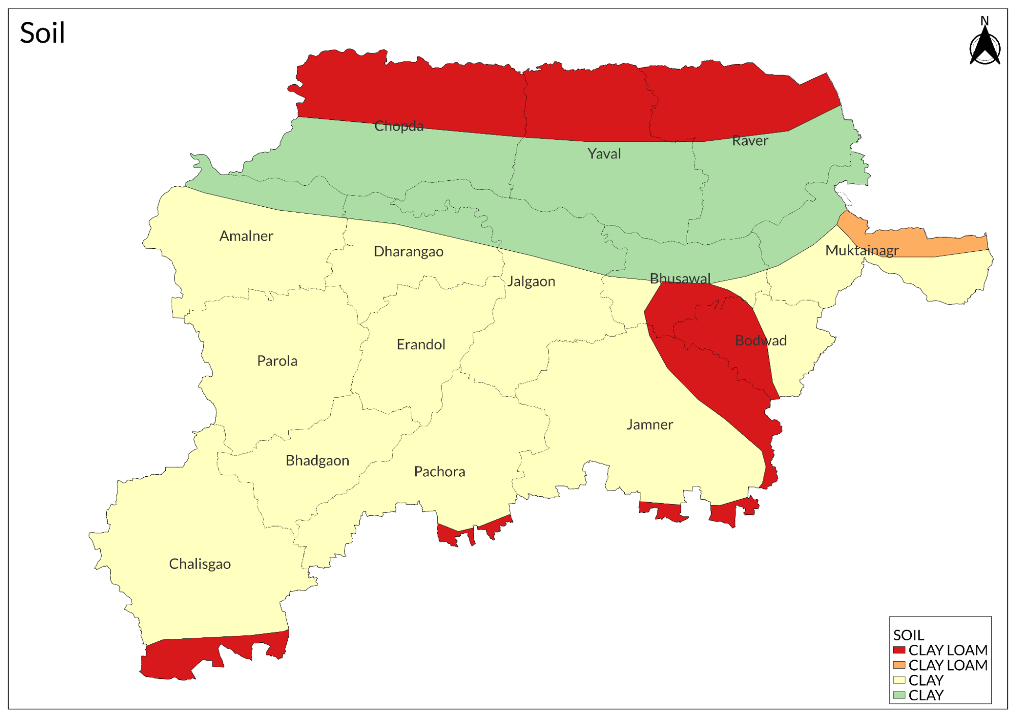
The predominant soil is the deep black cotton soil, extending beyond one meter in depth, with clay content ranging from 40-60% and a pH of 7.5-8.5. This soil type is particularly valued for its high water retention capacity and richness in calcium and magnesium, making it ideal for cotton cultivation.
Medium black soil, found in significant portions of the district, ranges from 0.5-1 meter in depth with 30-40% clay content, offering good drainage characteristics and moderate fertility suitable for diverse cropping patterns. Light black soil, typically 0.3-0.5 meters deep, features lower clay content and quicker drainage, requiring more frequent irrigation but proving suitable for cereals and pulses. The hilly areas contain lateritic soil, characterised by high iron content and acidic nature (pH 5.5-6.5), with limited agricultural potential but significant ecological value.
Minerals
The region is primarily known for its rich black cotton soil, technically called regur, which is derived from basaltic rock and contains important minerals like calcium, magnesium, and potassium. This mineral-rich soil makes the region exceptionally fertile for agriculture.
The district contains notable deposits of coal, particularly in the surrounding areas, though these are not as extensively mined as in other parts of Maharashtra.

Clay deposits are found in various parts of the district, supporting small-scale pottery and brick-making industries. The region also contains basalt rock formations, which are quarried for construction purposes and road building.
The geological formation of the region, being part of the Deccan Traps, has resulted in the presence of various other minor minerals and semi-precious stones in certain areas. However, large-scale mining operations are limited, with the primary focus remaining on utilising the mineral-rich soil for agricultural purposes.
The natural weathering of the basaltic rocks has contributed to the formation of fertile soil that contains various micronutrients, making Jalgaon particularly suitable for crops like bananas and cotton. This natural mineral composition has played a crucial role in establishing the region as an agricultural hub.
Rivers
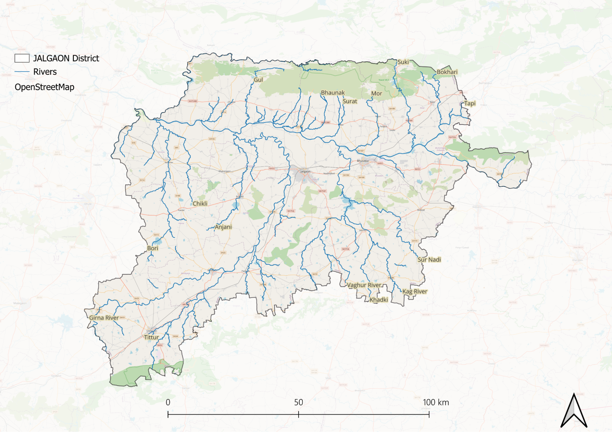
The Girna River, originating from the Kalsubai ranges in the Western Ghats at an elevation of 1,034 meters, flows for approximately 425 km through the Jalgaon district.

The river's catchment area spans 10,000 square km, supporting over 200 villages and towns. Its major tributaries include the Manyad, Titur, and Panjhra rivers.
The Waghur River system features the Waghur Dam, constructed in 1978 with a height of 40 meters and a length of 3,080 meters. The reservoir has a storage capacity of 227.45 million cubic meters and irrigates approximately 50,000 hectares. The dam's command area covers 68 villages across Jalgaon and Bhusawal talukas. The regulated water release maintains a flow rate of 2.5 to 3 cumecs during peak agricultural seasons.
The Tapi River, stretching 724 km, forms the northern boundary of Jalgaon for about 180 km. Its floodplains extend 2-5 km on either bank, depositing rich alluvial soil during monsoons. The river maintains an average annual flow of 489 cubic meters per second at Jalgaon. Major Tapi tributaries near Jalgaon include the Purna and Aner rivers. The river significantly influences groundwater tables up to 15 km from its banks and supports unique riparian ecosystems.
Botany
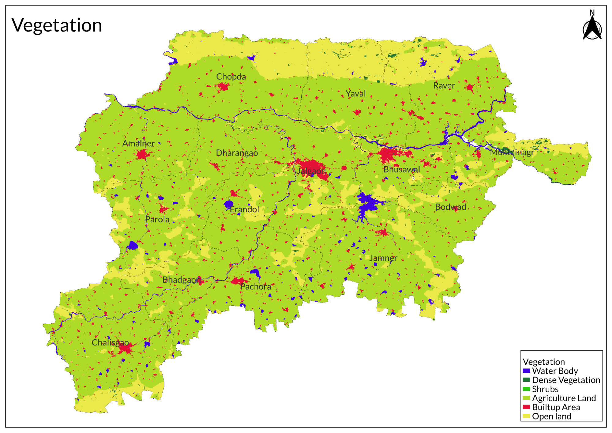
As India's largest banana producer, the district dedicates over 50,000 hectares to banana cultivation, primarily of the Grand Naine variety. Cotton cultivation follows as the second major crop, covering approximately 40,000 hectares, with H-6 and H-8 varieties dominating the fields. The agricultural spectrum includes jowar (sorghum), wheat, groundnut, and sugarcane, which together constitute about 60% of the cultivated area.
The indigenous flora consists primarily of dry deciduous species, with neem, babul, khair, and palas being prominent. Scattered teak plantations and natural stands exist throughout the region. The understory vegetation features species like Karvy and lantana. Forest areas, occupying about 15% of the district's total area, comprise Southern Tropical Dry Deciduous forests, concentrated in the Satpura ranges and along river valleys.
The region harbours significant populations of medicinal plants, including adulsa, nirgudi, and bel. These species occur naturally and are also cultivated under medicinal plant conservation programs. The district's protected forests and social forestry plantations serve dual purposes of preventing soil erosion and providing fuelwood to local communities.
Wild Animals
Leopards are present in Jalgaon district, particularly in the Satpura foothills and along the Tapi River. The forest department tracks their movements and interactions with humans. On average, there are 30-40 leopard sightings annually, with the highest concentrations in the Yawal and Raver regions.
Wild boars inhabit forests and farms, with an estimated population of 2,000-2,500. They frequently move between the Satpura ranges and agricultural areas, causing crop damage. Indian grey mongoose occurs throughout the district, with higher densities near settlements. The mammal population includes jungle cats, particularly in grasslands, jackals with packs of 4-6 individuals common near villages, and Indian foxes in scrubland areas. Small mammals like palm civets, Indian hare, and several species of bats form the prey base. The district also supports populations of striped hyenas and sloth bears in the protected forest areas.
Birds
The bird diversity of Jalgaon district includes resident, migratory, and locally moving birds. Indian Peafowl populations are stable in agricultural areas and forest edges. Grey Francolins live in scrubland and field margins, while Red-wattled Lapwings nest in fallow fields.
Water birds include Little Egrets, Grey Herons, and Indian Pond Herons along rivers and water bodies. The Waghur Dam attracts winter migrants like Common Pochard and Northern Pintail. Raptors in the district include Black-winged Kites, Shikra, and Short-toed Snake Eagles. Nocturnal species comprise the Spotted Owlet, Barn Owl, and Indian Eagle-Owl. Common agricultural area birds include Red-vented Bulbul, Common Myna, House Sparrow, and Indian Robin. The banyan and peepal trees support colonies of Rose-ringed Parakeets. The Tapi River Corridor serves as a crucial flyway, supporting riverine species like River Terns and Black-bellied Terns.
Forest Reserves
Yawal Wildlife Sanctuary
The sanctuary's vegetation is predominantly Southern Tropical Dry Deciduous Forest, featuring key species like teak, ain, dhawda, and tendu. The forest maintains a three-tiered structure with distinct canopy layers. Wildlife includes leopards, sloth bears, sambar deer, and wild boars. The bird population comprises over 200 species, with significant populations of Indian Peafowl and Grey Junglefowl.

Land Use
Environmental Concerns
Deforestation
Deforestation in Jalgaon district, Maharashtra, has emerged as a significant environmental issue, leading to habitat degradation and fragmentation. As of recent assessments, Jalgaon has experienced a loss of approximately 36 hectares of tree cover from 2001 to 2023, reflecting a 2.7% decrease since 2000. This loss represents about 0.17% of all tree cover loss in Maharashtra. The primary drivers of deforestation in the region include agricultural expansion, construction activities, mining operations, and population growth. Trees are frequently cut down to clear land for crops and grazing areas for cattle, while new infrastructure, such as buildings and roads, further contributes to the loss of forested areas. Additionally, mining activities necessitate the removal of trees, exacerbating the problem.
Water Scarcity
Water scarcity in Jalgaon district, Maharashtra, is a critical issue, affecting both the population and agriculture. With 84% of its 1.8 million people living in water-stressed areas and 29% facing severe shortages, per capita water availability has dropped below 895 m³ per year. Over-extraction of groundwater, low monsoon rainfall, and increasing demand for water-intensive crops like bananas and sugarcane have worsened the crisis. As of May 2024, 75 villages rely on tankers for water, while the Girna Dam stands at just 21% capacity. Additionally, depleted water projects and high nitrate levels in groundwater further threaten the district’s water security.
Soil degradation
Soil degradation in Jalgaon district, Maharashtra, is a major concern, driven by erosion, salinity, and nutrient deficiencies. Water erosion necessitates effective watershed management, while the region’s subtropical climate, with low rainfall and high evaporation, worsens soil salinity. Nutrient deficiencies, particularly in phosphorus, zinc, and iron, are widespread, though the soil remains rich in potassium and sulfur. Additionally, irrigated and calcareous soils suffer from lime-induced iron chlorosis, with soil pH ranging from 6.79 to 8.85, making sustainable soil management crucial for maintaining agricultural productivity.
Industrial Pollution
Industrial pollution in Jalgaon district, Maharashtra, is a major environmental concern due to improper waste management from industrial, domestic, and commercial activities. The district generates around 485.68 metric tons of solid waste daily, with 52% being dry and 48% wet, while industrial liquid waste contaminates local water bodies, including the Girna River. Air pollution is also a growing issue, worsened by industrial emissions and high noise levels, particularly during peak hours. The pollution poses serious health risks to local communities, degrades environmental quality, and disrupts ecosystems, prompting an urgent need for better waste management and pollution control measures.
Environmental NGOs
In the Jalgaon district, several environmental NGOs are actively engaged in efforts to preserve and protect the local environment. These organisations focus on various initiatives aimed at promoting sustainability, biodiversity conservation, and community awareness.
Chaatak Nature Conservation Society (CNCS) focuses on conserving biodiversity and natural habitats. Established in 2010, CNCS has made significant strides in promoting bird conservation efforts and has been instrumental in declaring the Hatnur Dam Reservoir as an Important Bird Area (IBA).
Green Jalgaon Foundation is one of the prominent NGOs dedicated to environmental preservation. The foundation emphasises afforestation projects, environmental education, and sustainable living initiatives, aiming to enhance the ecological health of the region.
Jalgaon Nature Club plays a crucial role in wildlife protection and biodiversity conservation. The club conducts awareness programs for local communities, educating them about the importance of preserving natural habitats and the diverse species that inhabit them.
Another key organisation is the Jalgaon Environmental Protection Group (JEPG), which advocates for clean water and anti-pollution measures. JEPG works on waste management solutions and raises awareness about the impact of pollution on health and the environment.
Graphs
Water
Climate & Atmosphere
Human Footprint
Sources
Jalgaon, Maharashtra, India: Deforestation Rates & Statistics. Global Forest Watch.https://www.globalforestwatch.org/country/IN…
M.G, L., S.S, B., & B.V, K. 2016. Ground water pollution near the industrial area at Jalgaon district, Maharashtra state. International Journal of Advanced Research in Chemical Science,3(1).https://doi.org/10.20431/2349-0403.0301007
Naphade, M., Sidhu, G. S., Patil, V. D., & Shinde, R. 2021. Assessment of Macronutrients status of Jalgaon district, Maharashtra state, India. Journal of Emerging Technologies and Innovative Research (JETIR),8(4).https://www.jetir.org/papers/JETIR2104120.pdf
Patil, N. A., & Suryawanshi, D. S. 2016. Tress and Scarcity of Water Resources in the Drought-prone Areas of Jalgaon District in Maharashtra State: A Geographical Perspective.Annals of Natural Sciences,2(1), 14–25.https://www.researchgate.net/publication/305…
Last updated on 6 November 2025. Help us improve the information on this page by clicking on suggest edits or writing to us.