Contents
- Physical Features
- Climate
- Geology
- Soil
- Minerals
- Rivers
- Botany
- Wild Animals
- Birds
- Land Use
- Environmental Concerns
- Water Scarcity
- Industrial Pollution
- Climate Change Vulnerability
- Conservation Efforts/Protests
- JalTara
- Graphs
- Water
- A. Rainfall (Yearly)
- B. Rainfall (Monthly)
- C. No. of Rainy Days in the Year (Taluka-wise)
- D. Evapotranspiration Potential vs Actual Numbers (Yearly)
- E. Annual Runoff
- F. Runoff (Monthly)
- G. Water Deficit (Yearly)
- H. Water Deficit (Monthly)
- I. Soil Moisture (Yearly)
- J. Seasonal Groundwater Levels: Bore Wells
- K. Seasonal Groundwater Levels: Dug Wells
- Climate & Atmosphere
- A. Maximum Temperature (Yearly)
- B. Maximum Temperature (Monthly)
- C. Minimum Temperature (Yearly)
- D. Minimum Temperature (Monthly)
- E. Wind Speed (Yearly)
- F. Wind Speed (Monthly)
- G. Relative Humidity
- Forests & Ecology
- A. Forest Area
- B. Forest Area (Filter by Density)
- Human Footprint
- A. Nighttime Lights
- Sources
JALNA
Environment
Last updated on 6 November 2025. Help us improve the information on this page by clicking on suggest edits or writing to us.
Jalna district, situated in the drought-prone Marathwada region of Maharashtra, faces significant environmental challenges primarily due to its reliance on inconsistent monsoon rains to replenish water sources. The district is heavily dependent on seasonal rainfall, which has become increasingly erratic, leading to recurring water scarcity issues. Additionally, the impacts of climate change, including shifting rainfall patterns and rising temperatures, further complicate the situation for the predominantly agrarian population.
Physical Features
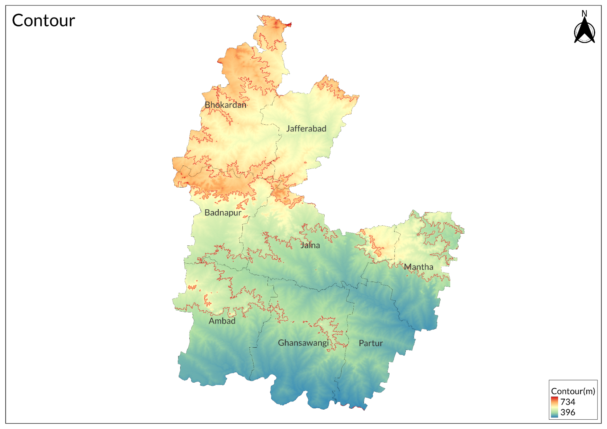
Jalna district of India, Maharashtra, is characterised by a wide array of physical features that contribute to making its geography and environment as unique as they may look. The district covers roughly 7,687 sq km or 2,968 sq miles within longitudes 75.04° E and 76.04° E, stretching between latitudes 19.01° N and 21.03° N. It is located in the Marathwada region and is surrounded by various districts such as Aurangabad on its western side, Jalgaon on the northern side, Buldhana and Parbhani on the eastern side, and Beed on its southern side. The area of the district varies in elevation from approximately 150 meters (492 feet) in the plains around the Godavari River to about 600 meters (1,968 feet) in the hilly areas.
The topography of Jalna is a combination of landforms that have the Ajanta and Satmala hill ranges on the northern part and broad plains sloping gently east and southeast towards the southern part. The central region consists of flat lands and rolling hills that create a diversified landscape for different types of vegetation and agricultural practices. Jalna mostly comprises the Deccan Trap Basalt that dominates the region by occupying an approximate area of 98%. The soil profile in the region has been mainly affected by the basaltic lava flows, which occur as thick layers of the said formation.
Climate
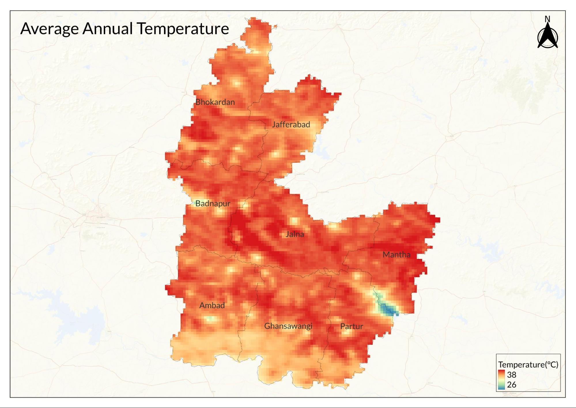
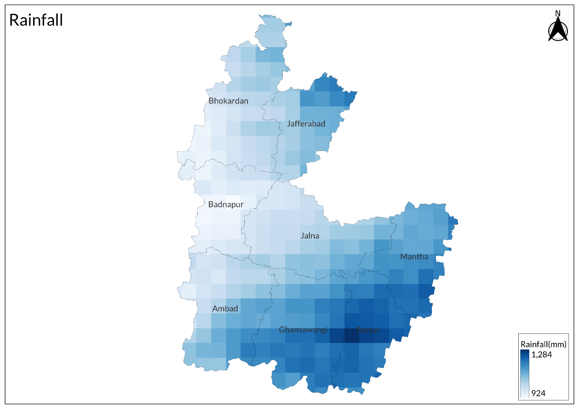
The region experiences a sub-tropical climate that is characterised by distinct seasonal variations influenced primarily by the southwest monsoon. The region receives most of its annual rainfall between June and September, with average annual precipitation ranging from 650 mm to 750 mm. However, during drought years, this can drop to as low as 400 mm to 450 mm. The monsoon season is when the humidity and weather become oppressive, temperatures are mostly between 25°C to 35°C, and it's an extremely lush period for vegetation, as well as agricultural activity.
After the monsoon, winter lasts from October to February and brings cooler temperatures. During this period, nighttime temperatures can go as low as 9°C to 10°C, whereas daytime temperatures can rise up to about 30°C to 31°C. This is essentially a dry season, and the climate is quite pleasing during this time, thus very suitable for outdoor activities, harvesting crops, and many more. The change in climate from the humid monsoon to the cooler winter brings a refreshing change.
Summer is between March and June, during which the temperature is expected to rise to 42°C to 43°C. Heat is very intense during these months, and usually dry with heat waves at times. Humidity increases as summer advances and starts to rise before the monsoon sets in, creating discomfort before the onset of rains.
Throughout the year, temperatures in Jalna fluctuate significantly, with lows peaking at around 10.9°C in winter nights and high as 41.7°C or 107°F during summer. The mean atmospheric temperature is about 26.5°C. Relative humidity averages around 56.6% although it fluctuates a great deal, dropping down to as low as 16% during dry spells to reach as high as 97.6% in peak monsoon conditions.
Wind patterns in Jalna are mild in general, as the mean wind speed levels are at 3.2 m/s, even though, at times, the wind velocity can reach up to about 8.9 m/s. The direction of prevailing winds keeps changing with every season. It has further contributed to temperature variation throughout the year.
Geology
Jalna district is primarily characterised by its extensive Deccan Trap Basalt formations, which are the result of ancient volcanic activity. This geological structure comprises basaltic lava flows that date back to the Late Cretaceous to Eocene age. The lava flows are of considerable thickness, ranging between 20 to 30 meters, and have two distinct units; the upper part is vesicular and filled with secondary minerals such as zeolites and quartz, whereas the lower part is composed of massive basalt. The region's geology is marked by a complex layering of these basaltic flows, shaped by volcanic activity over millions of years.
The topography of Jalna is gently to moderately sloping, with the northern part occupied by the Ajanta and Satmala hill ranges. The elevation of these hills ranges from 600 to 900 meters above mean sea level (amsl), whereas the plains in the southern region range from 450 to 600 meters amsl. The general slope of the district is toward the east and southeast, which adds to the drainage patterns of local rivers like Godavari, Purna, and Dudhna.
In addition to basalts, Jalna also comprises alluvial deposits that exist along the major rivers. The alluvial soils consist of clay, silt, sand, and gravel, and hence support fertile land and agriculture. The thickness of the alluvial deposit may vary from 10 to 20 meters. It helps in supplying adequate groundwater to the region, which is highly required for irrigation and the supply of drinking water. Alluvial regions are significant as they represent the areas of aquifers that may be tapped for extracting groundwater.
The geological composition of Jalna not only influences its physical landscape but also affects its hydrogeology. The district mainly shows moderate to good potential for groundwater in most parts, especially along river banks where alluvial deposits are present. Northern parts of Jalna have highly dissected basaltic plateaus, where the topography may create poorer groundwater potential.
Soil
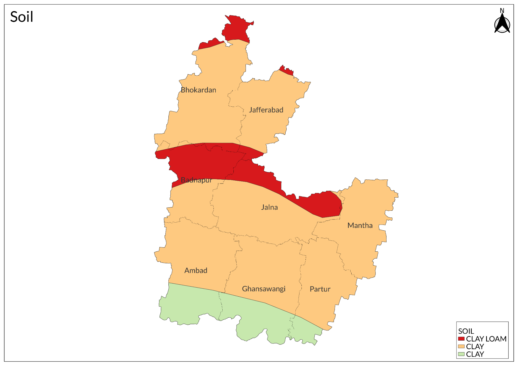
Jalna district of Maharashtra mainly produces black cotton soil. The soil is very fertile and supports the growing of a variety of agricultural activities. This type of soil is mainly found in river valleys. It is deep and rich in nutrients and is very suitable for cotton, soybean, jowar, and bajra. The soil types of the district can be classified into three categories. These are light, medium, and heavy soils.
The hilly and rugged areas of Jalna have less fertile soil with brown to grey colouration. Undulating plains and depressions have medium soils, with dark brown in colour and with better nutrient values. The black cotton soil is deepest in the depressions with better irrigation facilities, such as those located near rivers. They are sticky and may vary greatly in their depth.
The soil of the Jalna region tends to be slightly alkaline, which may in turn affect its fertility. Even though the black cotton soil is nutrient-rich, a deficiency of some minerals, like sulfur, might occur in some sections, which can affect crop productivity. In this region, primarily cash crops such as cotton and soybeans are cultivated by the local farmers because of the supportive nature of the soil.
Minerals
In addition to limestone and other minerals, the mineral wealth of Jalna also consists of clay, which is used in pottery and ceramics, and sand, which is dug out from riverbeds for construction purposes. The district's geological composition primarily consists of Deccan Trap Basalt, which forms a base for these mineral deposits. This basaltic rock formation covers around 98% of the area and influences the availability of minerals in the region.
Moreover, the industrial landscape of Jalna is supported by its mineral resources. The district has several industries that are engaged in agricultural products, steel re-rolling, and seed manufacturing, which use local minerals to enhance their production capabilities.
Rivers
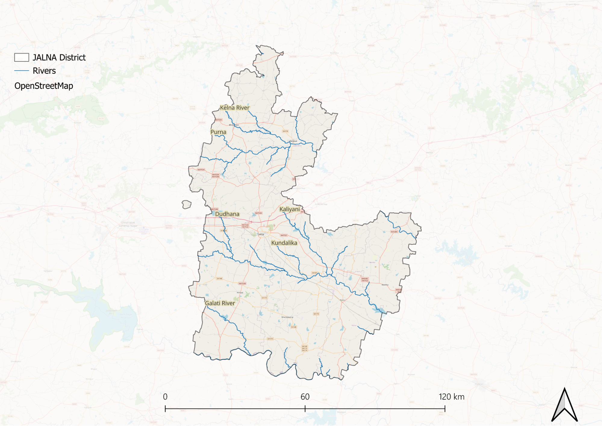
The most important water course is the Godavari River, which forms the whole southern boundary of the district in its course from west to east. It is one of the important rivers of the Deccan Plateau and provides a great source of irrigation and water supply in the area.
The Purna River, one of the most significant tributaries of the Godavari, flows through Jalna and drains a significant part of the district, including places like Jafrabad and Bhokardan. It originates near Mehun, northeast of the Satmala hills, at about 725 meters above sea level. There are many tributaries of the Purna, including the Dudhna, Khelna, Girja, and Charna rivers.
In addition to these major rivers, smaller streams like Gulati flow through the district. The region has a seasonal variation in water level; most of the minor streams dry up during the summer months, while the major rivers are perennial.
Botany
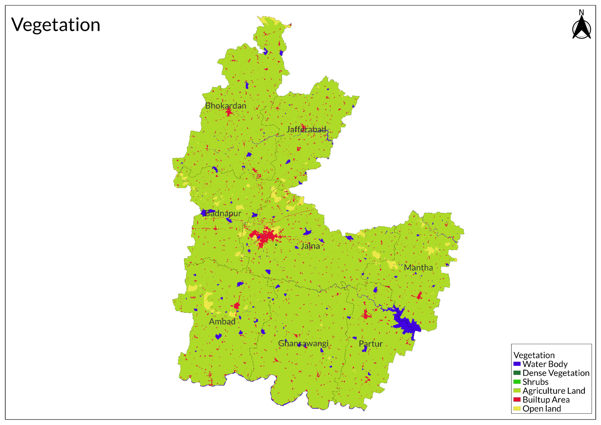
The major vegetation types in the Jalna district are scrub forests, grasslands, and agricultural fields. The vegetation is denser near the banks of the Godavari and Dudhna rivers because of the fertile black cotton soils, which are well-endowed with nutrients. These regions have a rich variety of crops, mainly cotton, soybean, jowar, and bajra, which are essential agricultural products in the district.
Wild Animals
Diverse habitats have been developed over the range of scrub forests to agricultural lands. Panthers (leopards) were seen in relatively more wooded areas, as in regions like Kannad and Fardapur. There are panthers, besides the deer, like chital or spotted deer and barking deer found in the forests. Some other mammals found here include wild boars and sloth bears; however, their population could be small compared to a more protected area.
Birds
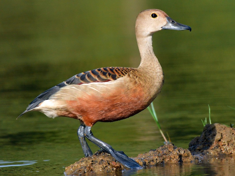
Other significant species include the Indian Grey Hornbill, Common Hoopoe, and various types of cuckoos, such as the Common Koel and Jacobin Cuckoo. The district also hosts migratory birds during certain seasons, including the Greater Flamingo, Eurasian Spoonbill, and Painted Stork.
The region's varied habitats support a wide variety of birds, ranging from raptors like the Short-eared Owl and Rock Eagle Owl to smaller species such as the Purple-rumped Sunbird and various weavers like the Baya Weaver.
Land Use
Environmental Concerns
Water Scarcity
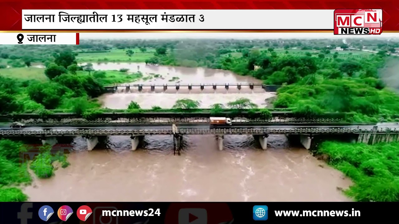
Jalna district in Maharashtra faces significant water-related challenges, primarily due to its dependence on natural resources for agriculture and drinking water. The communities in this region are heavily reliant on monsoon rains, which occur from June to September, as the area experiences a semi-arid climate. Water is essential for both drinking and agricultural purposes, with a notable focus on water-intensive cash crops like cotton. Most farming is rain-fed, and while private dug wells are commonly used for irrigation, there is a growing interest in adopting drip irrigation systems to enhance water efficiency.
The management of water resources in Jalna is complicated by uneven groundwater availability, influenced by the region's diverse geology and variable rainfall patterns. The hydrogeology is characterised by basaltic rock and shallow aquifers, making it challenging to study and manage water resources effectively. During the severe drought of 2012-2013, the district received less than 50% of its average annual rainfall, leading to widespread drying of open dug wells and significant impacts on agriculture.
Despite governmental efforts to provide drinking water through tankers during dry months, the reliance on these services highlights a warning for future water security amid climate change pressures. The lack of maintenance of collective watershed structures further exacerbates vulnerabilities, as many check dams and percolation tanks have fallen into disrepair, limiting their effectiveness in managing water resources.
Participatory drought mapping has revealed that the impacts of drought extend beyond meteorological conditions, affecting soil health and agricultural productivity. Addressing these multifaceted challenges requires a comprehensive approach that considers agricultural practices, hydrological resources, and socio-economic factors to enhance community resilience against climate variability.
Industrial Pollution
Industrial pollution in Jalna district, Maharashtra, is primarily characterised by air quality concerns stemming from emissions produced by industries located in the Maharashtra Industrial Development Corporation (MIDC) area. The main pollutants include sulfur dioxide (SO2), nitrogen oxides (NOx), and particulate matter (PM), which have raised alarms regarding their potential impacts on the local population as air quality index (AQI) levels continue to rise in Jalna city. While studies indicate that the overall air pollution situation in Jalna is not as severe as in other industrial regions, it still falls within the moderately polluted to poor category, particularly near industrial zones.
The primary contributors to industrial pollution in Jalna are metal processing and manufacturing units, especially those engaged in sponge iron and TMT bar production. These industries are known to generate significant particulate emissions during their operations. Monitoring and regulation of these emissions are overseen by the Maharashtra Pollution Control Board (MPCB); however, there are ongoing concerns about enforcement and compliance with pollution control measures.
Air pollution poses serious health risks to the local population, particularly vulnerable groups such as children and the elderly residing near industrial areas. Respiratory issues are a common concern linked to poor air quality. Additionally, improper solid waste management practices within industrial units further contribute to environmental pollution
Climate Change Vulnerability
Jalna district in Maharashtra is recognised as highly vulnerable to climate change, primarily due to its reliance on erratic monsoon rains, decreasing rainfall patterns, rising temperatures, and limited irrigation facilities. These factors frequently lead to droughts, significantly impacting the district's predominantly agricultural economy. A recent study highlighted that Jalna is one of the 11 districts in Maharashtra classified as highly vulnerable to extreme weather events, which collectively account for about 40% of the state's cropped area.
The district experiences frequent droughts attributed to unpredictable and declining rainfall, with reports indicating consecutive years of drought in recent times. Agriculture serves as the primary livelihood for the majority of residents, making them particularly susceptible to fluctuations in weather that directly affect crop yields. The inadequate irrigation infrastructure further exacerbates the situation, limiting farmers' ability to cope with dry spells and increasing their vulnerability during periods of water scarcity.
Groundwater depletion is another critical issue, as over-extraction for irrigation has led to declining water levels, particularly during drought conditions. Additionally, changing rainfall patterns, such as delayed monsoon onset and shorter rainy seasons, disrupt traditional agricultural practices and contribute to reduced soil moisture.
Conservation Efforts/Protests
JalTara
JalTara is a water conservation initiative in Jalna district, Maharashtra, aimed at addressing issues of water scarcity and waterlogging. This project is a collaboration between the Save Groundwater Foundation (SGF) and The Art of Living, focusing on enhancing groundwater recharge through a series of strategic interventions.
The JalTara project operates by training farmers to identify the lowest points on their land where rainwater naturally accumulates. Recharge structures are then constructed at these low points, filled with various sizes of stones to facilitate water percolation. Additionally, fruit-bearing trees are planted on these structures to further enhance the ecosystem. As water seeps through the stones, it replenishes deeper soil layers, significantly increasing groundwater levels.
The benefits of the JalTara initiative are substantial. It has led to increased groundwater levels, improved crop yields, and enhanced farmers' incomes. The project also helps reduce waterlogging and drought conditions, minimises crop spoilage, increases land usability, and creates more employment opportunities for local communities.
Since its inception, JalTara has established around 20,000 recharge structures across more than 50 villages in Maharashtra over the past two years. These efforts aim to extend water availability during dry seasons and combat the adverse effects of climate change on agriculture.
Graphs
Water
Climate & Atmosphere
Forests & Ecology
Human Footprint
Sources
Agriculture Contingency Plan for District Jalna. https://agriwelfare.gov.in/sites/default/fil…
Barkved, L., Ghosh, S., Seifert-Dähnn, I., & Salunke, S. G. 2014. Water resources, water use and potential risks in Jalna: Impacts of extreme drought on water issues and use. NIBR and CICERO.https://www.teriin.org/projects/eva/files/Wa…
Barote, V., Borde, S., & Deshmukh, S. 2017. Redescription Of A Species Of The Genus Eudorylaimus In Jalana District ([M.S.) India .Flora And Fauna,23(2), 468–472.
Bose, M. 2021, August 6.77% of Maharashtra’s cropped area vulnerable to climate change: Study. Deccan Herald.https://www.deccanherald.com//india/77-of-ma…
Forest/Wildlife. Directorate of Tourism, Department of Tourism, Government of Maharashtra.https://maharashtratourism.gov.in/tourist-in…
Industrial Potential Survey of Jalna District. SISI, Mumbai.https://dcmsme.gov.in/dips/IPS-Jalna%20Profi…
Jalna Maharashtra Project. 2023. The Art of Living: Social Projects.https://waterconservation.artofliving.org/ou…
Jalna, Maharashtra, India. iNaturalist.https://www.inaturalist.org/places/jalna
Jalna, Maharashtra, India—Ebird. (2025, February 23).https://ebird.org/region/IN-MH-JN
Misal, P. J. 2020. Biodiversity of Fish Fauna in Jivrekha Reservoir Akola Dev District Jalna, Maharashtra. Indian J. Applied & Pure Bio,35(2), 289–292.https://doi.org/https://www.biology-journal.…
Patekar, S., & Urdukhe, Y. 2023. Traditional Medicinal Plants Used by Local People in Jalna District: A Review of the Ethno-Medicinal and Pharmacological Evidence.Discovery Journal,1(1).https://discoveryjournal.in/dashboard1/paper…
Plantation Program: Sand Ghats At Jalna District. 2021, May. Enviro Techno Consult Private Limited.https://environmentclearance.nic.in/Download…
Last updated on 6 November 2025. Help us improve the information on this page by clicking on suggest edits or writing to us.