Contents
- Physical Features
- Climate
- Geology
- Soil
- Minerals
- Rivers
- Botany
- Wild Animals
- Forest Reserves
- Chaprala Wildlife Sanctuary
- Bhamragarh Wildlife Sanctuary
- Dajipur Wildlife Sanctuary
- Land Use
- Environmental Concerns
- River Pollution
- Air Pollution
- Deforestation
- Waste Management
- Water Scarcity
- Human Wildlife Conflict
- Conservation efforts/Protests
- Rankala Lake Protests
- Nagpur-Goa Shaktipeeth Expressway
- Panchganga River
- Environmental NGOs
- Asmita Mahila Vikas Mandal
- Action For Human Rights
- Republican Social Foundation
- Samrat Charitable Trust Akivat
- Shri Datta Sevabhavi Sanstha Nrusinhwadi
- Graphs
- Water
- A. Rainfall (Yearly)
- B. Rainfall (Monthly)
- C. Evapotranspiration Potential vs Actual Numbers (Yearly)
- D. Annual Runoff
- E. Runoff (Monthly)
- F. Water Deficit (Yearly)
- G. Water Deficit (Monthly)
- H. Soil Moisture (Yearly)
- I. Seasonal Groundwater Levels: Bore Wells
- J. Seasonal Groundwater Levels: Dug Wells
- Climate & Atmosphere
- A. Maximum Temperature (Yearly)
- B. Maximum Temperature (Monthly)
- C. Minimum Temperature (Yearly)
- D. Minimum Temperature (Monthly)
- E. Wind Speed (Yearly)
- F. Wind Speed (Monthly)
- G. Relative Humidity
- Human Footprint
- A. Nighttime Lights
- Sources
KOLHAPUR
Environment
Last updated on 6 November 2025. Help us improve the information on this page by clicking on suggest edits or writing to us.
Kolhapur district, located within the verdant Western Ghats, is characterized by a rich natural environment that includes dense forests, fertile agricultural land, and a wide variety of flora and fauna. The region's rivers, such as the Panchganga and Krishna, are crucial for maintaining both agricultural productivity and ecological balance. As Kolhapur features a blend of urban and rural landscapes, it faces the challenge of reconciling rapid industrial development with the need for environmental conservation, making the adoption of sustainable practices essential for its future.
Physical Features
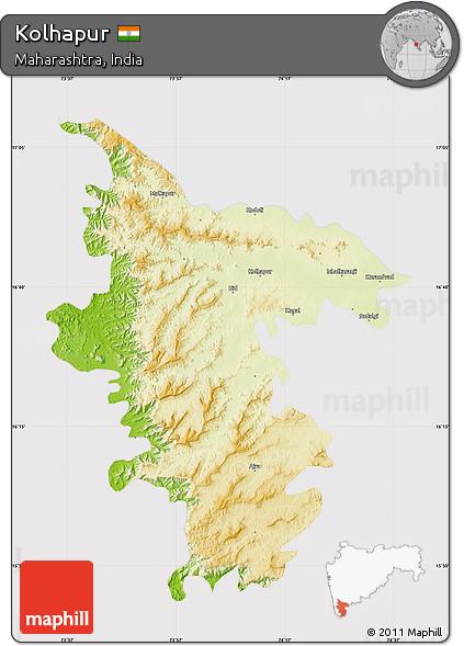
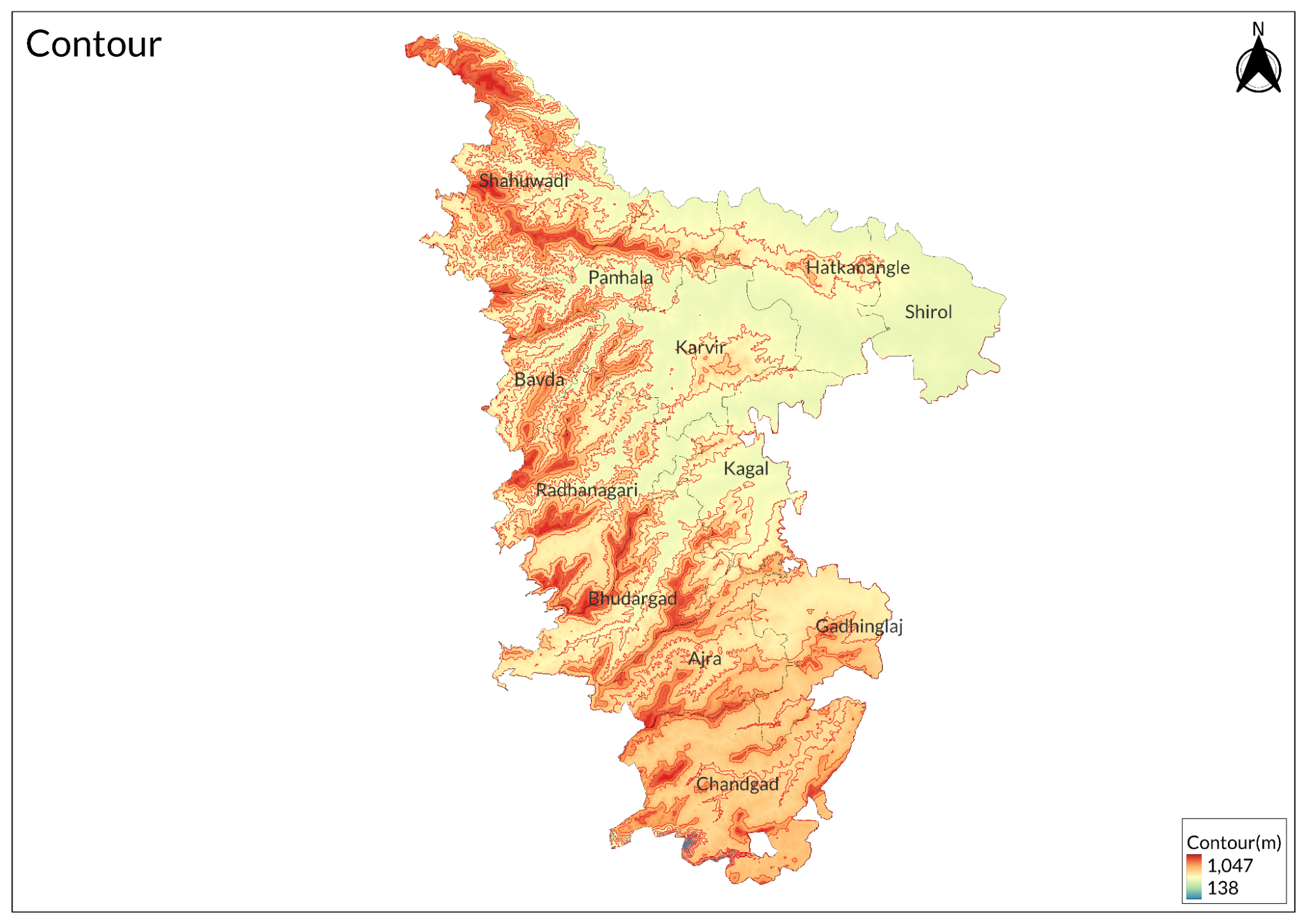
Kolhapur is located in the southwestern part of Maharashtra, situated at an elevation of 546 meters above mean sea level and covering an area of 7,685 square kilometers. The district is bordered by Sangli district to the north, Ratnagiri district and Sindhudurg to the west, and Karnataka state to the east. It is divided into 12 tehsils.
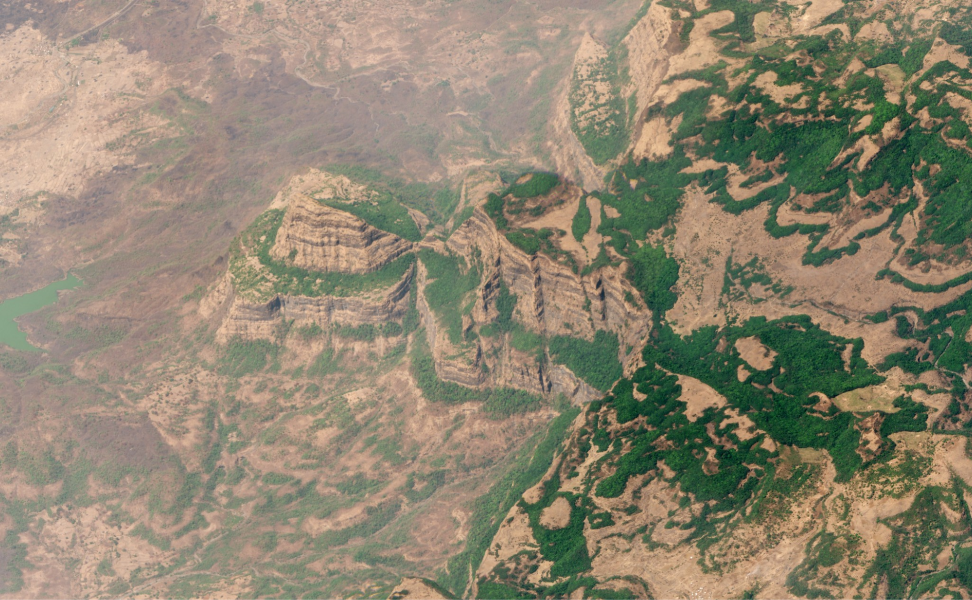
The district can be categorized into three distinct geographical belts: the hilly and rugged terrain of the Western Ghats in the west; the Sahyadri range, which lies in the western part of Kolhapur; and the plains towards the east. Amba Ghat is a well-known hill station within this region, situated at a height of 609 meters above mean sea level. The central portion features narrow, broken-crested ridges that stretch eastward.
Two forest reserves are found in the Sahyadri range of the district: Chandoli National Park on the northwestern side and Radhanagari Wildlife Sanctuary in the southwestern part. The Vishalgad-Panhala range, part of the Western Ghats, extends eastward, starting from a peak at 1,025 meters and remaining above 914 meters for approximately 48 kilometers before descending toward the Krishna basin.
The district is drained by two major rivers: the Krishna and Panchganga. The range has flat tops, particularly around Panhala and Jyotiba, with heavily eroded sides that create small hills and terraces suitable for farming and villages. Numerous roads traverse gaps in this range. Historically, Panhala served as a fort and is now a hill station, while Jyotiba is recognized as a pilgrimage site. The western side is characterized by dense forests that gradually transition into scrub and grassland as one moves eastward.
Kolhapur district is renowned for its historical forts, primarily constructed by the Maratha rulers during the reign of Chhatrapati Shivaji Maharaj in the 17th century. There are a total of 13 hill forts scattered throughout the district.
Climate
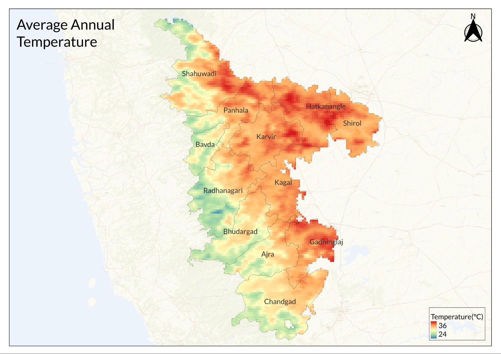
The daily average temperature in the district ranges from 24°C to 29°C. Summer lasts from March to May, with average daily high temperatures exceeding 34°C. April is the hottest month, featuring an average high of 37°C and a low of 22°C. The rainy season occurs from June to October, followed by winter from November to February. During winter, the average daily high temperature remains below 28°C. December is the coldest month of the year, with an average low of 17°C and a high of 29°C.
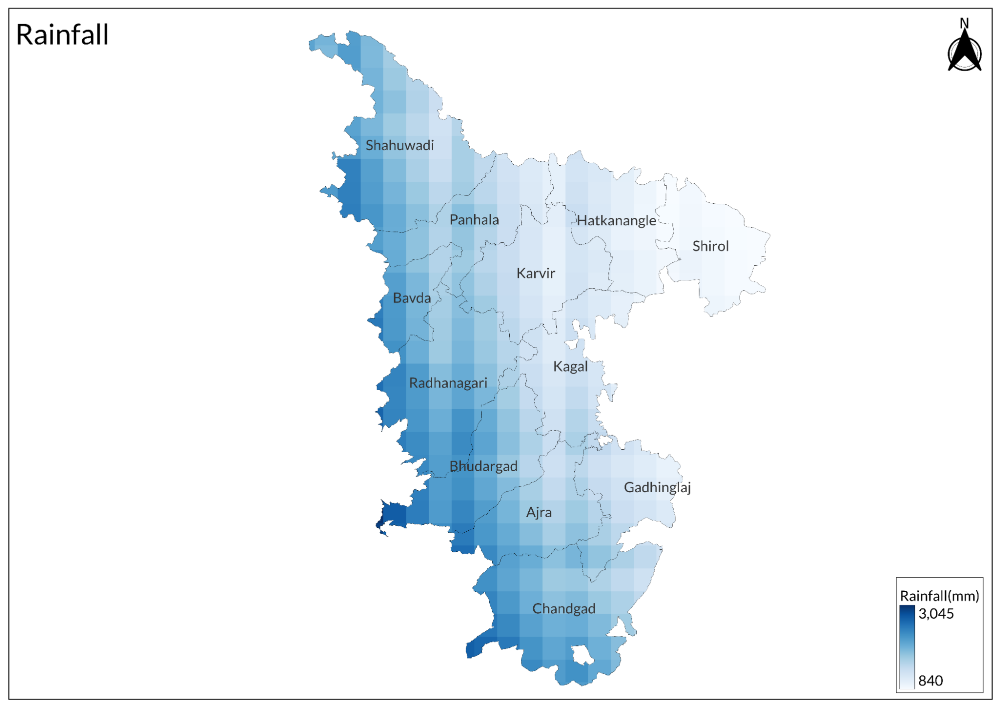
Kolhapur district experiences significant rainfall variations, with annual precipitation ranging from 500 mm in the eastern regions to over 6000 mm in the western Ghats, as per the report by the Ministry of Water Resources in 2013. The district's average annual rainfall is approximately 1239 mm, primarily received during the southwest monsoon season from June to September. The monsoon rains are crucial for agriculture and groundwater recharge, but the uneven distribution often leads to localized water shortages, particularly in the eastern plains. The western parts, including Gagan Bavda and Radhanagari, receive the highest rainfall, contributing to dense forests and perennial water sources, while the drier eastern areas, such as Shirol and Kurundawad, depend more on irrigation. Despite the overall high rainfall, the district faces water scarcity in some regions due to rapid runoff in hilly terrains and the limited storage capacity of basaltic rock formations. To address these challenges, experts emphasize the need for rainwater harvesting, groundwater conservation, and afforestation efforts to enhance water retention and mitigate seasonal shortages.
Geology
The Deccan trap formation is seen spread over almost the entire district.
The Deccan Traps, a vast igneous province in west-central India, significantly shape Maharashtra's geology. Formed by massive volcanic eruptions around 66 million years ago during the late Cretaceous period, these eruptions led to extensive basalt lava outpourings, creating thick, layered rock formations. The lava flows, known as the "Deccan Trap," were produced through fissure eruptions, with time lags between volcanic episodes marked by freshwater sediment deposits called inter-trappean beds. Maharashtra lies at the core of the Deccan Traps, covering approximately 2,46,784 sq. km, which is about 82% of the state's land area, as per GSDA Maharashtra, and is present in all districts except Bhandara. These formations extend up to 1,636 meters above mean sea level and to considerable depths below sea level. The Deccan Trap is a vast accumulation of volcanic products, including tuff, breccia, and ash beds. The lava flows can be broadly classified into four major physical units: massive and compact, vesicular, amygdaloidal (zeolitic), and jointed or fractured brecciated formations. Often associated with pyroclastic and sedimentary beds, these flows include sandstones, clays, limestones, and cherts, while another distinct layer, known as red bole, appears as a clay-like deposit. Additionally, intrusive dykes sometimes cut through multiple lava flows, creating significant physiographic features. The Deccan Traps flows erupted from long, narrow fissures, covering vast areas compared to their thickness. Individual flows range from just a few meters to as much as 30–35 meters thick, with the western part of Maharashtra exhibiting the greatest accumulation, up to 3,000 meters, while the flows thin out entirely towards the east, near Nagpur. Over time, the weathering of basalt has given rise to fertile black soil (regur), ideal for cotton cultivation, which plays a crucial role in Maharashtra's agricultural economy. Furthermore, the Deccan Traps significantly influence water resources by impacting groundwater retention and recharge, making them vital for both agriculture and water management in the region.
Soil
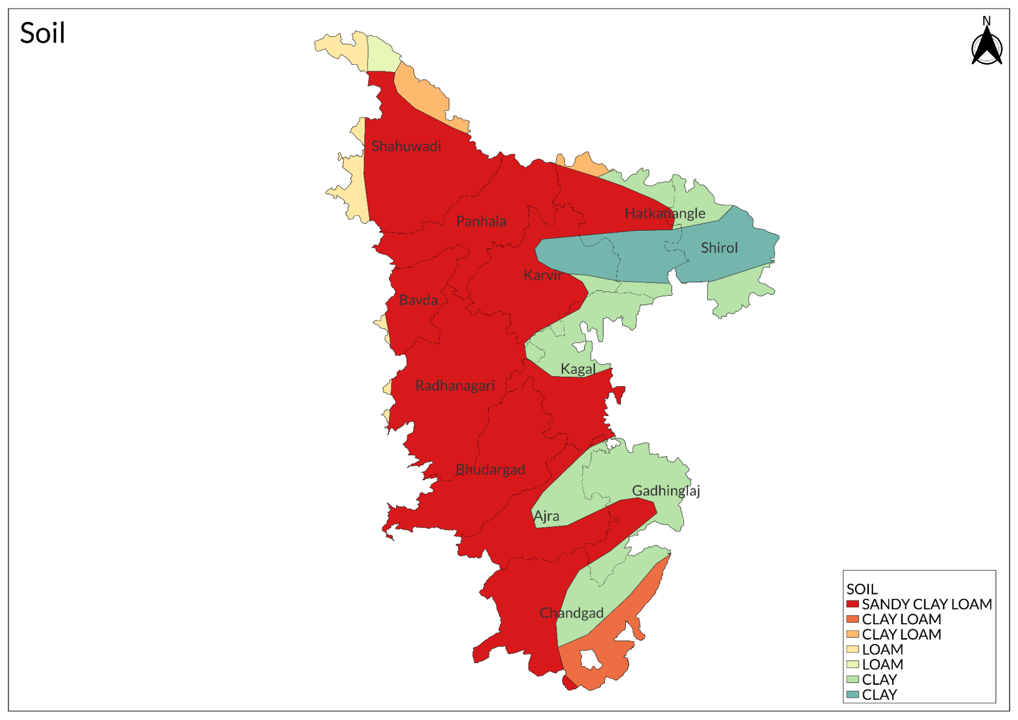
The major portion of the soil is derived from red lateritic soil and yellowish-brown soil. The medium black soil is prevalent in most parts of Dhanora, Kurkheda, Etapalli, Aheri, and some areas of the remaining block, followed by deep black soil.
Minerals
Baryte, dolomite, quartz, and colored granite, along with iron ore deposits, are found in the Surjagad and Bhamragad areas of the district. Limestone deposits are located in the Devalmali and Katepalli areas, while diamonds are observed in Vairagad within the district.
Rivers
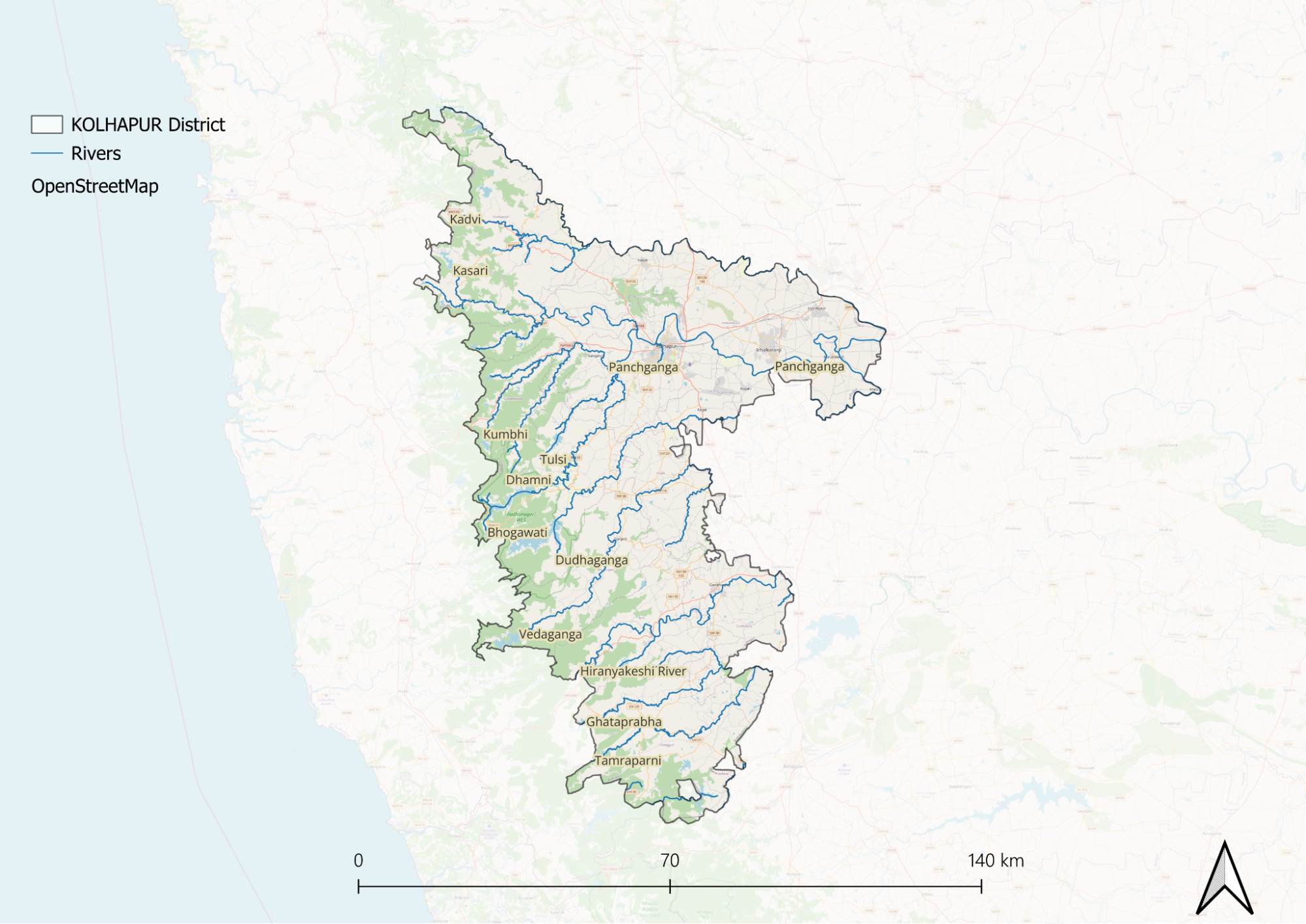
The district is bordered by three principal rivers: the Pranitha River to the west, the southwest-to-south flowing Godavari, and the southeast-bound Indravati River. The western boundary, extending for a distance of 225 km, is formed by the flow of the Wainganga River, which divides the Chandrapur and Gadchiroli districts. Further downstream, the Wainganga River joins the Wardha River in Chandrapur district, and together they form the Pranhita River, which marks the southwestern boundary of Gadchiroli district for 190 km.
The Dina River, originating from Dina Dam near Regadi village, is the main tributary of the Pranitha River, joining it near Rampur Chak village. Near Sironcha, the Pranitha merges with the Godavari and adopts its name. The volume of these combined rivers is further increased by the influx of the Indravati. The Indravati rises in the highlands of Tohamal in the Eastern Ghats and enters this district east of Aheri village. Initially flowing due west, it later turns south and eventually joins the Godavari after a total course of about 275 miles.
Before its confluence with the Indravati, its tributaries, the Parlkota River (Nimbra) and Pamulgautam River (Kotari), join near Bhamragad; their confluence point is known as Triveni Sangam. This scenic location is popular for enjoying sunsets, and animals such as aswal and harin are also observed in this area. The entire Gadchiroli district lies within the drainage basin of the Godavari River. At the southwestern boundary near Sironcha, the Godavari enters the district and flows eastward for about 50 km along its southern boundary. After its confluence with the Indravati at the southeastern corner, the Godavari turns south into Andhra Pradesh.
The Panchganga River, an important river in Maharashtra, derives its name from "Panchganga," meaning "Five Rivers." It is formed by the confluence of five rivers that are the Kasari, Kumbhi, Tulsi, Bhogawati, and Saraswati (believed to be an underground stream), at Prayag Sangam, a site of religious significance. Flowing through the Kolhapur district, the river eventually merges with the Krishna River at Narsobawadi. As a major tributary of the Krishna, the Panchganga River plays a crucial role in supporting agriculture, particularly sugarcane cultivation, due to the fertile soil of its valley. Along its banks lie important cities such as Kolhapur, Ichalkaranji, and Kurundvad. However, despite its economic and spiritual significance, the river faces increasing concerns about pollution, raising the need for conservation efforts.
Botany
Timber trees are primarily found in forest areas, including Teak trees located in the Aheri and Allapalli forest regions, known for their high-quality timber. Saj trees also grow in Aheri, Alapalli, and Moharli forests. Additionally, Sagwan trees and Bamboo are commonly cultivated by farmers.
Wild Animals
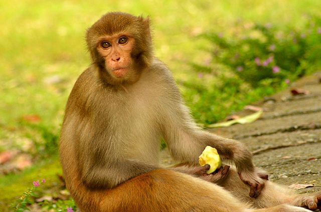
Bandars are restricted to the southern and eastern borders of Sironcha Tehsil along the Godavari and Indravati Rivers. In contrast, Langurs are widely distributed across open areas and forests throughout the district, where they are notorious for damaging crops and fruit trees. In Aheri Village, small herds of Barasingha can be found, raising questions about their local presence. The Mouse Deer is sighted in parts of Aheri and Ghot Villages, while the Barking Deer can be found near the Bhamragad Sangam area. The Chapala Wildlife Sanctuary serves as a haven for various wild animals, including Tigers, Deer, leopards, Wild Cat, Deer, and Sambar.
Forest Reserves
Chaprala Wildlife Sanctuary
The sanctuary is flanked by the Markhanda and Pedigundam hills to the northeast and south, respectively, while the Pranhita River flows along its western boundary. It is located at the confluence of the Wardha and Wainganga rivers. During the monsoon season, river waters swell and enter the sanctuary primarily through numerous nallahs. Along with backwater, a variety of fish, prawns, and turtles also find their way into the sanctuary.
The sanctuary is rich in wildlife, hosting species such as tigers, leopards, jungle cats, bears, wild dogs, deer, sambars, and many other animals. The best time to visit the park is between February and May.
Bhamragarh Wildlife Sanctuary
Bhamragarh Wildlife Sanctuary, located in Maharashtra's Chandrapur district, spans approximately 104 square kilometers within the Sahyadri mountain range. Known for its stunning landscapes and rich biodiversity, the sanctuary features dense forests of deciduous trees, bamboo groves, and grasslands that provide habitats for a variety of wildlife. Visitors can spot tigers, leopards, sloth bears, gaurs, and various deer species. Birdwatchers can enjoy sightings of peafowls, eagles, hornbills, and more.
The sanctuary offers well-marked trekking trails and strategically placed watchtowers for wildlife viewing and photography. It provides a peaceful atmosphere ideal for nature walks, picnics, and cultural explorations of nearby Gond and Madiya tribal villages. The winter months from November to February are recommended for visits due to pleasant weather and optimal wildlife sightings. Basic amenities and knowledgeable guides are available to enhance the experience.
Dajipur Wildlife Sanctuary
Dajipur Wildlife Sanctuary, located on the border of Kolhapur and Sindhudurg districts, is a scenic retreat surrounded by rugged mountains and dense forests. Situated 1,200 meters above sea level, it is home to diverse wildlife, including bison, wild deer, chital, and numerous bird species. The sanctuary, near the backwaters of Radhanagari Dam, offers a peaceful escape for nature lovers and wildlife enthusiasts. An excursion to the nearby Gagangiri Maharaj’s Math adds to the experience, making Dajipur a perfect getaway for those seeking tranquility and adventure.
Land Use
Environmental Concerns
River Pollution
River pollution in Kolhapur district, particularly in the Panchganga River, has become a pressing environmental issue, prompting action from the Maharashtra Pollution Control Board (MPCB). Recently, the MPCB issued a show-cause notice to the Kolhapur Municipal Corporation (KMC) due to its failure to effectively manage and reduce pollution levels in the river. This notice highlights ongoing concerns about mismanagement and negligence by the KMC, which has been criticized for allowing untreated sewage to flow into the Panchganga.
MPCB officials revealed that approximately 46 million liters per day of sewage is being discharged into the river without treatment. Despite previous orders from the National Green Tribunal and directives from local authorities, essential infrastructure such as sewage treatment plants has not been completed. Five out of twelve drains remain unredirected, contributing to the pollution crisis. The situation has reached a point where fish are dying due to the deteriorating water quality, and examinations of sewage samples have shown alarming pollution levels.
The MPCB has a history of taking drastic measures against KMC for similar failures, including cutting off power supply to the municipal headquarters in 2001 and again in 2017. As pollution levels continue to rise and concrete actions remain unimplemented, there are indications that the MPCB may resort to similar measures once more. The ongoing neglect of solid waste management further exacerbates the problem, as waste accumulates in drains and contributes to the overall degradation of water quality in the Panchganga River.
Air Pollution
Kolhapur district is grappling with severe air pollution due to vehicular emissions, poor road conditions, and industrialization. With around 300,000 vehicles operating daily, over one ton of PM10 particulate matter is released into the air, worsened by road dust and factory emissions. As of January 2025, Kolhapur's PM2.5 level stands at 51 µg/m³, while the AQI is 104, categorizing the air quality as "poor," particularly in areas like Dabholkar Corner and Mahadwar Road, whereas the Shivaji University area experiences moderate pollution. Although air quality improves during the monsoon, the Maharashtra Pollution Control Board (MPCB) has issued notices to local authorities for their inadequate response to the worsening pollution levels.
Deforestation
Deforestation in Kolhapur district has become a pressing environmental issue, with significant tree cover loss observed over the years. Between 2002 and 2023, the district lost 54 hectares of humid primary forest, accounting for 17% of the total tree cover lost during this period. Additionally, from 2001 to 2023, approximately 10 hectares of tree cover were lost due to forest fires. A wildlife researcher noted that most deforestation has occurred in the past decade, adversely affecting local climate cycles.
Waste Management
Waste management in Kolhapur district presents significant challenges, primarily due to the increasing volume of solid waste generated. As of January 2025, the city produces approximately 165 metric tons of solid waste daily, a figure that is expected to rise with the growing population and urbanization. The Kolhapur Municipal Corporation (KMC) has implemented a municipal solid waste management system that includes the collection and segregation of waste into dry and wet categories. However, only about 20-30% of the total waste collected is treated, leading to substantial amounts being dumped in open sites.
The existing waste management practices face criticism for their inefficiency and environmental impact. The KMC has initiated public awareness campaigns to encourage residents to segregate their waste properly, but challenges remain in ensuring compliance and effective processing.
Currently, the waste collected is transported to a designated dumping site in Kasaba Bawada, where it undergoes processing to convert biodegradable materials into compost. Despite these efforts, the capacity of existing treatment plants, including those for Refused Derived Fuel (RDF) and Bio-methanation, is insufficient to handle future waste generation trends. As a result, there is an urgent need for improved waste management strategies that incorporate sustainable practices and technologies to address the growing waste crisis in Kolhapur effectively.
Water Scarcity
Kolhapur district is currently grappling with severe water scarcity issues, significantly impacting local agriculture and daily life. Recent reports indicate that nearly 14% of wells in the region, including Kolhapur, Sangli, and Satara, are experiencing declining water levels, as highlighted in the Ground Water Year Book of Maharashtra (2019). Over the past two decades, the average depth of wells has increased from 30 feet to 60 feet, illustrating the growing challenge of accessing groundwater.
In villages like Uchgaon, the situation has become particularly dire. The number of borewells has surged dramatically, from just 15-20 borewells two decades ago to approximately 700-800 today. This rapid increase in borewell installations is driven by the escalating demand for water, which now reaches between 25 to 30 lakh liters daily. However, the village can only supply about 10-12 lakh liters every alternate day, leading to a looming water crisis.
Farmers in Kolhapur are increasingly affected by diminishing groundwater levels, as many rely on wells for irrigation and drinking water. The depletion of this vital resource not only threatens agricultural productivity but also raises concerns about long-term sustainability and community resilience.
Human Wildlife Conflict
In Kolhapur district, human-wildlife conflict has emerged as a significant issue, particularly affecting local farmers and their livelihoods. The increasing interactions between humans and wildlife, especially in agricultural areas, have been aggravated by changing climatic conditions. As climate change impacts the environment, wildlife such as wild boars and deer are increasingly encroaching on farmland in search of food, leading to crop damage and economic losses for farmers.
Farmers have reported substantial losses due to wildlife raids, which not only threaten their immediate food security but also impact their long-term agricultural sustainability. The situation is further complicated by the fact that many farmers rely on livestock for their income. The presence of large predators can lead to livestock losses, creating a cycle of tension between wildlife conservation efforts and agricultural practices.
Efforts to mitigate these conflicts have been limited, with local communities often feeling unsupported in addressing the challenges posed by wildlife.
Conservation efforts/Protests
Rankala Lake Protests
One notable protest occurred at Rankala Lake, where citizens, organized by the Rankala Protection and Conservation Committee, demonstrated against the poor upkeep of the lake's surroundings. On a recent morning, participants wore black ribbons to express their discontent with the Kolhapur Municipal Corporation (KMC) for neglecting the lake despite numerous appeals over the past 40 years. The protesters raised slogans such as "Clean Rankala - Beautiful Rankala," highlighting their demand for action to address pollution and enhance maintenance efforts.
Nagpur-Goa Shaktipeeth Expressway
Farmers in Kolhapur have united under political leadership to protest against the proposed Nagpur-Goa highway project. They argue that the construction of this highway would lead to significant environmental degradation, threatening agricultural land and disrupting local ecosystems.
Panchganga River
In recent years, Kolhapur district has witnessed several protests concerning the pollution of the Panchganga River, a vital water source for drinking and agriculture in the region. Activist Dilip Desai raised alarms in October 2024 about severe pollution in the river, attributing it to stormwater runoff that exacerbates the contamination levels. In May 2024, members of the Maharashtra Navnirman Sena (MNS) organized a protest following a mass die-off of fish in the river, highlighting the urgent need for action against industrial and domestic pollution.
Moreover, in February 2024, villagers and environmental activists threatened to escalate their protests after discovering a significant number of dead fish, further underscoring the ecological crisis facing the river. The Panchganga River is plagued by various pollutants, including industrial waste from sugar and textile industries, untreated domestic sewage from Kolhapur and Ichalkaranji, and agricultural runoff. These factors contribute to deteriorating water quality, which poses health risks to local communities and threatens their livelihoods.
Environmental NGOs
Asmita Mahila Vikas Mandal
This organization focuses on empowering women through various initiatives, including environmental awareness and sustainable practices. It aims to enhance women's roles in community development and promote their participation in environmental conservation efforts.
Action For Human Rights
This NGO is dedicated to advocating for human rights, including environmental rights. It works to raise awareness about the impact of environmental degradation on marginalized communities and promotes sustainable development practices that protect both people and the environment.
Republican Social Foundation
This foundation works towards social justice and empowerment, with a focus on environmental issues that affect disadvantaged groups. It advocates for policies that promote sustainable development and protect natural resources.
Samrat Charitable Trust Akivat
This trust is involved in various charitable activities, including environmental conservation efforts. It aims to raise awareness about the importance of protecting natural resources and encourages community participation in sustainability initiatives.
Shri Datta Sevabhavi Sanstha Nrusinhwadi
Engaged in various social and environmental initiatives, this organization focuses on rural development and sustainability. It aims to improve living conditions in rural areas while promoting eco-friendly practices among local communities.
Graphs
Water
Climate & Atmosphere
Human Footprint
Sources
Bhilatiya, S., Bhargava, A., Nalawade, P., & Kulkarni, R. 2021. Environmentally Sustainable Municipal Solid Waste Management—A Case Study of Kolhapur, India.International Journal of Earth Sciences Knowledge and Applications,3(2), 117–123.https://dergipark.org.tr/en/download/article…
Bhosale, C. S., Mane, P. R., Salunkhe, J. S., Mothgare, V. M., Sutar, S. S., Manglekar, S. B., Jadhav, A. S., & Raut, P. D. 2023. Ambient air quality monitoring with reference to particulate matter (Pm10) in kolhapur city.Nature Environment and Pollution Technology,22(4), 2029–2037.https://doi.org/10.46488/NEPT.2023.v22i04.028
Chavan, J., Date, A., & Sonavane, S. 2023, July 7. Kolhapur district’s water crisis. People’s Archive of Rural India.https://beta.ruralindiaonline.org/article/ko…
Chimote, M. 2020, November 28.The Deccan Traps, India (Part 1): The story of its genesis. Deposits.https://depositsmag.com/2020/11/28/the-decca…
Environmental Status Report 2015-16. 2016. Kolhapur Municipal Corporation and The Energy and Resources Institute.https://www.teriin.org/sites/default/files/2…
Gupta, S. 2013. Ground Water Information, Kolhapur District, Maharashtra (Central Region Nagpur). Governmnet of India, Ministry of Water Resources, Central Ground Water Board.https://www.cgwb.gov.in/old_website/District…
Hydrogeology of Maharashtra. Water Supply and Sanitation Department, Groundwater Survey and Development Agency; Government of Maharashtra.https://gsda.maharashtra.gov.in/en-hydrogeol…
Jain, S. 2019, July 15. Buffaloed by the climate in Kolhapur. People’s Archive of Rural India.https://beta.ruralindiaonline.org/article/bu…
Kolhapur, Maharashtra, India: Deforestation rates & Statistics. Global Forest Watch.https://www.globalforestwatch.org/country/IN…
MPCB notice to KMC over rising pollution in Panchaganga river. 2023, December 7. The Times of India.https://timesofindia.indiatimes.com/city/kol…
Last updated on 6 November 2025. Help us improve the information on this page by clicking on suggest edits or writing to us.