Contents
- Physical Features
- Climate
- Geology
- Soil
- Minerals
- Rivers
- Botany
- Wild Animals
- Birds
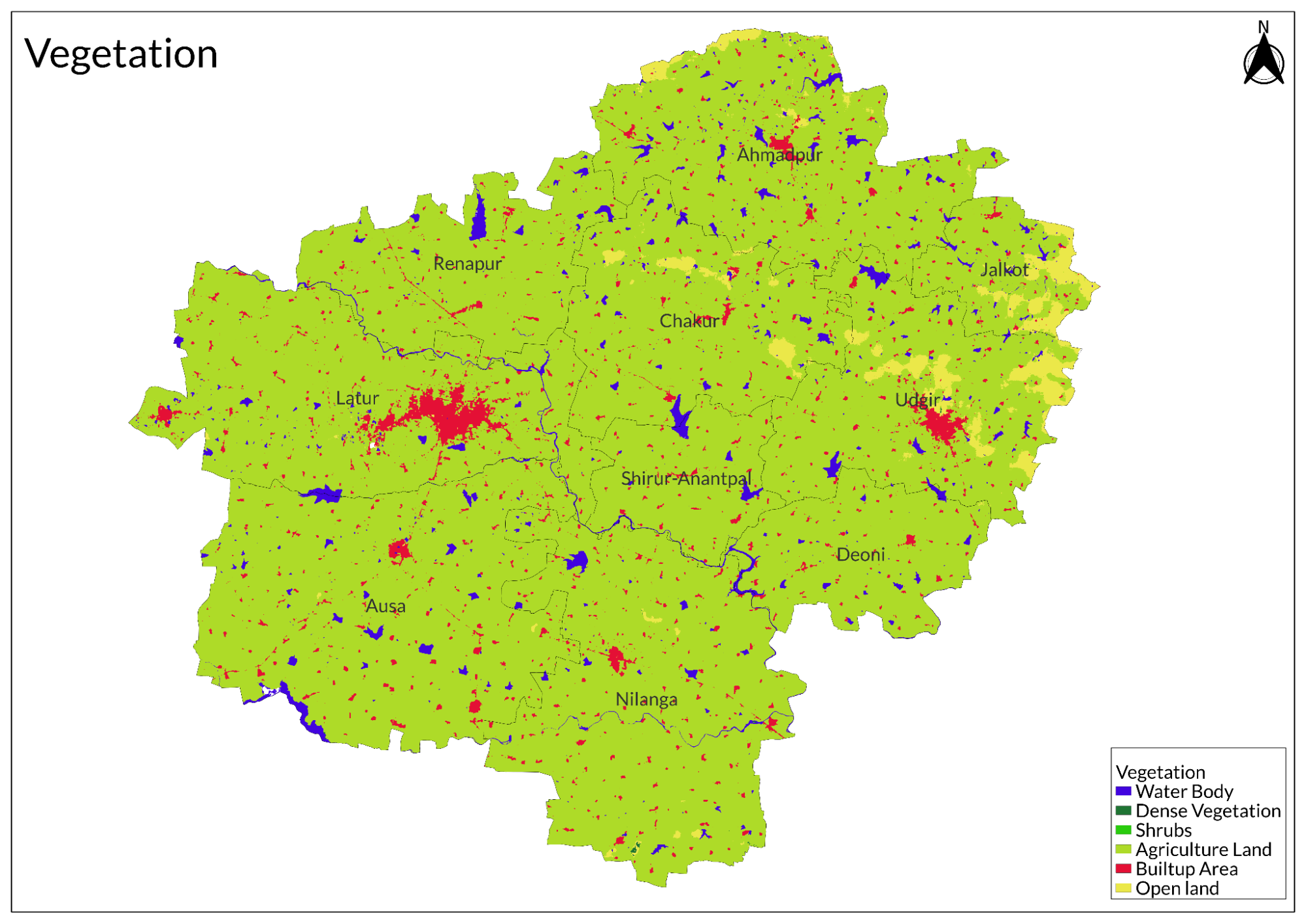
- Land Use
- Environmental Concerns
- Water Scarcity
- Deforestation
- Industrial Pollution
- Climate Change Vulnerability
- Conservation Efforts/Protests
- Jalyukt Shivar Abhiyan
- River Conservation rally
- Handmade Paper Industry
- Graphs
- Water
- A. Rainfall (Yearly)
- B. Rainfall (Monthly)
- C. No. of Rainy Days in the Year (Taluka-wise)
- D. Evapotranspiration Potential vs Actual Numbers (Yearly)
- E. Annual Runoff
- F. Runoff (Monthly)
- G. Water Deficit (Yearly)
- H. Water Deficit (Monthly)
- I. Soil Moisture (Yearly)
- J. Seasonal Groundwater Levels: Bore Wells
- K. Seasonal Groundwater Levels: Dug Wells
- Climate & Atmosphere
- A. Maximum Temperature (Yearly)
- B. Maximum Temperature (Monthly)
- C. Minimum Temperature (Yearly)
- D. Minimum Temperature (Monthly)
- E. Wind Speed (Yearly)
- F. Wind Speed (Monthly)
- G. Relative Humidity
- Forests & Ecology
- A. Forest Area
- B. Forest Area (Filter by Density)
- Human Footprint
- A. Nighttime Lights
- Sources
LATUR
Environment
Last updated on 6 November 2025. Help us improve the information on this page by clicking on suggest edits or writing to us.
Latur, a city situated in the southeastern part of Maharashtra, lies on the Deccan Plateau within the Marathwada region. Defined by its gently undulating topography and deep black cotton soil, the city’s physical landscape has played a crucial role in shaping its agricultural economy and settlement patterns. The region’s land use is shaped by agriculture, urbanization, and conservation efforts, with growing environmental concerns such as water depletion and habitat loss.
Physical Features
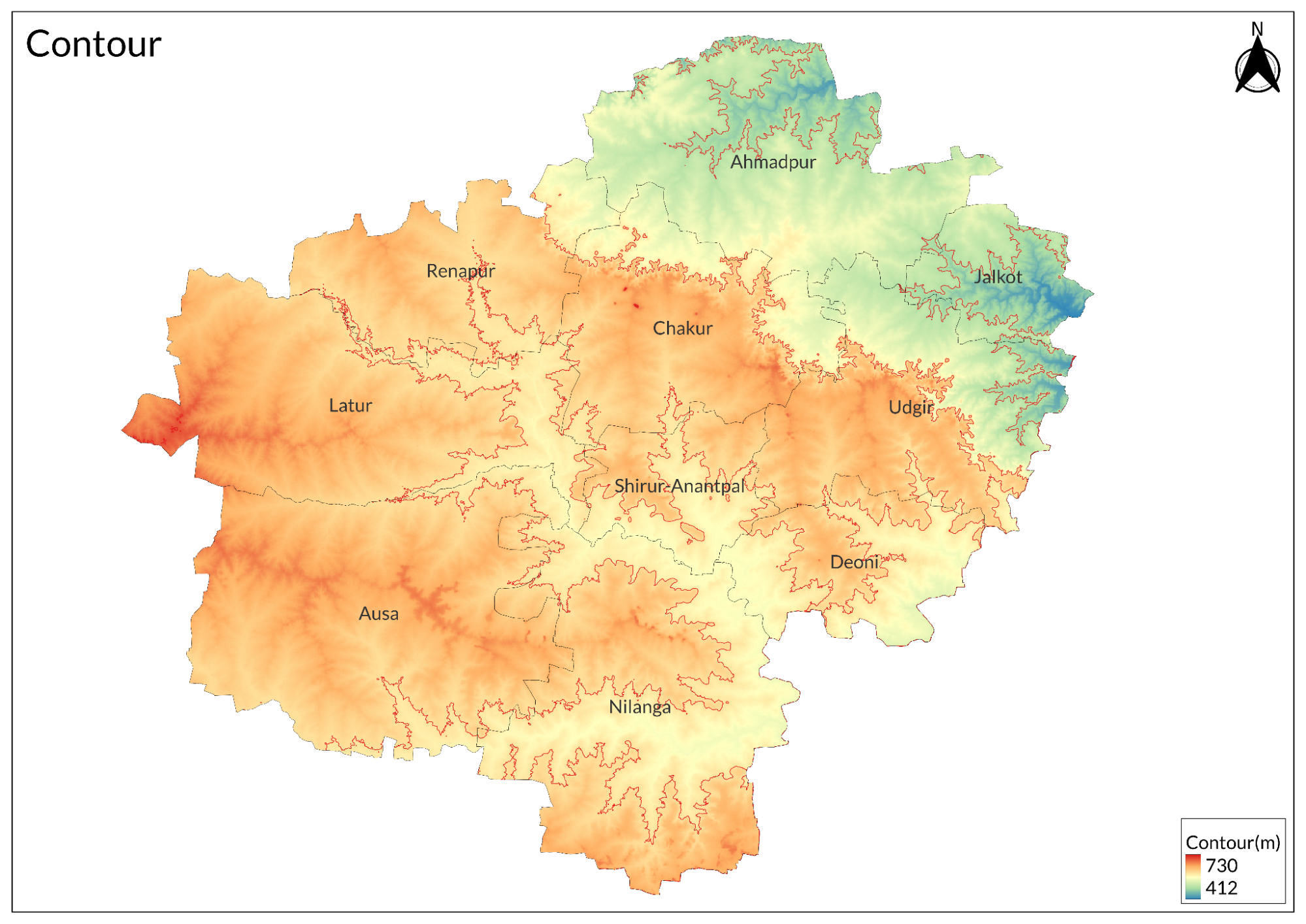
Latur sits on Maharashtra's Deccan Plateau within the Marathwada region, positioned in the southeastern part of the state. The city lies at an elevation of 540 meters above sea level, characterized by its generally flat topography with gentle undulations across the landscape. These undulations create a subtle rolling pattern that is typical of the Deccan Plateau's physiography. The terrain consists primarily of black cotton soil, known locally as regur, which has made the region particularly suitable for growing cotton and soybean crops. This soil type is rich in minerals and has excellent moisture retention properties, making it valuable for agriculture despite the region's semi-arid conditions. The black cotton soil, formed from the weathering of basaltic rocks, can extend to considerable depths and exhibits characteristic shrink-swell behavior with changing moisture conditions. The natural topography has also influenced the city's development pattern, with urban growth following the gentler slopes and avoiding the more pronounced undulations.
Climate
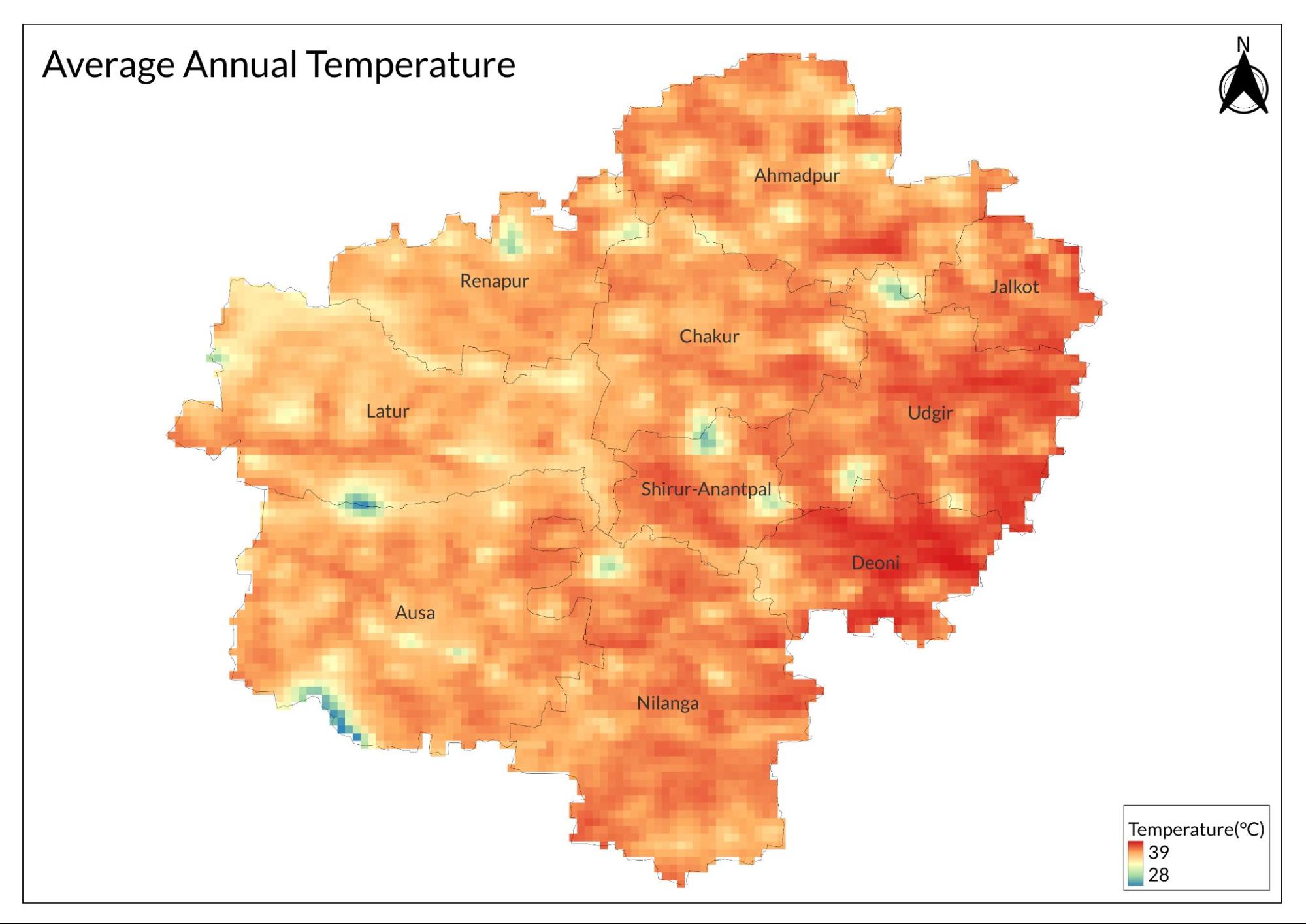
Latur experiences a semi-arid climate with distinct seasonal variations. The summers, spanning from March to June, are hot and dry with temperatures regularly reaching 40°C (104°F). May is typically the hottest month, during which the temperature can occasionally spike to 45°C (113°F). These intense summer conditions are characterized by low humidity and frequent dry winds that sweep across the Deccan Plateau.
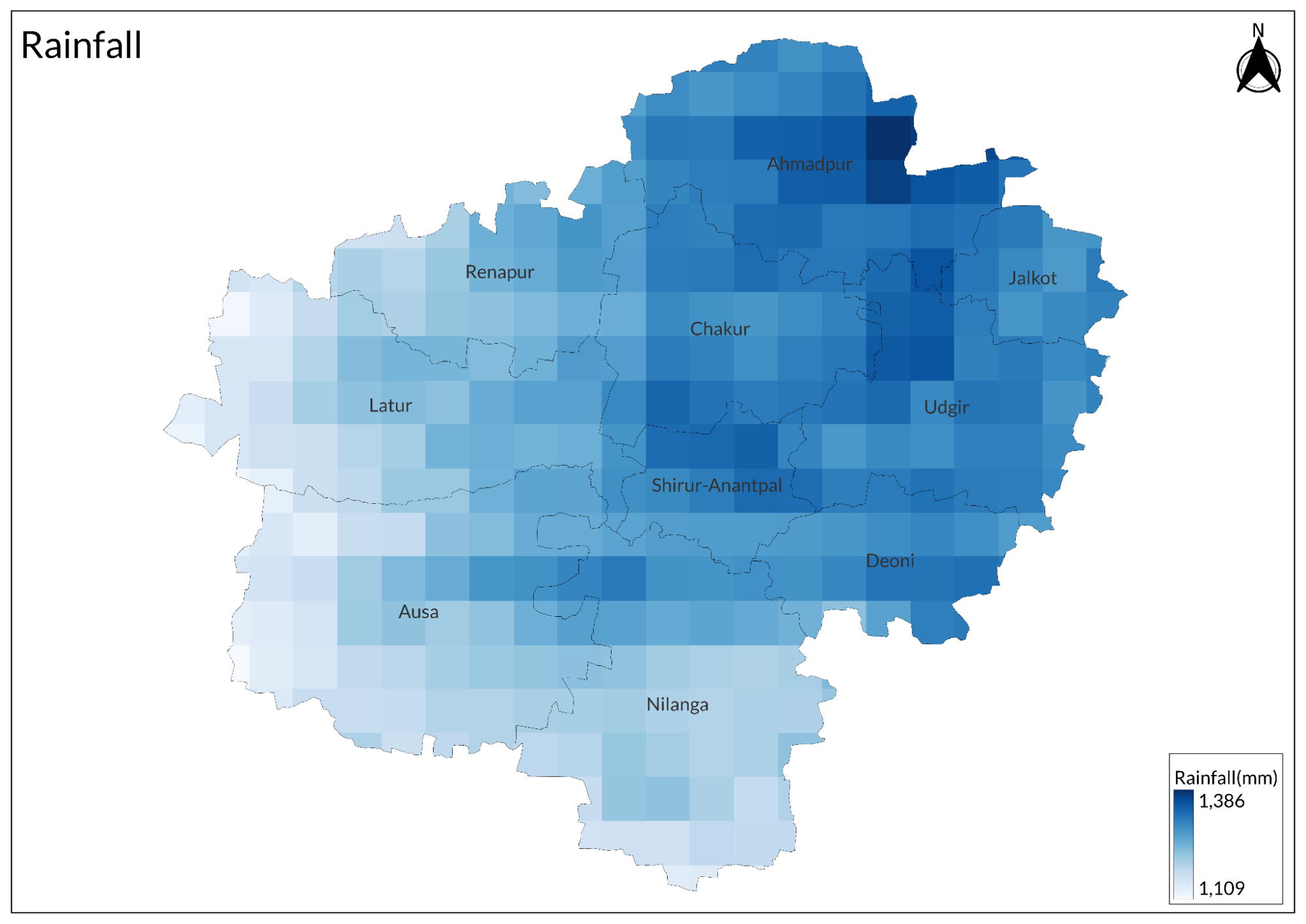
The monsoon season arrives in June and continues until September, bringing moderate rainfall to the region. Latur receives an average annual rainfall of about 600-700 mm, though this can vary significantly from year to year. The rainfall pattern is somewhat irregular, and the region has historically experienced both droughts and occasional flooding during particularly heavy monsoons.
The winter season extends from November to February and is generally mild and pleasant. The temperatures during this period range from 10°C to 25°C (50°F to 77°F). December and January are the coldest months, occasionally experiencing temperatures as low as 8°C (46°F). Winter mornings often feature mist and fog, though these typically clear by mid-morning.
The transitional periods between seasons, particularly October-November and February-March, see moderate temperatures and variable weather conditions. The region also experiences occasional heat waves during summer months and cold waves during winter, though the latter are less frequent. The climate strongly influences the agricultural patterns of the region, with farmers adapting their cropping schedules to align with these seasonal variations.
Geology
The area is primarily composed of basaltic rock formations that were formed during intense volcanic activity approximately 65 million years ago. These basaltic layers, typical of the Deccan Plateau, extend to considerable depths and influence the region's topography and soil composition.
The area sits atop several geological fault lines, with the Killari fault being particularly significant. This fault system became notably active during the devastating 1993 earthquake that measured 6.3 on the Richter scale. The seismic activity revealed the presence of deep-seated geological structures that had remained dormant for long periods.
Soil
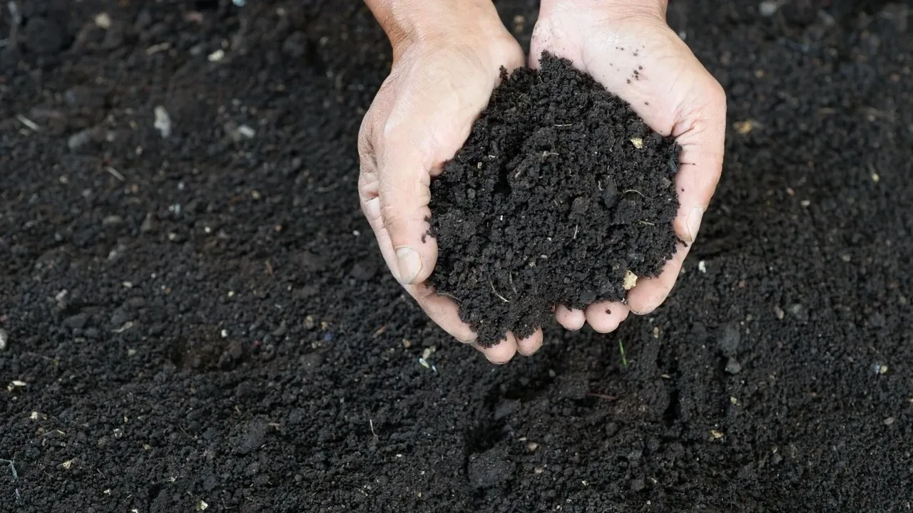
The soil profile typically shows distinct layers, with the upper layers being more weathered and fertile, while deeper layers retain more of the original rock characteristics.
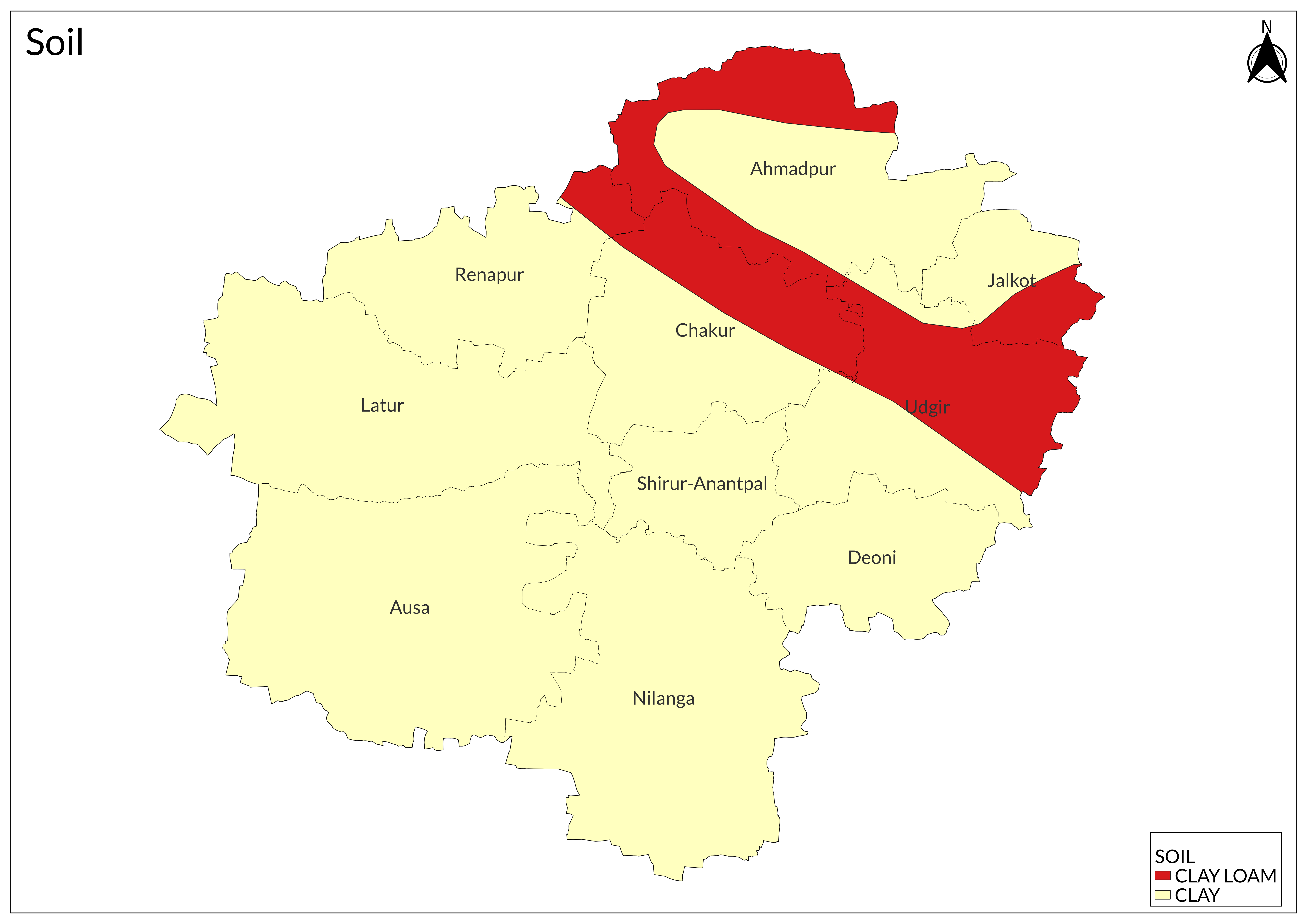
The geological structure also influences the region's groundwater resources. The basaltic rock formations contain numerous joints, fractures, and weathered zones that serve as important aquifers. These geological features create a complex network of groundwater storage and movement pathways, though the water-bearing capacity can vary significantly across different locations.
Minerals
Latur district, being part of the Deccan Trap geological formation, has a limited variety of economically significant minerals. The primary mineral resources found in the region include:
Basalt is the most abundant mineral resource in Latur, occurring as massive flows of the Deccan Trap formation. This igneous rock is extensively used as a building material, particularly for road construction and as aggregate in concrete. The basalt quarries scattered throughout the district provide material for local construction needs.
Black soil minerals derived from weathered basalt are rich in montmorillonite clay, calcium carbonate, and magnesium compounds. While not traditionally considered mining resources, these soil minerals are valuable for agricultural purposes and have potential applications in ceramic industries.
Construction minerals like sand and gravel, obtained from river beds and weathered rock formations, form an important part of the local mineral resources. These materials support the construction industry in the region.
Iron-rich minerals occur in some areas as secondary deposits within the weathered basalt. However, these deposits are generally not of commercial mining grade and remain largely unexploited.
The region also contains minor occurrences of zeolites, which form in the vesicular cavities of basalt rocks. These minerals, though present, are not currently extracted on a commercial scale.
Rivers
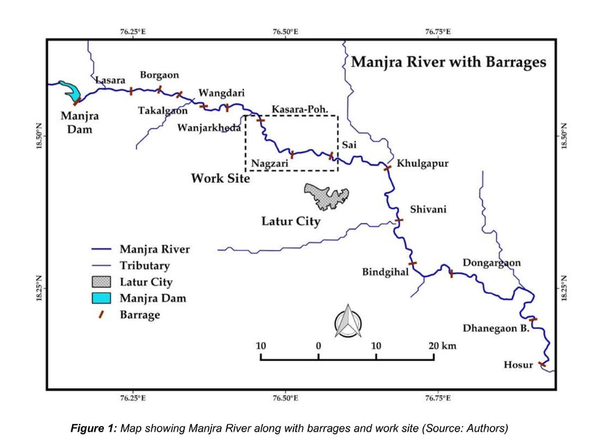
The Tawarja River, a significant tributary of the Manjra, flows through the northern part of Latur district. This river has been dammed to create the Manjra Irrigation Project, which is crucial for the district's agricultural activities. The reservoir formed by this dam is a major source of water for both irrigation and drinking purposes in Latur city and surrounding areas.
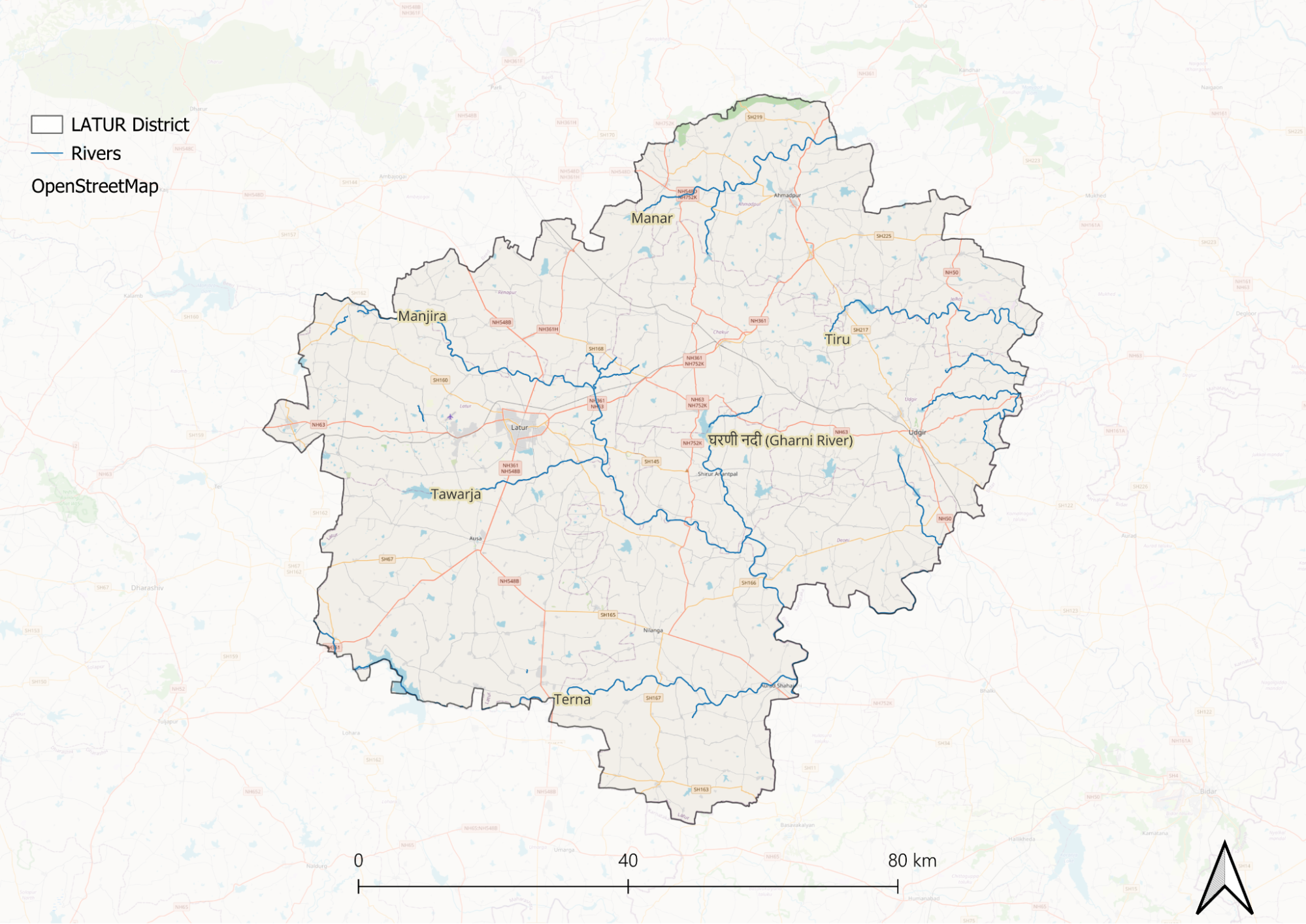
Several smaller streams and seasonal tributaries also crisscross the district, including the Lendi and Rena rivers. These water bodies typically carry substantial flow during the monsoon season but may reduce to a trickle or dry up during summer months. The seasonal nature of these water courses reflects the region's semi-arid climate and irregular rainfall patterns.
The river system in Latur faces significant challenges due to irregular rainfall patterns and increasing water demands. This has led to the implementation of various water conservation projects and the construction of check dams along these rivers to improve water availability throughout the year.
The floodplains of these rivers, particularly the Manjra, have influenced local agricultural practices and settlement patterns, with fertile soil deposits supporting intensive agriculture in areas adjacent to the river courses.
Botany
The natural vegetation consists primarily of deciduous species that can withstand the region's distinct seasonal variations.
The dominant tree species found in Latur include Neem, Babul, Peepal, and Banyan. These trees are particularly well-adapted to the local climate and soil conditions. The Neem and Babul trees are especially common, forming an important part of both urban and rural landscapes.
Medicinal plants form a significant component of the local flora. Species like Adulsa, Nirgudi, and various species of Cassia are found throughout the region. These plants have traditionally been used in local healthcare practices and continue to be important for their therapeutic properties.
Agricultural botany plays a crucial role in the region, with major crops including cotton, soybean, and various pulses. The black cotton soil particularly supports these crops, which have become integral to the local agricultural economy. Jowar and other drought-resistant cereals are also commonly cultivated.
The scrub vegetation, characteristic of the region, includes thorny bushes and small trees that have adapted to survive in the semi-arid conditions. These plants typically exhibit xerophytic adaptations such as small leaves, deep root systems, and other water-conservation features.
Seasonal herbaceous plants emerge during the monsoon period, creating temporary grasslands and providing fodder for livestock. These include various species of grasses and small flowering plants that complete their life cycles during the brief wet season.
Wild Animals
The Indian Grey Wolf and Indian Fox are found in the remote areas, while Jackals are more common throughout the region. Black-naped Hare, Wild Boar, and various species of rodents form the smaller mammal population. The Striped Hyena occasionally visits from neighboring areas.
Indian Palm Squirrel, Indian Grey Mongoose, and Indian Flying Fox are regularly spotted in both rural and semi-urban areas.
Various species of bats inhabit old structures and caves. The Jungle Cat and Rusty-spotted Cat represent the wild feline species in the region, often seen in agricultural fields and shrubland areas. Small Indian Civet and Common Palm Civet are nocturnal inhabitants of the area.
The district's remaining patches of natural habitat also support populations of Indian Antelope or Blackbuck, though their numbers have declined significantly over the years due to habitat loss and fragmentation.
Birds
The Indian Peafowl, being the national bird, is commonly found in the rural and forested areas of Latur. Grey Partridge and Indian Jungle Quail inhabit the grasslands and agricultural fields. Among the raptors, Black Kite, Brahminy Kite, and Indian Spotted Eagle are frequently seen. The Short-toed Snake Eagle and Shikra hunt in open areas. Egyptian Vultures are occasionally spotted, though their numbers have declined significantly.
Common urban birds include House Sparrows, Common Mynas, Rock Pigeons, and Asian Koels. The Indian Roller, Green Bee-eater, and Hoopoe add color to the landscape.
Water bodies, particularly around the Manjra dam, attract seasonal migratory birds including various species of ducks, herons, and waders. The Little Cormorant, White-breasted Waterhen, and Common Moorhen are regular residents near water bodies.
The agricultural landscape supports populations of Red-wattled Lapwing, Indian Robin, and Baya Weaver. Common Babblers and Yellow-eyed Babblers are often seen in scrub vegetation.
Land Use
Environmental Concerns
Water Scarcity
Latur district in Maharashtra faces a severe water crisis due to its semi-arid climate, limited surface water availability, and unsustainable groundwater extraction. With only 10% of agricultural land irrigated by surface water, the district relies heavily on groundwater and inter-district sources. However, frequent droughts, erratic rainfall, and the cultivation of water-intensive crops like sugarcane over 33,000 hectares have led to rapid depletion. The region's black cotton soil and an average annual rainfall of 769.7 mm offer little relief, as reservoirs like Dhanegaon Dam often fail to fill due to upstream diversions. In drought years, declining surface water levels force excessive borewell drilling, yielding saline water that degrades soil quality and reduces agricultural productivity.
The crisis extends beyond rural areas, with urban centers like Latur city struggling with acute shortages due to competing agricultural, industrial, and domestic demands. Borewells frequently run dry, leaving residents dependent on expensive and unreliable tanker supplies. Water scarcity severely impacts farmers, leading to crop failures, economic losses, and food insecurity, while declining groundwater quality—marked by high salinity and nitrate contamination—poses risks to both drinking water and agriculture. Additionally, inter-regional conflicts over dwindling water resources continue to escalate, exacerbating social and economic distress across the district.
Deforestation
Between 2000 and 2020, the district experienced a 9.1% decrease in tree cover. This loss of forest cover disrupts the water cycle, leading to diminished rainfall and heightened drought conditions, thus having severe implications for agriculture and water supplies in the region. Deforestation not only contributes to droughts but also results in biodiversity loss, affecting various plant and animal species that rely on forest habitats.
Moreover, the rising heat levels associated with deforestation further complicate the ecological balance in Latur.
Industrial Pollution
Latur district is among Maharashtra's most polluted areas, primarily due to emissions from its sugar industries and a chemical plant. The Maharashtra Pollution Control Board (MPCB) has rated most local industries poorly, awarding them only 1 or 2 stars on its online portal developed with EPIC-India. Latur is also listed among the state's 17 most polluted cities by the Central Pollution Control Board (CPCB). Air quality expert Geetanjali Kaushik stresses the need for stricter monitoring, while EPIC’s Anant Sudarshan highlights the star-rating program’s role in encouraging cleaner practices. Besides industrial pollution, Latur's dry weather, low vegetation, and groundwater depletion worsen air quality. Experts recommend afforestation and industrial upgrades as key measures to curb pollution and improve environmental conditions.
Climate Change Vulnerability
Latur district is among Maharashtra's most polluted areas, primarily due to emissions from its sugar industries and a chemical plant. The Maharashtra Pollution Control Board (MPCB) has rated most local industries poorly, awarding them only 1 or 2 stars on its online portal developed with EPIC-India. Latur is also listed among the state's 17 most polluted cities by the Central Pollution Control Board (CPCB). Air quality expert Geetanjali Kaushik stresses the need for stricter monitoring, while EPIC’s Anant Sudarshan highlights the star-rating program’s role in encouraging cleaner practices. Besides industrial pollution, Latur's dry weather, low vegetation, and groundwater depletion worsen air quality. Experts recommend afforestation and industrial upgrades as key measures to curb pollution and improve environmental conditions.
Conservation Efforts/Protests
Jalyukt Shivar Abhiyan
The Jalyukta Shivar initiative, launched in December 2014 in Maharashtra, aimed to combat the severe water scarcity faced by many drought-prone villages in the state. This flagship water conservation project was introduced following consecutive years of drought and sought to enhance water resources through systematic measures. The program targeted approximately 25,000 villages, focusing on strengthening existing water bodies like canals and ponds and implementing strategies to capture rainwater during the monsoon season.
Despite its ambitious goals, the Jalyukta Shivar project has recently been scrapped by the Maha Vikas Aghadi government due to concerns over substandard work and allegations of corruption. While the previous administration claimed that the initiative had transformed around 16,000 villages and improved irrigation coverage significantly, critics pointed out discrepancies in project implementation and fund allocation.
River Conservation rally
A river conservation rally was recently held in Latur, Maharashtra, featuring noted conservationist Rajendra Singh. The event aimed to raise awareness about the importance of preserving local rivers and water bodies, which are crucial for maintaining ecological balance and supporting agriculture in the region. Singh, known for his work in water conservation and sustainable practices, emphasized the need for community involvement in conservation efforts.
Participants at the rally discussed the challenges faced by rivers in Latur, including pollution and encroachment, which threaten the health of these vital ecosystems. The rally served as a platform to mobilize local communities and encourage collective action towards protecting and rejuvenating river systems.
Handmade Paper Industry
The handmade paper industry in Latur has flourished over the past three decades, transforming a region often associated with drought and disaster into a hub of sustainable production. The roots of the handmade paper industry in Maharashtra can be traced back to 1934 when Joseph Cornellius Kumarappa established it in Wardha as part of a broader initiative to develop rural industries. The Khadi Village Industries Board later took over and expanded training programs for semi-skilled laborers in handmade paper production.
Kalpakala Industries, a key player in this sector, sources over 400 kilograms of rags from Latur and neighboring cities like Solapur, Bangalore, and Chennai to produce handmade paper, particularly filter paper, which is in high demand from pharmaceutical companies and distilleries. The factory operates efficiently, producing around 360 kg of handmade paper daily while providing employment opportunities for local villagers, including physically challenged individuals and destitute women who are trained in the entire paper-making process. In a region where water scarcity is a significant concern, Kalpakala Industries has implemented effective water management practices. Initially requiring 50,000-60,000 liters of water daily, the unit now operates with just 10,000 liters due to efficient wastewater recycling. This not only conserves water but also saves the company over Rs 3 lakh annually in water costs.
Graphs
Water
Climate & Atmosphere
Forests & Ecology
Human Footprint
Sources
77% of Maharashtra’s cropped area vulnerable to climate change. 2021, August 6. Outlook Business.https://www.outlookbusiness.com//news/77-of-…
Bhat, G., Gowande, A., Shah, K., & Patel, T. 2015, December.Water Conflicts across Regions and Sectors: Case Study of Latur City. TARU Leading Edge Pvt. Ltd.https://www.acccrn.net/sites/default/files/p…
Deulgaonkar, A. 2004, February 15.Handmade paper industry flourishes in Latur. Down To Earth.https://www.downtoearth.org.in/environment/h…
Drought-prone Latur district sees increase in area, shows study. 2022, July 9. The Indian Express.https://indianexpress.com/article/cities/mum…
Latur, Maharashtra, India: Deforestation Rates & Statistics. n.d.. Global Forest Watch.https://www.globalforestwatch.org/country/IN…
Marar, Anjali. 2020, February 25. Explained:Why a mission to make Maharashtra villages drought-free has been shelved. The Indian Express.https://indianexpress.com/article/explained/…
River conservation rally held in Latur; noted conservationist Rajendra Singh takes part. 2023, January 12. ThePrint.https://theprint.in/india/river-conservation…
Sharad, A. 2019, April 16.Latur industries fare poorly in MPCB’s star-rating portal. The Times of India.https://timesofindia.indiatimes.com/city/aur…
Last updated on 6 November 2025. Help us improve the information on this page by clicking on suggest edits or writing to us.