Contents
- Physical Features
- Climate
- Geology
- Soil
- Minerals
- Rivers
- Botany
- Wild Animals
- Birds
- Forest Reserves
- Toranmal Reserve Forest
- Taloda Forests
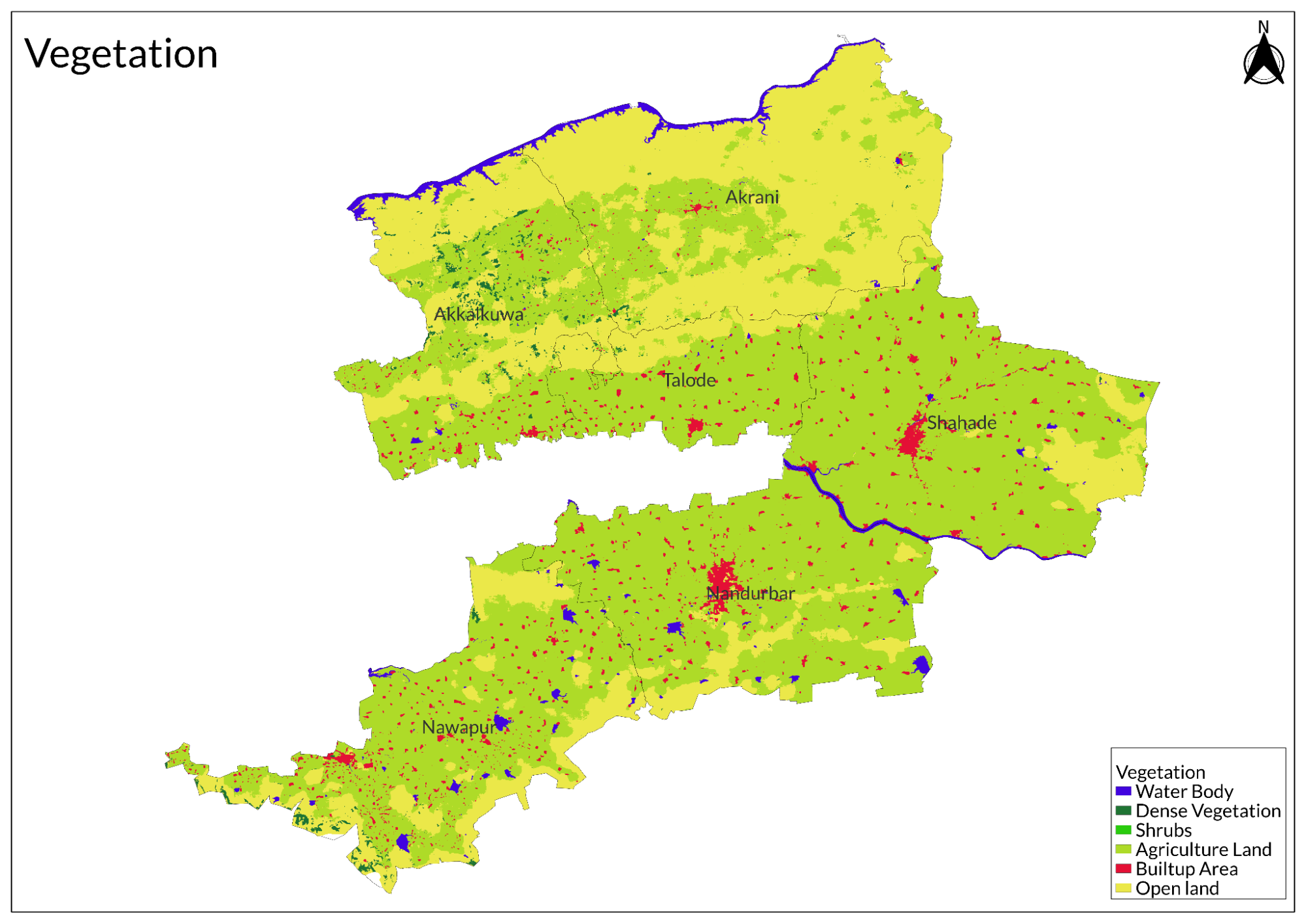
- Land Use
- Environmental Concerns
- Deforestation
- Water Scarcity
- Degradation of Water
- Soil Erosion
- Climate Change Vulnerability
- Environmental NGOs
- Adivasi Mukti Sangathan
- BAIF Development Research Foundation
- Vanvasi Seva Kendra
- Graphs
- Water
- A. Rainfall (Yearly)
- B. Rainfall (Monthly)
- C. No. of Rainy Days in the Year (Taluka-wise)
- D. Evapotranspiration Potential vs Actual Numbers (Yearly)
- E. Annual Runoff
- F. Runoff (Monthly)
- G. Water Deficit (Yearly)
- H. Water Deficit (Monthly)
- I. Soil Moisture (Yearly)
- J. Seasonal Groundwater Levels: Bore Wells
- K. Seasonal Groundwater Levels: Dug Wells
- Climate & Atmosphere
- A. Maximum Temperature (Yearly)
- B. Maximum Temperature (Monthly)
- C. Minimum Temperature (Yearly)
- D. Minimum Temperature (Monthly)
- E. Wind Speed (Yearly)
- F. Wind Speed (Monthly)
- G. Relative Humidity
- Forests & Ecology
- A. Forest Area
- B. Forest Area (Filter by Density)
- Human Footprint
- A. Nighttime Lights
- Sources
NANDURBAR
Environment
Last updated on 6 November 2025. Help us improve the information on this page by clicking on suggest edits or writing to us.
Nandurbar district, situated in the northwestern corner of Maharashtra, is recognized for its varied natural landscape, which includes the Satpura mountain ranges, dense forests, and fertile plains. The region boasts rich biodiversity, with substantial forest cover that supports a wide array of flora and fauna. Key rivers such as the Tapi and Narmada serve as essential resources for agriculture and are crucial to the livelihoods of local communities. Predominantly inhabited by tribal populations, the environment of Nandurbar is closely linked to traditional practices and ways of life. However, with the passage of time, the district is confronting environmental challenges such as water scarcity, deforestation, and soil deterioration; conservation efforts by the locals continue.
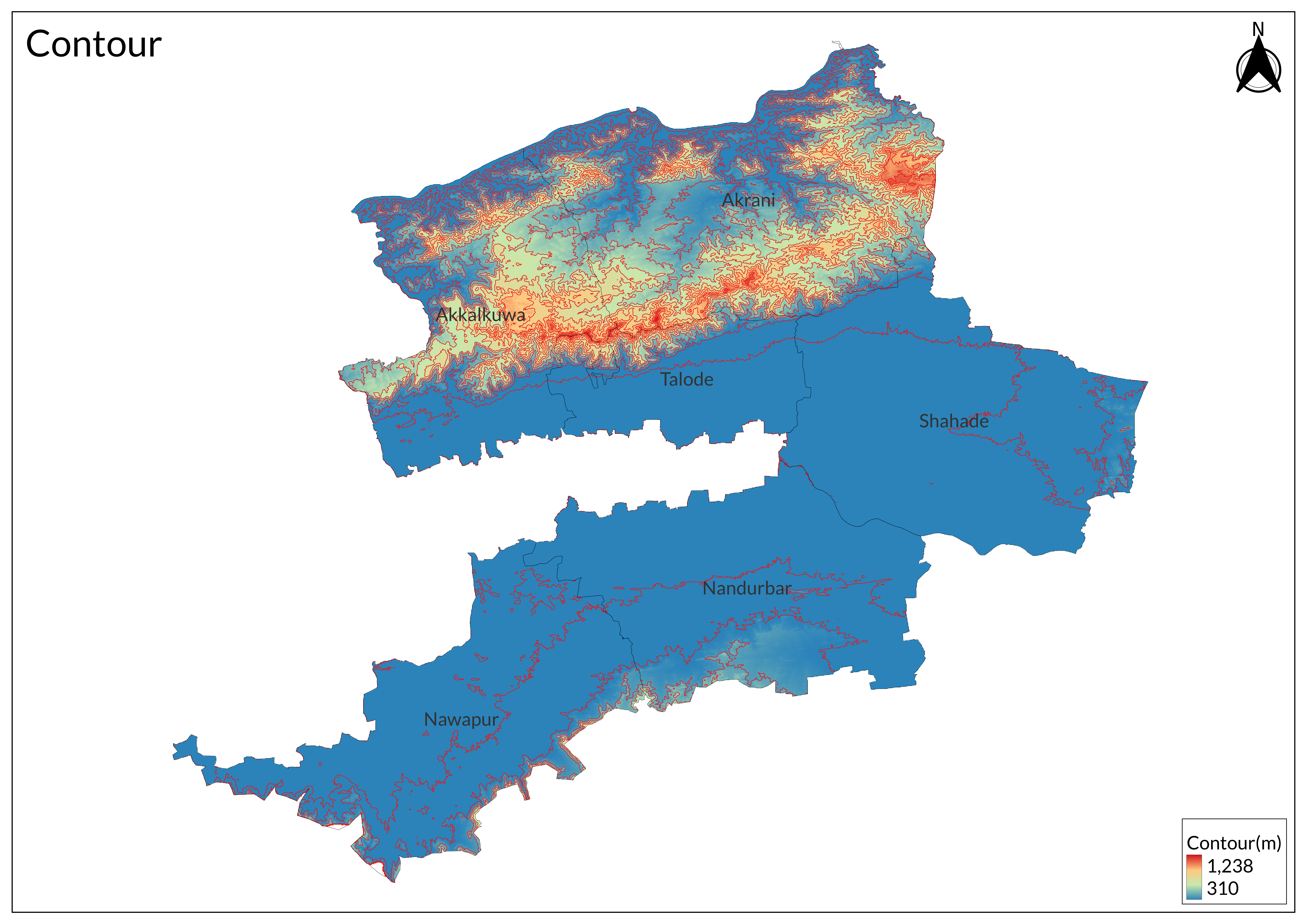
Physical Features
Nandurbar district, formed on 1 July 1998, after bifurcation from Dhule district, is situated in the northwest corner of Maharashtra. The district shares borders with Gujarat in the northwest, Madhya Pradesh in the east, and the Dhule district in the southeast. It encompasses 5,034 sq km and comprises six talukas: Nandurbar, Navapur, Shahada, Taloda, Akrani, and Akkalkuwa. The district headquarters at Nandurbar city is well-connected by road and railway networks, serving a population of 13,11,709 (2001 census).
The district is divided into three distinct physiographic regions: the southern hilly areas of Nandurbar and Navapur taluka, the alluvial deposits around the Tapi river covering Shahada, Taloda, and Akkalkuwa taluka, and the northern part forming the Satpuda range. Notable elevations include the Asthamba peak (1,150 m), the district's highest point, and Toranmal plateau (1,100 m), Maharashtra's second-highest hill station. The plains maintain an average elevation between 550 to 675 meters above mean sea level.
Climate

The climate of Nandurbar District is predominantly hot and dry. Following the general Indian pattern, the district experiences three distinct seasons: summer, monsoon, and winter. Summer extends from March to mid-June, characterized by hot and dry conditions, with temperatures peaking in May at up to 45° Celsius.

The monsoon season commences from mid-June and continues until October. During this period, the weather becomes humid and hot, with the northern and western regions receiving higher rainfall compared to other parts. The district receives an average rainfall of 767 mm. The winter season spans from November to February, featuring mildly cold and dry conditions.
Geology
Nandurbar predominantly lies within the Deccan Basaltic region, with the majority of its area covered by Basaltic flows dating to the Upper Cretaceous period. These formations are extensively intruded by Doleritic and Basaltic dykes. Approximately 30% of the district consists of shallow alluvial deposits from the recent period. A notable geological feature is the intertrappean Lameta bed formation, which is found in Akkalkuwa taluka at the northwestern tip of the district.
Soil

Deep black cotton soil dominates the agricultural areas, known for its water retention properties and agricultural productivity. The central plains feature medium black soil, while the hilly regions contain lateritic soil formations. Along the riverbanks, sandy loam soil is prevalent, offering good drainage characteristics. Some parts of the district also contain red soil, contributing to the area's diverse agricultural potential.
Minerals
Coal deposits are found in specific regions of the district, while building stones are extracted from suitable geological formations. The district also contains deposits of minor minerals, primarily sand and gravel, which support local construction activities. Clay deposits suitable for pottery and other ceramic applications are present in various locations throughout the district.
Rivers
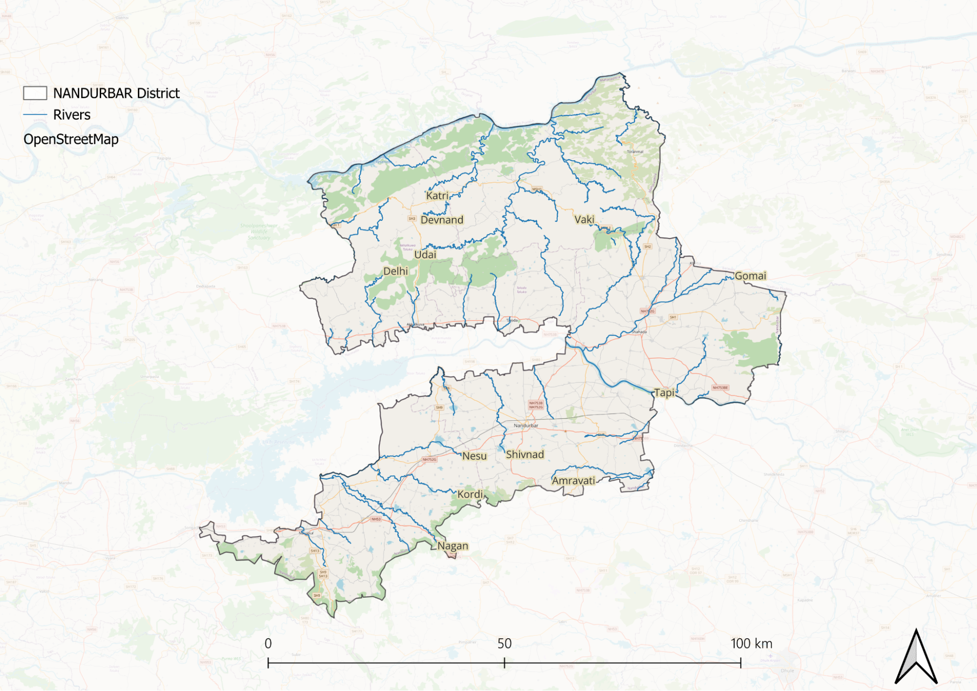
Under the Hydrology Project, the district maintains 11 Piezometers and 60 observation wells distributed in the region. These are monitored quarterly each year for groundwater conditions and hydrological patterns.
Botany
Deciduous forests are characteristic of the Nandurbar district, mainly in the Satpura ranges that make up a large part of the landscape. The forest regions have several native tree species, such as Teak, Ain, Sadada, and Dhavda, that dominate the canopy vegetation. Medicinal plants of ecological and economic importance abound throughout the district.
Valleys and low-lying areas accommodate diverse grass species that feed the local biosphere, as well as serving as a grazing area. In the plains, it is substituted with agricultural areas where many crops are cultivated, depending on the region's soil type, for farming purposes.
Wild Animals

The Indian leopard is the apex predator, playing a vital role in maintaining ecological balance by controlling herbivore populations. Other significant predators include the sloth bear and the Indian wolf.
The herbivorous population features various deer species, such as spotted deer and sambar, along with wild boar. These animals are essential for the ecosystem, serving as prey for larger carnivores and aiding in seed dispersal. Smaller carnivorous mammals like jackals and foxes also contribute to biodiversity and help regulate smaller prey populations.
Birds
Other birds recorded in Nandurbar include several species of ducks such as the Indian Spot-billed Duck, along with many raptors and passerines. The Purna Wildlife Sanctuary within the district also supports a range of avifauna, such as common grey hornbills and woodpeckers.
Forest Reserves
Toranmal Reserve Forest
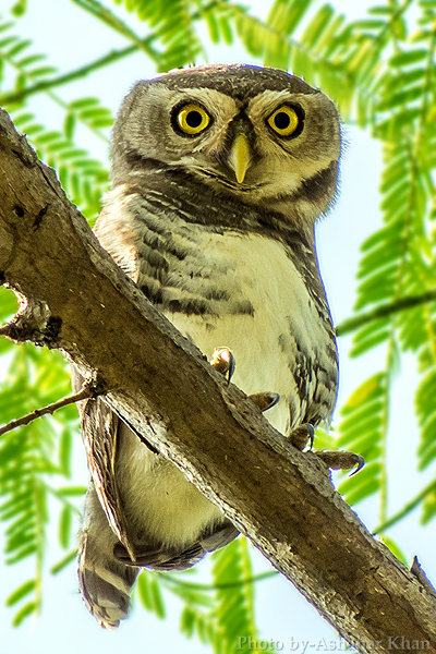
The Toranmal Reserve Forest is one of the most prominent forests in the Nandurbar district. It is located in the Toranmal hill station area, known for its scenic beauty and rich biodiversity. This forest is primarily composed of Southern Dry Deciduous Forest, featuring a mix of teak, bamboo, and various deciduous trees. The reserve is particularly notable for being the habitat of the critically endangered Forest Owlet, which was rediscovered here in 1997 after being thought extinct for over a century. The forest supports a wide variety of wildlife, including several species of birds, mammals, and reptiles, making it a vital area for conservation efforts.
Taloda Forests
The Taloda forests are another important region in Nandurbar district, marked by dense woodlands and hilly topography. These are rich in biodiversity and also provide an important habitat to many species of flora and fauna. There are various tribal communities living in the Taloda region, depending on the forest for their livelihoods, which further adds a cultural dimension to its ecological importance. The forests here are also important to maintain local water cycles and prevent soil erosion.
Land Use
Environmental Concerns
Deforestation
Deforestation in Nandurbar district, Maharashtra, has been driven by various anthropogenic pressures. One significant cause is the conversion of forestland for non-forestry purposes, which leads to the loss of valuable forest cover. This degradation has resulted in habitat loss for numerous species, including the Forest Owlet, which is particularly affected by the diminishing forest areas.
Water Scarcity
Nandurbar district, Maharashtra, faces severe water scarcity due to a rainfall deficit of over 20% in 2021, groundwater depletion of 1-2 meters over the past five years, and extreme weather events linked to climate change. Droughts, floods, increased human consumption, and overuse of water resources have further strained availability. Over-extraction of aquifers and technical issues with solar pumps have exacerbated the crisis, forcing local communities to rely on alternative water sources.
Degradation of Water
Water quality in Nandurbar district, Maharashtra, is impacted by pollution from untreated sewage, industrial effluents, agricultural runoff, and improper waste disposal. Monitoring by the Maharashtra Pollution Control Board indicates high biochemical oxygen demand and low dissolved oxygen levels in many water bodies, signaling organic pollution. Excessive fertilizer and pesticide use contribute to nutrient loading, leading to eutrophication. Groundwater contamination further threatens rural communities that depend on these water sources for drinking and irrigation, while deteriorating water quality affects aquatic ecosystems.
Soil Erosion
Soil erosion in Nandurbar district, Maharashtra, is driven by deforestation, unsustainable land use, and intense rainfall, leading to soil degradation and reduced agricultural productivity. Studies indicate that erosion is most severe along riverbanks and sloped farmlands, where vegetation loss increases runoff. The district's geological features and land management practices influence soil susceptibility to erosion, while climate variability, including heavy rainfall and drought, further exacerbates the issue, impacting crop yields, local ecosystems, and water quality.
Climate Change Vulnerability
Nandurbar district in Maharashtra is particularly vulnerable to climate change, facing a range of challenges including cyclones, floods, droughts, and extreme temperatures. The rising temperatures in the region aggravated this vulnerability and threaten food security for local communities. As a largely agrarian economy, Nandurbar's livelihoods are heavily impacted by these climatic conditions, which disrupt agricultural productivity and threaten the availability of essential resources.
Environmental NGOs
Adivasi Mukti Sangathan
Primarily focused on the empowerment of tribal communities, this organization also addresses environmental issues like deforestation and water resource management in the region.
BAIF Development Research Foundation
Active in Nandurbar and other tribal-dominated areas, BAIF implements programs related to agroforestry, watershed management, and sustainable agriculture.
Vanvasi Seva Kendra
Engaged in promoting sustainable development, this NGO works on preserving the natural environment while supporting tribal livelihoods through eco-friendly practices.
Graphs
Water
Climate & Atmosphere
Forests & Ecology
Human Footprint
Sources
Bhuyar, Dr. A. R., & Ratnaparkhi, V. H. (2024). Geographical study of seasonal variation in water quality parameters of Prakasha barrage on Tapi River in Nandurbar district. International Journal of Geography, Geology and Environment, 6(1), 88–92.https://doi.org/10.22271/27067483.2024.v6.i1…
District - Nandubar. 2025, March 6. Water Supply and Sanitation Department, Groundwater Surveys and Development Agency; Government of Maharashtra.https://gsda.maharashtra.gov.in/district-nan…
Forest Owlet in Human-dominated Landscape of Nandurbar. 2017. Wildlife Research and Conservation Society.https://www.wrcsindia.org/ecologyofforestowl…
Madaan, N. 2022, March 26. 213 villages in Maharashtra may face drinking water crisis in April: GSDA report. The Times of India.https://timesofindia.indiatimes.com/city/pun…
Nandurbar most vulnerable to climate change. 2017, October 11. The Times of India.https://timesofindia.indiatimes.com/city/mum…
Last updated on 6 November 2025. Help us improve the information on this page by clicking on suggest edits or writing to us.