Contents
- Physical Features
- Climate
- Geology
- Soil
- Minerals
- Rivers
- Botany
- Wild Animals
- Birds
- Forest Reserves
- Chandoli National Park
- Sagareshwar Wildlife Sanctuary
- Land Use
- Graphs
- Water
- A. Rainfall (Yearly)
- B. Rainfall (Monthly)
- C. Evapotranspiration Potential vs Actual Numbers (Yearly)
- D. Annual Runoff
- E. Runoff (Monthly)
- F. Water Deficit (Yearly)
- G. Water Deficit (Monthly)
- H. Soil Moisture (Yearly)
- I. Seasonal Groundwater Levels: Bore Wells
- J. Seasonal Groundwater Levels: Dug Wells
- Climate & Atmosphere
- A. Maximum Temperature (Yearly)
- B. Maximum Temperature (Monthly)
- C. Minimum Temperature (Yearly)
- D. Minimum Temperature (Monthly)
- E. Wind Speed (Yearly)
- F. Wind Speed (Monthly)
- G. Relative Humidity
- Human Footprint
- A. Nighttime Lights
SANGLI
Environment
Last updated on 6 November 2025. Help us improve the information on this page by clicking on suggest edits or writing to us.
Physical Features
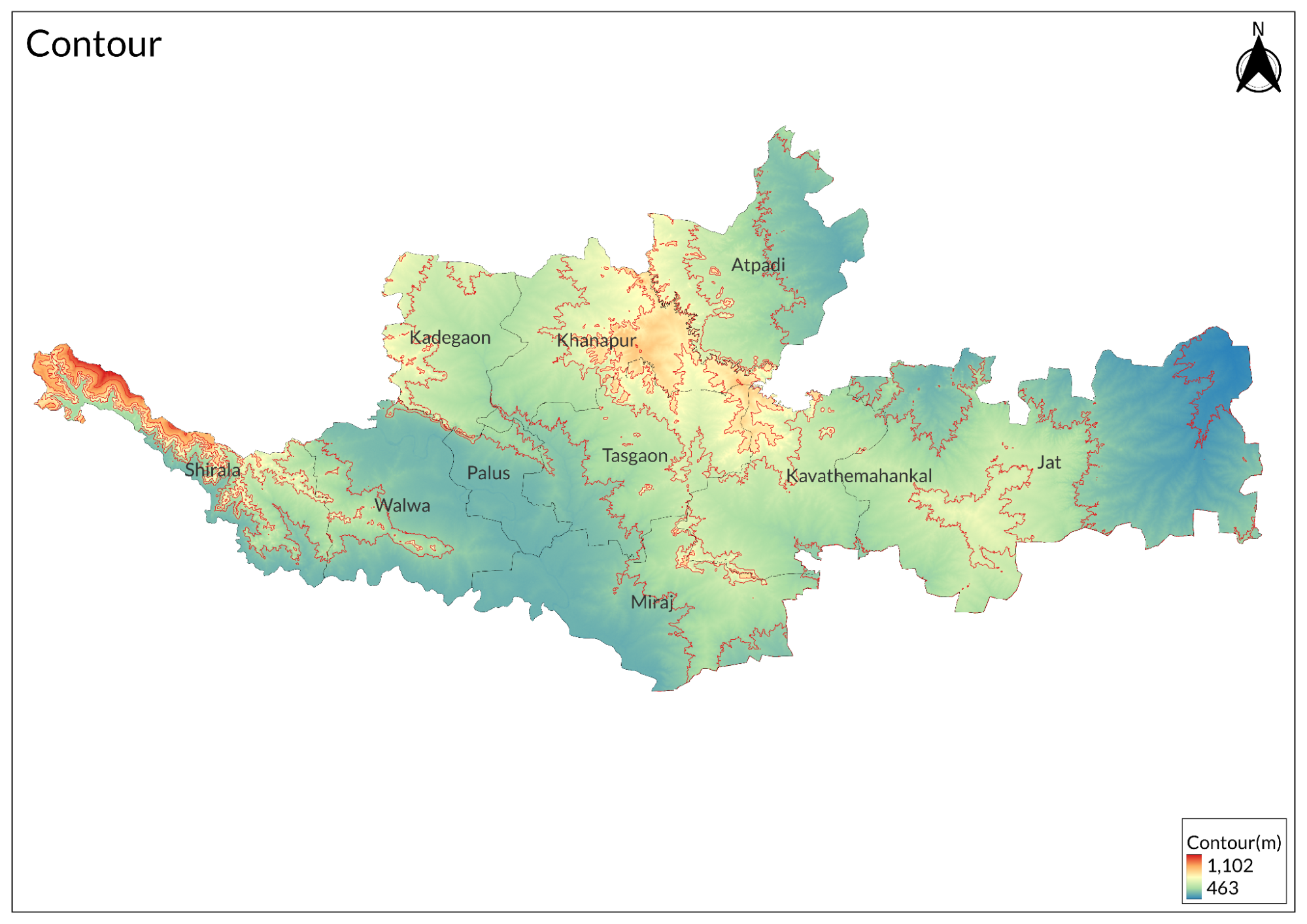
Sangli district is located in the southern part of Maharashtra, India, covering an area of approximately 8,572 square kilometres. It is situated at an elevation of 549 meters above mean sea level and is bordered by several districts: Satara to the north and northeast, Solapur to the north and northeast, Bijapur (Karnataka) to the east, Belgaum (Karnataka) to the south, Kolhapur to the southwest, and Ratnagiri to the west. The western part of Sangli district is characterised by mountainous terrain, particularly in the Shirala tahsil, which is part of the Sahyadri mountain range. The district features diverse landscapes, including hills in Shirala, Khedgaon, and Khanapur tahsils, as well as arid regions in Jat tahsil. The major rivers in the district are the Krishna and Warna, with the Krishna River flowing for about 105 kilometres within its boundaries.
The hills of Sangli can be categorised into several ranges. The Sahyadri rampart, which rises over 4,800 meters, forms the highest hill range. The Bhairavgad-Kandur hills, located mainly in Shirala tahsil, are covered with dense forests and agricultural land. The Machchindragad-Kamal Bhairav dongar range trends northwest to southeast and features steep slopes descending into river basins. The eastern range includes hills like Bhopalgad and Parameshwar, characterised by flat tops and steep descents.
Sangli has a tropical climate with three distinct seasons: hot dry summers from February to June, a monsoon season from June to October, and cool dry winters from November to February. The average annual rainfall ranges from 400 mm to 580 mm, depending on the region within the district. The district is known for its agricultural productivity, primarily due to its fertile soil and irrigation from the Krishna and Warna rivers. It is often referred to as the "sugar bowl of India" due to its extensive sugarcane cultivation. Major crops include ragi and various pulses.
Climate
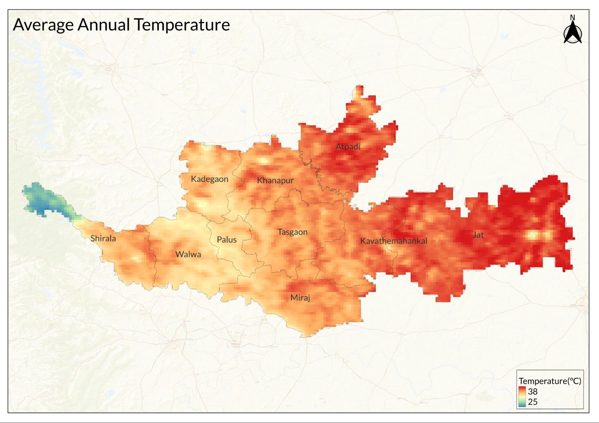
Sangli has a semi-arid climate throughout the year, with average temperatures ranging between 25°C and 31°C. The district experiences a temperature range from a minimum of 14°C to a maximum of 42°C, receiving average annual rainfall between 400 mm and 450 mm. Summer lasts from mid-February to mid-June, starting dry but becoming progressively wetter, characterised by hot days and mild nights.
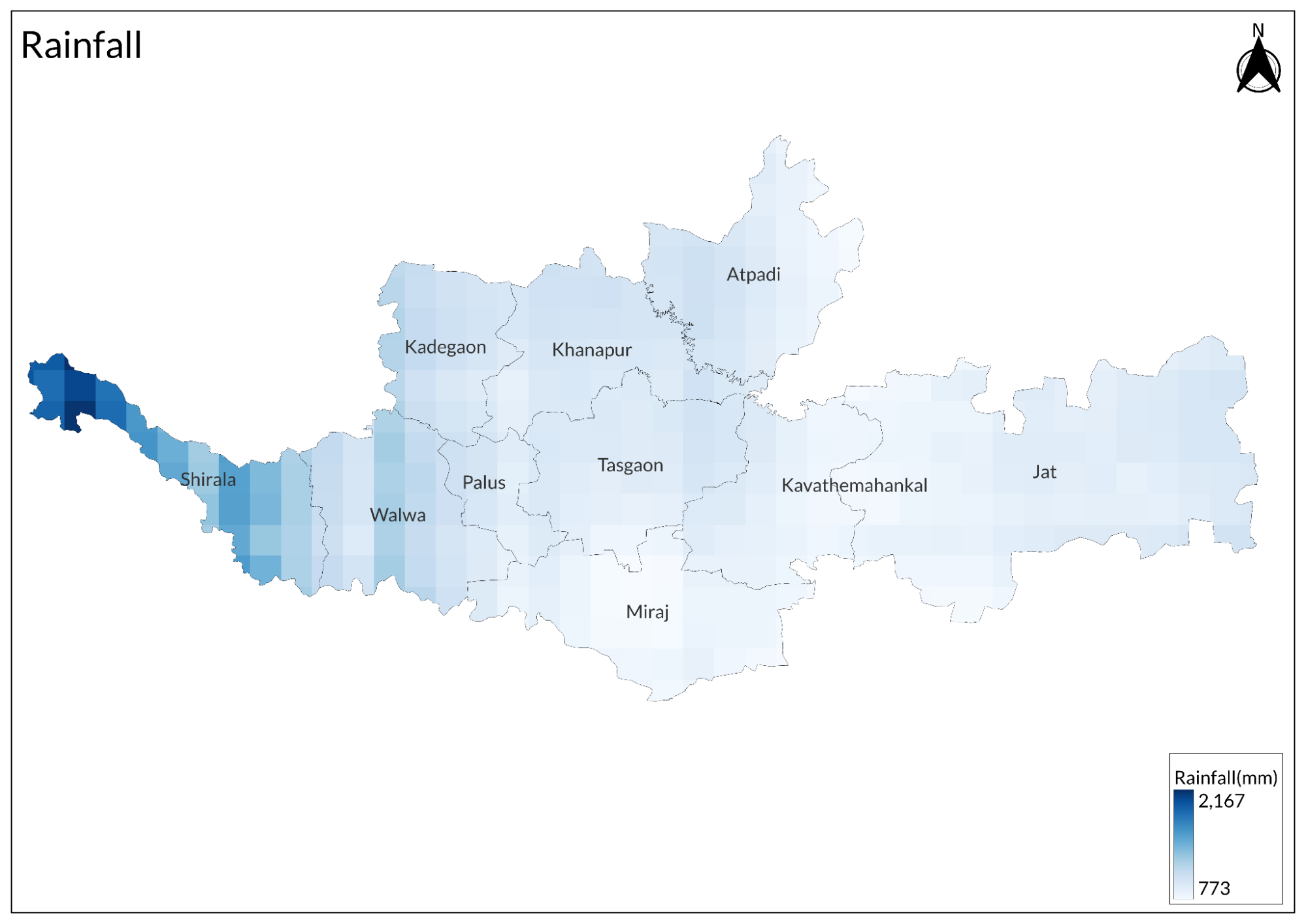
The monsoon season spans from mid-June to late October, bringing the heaviest rainfall of the year along with warm and humid conditions. Winter lasts from early November to early February, typically dry except for some rain in November, featuring warm days and cool nights. The total yearly rainfall averages around 22 inches (approximately 580 mm).
The climate in Sangli is marked by three distinct seasons: a pleasant winter from December to mid-February, a hot summer from mid-February to May, and a rainy season from June to September, with July and August experiencing the most significant rainfall. The region's climate becomes hotter and drier towards the east, while humidity increases towards the west. Overall, Sangli's climate plays a crucial role in shaping its agricultural practices and soil characteristics, influencing both crop productivity and water availability in the area.
Geology
The only geological formation in the district is the Deccan traps from the Cretaceous-Eocene around 145 to 66 million years old.
Soil
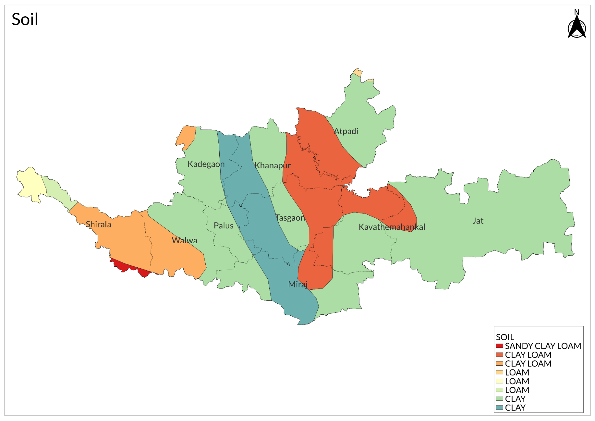
The soil of Sangli district can be classified into several types, including lateritic, red, black, alluvial, and saline-alkaline soils. This classification is influenced by various factors such as climate, rainfall, drainage, characteristics, and the geology of the area. Lateritic soil, which is red in colour, is found in parts of Shirala, Walwa, Miraj, and Jat tahsils; however, this type of soil is generally poor in fertility.
Black soil covers a significant portion of the district and is characterised as clayey to loamy, commonly referred to as black cotton soil. This type of soil is highly fertile and primarily used for agricultural practices. Alluvial soil is mainly transported and found along the banks of the major rivers in the district. Additionally, saline and alkaline soils develop in areas with poor drainage systems and are typically found near Miraj tahsil.
Overall, while the soils vary in quality, they collectively contribute to the agricultural productivity of the district. The black soil is particularly notable for its high fertility and ability to retain moisture, making it suitable for a variety of crops. Proper management practices can enhance the fertility of other soil types like lateritic and red soils, supporting sustainable agricultural development in Sangli.
Minerals
Bauxite ores are the only economically important mineral found in the district. Few building materials are found in the district, including river sand, basalts, and limestones in a very small quantity.
Rivers
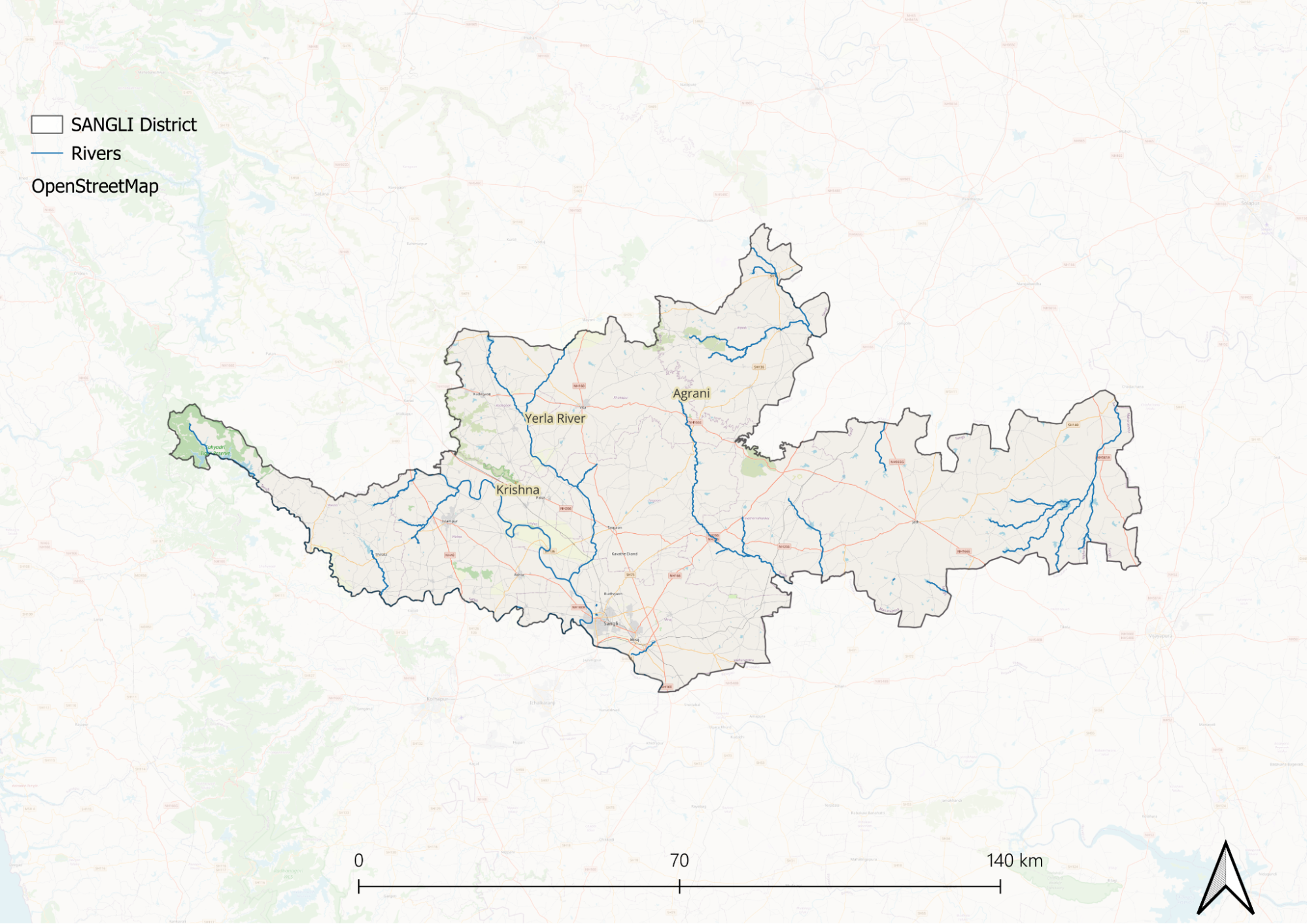
The Krishna River is the major river in Sangli district, although the western part, particularly Shirala tahsil, is associated with the Varna River, while the eastern part falls under the Bhima drainage system. The Varna River originates in the Sahyadri mountains, flowing southward before turning southeast to form the district's southern boundary, eventually joining the Krishna River near Haripur village in Sangli. The Morna River, a tributary of the Varna, rises near Dhamavda hill and flows between the spurs of the mountain range, with villages such as Vakurde Budruk, Antri Khurd, and Mangle located along its banks. East of Shirala village lies Aitawade village, separated by low hills over 300 meters high, where streams flow southward to join the Varna.
The Krishna River itself rises east of the Western Ghats and flows into the Bay of Bengal, traversing a significant portion of India. While it is shorter than the Godavari, it has a larger drainage area due to its two major tributaries, the Bhima and Tungabhadra. Within Sangli district, the Krishna flows for approximately 108 kilometres and is joined by the Varna and Yerla rivers. The Agrani River also contributes to its flow just outside the district. The Krishna valley is known for its fertility, making it suitable for cultivating crops like sugarcane and jowar. Prosperous villages and towns such as Narsingpur, Bahe, Borgaon, Walwa, Nagthane, Burli, Amanapur, Bhilawadi, and Sangli are situated along its high banks.
The Bhima River is recognised as the longest tributary of the Krishna. Near Sangli, three tributaries—Panchganga, Warna, and Yerla- join the Krishna River. These confluences are considered sacred by locals. On the western side of the district, a series of amphitheatres formed by spurs from the Vardhangad-Machchindragad range are drained by small tributary streams of the Yerla basin. Villages such as Shamgaon, Khamble, Apshinge, Nerli, Kotavdi, and Shirasgaon are nestled within these amphitheatres and connected by road tracks.
The Agrani River rises near Balvadi in the Khanapur plateau and flows eastward through a deeply incised valley. Its narrow valley bottoms provide fertile soils with irrigation facilities in otherwise barren plateau areas. The east bank tributaries of the Agrani have carved broader valleys which support more intensive agriculture; consequently, villages are larger and more frequent on this side than on the west. After flowing about 32 kilometres southward, the Agrani turns southeast at Vajrachaunde to join the Krishna River just below Dhulgaon.
The Man River has approximately 16 kilometres of its course within or bordering the Sangli district. It drains the northeastern parts of Khanapur and Miraj tehsil into the Bhima River. Several tributaries drain westward from the Khanapur plateau into it: Satvai, Masira, Bhakar, Gharkada, and Balateda, which is formed by Bhandora, Sikir, and Dabucha streams. Atpadi is an important village situated on the Dabucha River and surrounded on three sides by a loop of water. The Korda River rises just west of Jath tehsil and flows northward to join the Man outside Sangli. The eastern part of Jath tahsil is primarily drained by the Bor River along with its tributaries Dodda and Darai.
Currently, rivers in Sangli district face various challenges, including pollution and irregular water flow due to seasonal changes and upstream damming. The Krishna River remains a primary water source but has been affected by these issues. The Warna River also plays a significant role but suffers from reduced rainfall and water management practices that lead to lower water levels outside the monsoon season. Recent efforts include irrigation projects aimed at improving water availability for agriculture and domestic use.
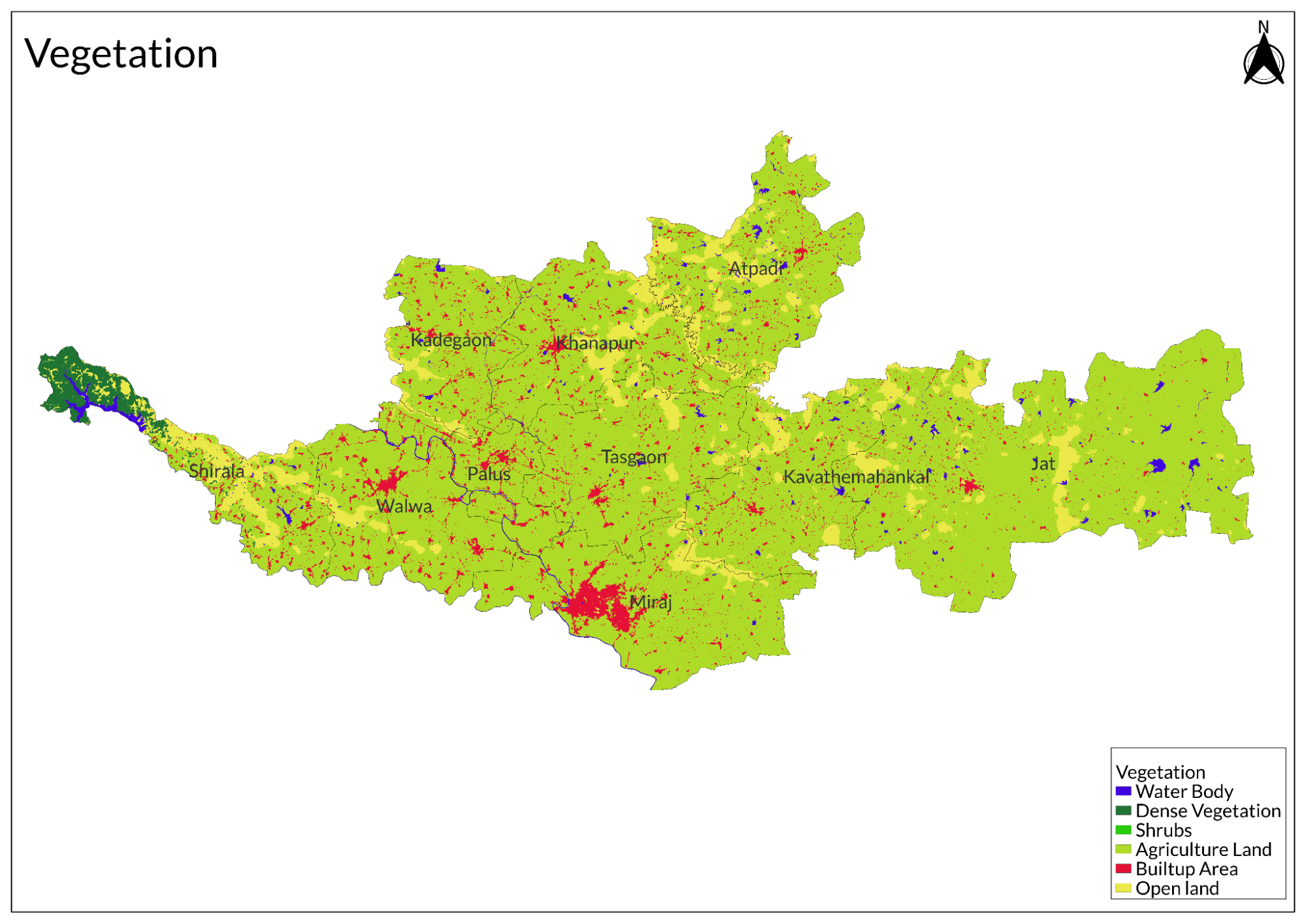
Botany
Sangli's forests can be classified into four distinct groups: evergreen forests on the Sahyadri hills, wet and dry deciduous forests on the slopes of the hills that form the catchment area of the Varna River, forests with bushy and stunted tree growth on the hills east of the Krishna River, and grassy areas with sparse tree growth in Jath. The evergreen forests are primarily found from Chandoli in the north to Bhogir in the south, adjacent to Kolhapur district.
In the Shirala Mahal region, both sides of the Varna River host a variety of tree species, including jambhul, anjani, pisa, phanas, vad, amba, kumbhal, payer, and beheda. Teak, dhavda, ain (Indian laurel), palas, kusum, dhaman, bhava, shiras, and ghatbor are prevalent in the hilly slopes approximately 32 kilometers from the Varna River's source, covering central and eastern parts of Shirala Mahal and eastern Walwa Tehsil. In Atpadi Mahal, which is mostly barren with scattered stunted and bushy growth, species such as murmati, babul, bor, neem, jambhul, chinch (tamarind), and karanj are commonly found.
The sparse tree growth areas include khair and tarwad species that are distributed throughout the district. Notable locations include Birnal, Belunkhi, Kholeshwar, Jirgyal, Sonkh, Waleshkhindi, Vashan, and Khatali in Jath Taluka. The diverse forest types contribute significantly to the ecological balance and biodiversity of Sangli district while supporting various agricultural practices in the region.
Wild Animals
Wildlife in Sangli district is primarily found in the dense forest areas of the western portion of Shirala Mahal. Notable wild animals include bison, panther, sambar, bear, wild boar, hyena, deer, fox, and hare. Bison, bears, and wild boars are typically confined to the semi-evergreen and evergreen forests of the Rundhiv plateau and its slopes. Panthers, sambars, and deer are occasionally spotted in the forests of Bilashi and Charan, while foxes and hares are common throughout the district. These animals often take shelter in fields and along riverbanks.
Bears (Asval) inhabit the dense forests, residing in hollows within rocks or ravines and feeding on roots and fruits from forest trees. Wild boars (Dukkar) are also found in these dense forest areas. Hares (Sasa) and deer thrive in scrub jungles; however, their populations have significantly declined due to excessive hunting by local residents. Sambars can be found within the forests of Bilashi and Charan.
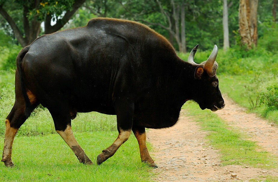
Chandoli National Park, established in 2004 as part of the Sahyadri Tiger Reserve, is a significant habitat for various wildlife species, including tigers, leopards, Indian bison, leopard cats, sloth bears, and giant squirrels. The park supports a diverse ecosystem with numerous prey species such as barking deer and mouse deer. Additionally, Shukacharya Hills within Sangli district provide a rich habitat for various mammals, birds, and reptiles.
Birds
Wildlife in Sangli district has seen a significant decline in wild bird populations due to extensive agricultural activities and a lack of forested areas. Commonly found species include sparrows, peafowls, and jungle fowls, particularly in the forests of Shirala Mahal. Partridges and quails are typically encountered in grassy areas and sheltered spots along nalas throughout the district.
Forest Reserves
Chandoli National Park
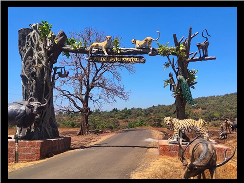
This park is part of the Sahyadri Tiger Reserve and spans about 317.67 sq km. It is home to a variety of wildlife, including tigers, leopards, bison, and several species of birds and reptiles. The park is known for its rich biodiversity and scenic landscapes. It is an excellent spot for bird watching, trekking, jeep safaris, boating, and other wildlife activities in Maharashtra. The best time to visit is between October and February.
Sagareshwar Wildlife Sanctuary
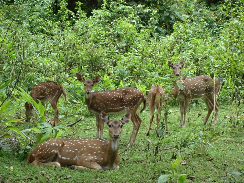
Despite its artificial origins, it has become one of the notable wildlife sanctuaries in the state. The sanctuary hosts abundant wildlife, including wild boars, blackbucks, sambar, and deer, as well as various reptiles, insects, and birds. The sanctuary also has a rich variety of flora. The best time to visit is from August to February.
Land Use
Graphs
Water
Climate & Atmosphere
Human Footprint
Last updated on 6 November 2025. Help us improve the information on this page by clicking on suggest edits or writing to us.