Contents
- Physical Features
- Climate
- Geology
- Soil
- Minerals
- Rivers
- Botany
- Wild Animals
- Fishes
- Snakes
- Forest Reserves
- Tipeshwar Wildlife Sanctuary
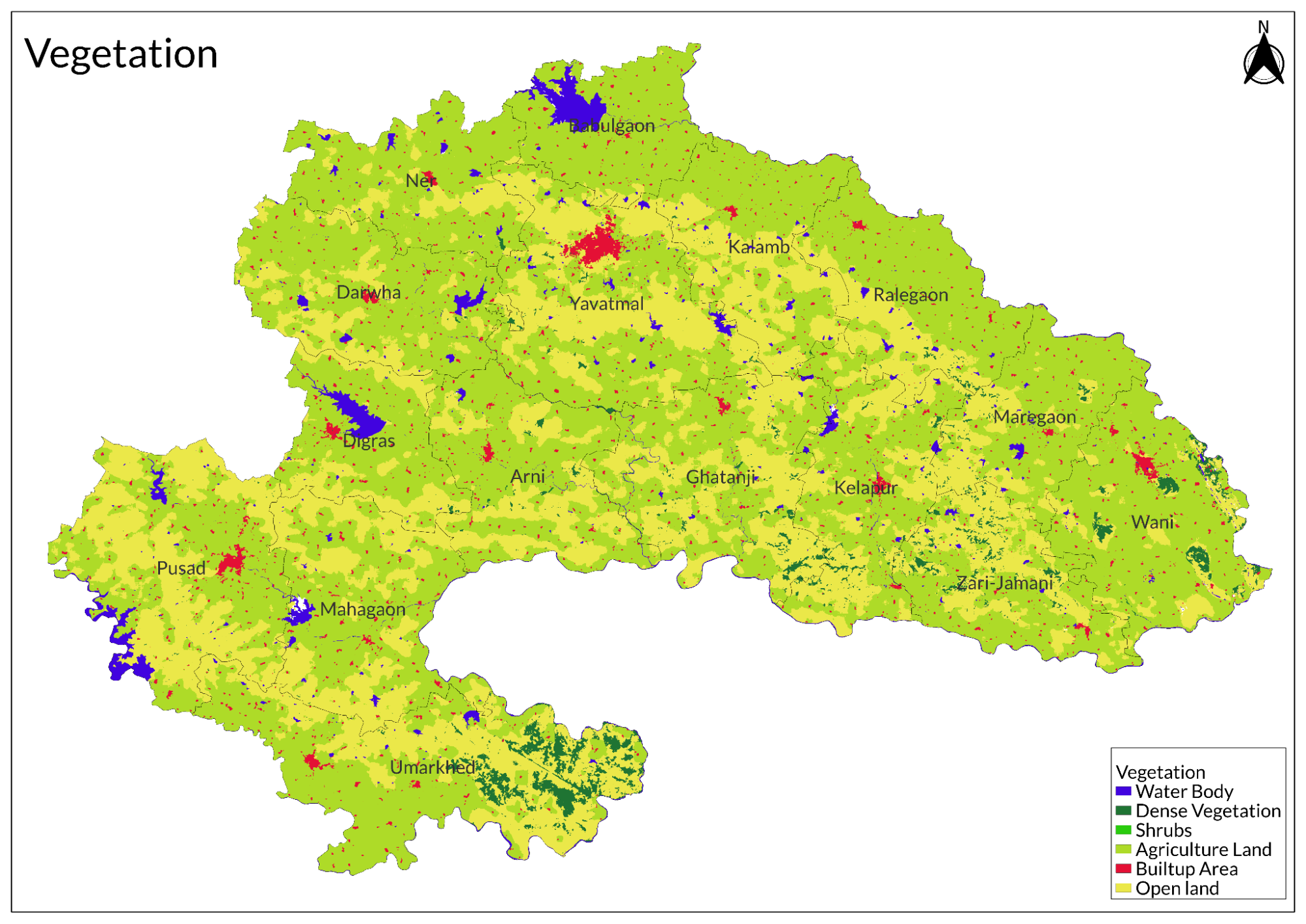
- Land Use
- Environmental Concerns
- Deforestation
- Water Scarcity
- Soil Degradation
- Graphs
- Water
- A. Rainfall (Yearly)
- B. Rainfall (Monthly)
- C. No. of Rainy Days in the Year (Taluka-wise)
- D. Evapotranspiration Potential vs Actual Numbers (Yearly)
- E. Annual Runoff
- F. Runoff (Monthly)
- G. Water Deficit (Yearly)
- H. Water Deficit (Monthly)
- I. Soil Moisture (Yearly)
- J. Seasonal Groundwater Levels: Bore Wells
- K. Seasonal Groundwater Levels: Dug Wells
- Climate & Atmosphere
- A. Maximum Temperature (Yearly)
- B. Maximum Temperature (Monthly)
- C. Minimum Temperature (Yearly)
- D. Minimum Temperature (Monthly)
- E. Wind Speed (Yearly)
- F. Wind Speed (Monthly)
- G. Relative Humidity
- Forests & Ecology
- A. Forest Area
- B. Forest Area (Filter by Density)
- C. Wildlife Projects (Area and Expenses)
- Human Footprint
- A. Nighttime Lights
- Sources
YAVATMAL
Environment
Last updated on 6 November 2025. Help us improve the information on this page by clicking on suggest edits or writing to us.
Yavatmal district in Maharashtra is recognized for its abundant natural resources, which include extensive forests, diverse wildlife, and fertile agricultural lands. A notable feature of the district is the Tipeshwar Wildlife Sanctuary, an essential biodiversity hotspot that plays a crucial role in tiger conservation and supports a wide variety of flora and fauna. However, with the advent of time, the district is also facing environmental concerns.
Physical Features
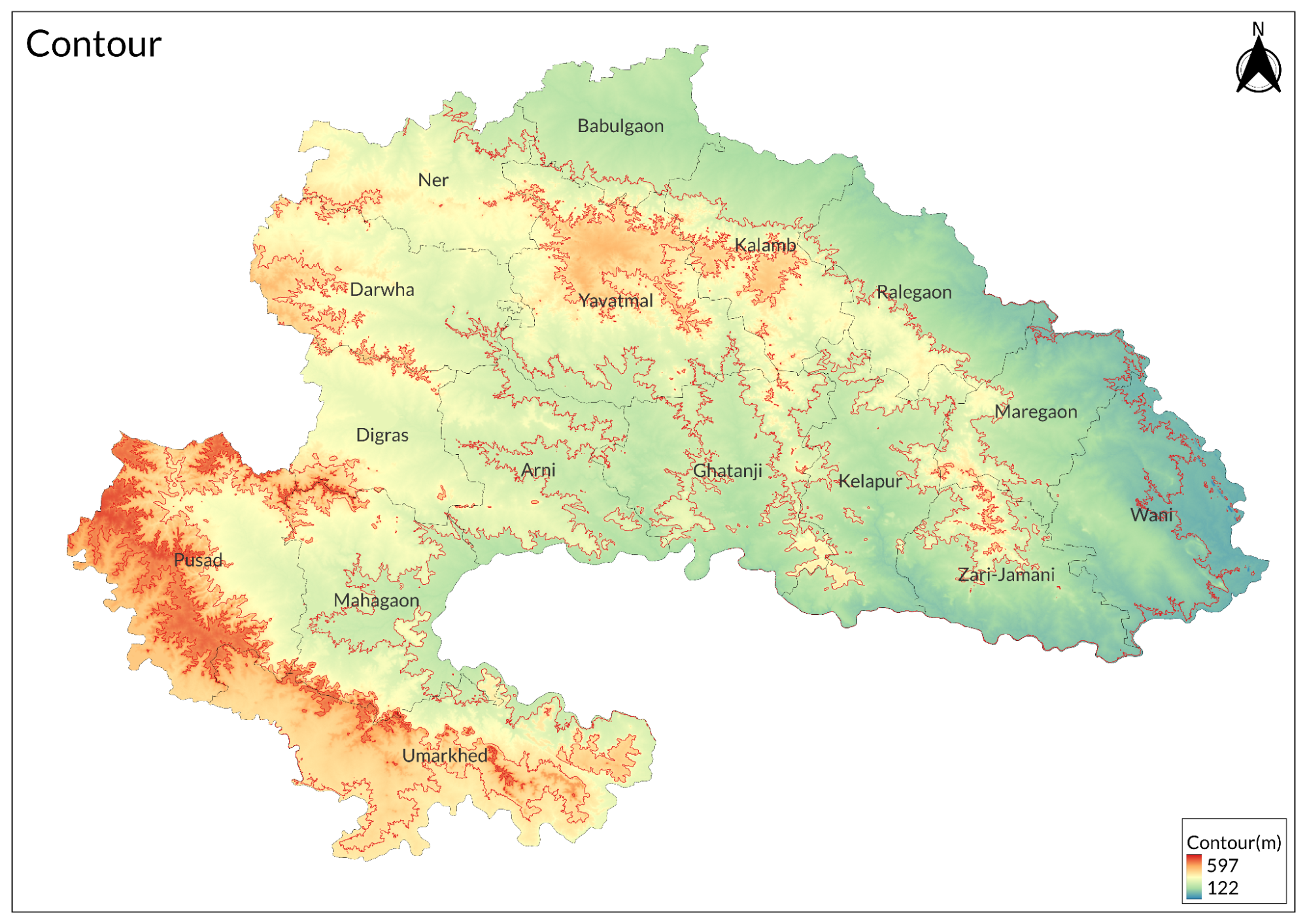
Yavatmal district is located in the eastern part of Maharashtra, India. It is about 445 meters above sea level and covers an area of 13,582 square kilometers. The district is surrounded by Amravati and Wardha to the north, Chandrapur to the east, and Nanded and Telangana to the south. To the west, it borders Washim and Hingoli. Yavatmal is divided into seven subdivisions and sixteen tehsils, which include various talukas. The name "Yavatmal" comes from the Marathi word "Parvatrang," meaning "mountain range." The city of Yavatmal is on hills at an elevation of 450 meters and covers 90 square kilometers. Old records say that the city is safe because it is on hills, making it hard for invaders to attack.
Yavatmal district is part of the southwestern area of the Wardha-Wainganga plain. It has hills and valleys and is partly surrounded by plains. The southern half of Yavatmal taluka features a plateau with steep sides and flat-topped or pointed hills, while the eastern and western parts have rough hill ranges. Some well-known hills in the district are Lalgarhi Hill, Chowsala Hill, Bairambua Hill, and Dattapur Hill.
To the north, Yavatmal extends into the Payanghat valley, which is about 65 to 80 kilometers wide and runs east to west across the area. This valley creates a plain belt about 72 kilometers wide in the northern parts of Yavatmal and Darwha tehsils. The Wardha valley continues this plain along the northern side of Kelapur tehsil and parts of Wani tehsil, stretching over 160 kilometers. Additionally, the Penganga River forms a plain along the southern border of the district, with its tributaries creating valleys several miles wide through the hilly areas.
Climate
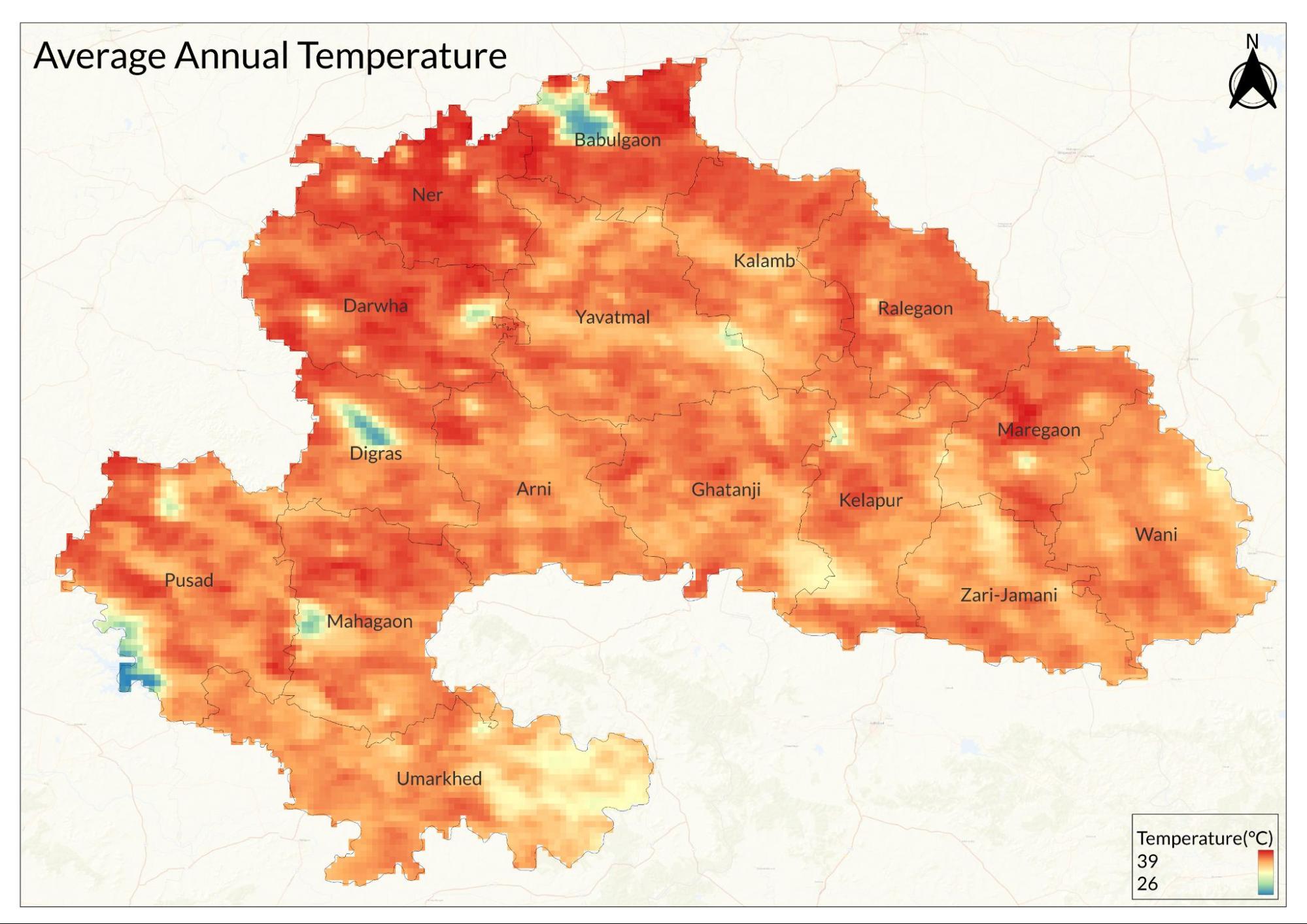
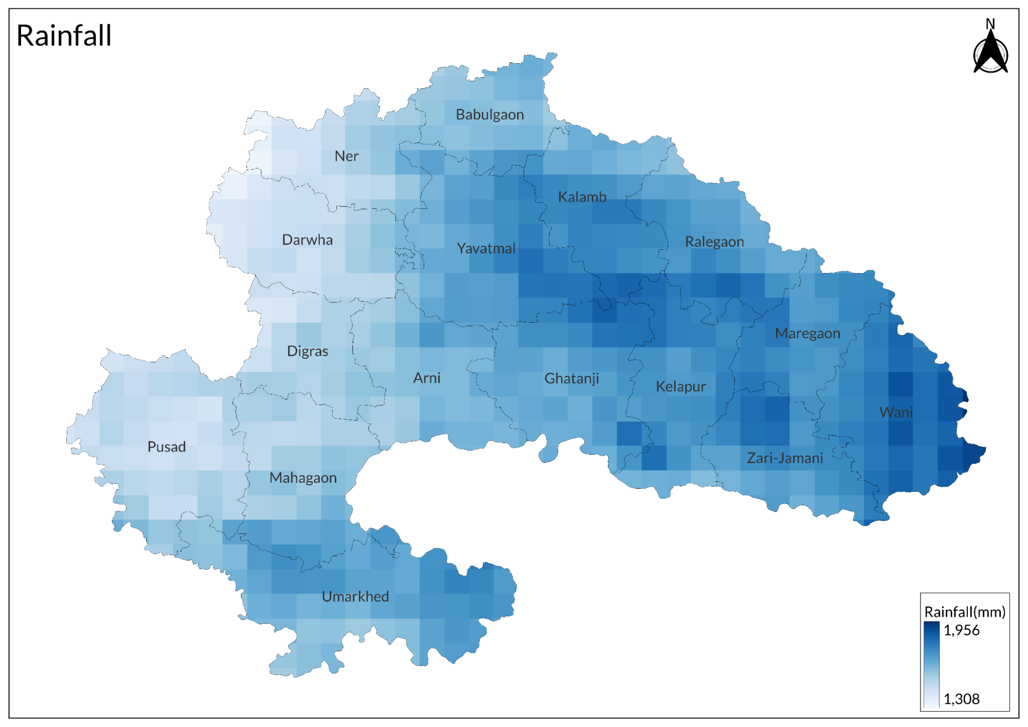
Yavatmal has a tropical wet and dry climate, receiving about 946 millimeters (37.24 inches) of rainfall annually, with an average of 53 rainy days (about 15% of the year). The average annual temperature ranges from 25ºC to 35ºC.
The district experiences hot summers and is generally dry from March to June. The cold season lasts from December to February, with December being the coldest month, averaging around 17ºC. This is followed by the hot season from March to May, with May typically being the hottest month, averaging around 43ºC. July is considered the wettest month, receiving an average rainfall of 280 mm during the southwest monsoon season. October and November mark the post-monsoon period.
Overall, Yavatmal's climate features hot summers, a rainy monsoon season, and mild winters, making it a region with distinct seasonal changes.
Geology
The geological formations can be categorized based on their age and composition. The oldest, the Archaean Group, consists of various crystalline rocks such as gneisses and schists, with valuable minerals found in the Dharwarian system. Following this is the Purana Group, which includes thick sediments like ferruginous jaspers, procellanites, shales, limestones, and sandstones.
The most recent formations belong to the Gondwana System and the Deccan Trap. The Gondwana System is known for its coal seams and sandstone formations, while the Deccan Trap is recognized for its extensive lava flows that form the Deccan plateau, covering older rocks and resulting in a landscape of terraces and flat-topped hills. At the base of the Deccan Trap lies the Lameta series of limestone beds.
Soil
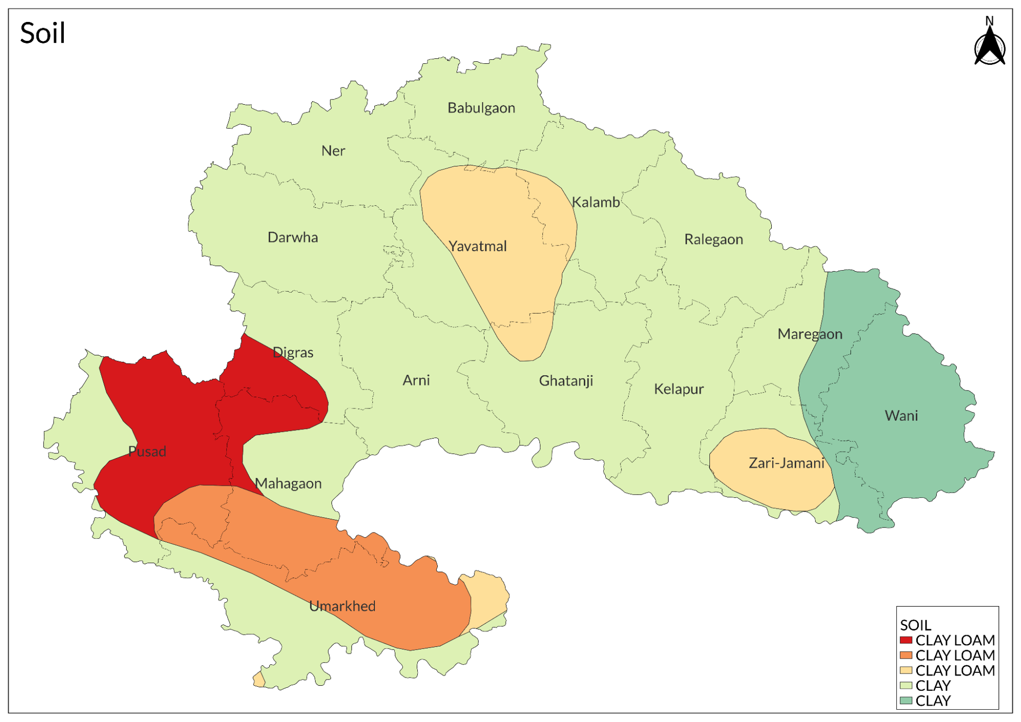
Yavatmal has three main types of soil: shallow black soil (52.2%), deep black soil (34.7%), and medium deep black soil (13%), which are primarily used for agriculture. Rich alluvial soil is found along the banks of the Penganga River, while recent alluvial soils occur in the eastern and southeastern parts of the district.
Minerals
The primary mineral resources in Yavatmal are coal and limestone. The Rajura-Wani area within the Wardha Valley coal field has approximately 240 million tonnes of coal reserves. The limestone deposits in the district, mainly located in Wani and Kelapur tehsils, are extensive and suitable for cement production and metallurgical flux. Key areas include the Rajur belt, which contains medium and fine-grained limestone and dolomite, particularly notable in the Wanjri, Majra-Pohana, and Sonapur-Lakhapur blocks. The Sindola-Chanaka and Paramdoh belt, near Khandala, Kurli, Sindola, Chanaka, and Paramdoh villages, contains cement-grade limestone. Additionally, the Chanaka-Bhimkund belt, extending through forested areas, has 31.9 million tonnes of proved cement-grade limestone along with significant amounts of inferior-grade limestone.
Rivers
The main rivers in Yavatmal district are the Wardha and the Penganga, both of which flow along the boundaries of the district and have several tributaries. According to British records, the Wardha River is also known as Vasishtha and is said to have been created by the sage Vasishtha. The riverbed of the Wardha is broad and deep, but it dries up in several places during hot weather. In contrast, the Penganga has a rougher course and flows eastward around Pusad taluka. This change in direction is referred to as Banganga. Near Murli in Pusad tehsil, there are several waterfalls, with Sahasrakund being the most prominent. It is said that Shri Parasurama, the son of Rishi Jamadagni, changed the course of the river by driving an arrow into the ground.
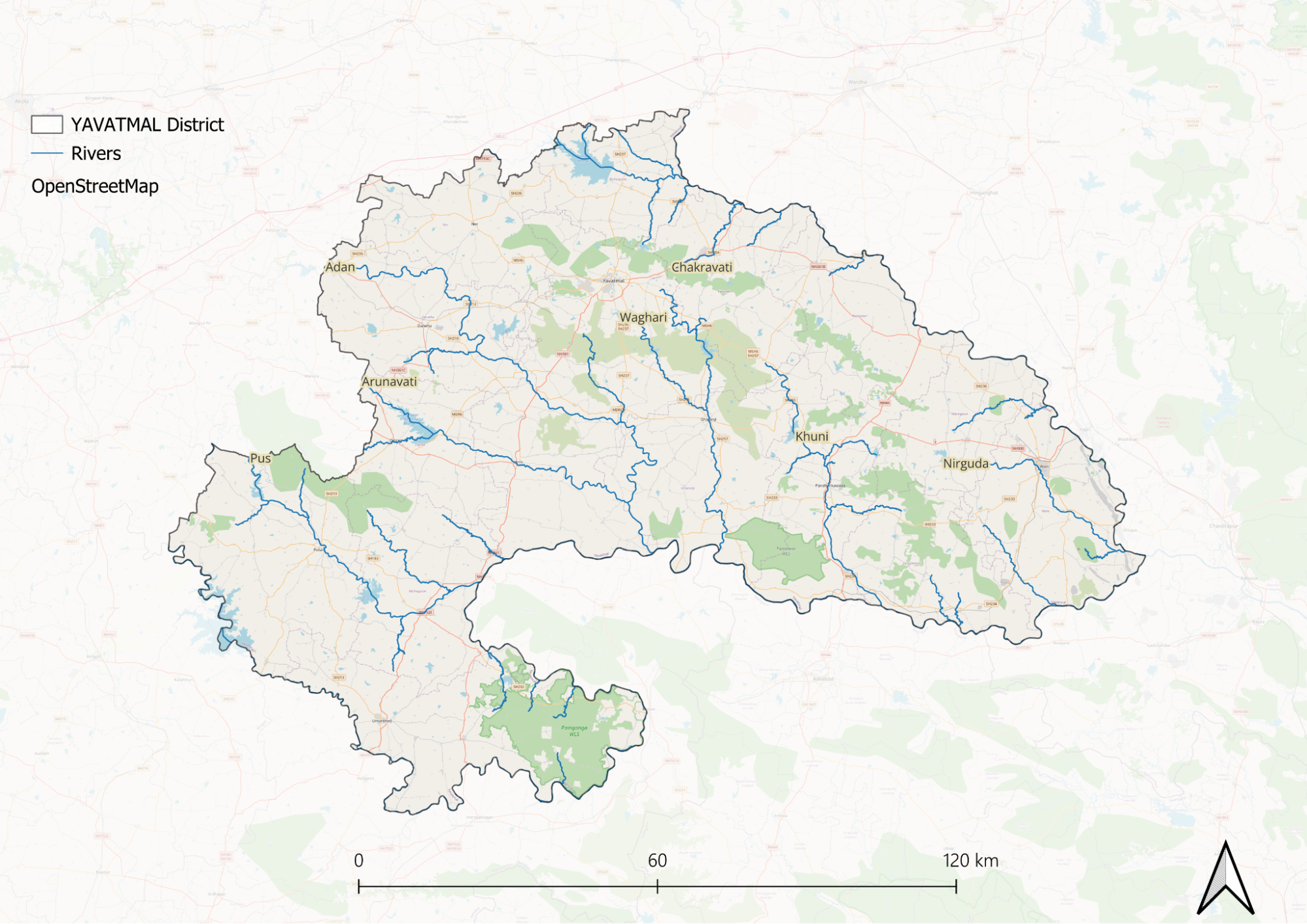
The chief tributaries of the Wardha include the Bembala and Nirguda rivers. The Bembala flows through the northern part of Yavatmal tehsil below the ghat, with a total length of about 129 kilometers, although only 34 kilometers are within the district. The Nirguda River is approximately 64 kilometers long and flows through Wun and Wani villages, maintaining a water supply year-round.
The Penganga River has six tributaries: Pus, Arnawati, Adan, Waghadi, Khuni, and Vidarbha. The Pus River flows through Pusad tehsil and has a total length of about 129 kilometers, with 80 kilometers within Yavatmal district. The Arnawati and Adan rivers flow through Darwha taluka and part of Kelapur tehsil, measuring about 113 kilometers and 130 kilometers, respectively; they unite about eight miles from the Penganga. The Waghadi and Khuni rivers flow through Kelapur tehsil, while the Vidarbha flows through the southern part of Wani taluka.
Botany
The forests of Yavatmal district are primarily dry mixed deciduous forests, with salai being the most common tree species and teak (saj) found throughout the area. Notable teak trees can be seen in the sacred grove at Dattapur in Wun tehsil and along the banks of the Penganga River. Other trees such as tiwas, tendu, babul, ain, khair, and dhaunda are used for making cart axles. Green salai is utilized for brick kilns, while there are many palas and various species of jujube.
Satinwood grows on sandstone in Wani, and tiwarang is found in Kinwat within Pusad taluka. Common trees in fields and grazing areas include mango, mahua, nim, imli, gular, pipal, Sindhi palm, tad, banyan, and ber. Only one species of bamboo is found in the forests of Kelapur and Wani.
Fodder grasses such as shar, haryali, kachori musal, kusli, pawanar, and khunda are prevalent, with almost all grasses being used, including bhondel. The tree known as tikhadi, which yields rusa oil, is widespread, while wild rice, referred to as deodhan or "God's rice," grows on riverbeds in Kinwat and Wun. Teak trees do not usually grow to a large size, and a significant amount was used for railway sleepers during the construction of the Nagpur line of the Great Indian Peninsula Railway.
Wild Animals
Monkeys, including langurs, are common in Yavatmal district, where the forest areas also provide habitat for tigers, panthers, and various deer species such as sambhar, chital, and nilgai. According to the British Gazetteer of 1908, panthers and tigers were once abundant in the district but are now found in limited numbers and are mostly confined to forest reserves. Other wildlife commonly seen in the hilly regions includes jungle cats, hunting leopards, mongooses, hyenas, wild dogs, jackals, and wolves.
The district also hosts a variety of other animals such as foxes, sloth bears, hares, blue bulls (nilgai), blackbucks, chinkaras, sambhars, and wild boars, all of which can be found in the forest reserves. The Tipeshwar Wildlife Sanctuary is particularly notable for its rich biodiversity and is home to many of these species. Visitors to the sanctuary may encounter these animals in their natural habitat while enjoying the area's scenic beauty.
Fishes
The district is home to a variety of local fish species thriving in its water bodies, with fishing activities primarily concentrated near the Wardha and Penganga rivers. Fishing also occurs in the Bembela and Nirgunda tributaries, but most fishing takes place around the tanks. Common species include Rohu, Catla, Mrigal, Ticto Barb, Olive Barb, Pool Barb, Bronze Featherback, Clown Knife Fish, Gangetic Stone Loach, River Loach, Walking Catfish, Giant Featherback, Indian Mottled Eel, Great Snakehead, Spotted Snakehead, Short-headed Nandid, Indian Glassy Fish, Highfin Glassy Perchlet, Tank Goby, Spiny Eel, and Ladder-backed Spiny Eel. These fish inhabit rivers, streams, lakes, and tanks throughout the district, each adapted to specific habitats ranging from muddy and weedy areas to rocky or sandy substrates. Fishermen primarily use various methods like "Bhawarjal" (cast net), "Pilani" (triangular scoop net), "Jappa," "Tangar," and "Zorali," along with "Attaki" for fishing activities.
Snakes
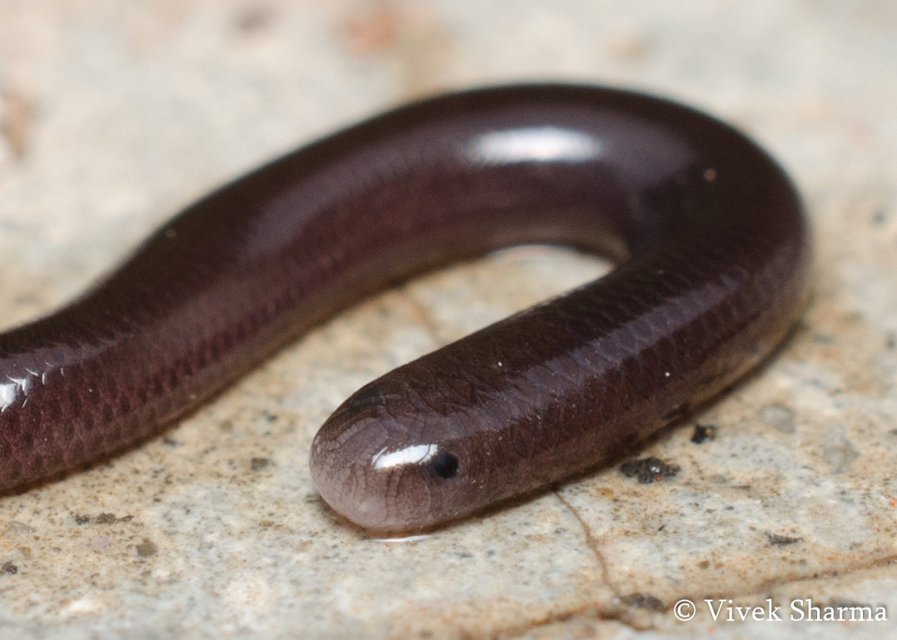
The kawdya, a brown wolf snake, frequents gardens and human settlements after the monsoon season, feeding on lizards and small rodents. The Python molurus, also called ajgar or aar, is a large snake known for its lethargic nature. Additionally, Natrix piscator, known locally as Parad, and the Shelati are commonly found near water bodies.
Forest Reserves
Tipeshwar Wildlife Sanctuary
The Tipeshwar Wildlife Sanctuary is located in Pandharkawada tehsil, approximately 75 km from Yavatmal city. Covering an area of about 149 square kilometers, the sanctuary features abundant vegetation and is surrounded by several villages that rely on the forest for firewood and timber. The terrain is hilly and undulating, resulting in diverse vegetation that varies with altitude.
The sanctuary is home to a wide range of wildlife, including hyenas, chitals, blackbucks, sambars, jackals, wild boars, peacocks, monkeys, blue bulls, wild cats, bears, and numerous bird and reptile species. Notably, the sanctuary supports a variety of mammals, including the Royal Bengal Tiger, leopards, sloth bears, and various deer species.
Tipeshwar Wildlife Sanctuary is recognized for its rich biodiversity and serves as an important habitat for both endangered and endemic species. Visitors can enjoy wildlife safaris to observe these animals in their natural environment. The best time to visit is from October to February when the weather is pleasant.
Land Use
Environmental Concerns
Deforestation
Deforestation in Yavatmal district, Maharashtra, has significantly increased due to industrial and developmental activities. A study using remote sensing images found that forest cover decreased from 76,740.32 hectares to 31,701.14 hectares between October 2019 and February 2020, a loss of 29.44%. Development projects, forest fires, and natural leaf shedding contribute to deforestation, while climate change has introduced unpredictable weather patterns affecting local ecosystems. Wildlife intrusion into agricultural lands has led to crop losses, and declining soil fertility has forced farmers to increase the use of chemical fertilizers and pesticides to sustain productivity.
Water Scarcity
A report titled Water Harvesting and Recharge Structures in Yavatmal District: A Status Check mapped 686 water structures, including check dams, percolation tanks, ponds, and reservoirs. It identified 204 check dams, with only 57.4% located in recharge zones, indicating possible misalignment for optimal groundwater recharge. Additionally, 73 check dams were found damaged or encroached upon, including 28 in critical recharge areas requiring immediate restoration.
Groundwater levels in Yavatmal have been declining at an alarming rate of approximately 4 meters, as reported by the Central Ground Water Board in 2018. This decline underscores the importance of implementing effective water conservation strategies tailored to the aquifer characteristics of the region. The report also notes that over 35% of check dams and 32% of percolation tanks are either damaged or encroached, primarily due to inadequate operation and maintenance.
Soil Degradation
Soil degradation in Yavatmal district, Maharashtra, affects agricultural productivity due to erosion, nutrient depletion, and reduced soil fertility. A reconnaissance soil survey found that soils are predominantly shallow, severely eroded, and interrupted by stony substrata, leading to rapid runoff and drought vulnerability. The district's soils include Entisol, Inceptisol, and Vertisol, with many being shallow and erosion-prone. Factors contributing to land degradation include deforestation, overgrazing, continuous cropping, and reduced use of organic fertilizers, leading to low water retention and diminished microbial activity. Crop residue burning further depletes organic carbon and increases carbon emissions, while initiatives like biochar conversion aim to enhance soil nutrient retention and microbial activity.
Graphs
Water
Climate & Atmosphere
Forests & Ecology
Human Footprint
Sources
Bhaskar, B. P., Sarkar, D., Bobade, S. V., Gaikwad, S. S., & Anantwar, S. G. 2014. Land Evaluation for Irrigation in Cotton Growing Yavatmal District, Maharashtra.International Journal of Research in Agricultural Sciences,1(2), 2348–3997.https://ijras.org/administrator/components/c…
Kearley, S. J., & MacKinlay, R. R. 1988. Discharge measurements in cables using a solid state 30 kV bipolar low frequency generator.1988 Fifth International Conference on Dielectric Materials, Measurements and Applications, 171–174.https://ieeexplore.ieee.org/document/9451
Sen, R., & Kumar, R. 2021, July 23.Yavatmal’s water security crisis. India Water Portal.https://www.indiawaterportal.org/agriculture…
Last updated on 6 November 2025. Help us improve the information on this page by clicking on suggest edits or writing to us.